47 results (displaying results 1 - 30)
First
« 1 2 » Last
Rhodos.
Bellaforest, François de
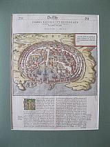
Rhodos. "
La ville de Rhodes prinse par Sultan Solyman sur les Cheualliers de Saint Iaen de Hierusalem." Paris Nicolas Chesnau, edited by Michel Sonnius 1575
Wood engraved birds eye town plan of the city of Rhodes from Bellaforest's "
La Cosmographie Universelle de Tout le Monde." modern hand colour; set in page of French text; text to verso. Dark impression; historiated initial (coloured), ruled in red ink.
152 by 210mm (6 by 8¼ inches)town plan ;page 350x245mm.
€300
Rhodos/ Rhodes, Dodecanesus.
Bertius, Petrus/ Pieter.
Jodicus Hondius II.
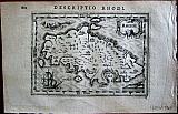
"Rhodi", "Descriptio Rhodi. " Amsterdam Jodicus Hondius Jr. 1616
Copper engraved map of Rhodos, by Hondius from Petrus Bertius :"Tabularum geographicum contractarum libri septum. " Decorative cartouche. sea monster and galleon. Latin text to verso describing the succeeding map. Dark impression. Light dampstaining to lower, blank, margin
Zacharakis 375/240; Koeman: Lan 11. 98 by 132mm (3¾ by 5¼ inches).
€180
Rhodos/Rhodes, Dodecanesus.
Bertius, Petrus/ Pieter.
Petrus Kaerius/Peiter van der Keere & Jodicus Hondius I.
"Rhodi. " Frankfurt am Main, Matthias Becker for Heinrich Lorenzen. 1612.
Copper engraved map of Rhodos/ Rhodes, from " Petri Bertii Geographischer eyn oder zusammengezogner tabeln fünff untershiedliche bücher". German text to verso. Good impression, head line and page number trimmed. upper margin short [4-5mm]; light brown staining, in printed area.
Zacharakis 1845/1220 under Langenes. B; Koeman: Lan 10. 89 by 127mm (3½ by 5 inches).
€150
An unusual map of Rhodos
Bordone, Benedetto
"Rhodo" Venice Nicolò Zappino 1528
Wood engraved map of RHodes from the "
Isolario" of Benedetto Bordone; set in a page of text with text to verso. Modern hand colour. Good impression .
Zacharakis: 517/320 60 by 142mm (2¼ by 5½ inches).
€250
Leros, Dodecannesus
Boschini, Marco.
Leros. "
Lero" Venice. Niccolini, Francesco. 1658
Copper engraved map of Leros from Boschini's "
L'Archipelago con tutte Isole, scolgio secche, e bassi fondi, con i mare, golfi, seni, porti, citta e' castelli. " Italian text to succeeding map to verso Good impression; slight show through of text from verso; modern hand colour; mounted.
Blackmer :172; Zacharakis:574/376 175 by 116mm (7 by 4½ inches).
€350
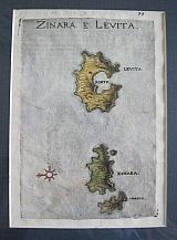
Levitha, Dodecannesus
Boschini, Marco.
Levitha & Kinaros. "
Zinara e Levita" Venice. Niccolini, Francesco. 1658
Copper engraved map of Levitha & Kinaros from Boschin's "
L'Archipelago con tutte Isole, scolgio secche, e bassi fondi, con i mare, golfi, seni, porti, citta e' castelli. " Italian text to succeeding map to verso Good impression; slight show through of text from verso; modern hand colour; mounted.
Blackmer :172; Zacharakis:570/372 175 by 116mm (7 by 4½ inches).
€200
Rhodos, Dodecanesus
Boschini, Marco.
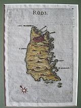
Rhodos "Rodi" Venice Niccolini, Francesco 1658
Copper engraved map of Rhodos from "L'Archipelago con tutte Isole, scolgio secche, e bassi fondi, con i mare, golfi, seni, porti, citta e' castelli. " Italian text to succeeding map to verso. Modern hand colour. Good impression, show through of text and engraved tail piece from. verso
Blackmer :172; Zacharakis:547/349. 173 by 120mm (6¾ by 4¾ inches).
€500
Tilos, Dodecannesus
Boschini, Marco.
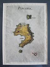
Tilos. "
Piscopia" Venice. Niccolini, Francesco. 1658
Copper engraved map of Tilos from Boschini's "
L'Archipelago con tutte Isole, scolgio secche, e bassi fondi, con i mare, golfi, seni, porti, citta e' castelli. " Italian text to succeeding map to verso Good impression, show through of text and endpiece from verso.
Blackmer :172; Zacharakis:550/352 175 by 116mm (7 by 4½ inches).
€300
Karpathos, Dodecanesus.
Camocio, Giovanni Francisco.
Karpathos. "
Scarpanto." Venice. Ferrando and/or Donato Bertell. 1566-74
Copper engraved view of the island of Karpathos from Camoccio's "
Isole Famose Porti, Fortezze E Terre Maritime" . Verso blank. Dark impression; light soiling mainly to margins.
Blackmer /Navari:274; Zacharakis:799/525. 211 by 153mm (8¼ by 6 inches).
€750
The Island of Patmos
Camocio, Giovanni Francisco.
Patmos "
Pamosa....." Venice Ferrando and/or Donato Bertell. 1566-74
Copper engraved view of the island of Patmos from Camoccio's "
Isole Famose Porti, Fortezze E Terre Maritime" . Modern hand colour; verso blank.
The map shows the monastery of St John as a large edifice in the centre of the island.
decorative title cartouche with long text describing the island and its history. Dark impression; modern hand colour; mounted.
Blackmer /Navari:274; Zacharakis:787/514. 210 by 155mm (8¼ by 6 inches).
€1000
The City and Port of Rhodes.
Camocio, Giovanni Francisco.
The City of Rhodes. "
Rhodi Citta." Venice Ferrando and/or Donato Bertell. 1566-74
Copper engraved view of the port of Rhodes from Camoccio's "
Isole Famose Porti, Fortezze E Terre Maritime" . Modern hand colour; verso blank Dark impression .
Blackmer /Navari:274; 163 by 205mm (6½ by 8 inches).
€600
View of the Fort of Kalymnos, Dodecannesus.
CORONELLI, Vincenzo Maria.
Island & Fort of Kalymnos "
Isola e Forte di Calamo." Venice CORONELLI, Vincenzo Maria. 1696
Vignette viewof Kalymnos from CORONELLI's "
Isolario descrittione geografico-historia... Tomo II dell' Atlante Veneto." Modern hand colour.
The view was one of the vignettes of Coronelli's "
Isolario descrittione geografico-historia... Tomo II dell' Atlante Veneto." appearing within the text ; it also appeared in his work "
Isola Di Rodi" published in 1688 & 1695. Good Impression.[ Mounted and handcoloured.]
125 by 164mm (5 by 6½ inches).
€150
Kalymnos, Dodecannesus.
CORONELLI, Vincenzo Maria.
Kalymnos. "
Isola di Calamo nel Arcipel." Venice CORONELLI, Vincenzo Maria. 1696
Vignette map of Kalymnos from CORONELLI's "Isolario descrittione geografico-historia... Tomo II dell' Atlante Veneto." Modern hand colour.
The map was one of the vignettes of Coronelli's "Isolario descrittione geografico-historia... Tomo II dell' Atlante Veneto." appearing within the text ,; it also appeared in his work "Isola Di Rodi" published in 1688 & 1695.
The island is engraved upon a draped cloth. Good Impression.[ Mounted and handcoloured.]
Zacharakis :1134/695 125 by 164mm (5 by 6½ inches).
€150
View of Kos, Dodecanesus.
CORONELLI, Vincenzo Maria.
Kos. "
Stanchio à Stango." Venice CORONELLI, Vincenzo Maria. 1696
Vignette view of Kos from Coronelli's "Isolario descrittione geografico-historia... Tomo II dell' Atlante Veneto." Modern hand colour.
The map was one of the vignettes of Coronelli's "Isolario descrittione geografico-historia... Tomo II dell' Atlante Veneto." appearing within the text ; it also appeared in his work "Isola Di Rodi" published in 1688 & 1695. Good Impression.[ Mounted and handcoloured.]
130 by 166mm (5 by 6½ inches).
€150
Tilos, Dodecanesus.
CORONELLI, Vincenzo Maria.
Tilos. "
Isola di Piscopia." Venice CORONELLI, Vincenzo Maria. 1696
Vignette map of Tilos from Coronelli's "Isolario descrittione geografico-historia... Tomo II dell' Atlante Veneto." Modern hand colour.
The map was one of the vignettes of Coronelli's "Isolario descrittione geografico-historia... Tomo II dell' Atlante Veneto." appearing within the text ; it also appeared in his work "Isola Di Rodi" published in 1688 & 1695.
The island is engraved upon a draped cloth. Good Impression.[ Mounted and handcoloured.]
Zacharakis :1131/692 124 by 163mm (5 by 6½ inches).
€150
The First Printed Map of Patmos.
Dalli Sonetti, Bartolomeo
Patmos. "
Pactamos." Venice. Guilelmus Anima Mia, Tridinensis, 1485-6
Woodcut map with original handcolour of Patmos from the first printed maritime atlas: Bartolomeo Dalli Sonetti's "
Isolario". text to verso [ sonnet: description of Lipsos ]
The island within a wind rose has the Monastery of Saint John of the Apocalypse in the centre of the island within the town of Chora the capital. The Cave of the Apocalypse is also marked, plus 2 other settlements The cartography is naive but if seen as just the southern part of the island it makes more sense. Light dampstaining to lower part of page; ink number to upper right corner.
Zacherakis:3396/2224. 230 by 163mm (9 by 6½ inches) full page.
€6000
The First Printed Map Of Tilos.
Dalli Sonetti, Bartolomeo
Tilos "
Piscopia" Venice. Guilelmus Anima Mia, Tridinensis, 1485-6
Woodcut map with original handcolour of Tilos from the first printed maritime atlas: Bartolomeo Dalli Sonetti's "
Isolario". text to verso [ sonnet: description of Nisyros ]
The island within a wind rose has 3 settlements shown. The cartography is naive. Repaired small hole to lower part of island due to oxidation of colour; light dampstaining to lower part of page and left edge; ink number to upper right corner, dampstain to the same corner; annotated with roman numerals near "A" of windrose.
Zacherakis:3370/2198. 230 by 163mm (9 by 6½ inches) full page.
€2500
Kalogeros/ Kaloiero, Dodecanesus.
Dapper, Olfert
"Klip Kaloiero, anders Panaia. " "De Klip van Kaloiero" Amsterdam Wolfgangh, Waesbergen, Boom. Someren en Goethals 1688
Cpper engraved view of the Rock Kalogeros, near Nisaros. with the monastry on the peak, and a small boat being winched up from the sea. . set in a page of dutch text, [page84].
From Olfert Dapper's" Naukeurige Beschryving der Eilanden in de Archipel der Middelantsche Zee"1688. Single page, folio, text to verso. Dark impression with wide margins.
127 by 158mm (5 by 6¼ inches).
€60
Symi, Tilos, Nisyros, Chalki & Alimia. Dodecanesus
Dapper, Olfert
"Nisari", "Le Simie", "Carchi e Limonia". "Piscopia" Amsterdam Wolfgangh, Waesbergen, Boom. Someren en Goethals 1688
Copper engraved maps of Symi [and Nimos], Tilos, Nisyros, Chalki & Alimia. 4 maps on one plate.
From Olfert Dapper's" Naukeurige Beschryving der Eilanden in de Archipel der Middelantsche Zee"1688. Double page, folio, verso blank. Good impressions, wide margins. Some dust soiling. light dampstaining to lower blank margin. backed with old paper [before binding?]
Zacherakis1299/883 260 by 350mm (10¼ by 13¾ inches).
€350
Kos, Dodecanesus
Dapper, Olfert
Kos/Cos "Eylant Stanko of Lango" Amsterdam Wolfgangh, Waesbergen, Boom. Someren en Goethals
Copper engraved map of Kos in the Dodecnesus, also known as Lango by the Italians or Stanko by the Turks. Set in a page of Dutch text [page 36].
From Olfert Dapper's" Naukeurige Beschryving der Eilanden in de Archipel der Middelantsche Zee"1688. Single page, folio, text to verso. Dark impression withwide margins.
Zacharakis 1301/885 126 by 163mm (5 by 6½ inches).
€220
Rhodos/ Rhodes, Dodecanesus.
Dapper, Olfert
Rhodes "Rhodos" Amsterdam Wolfgangh, Waesbergen, Boom. Someren en Goethals
Copper engraved birds eye town plan of " Old" Rhodes in the Dodecanesus. Set in a page of Dutch text [page 14].
From Olfert Dapper's" Naukeurige Beschryving der Eilanden in de Archipel der Middelantsche Zee"1688. Single page, folio, text to verso. Dark impression with wide margins. small rust spot in centre of print,
131 by 161mm (5¼ by 6¼ inches).
€60
Rhodos/ Rhodes, Dodecanesus.
Dapper, Olfert
Rhodos Town plans through the ages. "Afbeelding der oude Stad Rhodus", "Platte gront der Stad rhodus", " DeHedendaegshe Stad en Haven van Rhodus" Amsterdam Wolfgangh, Waesbergen, Boom. Someren en Goethals 1688
Double page copper engraving showing the City of Rhodes, through the ages. 3 town plans on 1 plate. Folio, Verso blank
From Olfert Dapper's" Naukeurige Beschryving der Eilanden in de Archipel der Middelantsche Zee"1688. Dark impression with good margins.
278 by 350mm (11 by 13¾ inches).
€180
Kos, Dodecannesus.
Lasor, a. Varea Alphonse [ also known under the pseudonym R Savonarola.]
Kos. "
Lango." Padua : ex typographia olim Frambotti, nunc Jo. Baptistae Conzatti. 1713
Copper engraved map of Kos from Lasor's "
Universus terrarum orbis scriptorum calamo delineatus ... qui de Europae, Asiae, Africae, & Americae regnis, provinciis, populis, civitatibus....", modern hand colour; half page surrounded by texttext to verso.
The map is taken from Rosaccio's"
Viaggi a Costantinopoli," in 1598. Good impression ; modern hand colour; mounted.
Zacharakis:1871/1244;Cox II, 542: 'a most remarkable book'; Graesse IV, 115; Sabin 39133; Shirley BL, T.LAS-1a. 97 by 168mm (3¾ by 6½ inches).
€200
Rhodos, Dodecannesus.
Lasor, a. Varea Alphonse [ also known under the pseudonym R Savonarola.]
Rhodes. "
Isola de Rhodi." Padua : ex typographia olim Frambotti, nunc Jo. Baptistae Conzatti. 1713
Copper engraved map of Rhodes from Lasor's "
Universus terrarum orbis scriptorum calamo delineatus ... qui de Europae, Asiae, Africae, & Americae regnis, provinciis, populis, civitatibus....". Modern hand colour; set in a psge of text; text to verso.
The map is by Natale Bonifazio [ Bonifacio] Sibenicensis engraver who worked producing maps and engravings first in Venice where his maps were published by amongst others Camoccio and Bertelli and then in Rome where he was part of the Lafrerei school of engravers.
Page number to upper right corner and monogramm "NB F" to lower corner.
Compass rose and ship to sea. Good impression ; modern hand colour; mounted.
Zacharakis:1858/1231; Cox II, 542: 'a most remarkable book'; Graesse IV, 115; Sabin 39133; Shirley BL, T.LAS-1a. 209 by 152mm (8¼ by 6 inches).
€450
Skyros.
Lasor, a. Varea Alphonse [ also known under the pseudonym R Savonarola.]
Skyros. "
Scyro." Padua : ex typographia olim Frambotti, nunc Jo. Baptistae Conzatti. 1713
Copper engraved map of the Skyros from Lasor's "
Universus terrarum orbis scriptorum calamo delineatus ... qui de Europae, Asiae, Africae, & Americae regnis, provinciis, populis, civitatibus....". Modern hand colour; set in a page of text; text to verso.
The map is from the plate of Rosaccio in his
Viaggio da Venetia a Constantinopoli.published in 1598. [ Zacahrakis;29471/1953] Good impression ; modern hand colour; mounted.
Zacharakis:1881/1254; Cox II, 542: 'a most remarkable book'; Graesse IV, 115; Sabin 39133; Shirley BL, T.LAS-1a. 100 by 170mm (4 by 6¾ inches).
€150
Ikaria.
Lasor, a. Varea Alphonse [also known under the pseudonym R Savonarola.]
Ikaria. "
Nicaria" Padua : ex typographia olim Frambotti, nunc Jo. Baptistae Conzatti. 1713
Copper engraved map of Ikaria from Lasor's "
Universus terrarum orbis scriptorum calamo delineatus ... qui de Europae, Asiae, Africae, & Americae regnis, provinciis, populis, civitatibus....". Modern hand colour; half page surrounded by text; text to verso
The map is from the plate of Rosaccio in his
Viaggio da Venetia a Constantinopoli.published in 1598. [ Zacahrakis;2968/1950] Good impression ; modern hand colour; mounted.
Zacharakis:1886/1260; Cox II, 542: 'a most remarkable book'; Graesse IV, 115; Sabin 39133; Shirley BL, T.LAS-1a. 100 by 175mm (4 by 7 inches).
€160
Kos, Kalymnos & Leros, Dodecanesus.
Mallet, Allain Manesson.
"I. s de lero, Calamo et de Lango". Paris Thierry. Denys. 1683
Copper engraved map of Kos, Kalymnos & Leros in the Dodecanesus from Mallet's "Description de l'Univers" 1st edition. Text to verso. Dark impression.
Zacharakis 2129/1393 150 by 106mm (6 by 4¼ inches).
€70
Ikaria & Patmos, Dodecanesus.
Mallet, Allain Manesson.
"I. s de Nicaria et Palmos". Paris Thierry. Denys. 1683
Copper engraved map of Ikaria and Patmos, from Mallet's "Description de l'Univers" 1st edition. Text to verso. Dark impression.
Zacharakis 2135/1399 146 by 105mm (5¾ by 4¼ inches).
€70
Nisaros & Tilos, Dodecanesus.
Mallet, Allain Manesson.
"i. s de nisaro et de Piscopia". Paris Thierry. Denys. 1683
Copper engraved map of Nisaros and Tilos laying off the coast of Turkey; with Kos in the background, from Mallet's "Description de l'Univers" 1st edition. Text to verso. Dark impression: "FIGURE CXXIV" touching platemark but outside printed area.
Zacharakis 2130/1394 150 by 104mm (6 by 4 inches).
€60
Rhodos, Dodecanesus.
Mallet, Allain Manesson.
"Isle de Rhodes". Paris Thierry. Denys. 1683
Copper engraved map of Rhodos laying off the coast of Turkey, also showing Simie from Mallet's "Description de l'Univers" 1st edition. Text to verso. Dark impression.
Zacharakis 2131/1395 150 by 105mm (6 by 4¼ inches).
€80
47 results (displaying results 1 - 30)
First
« 1 2» Last