MAPS & VIEWS
PRINTS
BOOKS
Paros, Cyclades.
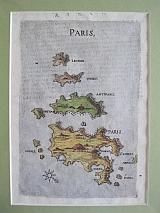 Paros & Antiparos. "Paris" Venice. Niccolini, Francesco. 1658
Copper engraved map of Paros & Antiparos from Boschini's "L'Archipelago con tutte Isole, scolgio secche, e bassi fondi, con i mare, golfi, seni, porti, citta e' castelli. " Italian text to succeeding map to verso, modern hand colour. Good impression; slight show through of text from verso; modern hand colour; mounted.
Blackmer :172; Zacharakis:565/367 175 by 116mm (7 by 4½ inches). €600
Paros, Cyclades.
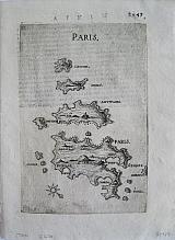 Paros & Antiparos. "Paris" Venice. Niccolini, Francesco. 1658
Copper engraved map of Paros & Antiparos fromoschini's "L'Archipelago con tutte Isole, scolgio secche, e bassi fondi, con i mare, golfi, seni, porti, citta e' castelli. " Italian text to succeeding map to verso, black & white. Good impression; slight show through of text from verso.
Blackmer :172; Zacharakis:565/367 175 by 116mm (7 by 4½ inches). €600
Castle of Pediada,Kastelli Pediados; Crete.
 Pediada Castle, "Castel Pediada" Venice "Marco Boschini Venetiano, al Serinissima Principe E Regal Collegio di Venetia" 1651
Black & white copper engraved birdseye view/ map of the castle of Pediada from Marco Boschini's "Il Regno tutto di Candia"single page; verso blank.
The view/ map shows the castle of Pediada now the site of the village of Kastelli Pediados; nothing remains of the fort. Dark impression, on laid paper.
Not described by Zacherakis; Blackmer /Navari:171; Blackmer/Sotheby's:37. 217 by 161mm (8½ by 6¼ inches). €400
Port of Atali,Bali, Crete.
 Port of Atali "Porto di atali" Venice "Marco Boschini Venetiano, al Serinissima Principe E Regal Collegio di Venetia" 1651
Black & white copper engraved birdseye view/ map of the port of Atali from Marco Boschini's "Il Regno tutto di Candia"single page; verso blank.
The view/ map shows the castle of port of Atali, now called Bali.
Bali is built on the site of the ancient city Astali, which was the port of Axos. Astali is linked to the city the legendary giant of Crete, Talos, stopped during his journey. Thus, the mountains south of the village are called Talean Mountains, after Talos. During the Venetian Era, this name was paraphrased to Atali, a name that is still live in the nearby monastery of Atalis. The present name is derived from Turks. Balli in Turkish means "honey" and the area was named so because of the many beehives. According to other beliefs, the fishing village was name Bali after the Turkish word ballik, which means fish Dark impression, on laid paper; some light soiling to blank margins.
Zacherakis:606/408; Blackmer /Navari:171; Blackmer/Sotheby's:37. 210 by 160mm (8¼ by 6¼ inches). €300
Kali Limenes, Crete.
 Port of Kali Limenes. "Porto di Caluslimiones." Venice "Marco Boschini Venetiano, al Serinissima Principe E Regal Collegio di Venetia" 1651
Black & white copper engraved birdseye view/ map of the coast at Kali Limenes from Marco Boschini's "Il Regno tutto di Candia"single page; verso blank.
The view/ map shows the coast at Kali Limenes,looking across to the Islands of Mikronisi and Megalonisi. sShips to sea. Dark impression, on laid paper; light dampstain to edge of right blank margin.
Zacherakis:630/432; Blackmer /Navari:171; Blackmer/Sotheby's:37. 216 by 162mm (8½ by 6½ inches). €400
Marathi , Crete
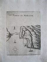 Port of Marathii. " Porto di Marathi" Venice "Marco Boschini Venetiano, al Serinissima Principe E Regal Collegio di Venetia" 1651
Black & white copper engraved map/viewof the port of Marathi, Crete from Marco Boschini's "Il Regno tutto di Candia" single page; verso blank.
The map/view shows the port of Marathi on the Akrotiri peninsular at the entrance of Suda bay. Dark impression, on laid paper; light soiling to outer margins.
Zacherakis:599/401; Blackmer /Navari:171; Blackmer/Sotheby's:37. 213 by 163mm (8½ by 6½ inches). €350
Port Tigani, Heronissos, Crete.
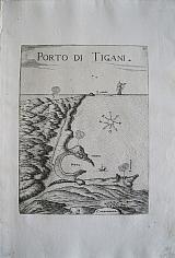 Port of Tigani, Heronissos Crete "Porto di Tigani" Venice "Marco Boschini Venetiano, al Serinissima Principe E Regal Collegio di Venetia" 1651
Black & white copper engraved birdseye view/ map of the port of Tigani, Heronissos , from Marco Boschini's "Il Regno tutto di Candia"single page; verso blank.
The view/ map shows the coast and the ancient port of Heronissos. During the Venetian occupation , the place was called Puerto Tigani, and gave shelter to many ships during the Middle Ages, before entering a slow but steady decline, which ultimately reduced the city to a handful of houses. The decline was mainly due to the activity of pirates, Saracens and others who with their attacks and looting forced the inhabitants to seek shelter on the slopes of the surrounding mountains.
On the horizon is named the peninsular of Santa Zorzi and in the foreground the settlement of Zabagnana. there is also a large ship on the horizon. Dark impression, on laid paper.
Zacherakis: 615/417; Blackmer /Navari:171; Blackmer/Sotheby's:37. 218 by 162mm (8½ by 6½ inches). €300
Zakros, Crete.
 Port of Zakros. "Porto di Xacro" Venice "Marco Boschini Venetiano, al Serinissima Principe E Regal Collegio di Venetia" 1651
Black & white copper engraved birdseye view/ map of the port of Zakros in eastern Crete from Marco Boschini's "Il Regno tutto di Candia"single page; verso blank.
The view/ map shows thebay and port of Zakros in eastern Crete. Dark impression, on laid paper; dampstain to right blank margin.
Zacherakis:624/426; Blackmer /Navari:171; Blackmer/Sotheby's:37. 216 by 164mm (8½ by 6½ inches). €400
Psara, Cyclades.
 Psara. "Psara" Venice. Niccolini, Francesco. 1658
Copper engraved map of Psara from Boschini's "L'Archipelago con tutte Isole, scolgio secche, e bassi fondi, con i mare, golfi, seni, porti, citta e' castelli. " Italian text to succeeding map to verso, modern hand colour. Good impression; slight show through of text from verso; modern hand colour; mounted.
Blackmer :172; Zacharakis:580/382. 175 by 116mm (7 by 4½ inches). €400
Rhodos, Dodecanesus
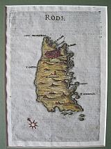 Rhodos "Rodi" Venice Niccolini, Francesco 1658
Copper engraved map of Rhodos from "L'Archipelago con tutte Isole, scolgio secche, e bassi fondi, con i mare, golfi, seni, porti, citta e' castelli. " Italian text to succeeding map to verso. Modern hand colour. Good impression, show through of text and engraved tail piece from. verso
Blackmer :172; Zacharakis:547/349. 173 by 120mm (6¾ by 4¾ inches). €500
Santorini, Cyclades.
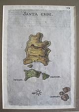 Santorini. "Santa Erini" Venice. Niccolini, Francesco. 1658
Copper engraved map of Santorini from Boschini's "L'Archipelago con tutte Isole, scolgio secche, e bassi fondi, con i mare, golfi, seni, porti, citta e' castelli. " Italian text to succeeding map to verso, modern hand colour. Good impression; slight show through of text from verso; modern hand colour; mounted.
Blackmer :172; Zacharakis:554/356 175 by 116mm (7 by 4½ inches). €750
Schinoussa, Iraklia, Keros, Cyclades.
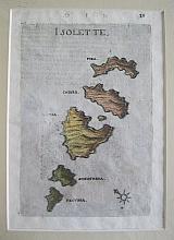 Schinoussa, Iraklia, Keros "Isolette" Venice. Niccolini, Francesco. 1658
Copper engraved map of Schinoussa, Iraklia, Keros and other small islands from Boschini's "L'Archipelago con tutte Isole, scolgio secche, e bassi fondi, con i mare, golfi, seni, porti, citta e' castelli. " Italian text to succeeding map to verso Good impression; slight show through of text from verso; modern hand colour; mounted.
Blackmer :172; Zacharakis:567/369 175 by 116mm (7 by 4½ inches). €250
Sittia, Crete.
 Sittia "Settia" Venice "Marco Boschini Venetiano, al Serinissima Principe E Regal Collegio di Venetia" 1651
Black & white copper engraved birdseye view/ map of the bay & city of Sittia from Marco Boschini's "Il Regno tutto di Candia"single page; verso blank.
The view/ map shows the bay and city of Sittia. Ship & large fish to sea. Dark impression, on laid paper; llght soiling to blank margins.
Zacherakis: 622/424; Blackmer /Navari:171; Blackmer/Sotheby's:37. 216 by 164mm (8½ by 6½ inches). €400
Sittia, Crete.
 Sittia "Settia" Venice "Marco Boschini Venetiano, al Serinissima Principe E Regal Collegio di Venetia" 1651
Black & white copper engraved birdseye view/ map of the city of Sittia from Marco Boschini's "Il Regno tutto di Candia"double page, folded; verso blank.
The view/ map shows city of Sittia with its fortified walls.. Dark impression, on laid paper; folded; some creasing; llght soiling to blank margins.
Not described by Zacherakis; Blackmer /Navari:171; Blackmer/Sotheby's:37. 213 by 390mm (8½ by 15¼ inches). €650
Dia Island, Crete.
 Standia Island. "Standia Isola" Venice "Marco Boschini Venetiano, al Serinissima Principe E Regal Collegio di Venetia" 1651
Black & white copper engraved birdseye view/ map of Dia island from Marco Boschini's "Il Regno tutto di Candia"single page; verso blank.
Ships to the sea.
Standia or Dia island lies of Iraklion, from where it looks like a giant lizard which led to a legend that a giant lizard tried to destroy the island of Crete, but Zeus turned it in to stone with a thunderbolt, thus creating the island; it also features in mythology as the island Theseus escaped to after killing the Minotaur. The island is now a nature reserve with a number of protected species and plants. Dark impression, on laid paper, soiling to blank margins; light stain to lower margin entering image;dampstain to right, blank margin.
Zacherakis: 611/413; Blackmer /Navari:171; Blackmer/Sotheby's:37. 220 by 165mm (8¾ by 6½ inches). €400
Temenos Fortress, Kanli Castelli, Crete.
 Temenos Castle. "Castel Temene" Venice "Marco Boschini Venetiano, al Serinissima Principe E Regal Collegio di Venetia" 1651
Black & white copper engraved birdseye view/ map of the castle of Temene from Marco Boschini's "Il Regno tutto di Candia"single page; verso blank.
The view/ map shows the castle of Temenos,and the village called Kanli Castelli, today known as Prophet Elijah, The village is situated at the foot of the steep two-peaked hill Rocca, at the start of Malades valley
The hill was ideal for the construction of an impregnable castle, as it dominates throughout the surrounding area. Also, there was a natural fresh water source on Rocca, which fed the fountain Fountana, located inside the fort.
Rocca is believed to be the acropolis of the ancient city Lykastos, mentioned by Homer. Much later, when Nicephorus Phocas liberated Crete from the Saracen pirates in 961AD, he first founded a fort on Rocca, in order to transfer the city of Candia there. The fort was built, but Candia was not moved, as its port was very important for the Cretans. Thus, the fortress was left alone overlooking the region and was named Temenos. Even today, the whole province is called Temenos Province.
During the Cretan War, i.e. the war between Venetian-Cretans and Turks, most battles took place in the countryside, as the Great Castle of Candia resisted for 22 years. In the wider area of Iraklion, Christians were led by the abbot of the monastery Agarathos, Athanasios Christoforos and the scholar Gerasimos Vlachos, while the Venetian general Gildasis (Gil d 'Has) attacked the Turks in several places. During one of these attacks, in 1647, Gil d' Has attacked the Turks who had occupied the fortress Temenos, slaughtering almost all of them. In 1669, after the Turks conquered Candia, the fort was donated by the Sultan to the Venetian traitor of Candia, Andrea Barozzi. The fort was then named Kanli Castelli, i.e. bloody fort, so as to commemorate the massacre of the Turkish army in 1647. However, there were references to the fort, naming it as Nefs Temenos. Dark impression, on laid paper.
Not described by Zacherakis; Blackmer /Navari:171; Blackmer/Sotheby's:37. 217 by 163mm (8½ by 6½ inches). €400
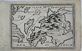
The East Coast of the Peloponnesus.
 The East Coast of the Peloponnesus. "Damala et Altreis" Venice. Niccolini, Francesco. 1658
Copper engraved map of the eastern part of the Peloponnesus from Boschini's "L'Archipelago con tutte Isole, scolgio secche, e bassi fondi, con i mare, golfi, seni, porti, citta e' castelli. " Italian text to succeeding map to verso; modern hand colour.
The unusual map shows the coast of Argolis and the Argo-Saronic gulf. Portrayed with south at the top it is more recognisable when turned 180 degrees showing the Isthmus of Corinth, the islands of the Saronic gulf, Aegina, Methana [Damala of the title], Hydra, Poros ,and Spetze. the Argolic gulf with Nafplion and the coast down to Neapolis, including monomvasia. Good impression; slight show through of text from verso; modern hand colour; mounted.
Blackmer :172; Zacharakis:591/393. 175 by 116mm (7 by 4½ inches). €500
The Venetian Kingdom of Crete.
 The Kingdom of Crete. "l Regno di Candia." Venice "Marco Boschini Venetiano, al Serinissima Principe E Regal Collegio di Venetia" 1651
Copper engraved map of Crete, the general map of Marco Boschini's "Il Regno tutto di Candia." folded, verso blank. 2 medallions, 1 with the lion of Venice surmounted by a crown.
A detailed map showing the mountainous nature of the island, and naming of all the coastal settlements; Elizabeth Clutton feels that it was based on the earlier map of Francesco Basilcata. Dark impression; very pale dampstain to upper margin.
Zacherakis: 592/394. Blackmer /Navari:171; Blackmer/Sotheby's:37. 224 by 428mm (8¾ by 16¾ inches). €3200
Tilos, Dodecannesus
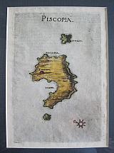 Tilos. "Piscopia" Venice. Niccolini, Francesco. 1658
Copper engraved map of Tilos from Boschini's "L'Archipelago con tutte Isole, scolgio secche, e bassi fondi, con i mare, golfi, seni, porti, citta e' castelli. " Italian text to succeeding map to verso Good impression, show through of text and endpiece from verso.
Blackmer :172; Zacharakis:550/352 175 by 116mm (7 by 4½ inches). €300
Tsoutsouras, Crete.
 Tsoutsouras beach. "Spiaggi di Zuzzuro" Venice "Marco Boschini Venetiano, al Serinissima Principe E Regal Collegio di Venetia" 1651
Black & white copper engraved birdseye view/ map of the beach at Tsoutsouras from Marco Boschini's "Il Regno tutto di Candia"single page; verso blank.
The view/ map shows the beach at Tsoutsouras; ship and fish to sea. Dark impression, on laid paper; light dampstain to edge of right blank margin.
Zacherakis:631/433; Blackmer /Navari:171; Blackmer/Sotheby's:37. 217 by 165mm (8½ by 6½ inches). €300
Scarce miniature map of Kefalonia
 Kefalonia, "Isle de Cefalonie" Antwerp par Henrt Van Dunwalt et Jasper Bouttats 1688
Copper engraved, black and white miniature map of Kefalonia by Gaspar Bouttats, from"Courte description du Royaume de la Morea et les places Maritime par Henrt Van Dunwalt et Jasper Bouttats"
The map is after the cartography of Coronelli, the text is in french and the whole is within and engraved frame, Dark impression; light toning; small string holes to left edge from binding.
Zacharakis:667 298 by 140mm (11¾ by 5½ inches). €300
Rare view of Aachen, Germany.
 Frans Hogenberg & Simon Novellanus`
Aachen. [Aix-la-Chapelle. ] "Aquisgranum" [ "Aich"] Cologne Theodori Graminæi. 1572
Frans Hogenberg & Simon Novellanus`
Aachen. [Aix-la-Chapelle. ] "Aquisgranum" [ "Aich"] Cologne Theodori Graminæi. 1572Copper engraved view of Aachen from the first volume of Braun & Hogenberg's "Civitas Orbis Terrarum. " Latin text to verso. The rare first state view, which was replaced with a town plan in later editions
Aachen, [Aix-la-Chapelle] was the winter residence of Charlemagne, and the site of coronations of the Kings of Germany. Dark impression; a few light stains to blank margins.
Keoman vol2; B&H1/12 290 by 362mm (11½ by 14¼ inches). €650
Bird's Eye view of Alexandria.
 Alexandrie. Alexandria.. Cologne G. von Kempen 1575
Black and white, copper engraved bird's eye view of Alexandria from the second volume of Braun & Hogenberg's Civitas Orbis Terrarum. French text to verso.
Title Cartouche to top centre.
The view shows the port city enclosed by walls with various branches of the Nile running through the city; numerous ships and galleas to the sea and camels and palm trees to the land. Important buildings are named including the Pharos[ lighthouse], one of the Seven Wonders of the World and Pompey's Pillar.
Dark impression.
Keoman 2; B&H 14, [plate 56]. 367 by 482mm (14½ by 19 inches). €750
Bird's eye View of Amsterdam.
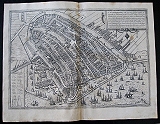 Amsterdam. Amsterdanum. Cologne G. von Kempen 1575
Black and white, copper engraved birds eye view of Amsterdam from the first volume of Braun & Hogenberg's Civitas Orbis Terrarum. French text to verso.
Very desirable and early town-plan of Amsterdam from a north-easterly direction. With a numbered key (1-28) in lower left corner.
On the left-hand side we can see how the mouth of the River Amstel has been dammed and its waters channeled into canals and made to pass through the city before flowing out into the Zuiderzee (today the IJsselmeer). The canals, which were used to transport imported goods to the counting houses located all over the city, are lined with private houses, commercial buildings and warehouses. In the center of the plan, the old town hall (Stadhuis, 21) and the neighboring Nieue Kerk (23) are also clearly recognizable. With its depiction of the heavy shipping traffic inside the harbour and on the Zuiderzee, the engraving conveys an impression of the contemporary scale of trade conducted in the continually expanding metropolis.
In the 13th century Amsterdam was simply a small fishing port built on marshy ground. In 1300 it was granted its municipal charter and in 1369 became a member of the Hansa. Not until the beginning of the 1600s did the city finally establish itself as the leading center of trade and the constantly expanding hub of a global financial and commercial empire.
This Golden Age brought not only an economic boom but also a flowering of the sciences and arts, which lasted until the end of the 17th century.
[Taschen, Braun and Hogenberg, p.78.] Dark impression; light toning and soiling; spo tbelow Title cartouche [ lighter to left side where it has been treansferrred] ; 4 spots to upper centre fold.; split at lower centrefold entering plate 1cm, with old repair to verso
Keoman 2; B&H 14, [plate 21]. 340 by 485mm (13½ by 19 inches). €1200
Augsburg, Germany.
 Frans Hogenberg & Simon Novellanus`
Augsburg. "Augusta Vindelicorum". Cologne Theodori Graminæi. 1572
Frans Hogenberg & Simon Novellanus`
Augsburg. "Augusta Vindelicorum". Cologne Theodori Graminæi. 1572Copper engraved birdseye view of Augsburg from the first volume of Braun & Hogenberg's "Civitas Orbis Terrarum. " Latin text to verso. First state. Dark impression; a few light stains, mainly to blank margins.
Keoman vol2; B&H1/39 332 by 480mm (13 by 19 inches). €350
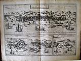
Mediterranean Ports: Cagliari, Malta, Rhodes & Famagusta.
 Cagler. Malte. Rodes. Famagosse. Calaris, Sardiniæ; Malta, olim Melita; Rhodus; Famagusta, civitas Cÿpri. Cologne G. von Kempen 1575
Black and white, copper engraved bird's eye views of Cagliari, Malta, Rhodes & Famagusta, 4 views on 1 plate, from the first volume of Braun & Hogenberg's Civitas Orbis Terrarum. French text to verso.
Set of four city plans, printed on a single sheet. Malta, Rhodes, Cagliari and Famagusta were all key strategic ports in the Mediterranean and in the cases of most of these, crucial sites in long conflict between Turkish and western forces. Famagusta, the principal port of Cyprus, had in 1571 just fallen to the Turkish Empire; Rhodes had been an important Hospitaller fortress, but had been held by the Turks since 1522. The remnants of the defenders retired to Malta, which is described as "the best known island of the Mediterranean Sea, which has a strongly fortified town of the same name, where in the year of 1565 the largest Turkish fleet was destroyed and the famous name was made immortal." , the capital of the Kingdom of Sardinia, was an important Spanish stronghold in the Western Mediterranean.
The bird's-eye view of Cagliari clearly shows the division of the city into four parts: the Castello district within the inner city wall, representing the original core, and the three partially walled suburbs of Stampax (Stampace) on the left, Gliapola facing the harbour and Nova Villa, the New Town on the right. Identified within Castello are the Gothic cathedral of Santa Maria di Castello (Bischoflich Kirch), the viceroy's palace (Kunigs Pallast) and the town hall (Rath Hauss). Founded in the 7th century BC, the city served as a major centre of commerce in antiquity. Later ravaged by pirates, in the 11th century Cagliari became part of the Kingdom of Aragon and the capital of the viceroyalty of Sardinia.
A schematic drawing shows Malta with a strongly fortified harbour. Fort St Elmo can be seen on the left, with Fort Sant'Angelo across the water to its right and the star-shaped Fort St Michael further right again. The town - indicated in the present plate - that grew up around Fort St Elmo is called Valetta: it was founded in 1566 by Jean Parisot de la Valette, Grand Master of the Order of St John. From 1530 until its conquest by Napoleontic troops in 1789, the island lay under the rule of the Knights Hospitaller, who hence also took the name of the Knights of Malta. Today Valletta is the capital of the Republic of Malta, which comprises the three islands of Malta, Gozo and Comino.
Rhodes is presented as a circular town with a well-fortifies harbour entrance. The town is surrounded by three impressive walls. The windmills just outside the harbour on the left are typical of Greek Islands. The city of Rhodes was designed c.408 BC by Hippodamus of miletus. The Colossus of Rhodes, which represented the Greek god Helios, patron saint of Rhodes, was erected between 292 and 280 BC and numbered amongst the Seven Wonders of the World. Following the division of the Roman Empire, Rhodes formed part of the Eastern Empire and came under the varying rule of Arab occupying forces and Crusaders. From the 16th century until 1912 it belonged to the Ottoman Empire.
The bird's-eye view shows the city of Famagusta surrounded by a double set of city walls and containing private houses and the church of St Nicholas. Famagusta was founded in antiquity under the name of Arsinoe (after Arsinoe II of Egypt) and in the Middle Ages developed into an important centre of trade, where business was transacted above all between Asia, Venice and Genoa. Its geographical location made the city an important strategic base for the Crusaders. In 1374 the Genoese occupied Famagusta and held it until 1571, when it was conquered by the Ottomans.[Taschen]. Good impression; light toning and soiling; light stain near title cartouche of Malta and near R of Rhodus and A of Famagusta.
Keoman 2; B&H 13, [plate 42]. 325 by 475mm (12¾ by 18¾ inches). Each plan 160x230mm €900
The Spice route:Portuguese Ports in Asia & Africa.
 Frans Hogenberg & Simon Novellanus`
Calicut, Ormuz, Kannur & the fort of St George, Elmina in Ghana "Calechut Celeberimum Indiæ Emporium. ", "Ormus", "Canonor", & " S. Georgii opid Mina". Cologne Theodori Graminæi. 1572
Frans Hogenberg & Simon Novellanus`
Calicut, Ormuz, Kannur & the fort of St George, Elmina in Ghana "Calechut Celeberimum Indiæ Emporium. ", "Ormus", "Canonor", & " S. Georgii opid Mina". Cologne Theodori Graminæi. 15724 copper engraved views of Portuguese ports and trading cities in India and Africa from the first volume of Braun & Hogenberg's "Civitas Orbis Terrarum. " Latin text to verso. First state.
The views are of Calicut in South West India, Ormuz on the Straits of Hormuz, : Kannur in Kerala, India; and the Portuguese fort of St George at Mina, now Elmina in Ghana. Good impression; some staining staining. light extensive waterstain to upper view of calicut.
Keoman vol2; B&H1/54 330 by 473mm (13 by 18½ inches). Calicut:182x473mm; the other 3 views approx:143x155mm each. €450
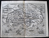
The Venetian Ports of Corfu and Candia.
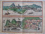 Frans Hogenberg & Simon Novellanus`
Candia & The City of Corfu. "Candia" & " La Cita de Corfu." Cologne G von Kempen? 1576
Frans Hogenberg & Simon Novellanus`
Candia & The City of Corfu. "Candia" & " La Cita de Corfu." Cologne G von Kempen? 15762 copper engraved views of the Venetian cities of Iraklion, Crete and Corfu from the second volume of Braun & Hogenberg's "Civitas Orbis Terrarum." German text to verso; original old colour; 2 views on 1 plate.
The upper view shows Iraklion known as "Candia" during the Venetian occupation seen from the sea with the castle and city walls, A fishing boat and galley to foreground.
The lower view of the Old Fort and town of Corfu/ Kerkyra ; The citadel topped by "old "and "new" castles and separated by a moat from the city; many venetian galleys in the port and surrounding sea; various areas identified including San Rocho and "El Bazzaro" now known as the Spianada . Dark impression; old colour; light toning; occasional spotting, one darker rust spot to upper right corner of Candia ,another to port of Corfu.[near to one of the moored galleys] and on the sea side lower right ; some smudges and soiling, mainly to blank margins; old tear to lower plate near centre fold, approx. 90mm, with old repair to verso; A few stains to blank verso.
Keoman vol2; B&H 8/53 370` by 486mm (14½ by 19¼ inches). Candia 175x486mm; Corfu 190x486mm. €1000
The 13 Cantons of the Old Swiss Confederacy.
 Frans Hogenberg & Simon Novellanus`
Cantons of Switzerland. "Decem et Tria Loca Confoederatorum Helvetiae. " Cologne Theodori Graminæi. 1572
Frans Hogenberg & Simon Novellanus`
Cantons of Switzerland. "Decem et Tria Loca Confoederatorum Helvetiae. " Cologne Theodori Graminæi. 157213 copper engraved views of the original 13 Cantons of the Swiss confederacy from the first volume of Braun & Hogenberg's "Civitas Orbis Terrarum. " Latin text to verso. First state. 13 views on 1 plate.
The views are: Suicia- Schwytz; Sylvania- Underwalden; Tugium-Zug; Glarona- Glaris; Basilea- Basell; Tygurum-Zurich; Civitas Ursina-Bern; Lucerna-Lucern; Ursella-Uri; Fiburgum- Fryburg; Civitas Soluterensis -Solothurn; Shaphusia- Schaffhussen; Appencella- Appenzell. Each gives the date of joining the confederacy. Good impression; a few light stains, mainly to blank margins; tear at lower centre fold [4cm]; red ink doodle to right margin.
View of Basle with full old colour; Glaris and Zurich with old col
Keoman vol2; B&H1/32 365 by 467mm (14¼ by 18½ inches). Each view in upper row approx 98x77mm; 2nd row 100x107mm; lower ro €450
Chios Town, Capital of the Island, North Aegean.
 Frans Hogenberg & Simon Novellanus`
Chios. "Chios Maris Aegæ ieiusdem nominis Insulae Civitas.." Cologne G von Kempen 1588
Frans Hogenberg & Simon Novellanus`
Chios. "Chios Maris Aegæ ieiusdem nominis Insulae Civitas.." Cologne G von Kempen 1588Copper engraved view of Chios from the fourth volume of Braun & Hogenberg's "Civitas Orbis Terrarum." Latin text to verso; black & white as issued.
The engraving shows the port and capital of Chios, seen from the east in a bird's-eye view. The town is represented as divided into the strongly fortified Byzantine Kastro and the town itself, which is defended on the landward side by massive watchtowers with a moat and a drawbridge.
Windmills line the coast; A canon fire s out to sea from a tower on the sea wall; numerous ships and galleys.
Decorative title cartouche
The city is often locally referred to as "Chora" (Χώρα; literally meaning "town") or "Kastro" (Κάστρο) to distinguish it from the entirety of the island with which it shares the name.
Originally the site of an ancient settlement, the town was first built at the north side of a natural harbour. By the 16th century, the walled town had been further fortified by successive rulers into a massive medieval castle, the "Kastro". Good Impression; occasional spotting , one dark above windmill in upper right; crease near centrefold; Map number reversed on verso 75 rather than 57.
Keoman vol2; B&H 4/57. 320 by 464mm (12½ by 18¼ inches). €1200
Company: Bryan, Mary Louise.
Address: Ag. Andrianoy 92 , 21 100 Nafplio, Greece.
Vat No: EL 119092581