MAPS & VIEWS
PRINTS
BOOKS
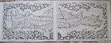
View of the Island of Philae.
 Île de Philae: "Vue desMonuments de L'Ile et des Montagbes de Granit qui Environnent." Paris Impremerie de C.L.F.Pancoucke 1820-1829
Copper engraved double page[ extended] view of Philae from volume I of the "Antiquities "of the "Description de l'Egypte," 2nd Edition; black & white, as issued; verso blank. Blind stamp of the publisher Panckoucke to margin.
The extra large and impressive plate [plate 4] shows the whole complex on the Island of Philae with the mountiains behind Good dark impression; some minor light spotting ,mainly to margins,occasionally within the plate; browning to second fold; traces of glue from tissue guard[ removed ]to left margin, far from image and to right margin.
Brunet:II, 617; Blackmer/Navari: 476 [1st edition] 495 by 1010mm (19½ by 39¾ inches). €1500
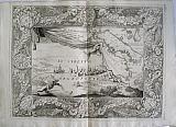
View of the Sphinx and Pyramids of Giza, at sunset.
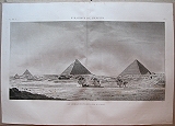 Pyramides de Memphis: "Vue Générale des Pyramides, prise du Sud-Est.." Paris Impremerie de C.L.F.Pancoucke 1820-1829
Copper engraved double page view of the Pyramids of Giza and the Sphinx from volume IV of the "Antiquities "of the "Description de l'Egypte," 2nd Edition; black & white, as issued; verso blank. Blind stamp of the publisher Panckoucke to margin.
The impressive plate [ plate 7]shows the Pyramids of Giza and the Sphinx. Good dark impression; some light spotting mainly to margins, a few within plate.
Brunet:II, 617; Blackmer/Navari: 476 [1st edition] 505 by 905mm (20 by 35¾ inches). €1500
View of the Sphinx and Pyramids of Giza, at sunset.
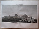 Pyramides de Memphis: "Vue Générale des Pyramides et du Sphinx. prise au soleil couchant." Paris Impremerie de C.L.F.Pancoucke 1820-1829
Copper engraved double page view of the Pyramids of Giza and the Sphinx from volume IV of the "Antiquities "of the "Description de l'Egypte," 2nd Edition; black & white, as issued; verso blank. Blind stamp of the publisher Panckoucke to margin.
The impressive plate [plate 8] shows the Pyramids of Giza and the Sphinx, at sunset, with various figures standing upon the head of the Sphinx taking measurements. Good dark impression; some minor light spotting mainly to margins, light foxing in places within the plate.
Brunet:II, 617; Blackmer/Navari: 476 [1st edition] 515 by 935mm (20¼ by 36¾ inches). €1500
View of the Thesion, Athens.
 Athens , View of the Temple of Theseus from the South West. "Athenes Vue du temple de These aspect Sud-Ouest." Lyon. Imprimerie de Louis Perrin 1858
Engraved view of the Thesion, Athens from Chenevard's "Voyage on Grece et dans le Levant fait en MDCCCXLVI." Hand coloured; verso blank.
The view shows the Thesion with the house of Plaka behind , in the distance can be seen the newly constructed Royal Palace ( completed in 1843), now the seat of the Greek Parliament. Generally clean,, smudges to upper blank margin within platemark but not image.
Blackmer/Navari:334; Blackmer/Sotheb's: 1109; Brunet:I, 1831. 263 by 405mm (10¼ by 16 inches). €150
The Acropolis of Athens.
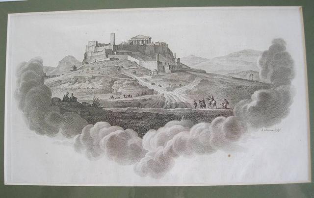 The Acropolis of Athens. The Acropolis of Athens. Paris J. J. Blaise 1782
Copper engraved vignette/ end piece from Choiseul- Gouffier's Voyage pittoresque de la Grèce. Black and white.
Designed as a chapter end piece and printed in the letterpress the view shows the Acropolis emerging from clouds; the venetian tower and lower walls are present; in the distance can be seen part of the temple of Olympian Zeus, & also the hill of Lycabettus. Black & white; one small spot outside image; under passepartout.
Blackmer/ Navari: 342; Atabey 241; 152 by 260mm (6 by 10¼ inches). €120
Choisuel-Gouffier's Magnificent 18th century Travel to Greece and the Coasts of Asia Minor.
 Voyage pittoresque de la Grèce. Voyage pittoresque de la Grèce. Tome premier. Paris J. J. Blaise 1782
Folio; Engraved allegorical title, [4] xvi (letterpress title) pp 204 . Directions to binder on rear paste down.
Full calf; spine gilt; 6 raised bands; labels.
With copper engraved vignette title, 13 maps, 2 of them folding, 32 full-page views, 27 sheets of half-page plates, maps and plans, 29 full-page plates (largely of architectural details), 4 costume illustrations on 1 sheet and 14 illustrative head- and tail-pieces. Tissue guards to plates.
First edition, first issue, (the Discours Préliminaireconcluding on the fourth line of page xvi.) of Choiseul-Gouffier's magnificent Voyage pittoresque de la Grèce .
Based on Choiseul Gouffier´s own account of his travel in 1776 as member of Marquis de Chabert´s expedition for mapping the Eastern Mediterranean. First Volume only, complete in itself, it would later be reissued with a second volume in two parts published in 1809 and 1822.
From Toulon, the French frigate Atalante sailed to Sardinia, Malta and Sicily, and put in at the port of Coroni. Then followed the islands of Cimolos, Melos, Siphnos, Sicinos, Ios, Santorini, Naxos, Tenos, Syros, Delos, Paros, Antiparos, Scyros, Lemnos, Lesbos, Chios, Samos, Patmos, Cos, Rhodes and Symi. The party then crossed over to Çesme opposite Chios, and Macre (pres. Fethiye), continuing their tour in western Asia Minor, visiting Telmessos, Mylassa, Stratonike, Bodrum-Halicarnassus, Iassos, Heraclea by Latmus, Didyma, Priene, Miletus, Ephesus, Teos and Smyrna.
The work was a considerable success and led to Choiseul- Gouffier's rise in cultural and political France culminating in 1784, when Choiseul-Gouffier was elected a member of the Académie Française and was appointed Ambassador of France to the Sublime Porte by Louis XVI, where he would remain until removed by the French revolutionary government in 1792 and went into exile in Russia where he would become director of the Academy of Arts and Imperial Library for Catherine the Great
Whilst ambassador to the Sublime Porte he used the opportunity to further his archeological and other researches with the aid of amongst others Louis François Cassas, J B Le Chevalier and Anse de Villoison.
Eventually returning to France from exile in 1802 he began work on the second, supplementary, volume which was published in two parts, the first in 1809, and the "final biographical livraison was published posthumously" in 1822. [Blackmer/ Navari] Some chipping of head cap and tail of spine; joints starting; corners bumped.
Tear to front free endpaper; candle wax to lower edge of allegorical title; light damp stain to lower gutter of chapter 6, pages 97-112. Very occasional minor spotting; page with plates 95 & 6 toned; small hole to margin of half plate 97, due to candle wax.
Blackmer/ Navari: 342; Atabey 241; 505 by 350mm (20 by 13¾ inches). €8000
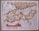
Iraklion, Crete.
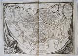 CORONELLI, Vincenzo Maria.
Candia, Town Plan. "Pianta Della real Fortezza,e Citta di Candia"with on verso "Castello di Candia". Venice CORONELLI, Vincenzo Maria. 1696
CORONELLI, Vincenzo Maria.
Candia, Town Plan. "Pianta Della real Fortezza,e Citta di Candia"with on verso "Castello di Candia". Venice CORONELLI, Vincenzo Maria. 1696Large double page copper engraved town plan of Candia/ Iraklion, Crete from CORONELLI's "Isolario descrittione geografico-historia... Tomo II dell' Atlante Veneto." Black & white; Italian text and half page plan of the Castle " Castello di Candia " to verso
The town plan which shows the full fortifications of the city of Candia, Iraklion.appears on a fringed drape suspended by Nails at the top; military and scientific instruments seen in the lower cornersas if on the floor of a military tent. Title cartouche of laurel leaves. Dark impression ; lower margin a little short. The plate cracked early in production and these faults can be seen printed on the map[ two dark "cracks" to left half and another just entering the cartouche these can be seen on the plan of the Castle on verso with due to the amount of ink which collected
Phillips 521. 450 by 616mm (17¾ by 24¼ inches).Castle plan:227 x 290mm. €750
Corfu with her Castles and Forts.
 CORONELLI, Vincenzo Maria.
Corfu/ Kerkyra "Isola di Corfu. Posseduta dalla serenisima Republica di Venetia...." Venice. CORONELLI, Vincenzo Maria. 1689-92
CORONELLI, Vincenzo Maria.
Corfu/ Kerkyra "Isola di Corfu. Posseduta dalla serenisima Republica di Venetia...." Venice. CORONELLI, Vincenzo Maria. 1689-92Large double page copper engraved map of Corfu/ Kerkyra from CORONELLI's "Corso Geographico Universale." of 1692. Black & white; verso blank.
The image shows the Island of Corfu/ Kerkyra and part of Paxos surrounded by vignettes within laurel wreathes of the most important castles of the island. 5 vignettes at the top show plans of C.de la Campana; Fortezza Nouvo; Citta di Corfu ; Fortezza Vechia; Castello S.Angelo. Below the island is a large title cartouche and 4 vignettes: plan of Castello a Mar; and views of: For. Nouva della partie Settentrione; Fortezza Vecchia & Cast.della Campana Extremely dark impression, bright and clean with wide margins; old ink number to verso
Zacharakis :1042/673; 470 by 620mm (18½ by 24½ inches). €1500
Vignettes of Forts, Ports and Islands of Crete.
 Fort of Torlulu; Fort of Agais Thodoroi.; Agais Thodoroi.; Beach of the Castle of Apicono;Island of Gavdos; Fort of Garabusa; Port of Marathi; View of the port of Suda; Port of Suda ; Port of Chania. "Fortezza di Torlulv; Fort di S.Teodoro; Sn. Todaro;Piaggio di Castel Apicorno nell isola di Candia; Isola di Gozzi di Candia; Fortezza di Carbusa; Porto di Marathi; Veduta del Porto della Suda ; Porto della Suda; Porto della Canea.." Venice. CORONELLI, Vincenzo Maria. 1696
Double page copper engraved sheet from CORONELLI's "Isolario descrittione geografico-historia... Tomo II dell' Atlante Veneto." Text to verso including vignette view of the port of Chania.
The sheet shows 9 vignettes of Forts, Ports and Islands of Crete. Each vignette has a plate number engraved within the plate. The plates also appeared in Coronelli's "Il Mediterraneo" [ 1688, 1707] and his " Citta, Fortezze, Porti et altri luoghi dei Regno & Isolaq di Candia"of 1706 Good Impression; small paper fault to left margin; pinprick worm holes to lower centrefold blank margin.
Zacharakis : 1108/742, 1109/743, 1113/747,1114/748. 135 by 172mm (5¼ by 6¾ inches) each vignette, overall page sizeincluding margins 500x690mm. €750
Coronelli's Description of the Morea in French.
 Historical & geographical memoirs of the kingdom of the Morea, Negrepont, and maritime places, as far as Thessalonica. Memoires Historiques & Geographiques du Royaume de la Moree, Negrepont & des places Maritimes Jusques à Thessalonique. Recueillis et enrichis des cartes des païs, et des plans des places Par P.M Coronelli, Geograph de la Republique de Venise.. Traduit de l'italien. Amsterdam Chez Woolfgang, Waesberge, Boon & van Sommern 1686
12mo: [4]-232-[2] pp.; with 42 double page, folded copper plates with maps, plans, views of Morea and Negroponte. Contemporary full calf; spine gilt, shelf label .
First edition printed in the Netherlands, with text in French and the plates again engraved, released in the same year of the two Italian editions in-folio and in-8 °.
This is a new translation prepared from the Italian text rather than being merely a reprint of the French translation by Barbin published in Paris in the same year It seems to have appeared in octavo only, and not in folio as with other editions. The plates were also newly engraved for this edition. 42 plates views and maps. Contemporary full calf; head cap missing; joints worn, corners bumped. Title, censored and laid down; First plate misbound, according to list of plates it should be the map of Morea instead swapped with plate 36 plan Le Port Lion; view of Modon; tear to view of Mistrawithout loss [repaired with archival tape to verso]; Map of Corfuwith tear without loss, at centre [repaired to verso with archival tape]; small hole to 2nd plate Napoli de Romanie; tear to margin p221 and lack of paper to upper margin just entering text.
Brunet II:287; -Blackmer, Sotheby's 1989, n° 72 (Ital. ed., 1687); -Atabey, Sotheby's 2002 n° 283 (Fr. ed., 1687); Weber 810. 160 by 100mm (6¼ by 4 inches). €3500
View of the Fort of Kalymnos, Dodecannesus.
 Island & Fort of Kalymnos "Isola e Forte di Calamo." Venice CORONELLI, Vincenzo Maria. 1696
Vignette viewof Kalymnos from CORONELLI's "Isolario descrittione geografico-historia... Tomo II dell' Atlante Veneto." Modern hand colour.
The view was one of the vignettes of Coronelli's "Isolario descrittione geografico-historia... Tomo II dell' Atlante Veneto." appearing within the text ; it also appeared in his work "Isola Di Rodi" published in 1688 & 1695. Good Impression.[ Mounted and handcoloured.]
125 by 164mm (5 by 6½ inches). €150
Famous decorative map of Crete.
 CORONELLI, Vincenzo Maria.
Island and Kingdom of Crete "Isola e regno di Candia..". Venice CORONELLI, Vincenzo Maria. 1696
CORONELLI, Vincenzo Maria.
Island and Kingdom of Crete "Isola e regno di Candia..". Venice CORONELLI, Vincenzo Maria. 1696Large copper engraved map of Crete from CORONELLI's "Isolario descrittione geografico-historia... Tomo II dell' Atlante Veneto." Black & white; 2 sheets; text to verso.
The island within awide garland of vines incorporating the names of 100 Cretan towns, coat-of-arms of Cardinal d' Estrées. Dark impression ; lower margin a little short. The plate cracked early in production and these faults can be seen printed on the map[ adark "crack" to left half near centrefold.
Zacharakis:1097/677Phillips 521. 467 by 615mm (18½ by 24¼ inches) each sheet. if joined the map is 467x1200mm €3200
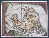
Kalymnos, Dodecannesus.
 Kalymnos. "Isola di Calamo nel Arcipel." Venice CORONELLI, Vincenzo Maria. 1696
Vignette map of Kalymnos from CORONELLI's "Isolario descrittione geografico-historia... Tomo II dell' Atlante Veneto." Modern hand colour.
The map was one of the vignettes of Coronelli's "Isolario descrittione geografico-historia... Tomo II dell' Atlante Veneto." appearing within the text ,; it also appeared in his work "Isola Di Rodi" published in 1688 & 1695.
The island is engraved upon a draped cloth. Good Impression.[ Mounted and handcoloured.]
Zacharakis :1134/695 125 by 164mm (5 by 6½ inches). €150
Corfu
 Kerkyra. "Isoladi Corfu" Venice CORONELLI, Vincenzo Maria. 1708
Copper engraved map of Corfu from CORONELLI's " Memorie istoriografiche de' regni della Morea ( ." Modern hand colour, verso blank. Good Impression. folds; mounted and hand coloured.
Zacharakis:1043/709. 132 by 175mm (5¼ by 7 inches). page size:173x235mm. €250
View of Kos, Dodecanesus.
 Kos. "Stanchio à Stango." Venice CORONELLI, Vincenzo Maria. 1696
Vignette view of Kos from Coronelli's "Isolario descrittione geografico-historia... Tomo II dell' Atlante Veneto." Modern hand colour.
The map was one of the vignettes of Coronelli's "Isolario descrittione geografico-historia... Tomo II dell' Atlante Veneto." appearing within the text ; it also appeared in his work "Isola Di Rodi" published in 1688 & 1695. Good Impression.[ Mounted and handcoloured.]
130 by 166mm (5 by 6½ inches). €150
Decorative map of Euboa,with a view of Chalkis.
 CORONELLI, Vincenzo Maria.
Map of Euboa with a view of Chalkis. "Regno di negroponte...". Venice CORONELLI, Vincenzo Maria. 1692-7
CORONELLI, Vincenzo Maria.
Map of Euboa with a view of Chalkis. "Regno di negroponte...". Venice CORONELLI, Vincenzo Maria. 1692-7Large double page copper engraved plate with a map of Euboa and view of Chalkis/ Negroponte from CORONELLI's "Corso Geographico Universale." of 1692. Black & white; verso blank.
The large decorative map is surrounded by an ornate baroque border. The map is engraved as if upon a drape or curtain, being held aloft by a putti to reveal a view of the city of Negroponte or Chalkida, showing the narrow straits with the castle. The Lion of Venice stands in the foreground.
Euboa was held by the Venetians and the Veronese after the Fourth Crusade with Chalcis in the hands of the Venetians, The island fell to the Ottomans in in 1470 after a long siege. As an important trade port for the Venetians they attempted to regain Negroponte in 1688 but were held off by the Ottomans. Dark impression on thick laid paper; 5 wormholes at centrefold and another top left close to edge of plate; printed slightly crooked on page hence upper margin short [approx. 3-10mm]; slight browning to centrefold due to glue of guard and browning to extreme edges.
Zacharakis; 1091/676. 460 by 610mm (18 by 24 inches). €1200
The Peloponnesus Conquered by the army of Venice.
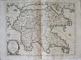 CORONELLI, Vincenzo Maria.
Peloponnesus today called Morea conquered by the Army of the Republic of Venice... "Peloponneso hoggidi Morea,Conquistata dall'Armi della Serenis, Repub. di Venezia, Descritta da Gio. Laurenberg...". Venice CORONELLI, Vincenzo Maria. 1692-7
CORONELLI, Vincenzo Maria.
Peloponnesus today called Morea conquered by the Army of the Republic of Venice... "Peloponneso hoggidi Morea,Conquistata dall'Armi della Serenis, Repub. di Venezia, Descritta da Gio. Laurenberg...". Venice CORONELLI, Vincenzo Maria. 1692-7Large double page copper engraved map of the Peloponessus after the description of Laurenberg from CORONELLI's "Corso Geographico Universale." of 1692. Black & white; verso blank.
The large decorative map celebrates the conquest of the Peloponnesus by the Venetiians . text of various victories appear beside important ports, for example "Navarin preso da Ven 1686" see also Modon, Coron Kalamata and Nafplion. Details of the recapture of Lepanto in 1687 and also of Athens the same year.
Title cartouche to lower left corner with long dedication to Fra Marcello Sachetti ambassador of Pope Innocent XI and with reference to the Hospitallers of St George of Jerusalem, the whole surrounded by a victory laurel wreath supported on a stone pedestal with lions feet. Dark impression on thick laid paper; 4 tiny wormholes at centrefold; wax stain to upper corners of engraved area.
Zacharakis; 1082/675. 460 by 614mm (18 by 24¼ inches). €750
Scarce Miniature Sea Chart of Kefalonia, Zakynthos and Part of the Peloponnesus.
 Sea Chart of Kefalonia, Zakynthos and Part of the Peloponnesus. "Partie Meridionle della Cefalonia, e Morea, e Isola del Zantel." Venice. CORONELLI, Vincenzo Maria. c1708
Copper engraved miniature sea chart showing part of Kefalonia the morea and the island of Zakynthos from CORONELLI's" Morea, Negreponte e Adiacenze" Black & white; verso blank.
Scarce miniature sea chart, rhumb lines and small shields to islands.
The Morea, Negreponte e Adiacenze includes the plates from the fifth volume (titled "Repubblica di Venezia") of the fourth part of "Teatro della Guerra", a work which Coronelli planned to publish. The project was intended as a series of representative plates, related to the countries which fought in the War of Spanish Succession (1701-1713), and was destined for the members of the Accademia Cosmografica degli Argonauti. In the end, the edition did not materialize. However, some parts thereof were released in copies disctinct from each other, as each included a different number of plates. Good Impression; evenly toned; light dampstain to upper and right blank margin.
Zacharakis :1068. 129 by 183mm (5 by 7¼ inches). €300
Tilos, Dodecanesus.
 Tilos. "Isola di Piscopia." Venice CORONELLI, Vincenzo Maria. 1696
Vignette map of Tilos from Coronelli's "Isolario descrittione geografico-historia... Tomo II dell' Atlante Veneto." Modern hand colour.
The map was one of the vignettes of Coronelli's "Isolario descrittione geografico-historia... Tomo II dell' Atlante Veneto." appearing within the text ; it also appeared in his work "Isola Di Rodi" published in 1688 & 1695.
The island is engraved upon a draped cloth. Good Impression.[ Mounted and handcoloured.]
Zacharakis :1131/692 124 by 163mm (5 by 6½ inches). €150
The Americas.
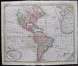 America Accurate in Imperia, Regna, Staus & Populos Divisia, ad Usum Ludovici XV Galliarum Regis. Carte d'Amerique.
Amsterdam. Covens et Mortier c1741
Copper engraved map of of the Americas from Covens & Mortier's " Nieuwe Atlas, Inhoudennde vier Gedeeltens der Waereld.. " Original full wash colour; verso blank.
Black and white strap work title cartouche [as issued]."Avertisement" on black & white drape to lower right corner
The map after Guillaume De l'Isle's shows the whole continent, with part of Europe and Africa to the East. The map includes a Prime Meridian declared by Louis XIII and Pope Alexander VI's Line of Demarcation that divided the world (outside of Europe) between Portugal and Spain. Includes detailed information about discoveries and explorations particularly around the Magellan strait and the discovery of the Falkland islands in 1706. Dark impression; bright full wash colour; printed on heavy paper, short centre fold split at lower margin with old repair to verso and lower margin; old red crayon numbers to verso.
Koeman I: C&M 8:103. 510 by 615mm (20 by 24¼ inches). €1200
The Continent of Asia.
 Asia Accurate in Imperia , Regna Staus & Populos Divisia, ad Usum Ludovici XV Galliarum Regis. Carte d'Asie.
Amsterdam. Covens et Mortier c1741
Copper engraved map of Asia from Covens & Mortier's " Nieuwe Atlas, Inhoudennde vier Gedeeltens der Waereld.. " Original full wash colour; verso blank.
Black and white strap work title cartouche [as issued].
The map after Guillaume De l'Isle's shows the whole continent, with part of Europe and Africa to the West across to the Pacific in the East.
Inset to upper right corner of Irkut.province. Dark impression; bright full wash colour; printed on heavy paper, short centre fold split at lower margin with old repair to verso and lower margin; old red crayon numbers to verso.
Koeman I: C&M 8:84, [C&M 10] 500 by 620mm (19¾ by 24½ inches). €650
Tuscany and the Church States in 2 Sheets.
 Estat du Grand duc de Toscane & Estates de L'Eglise Estats de L'Eglise et de Toscane.
Amsterdam. Covens et Mortier c1741
Copper engraved map on 2 sheets of the Church States and Tuscany from Covens & Mortier's " Nieuwe Atlas, Inhoudennde vier Gedeeltens der Waereld.. " Original full wash colour; verso blank.
The large map shows printed on 2 sheets shows Central Italy with her islands Capri, Elba &c and part of Corsica.
Large decorative title cartouche to right sheet; scale to left sheet. [ further scale printed to bank margin of right sheet ] with title above. Dark impression; bright full wash colour; printed on heavy paper; light toning; damp stain to upper and lower right corners of both sheets.
Koeman I: C&M 11: (92),88. 556 by 446mm (22 by 17½ inches). each sheet. total map if joined 556x 892mm. €700
Saint Domingo, Hispaniola.
 Insulæ S, Dominicæ Tabula Accuraetissima. Carte de l'Isle de Saint Domingue Dressee en 1722 pour l'usage du Roy sur les memoires de Mr. Frezier Ingenieur de S.M. et autres assujettis aux Observations Astronomiques ..
Amsterdam. Covens et Mortier Dated 1722 to cartouche but c1741
Copper engraved map or chart of of the island of Hispaniola showing St. Domingo from Covens & Mortier's " Nieuwe Atlas, Inhoudennde vier Gedeeltens der Waereld.. " Original full wash colour; verso blank.
Black and white strap work title cartouche [as issued].
The map after Guillaume De l'Isle shows the whole island in detail; the Western half [ now Haiti was ] taken by the French in 1659, whilst the Eastern half remained Hispaniola under the control of the Spanish, [ now the Dominican Republic].
Saint-Domingue was a French colony on the Caribbean island of Hispaniola from 1659 to 1804. The French mainly Buccaneers had established themselves on the western portion of the islands of Hispaniola and Tortuga by 1659. In the Treaty of Ryswick of 1697, Spain formally recognized French control of Tortuga island and the western third of the island of Hispaniola.
The map also shows the Eastern tip of Cuba and the nearby islands; with borders indicated between. 2 compass roses and rhumb lines have been added making it more of a sea chart. Dark impression; bright full wash colour; printed on heavy paper; old red crayon numbers to verso.
Koeman I: C&M 8:116. 515 by 627mm (20¼ by 24¾ inches). €600
The Duchy of Milan.
 Le Duche de Milan dans touts son Estendue, divisé en ses Principales Partes, avec les Estates et Frontieres qui L'Environment Le Duche de Milan dans touts son Estendue, divisée en ses Principales Partes, avec les Estates et Frontieres qui l'environment...
Amsterdam. Covens et Mortier c1741
Copper engraved map of the Duchy of Milan from Covens & Mortier's " Nieuwe Atlas, Inhoudennde vier Gedeeltens der Waereld.. " Original full wash colour; verso blank.
The large map shows the full extent of the Duchy of Milan. It appears to be a reworking of de Wit's map of the same area, with a different title.
Decorative title cartouche and scale. Dark impression; bright full wash colour; printed on heavy paper; light toning; light damp stain to upper left corner, entering plate. Upper margin and title shaved, lower margin shaved to plate mark. Paper extended to left and extra fold to fit in atlas.
Koeman I: C&M 535 by 682mm (21 by 26¾ inches). €450
The Balearic Islands.
 Majorca, Minorca, Ibiza and Formentera, Carte des Isles Maiorque, Minorque et Yvice.
Amsterdam. Covens et Mortier c1741
Copper engraved map of the Balearic Islands after Bellin from Covens & Mortier's " Nieuwe Atlas, Inhoudennde vier Gedeeltens der Waereld.. " Original full wash colour; verso blank.
The map shows all four islands with insets to lower right showing the Port of Mahon :Plan du Port et de la Ville de Mahon et des forts and a small map showing the position of the Islands off the coast of Spain.
Decorative cartouche to upper left with scale below and compass rose to sea. Dark impression; bright full wash colour; printed on heavy paper,
Koeman I: C&M 8:68, [C&M 10 & 11] 420 by 580mm (16½ by 22¾ inches). €700
Martinique.
 Martinique. Carte de l'Isle de la Martinique Colonie Françoise de l'une des Isles Antilles de l'Amerique..
Amsterdam. Covens et Mortier c1741
Copper engraved map or chart of of the island of Martinique from Covens & Mortier's " Nieuwe Atlas, Inhoudennde vier Gedeeltens der Waereld.. " Original full wash colour; verso blank.
Black and white strap work descritive key cartouche [as issued].
The map after Guillaume De l'Isle and Phillippe BUACHE shows the island divided into 3 areas, by different colours , representing the 3 different religious orders: the Dominicans to the North [ yellow] with the port of La Trinité ; the Capuchins to the South East [pink] with the town and Fort of St. Pierre and the Jesuits to the West [green] with Fort Royale. 2 compass roses and rhumb lines . Dark impression; bright full wash colour; printed on heavy paper; light soiling; old red crayon numbers to verso.
Koeman I: C&M 8:118. 480 by 600mm (19 by 23½ inches). €500
Italy.
 Nova Italæ Descriptio, in Regna, Respublicas et Status Divisæ.. Ad usum Serenissimi Burgundiæ Ducis. L'Italie.
Amsterdam. Covens et Mortier c1741
Copper engraved map of Italy from Covens & Mortier's " Nieuwe Atlas, Inhoudennde vier Gedeeltens der Waereld.. " Original full wash colour; verso blank.
The map shows the whole peninsular of Italy with the coast of Dalmatia, the islands of Corsica, Sardinia and Sicily, with part of the coast of Tunisia and Algeria.
Decorative title cartouche and scale. Dark impression; bright full wash colour; printed on heavy paper; light stain to upper left and right corners of blank margins.
Koeman I: C&M 8:69, [C&M 10] 502 by 601mm (19¾ by 23¾ inches). €500
The Iberian Peninsular.
 Nova regni Hispaniæ accurata descriptio, ad Usum Serenissimi Burgundiæ Ducis. Authore G de L'Isle Geographe. L'Espagne Dressées sur la Descriptionqui en a eté faite par Rodrigo Mendez Sylva..
Amsterdam. Covens et Mortier c1741
Copper engraved map of the Iberian Peninsular from Covens & Mortier's " Nieuwe Atlas, Inhoudennde vier Gedeeltens der Waereld.. " Original full wash colour; verso blank.
The map after Guillaume De l'Isle shows the Iberian peninsular divided into Kingdoms, with the Balearic islands, extending into France in the North and with the straits of Gibraltar and the coast of North Africa to the South.
Decorative title cartouche to upper right and scale to lower left. Title in Latin above. Dark impression; bright full wash colour; printed on heavy paper,
Koeman I: C&M 8:67, [C&M 10] 495 by 600mm (19½ by 23½ inches). €350
Piedmont and Montferrat in 2 Sheets.
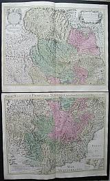 Piedmont & Montferrat. Carte du Piemont et du Monferrat Dressée sur plusieurs Cartes, Manuscrites ou Imprimées ... Par Guillaume De l'Isle
[ Partie Meridionale du Piemont et Monferrat. Par Guilliame De l'Isle de l'Academie Royales des Sciences] Amsterdam. Covens et Mortier c1741
Copper engraved map on 2 sheets of Piedmont & Monferrat from Covens & Mortier's " Nieuwe Atlas, Inhoudennde vier Gedeeltens der Waereld.. " Original full wash colour; verso blank.
Decorative title cartouche and strapwork cartouche to Advertisement with scale below to upper sheet; Lower sheet with additional title to upper blank margin; scale to lower left ; Inset plan of environs of Nice to lower right. Dark impression; bright full wash colour; printed on heavy paper; light toning;
Koeman I: C&M 8:70,71. 485 by 635mm (19 by 25 inches). lower sheet: 501x635mm. €800
Sicily.
 Sicily & Malta. Carte du de L'Isle et Royaume de Sicilie. Par Guilliame De l'Isle de l'Academie Rle. des Sciences.
Carte Particuliere de L'Isle de MaLTE ET DES iSLES vOISINNES Amsterdam. Covens et Mortier c1741
Copper engraved map of Sicily from Covens & Mortier's " Nieuwe Atlas, Inhoudennde vier Gedeeltens der Waereld.. " Original full wash colour; verso blank.
The map shows the Island of Sicily with inset map of Malta and Gozo to lower left Dark impression; bright full wash colour; printed on heavy paper; light toning; light damp stain to upper corners just touching printed area; light spot to lower blank margin.
Koeman I: C&M8:77. 485 by 587mm (19 by 23 inches). €650
Company: Bryan, Mary Louise.
Address: Ag. Andrianoy 92 , 21 100 Nafplio, Greece.
Vat No: EL 119092581