MAPS & VIEWS
PRINTS
BOOKS
The Globe-flowered Protea of South Africa.
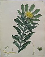 The Globe-flowered Protea. "Protea globosa." London: Printed by T. Bensley, and published by the author, No 5 Knightsbridge. 1797-1815
Original coloured engraving of the Globe-flowered Protea from Henry Andrew's " The Botanist's Repository, for New, and Rare Plants". Dated 1803.
The plate shows the Globe-flowered Protea a native of South Africa. Printed in black and coloured by hand by Andrews.
Haworth (ESTC); Dunthorne 8, Nissen 2382. 267 by 210mm (10½ by 8¼ inches). €40
The Gigantic Swallow-wort, or Auricula tree of the East & West Indies.
 The Gigantic Swallow-wort or Auricula tree. "Asclepias gigantea." London: Printed by T. Bensley, and published by the author, No 5 Knightsbridge. 1797-1815
Original coloured engraving of the Gigantic Swallow-wort or Auricula tree from Henry Andrew's " The Botanist's Repository, for New, and Rare Plants". Dated 1803.
The plate shows the Gigantic Swallow-wort or Auricula tree a native of the East & West Indies. Printed in black and coloured by hand by Andrews; lightly toned; some light offset from text; light damp drop at upper edge.
Haworth (ESTC); Dunthorne 8, Nissen 2382. 267 by 210mm (10½ by 8¼ inches). €100
First Complete Edition in Greek of Appian's Roman History.
 ΑΠΠΙΑΝΟΥ ΑΛΕΞΑΝΔΡΕΟΣ ΡΟΜΑΙΚΑ. Appiani Alexandrini Rom. Historiarum, Punica, sive Carthaginensis, Syriaca, Parthica, Mithridatica, Iberica, Annibalica, Celtica et Illyricae fragmenta quaedam. Item De bellis civilibus libri V. Henr. Steph. Annotationes Geneva. Exudebat Henricus Stephanus 1592
Folio. pp [12] x. 767.72. [34].. Title and text in Greek and Latin, woodcut device on title, with the final blank 17th-century Dutch vellum, red leather gilt label on spine, large blind-stamped arabesque on sides.
Second, but first complete, edition in Greek of Appian's history of Rome's wars, external and civil, from the first Punic War until the death of Pompey. The Editio princeps published in 1551 did not include Iberico and Aniibalica as they were unknown at the time. Important also for Stephanus' Annotationes Piece of vellum missing from head of spine, upper joint cracking.
Light toning and some scattered spotting; light damp stain to lower edges of pp1-428 far from text; lower corner lost p433; dampstain to lower corner of second part; Annotationesand index. otherwise generally crisp and clean.
Adams A1340; Hoffmann I, 214; Mortimer French 29; Schreiber 126. 360 by 240mm (14¼ by 9½ inches). €1850
"Édition Très Estimée " of Aristophanes' Comedies.
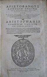 ΑΡΙΣΤΟΦΑΝΟΥΣ ΚΟΜΟΔΙΑΙ ΕΝΔΕ Aristophanis Comoediae vndecim cvm scholiis antiqvis quæ studio & opera nobilis viri Odoardi Biseti Carlæi sunt quamplurimis locis accuratè emendata, & perpetuis nouis scholiis illustrata. Ad quæ etiam accesserunt eiusdem in duas posteriores noui commentarij: operâ tamen & studio doctissimi viri d. Æylij Francisci Porti Cretensis filij ex Biseti autographo exscripti & in ordinem digesti Aureliae Allobrogum- Geneva Sumptibus Caldorianae Societatis. 1607
Folio; pp [36], 916, [28] Full contemporary vellum, title in ink to spine. Parallel Greek and Latin text in two columns, .with scholia of Biseti, Gerardus &c
"Très estimée" edition of Aristophanes' Eleven Comedies. Brunet and Graesse consider this the most correct text. The Latin translation is made form the versions of Frischlin, Flor. Chrestien and Andr. Divus.
Greek scholia beneath text, with the exception of Σφηκεσ(The Wasps) Πλουτοσ(Wealth) & Ειρηνη(Peace) where there is also Latin scholia. Spotting and toning throughout due to quality of paper. Worm track to last page of index and rear endpapers.
Under linings and annotations to margins in red crayon mainly to the Latin scholia of Σφηκεσ,(The Wasps)Πλουτοσ(Wealth) & Ειρηνη (Peace).
Brunet:1,452-3; Graesse:1, 206-7. 355 by 230mm (14 by 9 inches). €1500
Tyrwhitt's Rrecension of Aristotle's Poetics.
 ΑΡΙΣΤΟΤΕΛΟΥΣ ΠΕΡΙ ΠΙΗΤΙΚΗΣ. Aristotelis De poetica liber : Græce et Latine. / Lectionem constituit, versionem refinxit, animadversionibus illustravit Thomas Tyrwhitt. Oxonii/Oxford E Typographeo Clarendoniano. 1794
Large paper Octavo; xvi, 257, [3] p. engraved tail pieces.
The beautiful clear Greek text printed with the Latin translation below followed by the commentary by Tyrwhitt.
First edition of the outstanding recension by Thomas Tyrwhitt (1730-1786). "His Poetics was the first modern edition of the text." (Barker)
Graesse: "édition estimée".Brunet " Belle édition.."
"This is a very elegant and accurate edition, containing the commentaries of Tyrwhitt, as well as his version ... The Greek text is formed on that of Winstanley, but so carefully corrected, as to leave not a single error unnoticed ... The large paper copies of this volume form one of the most attractive ornaments of a classical collection. They are few in number, and costly in price; being reserved by the Delegates of the University Press as presents for eminent characters. I understand that 34 copies have been already distributed ... This edition has been several times reprinted at Oxford, with only three alterations, and those not important ones." Dibdin I, 323 Rebacked, original boards diced calf with Greek key in gilt; marbled endpapers. Old ink annotation to front free end paper quoting Dibden; owners name clipped.
Large paper copy clean and bright.
Brunet 1:478; Graesse I,214 ;Barker, Oxford Univ. Press 167. - Dibdin I, 323. 300 by 240mm (11¾ by 9½ inches). €900
Arrian's Description of the Circumnavigation of the Black Sea.
 Peripilus Ponti Euxini & Maris Erthræi. Historici et Philosophi Ponti Euxini & Maris Erythræi Periplus, ad Adrianum Caesarem.. Genevæ- Geneva/ Lugduni- Lyon Euststhium Vignon / Bartholemæum Vincentium. 1577
[4] map[8] pp109 [12.]Blank; &: [8][10] pp109 [2][6].
First separate edition of works attributed to Arrian of Nicodemia which appeared simultaneously at Geneva and Lyons in 1577 with the translation and commentary of Johann Wilhem Stucki.
This example has the Geneva imprint of the Ponti Euxiniand the Lyons imprint of the Maris Erythræi. The texts of both works were first published by Froben in 1533 in the anthology Arriani & Hannonis periplus. Plutarchus de fluminibus & montibus. Strabonis epitome.
The woodcut map of the Black Sea is the first printed map of the sea, it is decorated with ships, monsters and mermen.
The Peripilus Ponti Euxini takes the form of a letter, from Arrian to the Emperor Hadrian in Rome, who was particularly attached to geographical research and had visited in person a large portion of his extensive dominions. It contains an accurate topographical survey of the coasts of the Euxine (Black Sea), from Trapezus to Byzantium, and was written probably while Arrian held his office of legate of Cappadocia, a short time before war broke out against the Alani; and it was doubtless at the same time that he drew up his instructions for the march of the Roman army against the barbarians, which are found in a short but imperfect fragment annexed to the Techne Taktika, written, as he states himself, in the twentieth year of the reign of the emperor, and containing, after a brief account of former writers on the same subject, a description of the order and arrangement of an army in general.
Its purpose was to inform the emperor of the "lay of the land" and provide him with necessary information such as the distances between cities and the locations that would provide safe harbor for ships in a storm in the eventuality that Hadrian should mount a military expedition to the region.
According to Gibbon's epigrammatic expression in his 42nd chapter, the Peripluscontains "whatever the governor of Cappadocia had seen from Trebizond to Dioscurias; whatever he had heard, from Dioscurias to the Danube; and whatever he knew, from the Danube to Trebizond." Thus, while Arrian gives much information upon the south and east side of the Euxine, in going round the north shore his intervals become greater, and his measurements less precise.
The second work the Periplus Maris Erythræi though for many years attributed to Arrian is now believed to be by an unknown author. The text has been ascribed to different dates between the 1st and 3rd centuries AD, but a mid-1st century date is now the most commonly accepted. A Greco-Roman periplus, written in Greek, describing navigation and trading opportunities from Roman Egyptian ports like Berenice along the coast of the Red Sea, and others along Northeast Africa and the Sindh and South western India, it is clearly a firsthand description by someone familiar with the area and is nearly unique in providing accurate insights into what the ancient European world knew about the lands around the Indian Ocean.
One historical analysis, published by Schoff in 1912, narrowed the date of the text to 60 AD Though redating the document from 1912 to a single year roughly 2000 years earlier might be considered remarkable by modern standards, a date of 60 AD nevertheless remains in perfect agreement with present-day estimates of the middle of the 1st century AD .Schoff additionally provides an historical analysis as to the text's original authorship,and arrives at the conclusion that the author must have been a "Greek in Egypt, a Roman subject." By Schoff's calculations, this would have been during the time of Tiberius Claudius Balbilus (who coincidentally also was an Egyptian Greek).
John Hill maintains that the "Periplus can now be confidently dated to between 40 and 70 AD and, probably, between AD 40 and 50."
Schoff continues by noting that the author could not have been "a highly educated man" as "is evident from his frequent confusion of Greek and Latin words and his clumsy and sometimes ungrammatical constructions." Because of "the absence of any account of the journey up the Nile and across the desert from Coptos," Schoff prefers to pinpoint the author's residence to "Berenice rather than Alexandria." Though Schoff is unclear about which of several Berenices he is referring to, it is actually Berenice Troglodytica which is documented, discussed at length and vividly described within the periplus text itself.
One peculiarity noted by Schoff while translating from the original Greek version is that "the text is so vague and uncertain that [the author] seems rather to be quoting from someone else, unless indeed much of this part of the work has been lost in copying." First printed woodcut map of the Black sea; folded. Contemporary vellum; blindstamped gilt to spine; title in ink. Ex Libris of R.H. Robbins to pastedown.
Decorative printer's mark to titles. Folding double page woodcut map.
Light toning to Part 1; waterstain to lower gutter p187 to p47 of second work, lightening and reappearing p69 to end. Pages 25-41 of second work with spotting, index toned. rear internal hinge starting.
Graesse1 p228; Brunet 1 p497;Adams A 2016. 320 by 205mm (12½ by 8 inches). €3500
Voyage du Jeune Anacharsiswith large folding map by Barbie de Bocage appearing for the First time.
 Travels of Anacharsis the Younger in Greece. Voyage du Jeune Anacharsis en Grèce, vers le mileu du Quatrième Siècle avant l'Ère Vulgaire.. Paris chez Desray, Libraire, rue haute-Feuille, No4 de l'Imprimerie de Didot le Jeune. 1817
7 Volumes Octavo; [clii] 367; Half title, volume title [ii] 517 (518); [vi. including titles],496; [vi. including titles] 507 (508); [vi. including titles] 495 (496); half title, volume title, table of contents,454; [vi. including titles]496.
& Atlas in Folio pp 60+1. with 41 copper engraved plates. 5th edition Text uncut. Blue boards with gilt to spines.
A matching set of the 1817, 5th edition of Barthelemy's famous Voyage du jeune Anarcharsis en Grèce, first published in 1787.
The atlas volume in large folio includes the large folding map Carte Générale de la Grèce et d'une grande partie de ses colonies..by Barbie de Bocage, for the first time. Originally intended to appear in the edition of An VII[1798-9] as the text of the edition mentions however there were "difficulties du libraire" as Bocage mentions in his Addition critique des cartes de l'Ancienne Grèce [1811] As can be seen from the dates on the cartouche the map was finally finished in 1811 it was only when Didot Jeune again published the atlas in large folio for the 5th edition in 1817 that this decorative map engraved by PAF Tardieu could finally be published. Also includes the double page map of the same title that was included in previous editions. Portrait of the JJ.Barthelemy in Vol 1 of text
Atlas: Large portrait by F.P. Gounod. Carte Générale de la Grèce et d'une grande partie de ses colonies..by Barbie de Bocage, and 12 maps of parts of Greece with outline colour; 15 maps and plans of ancient Greek sites and battles in black and white, including Marathon, Thermopylea and Salamis, also the Bosphorus, Hellespont and Black Sea..
Architectural restorations of ancient temples, floor plans of buildings and copper engraved views of the Parthenon, Thesion, Sunium and Delphi. A plate of coins with page of explanation. All but the large map and plate 2bis [ the general map of Greece that had appeared in previous editions] unfolded single page plates, with good margins Text: Spine of Vol 5 & boards of most volumes rubbed. Corners and head and tails of spines bumped; Vol. 2-7 pages uncut, heavy spotting throughout.
Atlas: spine and boards rubbed; damp stain to front board; lower corners heavily bumped; chip to edge of rear board.
Plates: Large folding map of Greece by Barbie de Bocage with light spotting mainly to margins; some spotting throughout. mainly away from images.
Brunet:1,674-675; not in Zacharakis, but see note under Barbie de Bocage. 220 by 135mm (8¾ by 5¼ inches)Text volumes; Atlas:480 by 310mm (19 by 12¼inches). Map: 535 by767mm ( €2000
Anacharsis Atlas.
 Atlas to the "Travels of Anacharsis the Younger in Greece." Recuil de Cartes géographiques, plans vues et medailles de L'Ancienne Grèce, relatifs au Voyage du Jeune Anacharsis en Grèce, précédé d'une analyse critiques des cartes. Paris de l'Imprimerie de Didot le Jeune L'An Septième [1798-9]
Folio; 56+1 and 39 copper engraved plates. Half calf over marbled boards; 4 raised bands;labels in black and gilt.; Marbled end papers.
Atlas to accompany Barthelemy's famous Voyage du jeune Anarcharsis en Grèce, first published in 1787. Nouvelle Edition.
The atlas volume in large folio does NOT includes the large folding map Carte Générale de la Grèce et d'une grande partie de ses colonies..by Barbie de Bocage, called for in the list of contents. The new map was originally intended to appear in this edition of An VII [1798-9] but as Bocage mentions in his Addition critique des cartes de l'Ancienne Grèce [1811] there were "difficulties du libraire"; the map was finally ready in 1811 and did not appear till the 5th edition of 1817.
Starts with plate 2 the double page map of the same title. Double page map of Greece and 11 maps of parts of Greece with outline colour; 15 maps and plans of ancient Greek sites and battles in black and white, including Marathon,Thermopylea and Salamis, also the Bosphorus, Hellespont and Black Sea..
Architectural restorations of ancient temples, floor plans of buildings and copper engraved views of the Parthenon, Thesion, Sunium and Delphi. A plate of coins with page of explanation. Unfolded single page plates, with good margins Joints rubbed.; corners bumped.
Front free endpapers with some spotting but plates generally very clean and bright throughout, though there is a damp stain to lower gutter, it is mainly far from image.
Brunet:1,674-675; not in Zacharakis, but see note under Barbie de Bocage. 480 by 310mm (19 by 12¼ inches). €1000
Scarce Ornamental View of Iraklion.
 Candia, Capital of the Kingdom " Candie, Capitalle du Royaume." Paris chez l'Autheur. without date. [1667-1694].
Copper engraved panaoramic view of Iraklion from "Les Glorieuses Conquetes de Louis de Grand.." Modern colour; verso blank.
The impressive view of Iraklion is surrounded by a decorative faux frame. Printed from two copper plates the upper half has an ornate garland with swags of leaves suspending an empty locket/frame [a portrait of Louis XIV was intended to be within the frame with his coat of arms suspended below from the small brass ring].
In the lower half a view of Iraklion from the sea with a key below to important edifices within the city. Good Impression, printed on thick laid paper; minor spotting, mainly to blank margins, a couple within the image; two short tears to right edge. {repaired with archival tape to verso].
see Zacharakis:246/135, for details of the map from the same work. 459 by 560mm (18 by 22 inches). €1100
Scarce Map of the Peloponnesus.
 Jean Appier Hanzelet, of Lorraine,
Peloponnesus. "Moree." Nancy Jacob Garnich. 1615,1619
Jean Appier Hanzelet, of Lorraine,
Peloponnesus. "Moree." Nancy Jacob Garnich. 1615,1619Copper engraved map of the Peloponnesus from Beauveu's "Relation Journalière du voyage du Levant". Black & white, set above key and text; text to verso.
The finely engraved map shows the whole of the Peloponnesus and the surrounding islands including the coast of continental Greece, the gulf of Corinth, the Saronic gulf, Attica and some of the islands of the Archipelago.
the key identifies numbers engraved within the map, mainly the islands but also Athens, Sunium and Lepanto. Dark impression, including ink spot within sea.
Zacharakis:251/140; Atabey 85; this edition not in Blackmer (cf. 106 for first illustrated edition); Brunet I.724 (s.v Beauveau) 102 by 153mm (4 by 6 inches). €500
Company: Bryan, Mary Louise.
Address: Ag. Andrianoy 92 , 21 100 Nafplio, Greece.
Vat No: EL 119092581