Cartographic Curiosity: the Houses of Braunschweig, Lunenburg and the House of Stuart
SEUTTER MATTHÄUS
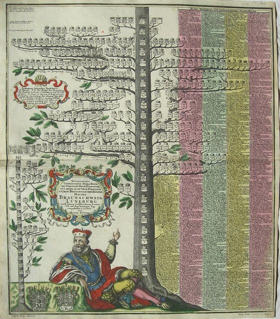
Genealogical tree of Braunschweig & Lunenburg, and the House of Stuart of Great Britain. "
Neu inventierter Genealogisch. Stam Baum des Uhrhalten Hoch Fürstlich. nun mehr. auch Fürstlich u. Gross Brittanischen Königl Hauses Braunschweig Lünenburg...." Augsburg SEUTTER MATTHÄUS 1734
Copper engraved genealogical plate by Matthaus Seutter from his
" Grosser Atlas," Original full colour; verso blank.
The image shows a Genealogical tree with a King reclining below; to the left a small tree of the House of Stuart. Seutter shows how the families became linked so that a German became King of Great Britain.
Decorative title cartouche, black and white as issued; two heraldic coats of arms. Dark impression; Damage at centrefold where adhesion had caused a tear repaired; light foxing in places.
Matthäus Seutter 1(647 –1756)
One of the most important and prolific German map publishers of the 18th century, engraver, globe-maker and publisher.
Born in Augsburg in 1685, the son of a goldsmith. Seutter began his studies in Nuremberg in 1697, apprenticed as an engraver to Johann Baptist Homann. in 1707 later he returned to Augsburg subsequently working in the publishing house of Jeremias Wolff in the city. He founded the Seutter publishing house and print shop in 1710, producing maps, atlases, and globes., which became a primary competitor to Homann. By 1732 Seutter was one of the most prolific publishers of his time and was honored by the German Emperor Charles VI with the title of "Imperial Geographer". Seutter continued to publish until his death, at the height of his career, in 1757.
Very few original maps were printed there, as Augsburg at that time had no university and none of the necessary connections to the fields of mathematics or the natural sciences. Therefore Seutter copied the work of other cartographers, making his own engravings based on their models (approximately 500 pieces).
His "
Atlas Geographicus oder Accurate Vorstellung der ganzen Welt' appeared in 1725 with 46 maps: the "
Atlas Novus" various editions in 1728, 1730, 1736, 1742; the "
Grosser Atlas"in 1734 with 131 maps, and the pocket atlas "
Atlas minor in 1744 with 64 maps.
After Matthäus Seutter died in 1757, his son, Albrecht Karl, his son-in-law Conrad Tobias Lotter, and his business partner Johann Michael Probst ran the business for five more years.
580 by 520mm (22¾ by 20½ inches).
ref: 2047
€600