MAPS & VIEWS
PRINTS
BOOKS
back to search results place the mouse over an image to zoom
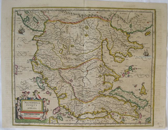
Macedonia, Epirus and Achaia.
Mercator, Gerhard . Macadonien, Epirus und Achaia. "Macedonia, Epirus and Achaia." Amsterdam Janssonius, Jan 1649Copper engraved map of Macedonia, Epirus & Achaia by Mercator, published by Janssonius in his "Novus Atlas, Das ist: Welt-Beschreibung... " Vol 3. Original old colour; German text to verso.
The map first appears in the second part of Mercator's Atlas in 1589 [Me11].
Decorative title cartouche surrounded by putti; ships to sea. Good dark impression; toned as so often with Janssonius maps, with some show through of text from verso; splits at upper and lower centre fold [ each approx 60-70mm repaired with tape to verso]; margins trimmed, as can be seen on the verso just touching some words.
Gerard Mercator (1512-1594)
Originally a student of philosophy came under the influence of Gemma Frisius, the founder of the Belgian school of Geography, and became interested in mathematics - both in the theory and the practical application. With these skills he soon became an expert in land surveying and cartography, as well as a skilled engraver.
His first maps were published in 1537 (Palestine), and 1538 (a map of the world), although his main occupation at this time was globe-making. He later moved to Duisburg, in Germany, where he produced his outstanding wall maps of Europe and of Britain. In 1569 he published his masterpiece, the twenty-one-sheet map of the world, constructed on what is now known as Mercator's projection.
It was during this period, while teaching cosmography at Duisburg, that Mercator realised the pressing need for a modern collection of maps to supersede the Ptolemaic atlases. This project was gradually expanded to be a complete description of the Universe, both heaven and earth, with other volumes on the Creation, Genealogy and History and a Chronology. The description of the earth was to be in two parts, a modern geography and a Ptolemaic atlas, a massive and over-ambitious project. In fact, only the Chronology and the Ptolemaic Geographia were completed in his lifetime, and it was left to his son, Rumold, to complete and publish the world atlas in 1595. Entitled Atlas, sive Cosmographicae Meditationes de Fabrica Mundi, this was the first time the name "Atlas" was applied to a bound collection of maps, and, like Mercator's projection, has remained in everyday use to this day.
After Rumold's death in 1599, the plates for the atlas were published by Gerard Jr. Following his death in 1604, the printing stock was bought at auction by Jodocus Hondius, and re-issued well into the seventeenth century.
Johannes Janssonius (approx. 1588-1664)
came from a family of printers and publishers and learned the book printing trade at an early age. In 1612 he married the daughter of Jodocus Hondius and thus became a member of one of the most important publishing families in the Netherlands. During the 1630s he went into partnership with his brother-in-law Henricus Hondius and published more editions of the Mercator/Hondius atlases with the addition of the name Jansson. He grew their publishing house in the fields of geography and cartography and published newly compiled world, sea and city atlases, always competing with the Blaeu publishing house. His main works were the "Atlas Majoris Appendix" (1639), the six-volume "Atlas Novus" (1638 ff.) and the monumental "Atlas Major" comprising eleven volumes (1647).
Zacharakis:2213/1453; Koeman II: Me.136 A/ Nnn, map71]. 360 by 435mm (14¼ by 17¼ inches). ref: 2515 €650
Company: Bryan, Mary Louise.
Address: Ag. Andrianoy 92 , 21 100 Nafplio, Greece.
Vat No: EL 119092581


