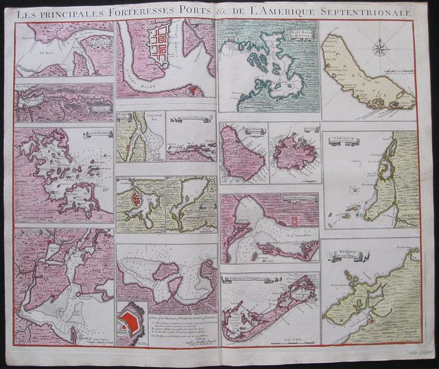
Forts and Islands for Henry Popple's Map of the "British Empire in America"
Popple, Henry; Covens, Jean & Mortier, Corneille.
Les Principales Fortresses Ports &c de L'Amerique Septrionale.
The Harbour of Placentia; The Harbour of Anapolis Royal; Boston Harbour; New York and Perthamboy Harbours;
The Town and Harbour of Charles town in South Carolina; Harbour of St. Augustin;The Harbour of Providence; The Havana; Bay of St Iagoin Cuba; A Plan of the Harbour of Port Antonio in Jamaica.
Fort Royal in Martinica; The Island of Barbadoes; Antigua; Kingston Harbour Jamaica; Bermuda or Summer Islands;
Curacao; Carthage on the Coast of New Spain; Harbour of Porto Bello. Amsterdam. Covens et Mortier c1741
Copper engraved map sheet with 17 (18) small plans and maps of forts, harbours and Islands for Popple's
Map of the British Empire in America from Covens & Mortier's
Nieuwe Atlas, Inhoudennde vier Gedeeltens der Waereld.. Original full wash colour; verso blank.
Covens and Mortier published the plans and maps which could be inserted on the Popple map as a separate map sheet .
Each plan or map has its title on a banner except the island of Curacoa and the plan of Port Antonio [with inset of the fort and key]
All are 150mm wide but of varying heights. St Augustine & Providence ; Havana & St Iago; Barbadoes & Antiqua in pairs.
Each has a mile scale and the map of Curacoa includes a compass rose.
A scarce and desirable sheet Dark impressions; bright full wash colour; printed on heavy paper;upper margin trimmed to plate mark above title; old red crayon numbers to verso.
Covens & Mortier
as a firm existed between 1721-1778, taking over the business of Pierrre Mortier.
Johannes / Jean Covens and Cornelius Mortier were brothers- in- law following the former's marriage to Mortier's sister Agatha in 1721, when they also formally went in to partnership.
Under the Covens and Mortier imprint, Cornelius and Jean republished the works of the great 17th and early 18th century Dutch and French cartographers De L'Isle, Allard, Jansson, & De Wit. The firm would become one of the most prolific Dutch publishing concerns of the 18th century.
The company would pass down through the Covens family as Mortier had no children, changing the name to Covens & Zoon until Pieter Mortier IV a great grandson of the original founder joined the firm and saw the name restored to Mortier Covens & Zoon. ( See Koeman I p45).
Henry Popple (16?? - 1743)
was a British cartographer active in the early part of the 18th century. Popple was a clerk with the Board of Trade and Plantations, the organization that governed Britain's colonies in America. With his father, grandfather, and brother all being employed the board of trade, the Popple family had a long history of association with the British colonial administration.
Popple received his commission as a clerk at the board of trade in 1727, but resigned in the same year to take a position as the Cashier to Queen Anne. In 1730, the Board began requesting detailed maps of the entirety of the provinces and contiguous French and Spanish Dominions. Popple had begun work on the map in 1727. He continued to work on his great maps and a manuscript version of the Popple Map appeared in this very year. Popple issued an announcement for the map in 1731, but did not complete work until 1733. as he continued to update and refine the map. The Board of trade intended the Popple map to be a British response to Delisle's French mapping of North America, which presented boundaries that conflicted with British colonial ambitions. However, since Popple in fact based much of his map on Delisle's superior cartography, he also managed to copy many of the French political boundaries - to the detriment of the Board of Trade and its expansionist intentions. Although Popple's map was never approved by the Board, examples were rushed to each colonial governor and the map played a significant role in the cartographic history of North America. Popple cartographic endeavor began and ended with this singular map however, it significance was such that he must be considered in any list of significant British mapmakers.
The large scale map was not a commercial success and did not sell well until after William Henry Toms and Samuel Harding took over publication in 1739. With the outbreak of the War of Jenkin's Ear, the map saw its commercial successes soar. In 1746, the rights to the map passed to Willdey and Austen, who published it until Austen's death in 1750.
Various other printers produced versions of the map in smaller format of which the Covens and Mortier version is undoubtedly the most fine.
Koeman I: C&M 8:maps 111; 520 by 620mm (20½ by 24½ inches).
ref: 3062
€2200