MAPS & VIEWS
PRINTS
BOOKS
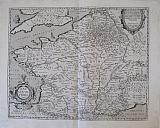
The Duchy of Burgundy, France.
 Burgundiæ Ducatus. "Burgundiae Inferioris, Quæ Ducatus Nomine Censetur Des. 1584." "Antverpiæ"/Antwerp. "ex Officiana Plantiana" . Plantijn Christoffel. 1595
Copper engraved map of Lower Burgundy, the Duchy from Ortelius' "Theatrum Orbis Terrarum" 1595 edition; black & white. Latin text to verso. Good dark impression; some dampstaining to lower blank margin.
Van de Krogt :3; .Koeman: Ort29: 32 [96]; van.de. Broecke:54 375 by 450mm (14¾ by 17¾ inches). €200
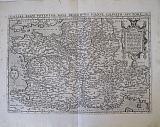
Calais, Boulogne & Vermandois, France.
 Caletetes & Bononieinsis; Veromandui. "Caletensium et bononiensium Ditionis Accurata Delineatio.."& "Veromanduorum Eorumque Confinitum Exactissima Descriptio.." "Antverpiæ"/Antwerp. "ex Officiana Plantiana" . Plantijn Christoffel. 1595
2 copper engraved maps on 1 plate of Calais & Boulogne (after Nicolao Nicolai delphinatus, Paris 1558) & Vermandois (after Johannes Surhon) from Ortelius' "Theatrum Orbis Terrarum" 1595 edition; black & white. Latin text to verso. Good dark impression: wormhole to lower centrefold between the maps; show through of title from verso.
Van de Krogt :3; .Koeman: Ort29: 26 [139]; van.de. Broecke:44a,b. 335 by 480mm (13¼ by 19 inches). €150
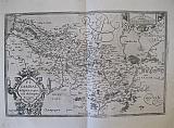
Ancient France.
 Gallia Strabonis, Ceterorumq. "Galliæ Veteris Typus.." "Antverpiæ"/Antwerp. "ex Officiana Plantiana" . Plantijn Christoffel. 1595
Copper engraved map of Ancient France from "The Parergon "of Ortelius' "Theatrum Orbis Terrarum" 1595 edition; black & white. Latin text to verso.
Ortelius paid particular reference to the description of Strabo. Good dark impression.
Van de Krogt :3; .Koeman: Ort29: F [27p]; van.de. Broecke: 196 395 by 490mm (15½ by 19¼ inches).` €150
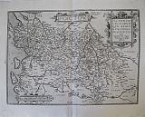
France.
 Gallia. "Galliae Regni Potentiss Nova Descriptio." "Antverpiæ"/Antwerp. "ex Officiana Plantiana" . Plantijn Christoffel. 1595
Copper engraved map of France [after Ioanne Ioliveto] from Ortelius' "Theatrum Orbis Terrarum" 1595 edition; black & white. Latin text to verso. Good dark impression.
Van de Krogt :3; .Koeman: Ort29: 21 [9]; van.de. Broecke:34. 350 by 505mm (13¾ by 20 inches). €400
The South of France, Savoy & Avignon.
 Galliae Narbonensis ora Maritima; Sabaudia; Venuxiensis Comitatus. "Gallia Narbonens.", "Sabudiae Ducat..."& "Venuxini Comitatus Nova Descr..." "Antverpiæ"/Antwerp. "ex Officiana Plantiana" . Plantijn Christoffel. 1595
3 copper engraved maps on 1 plate of :the southern coast of France from Narbonne to Marseille; the Savoy and Venaisssin, the area of Avignon, from Ortelius' "Theatrum Orbis Terrarum" 1595 edition; black & white. Latin text to verso. Good dark impression; some dampstaining to lower blank margin.
Van de Krogt :3; .Koeman: Ort29: 29 [108]; van.de. Broecke:49a,b,c. 355 by 465mm (14 by 18¼ inches). €200
Lorraine, France.
 Lothringia. "Lorraine. Lothringiae Nova Descriptio." "Antverpiæ"/Antwerp. "ex Officiana Plantiana" . Plantijn Christoffel. 1595
Copper engraved map of Lorraine from Ortelius' "Theatrum Orbis Terrarum" 1595 edition; black & white. Latin text to verso. Good dark impression; some dampstaining to lower blank margin.
Van de Krogt :3; .Koeman: Ort29: 30 [122]; van.de. Broecke:50. 340 by 505mm (13½ by 20 inches). €200
Picardy, France.
 Picardia. "Picardiae, Belgicæ regionis Descriptio..." "Antverpiæ"/Antwerp. "ex Officiana Plantiana" . Plantijn Christoffel. 1595
Copper engraved map of Picardy, formerly in Belgium (after Johannes Surhon) from Ortelius' "Theatrum Orbis Terrarum" 1595 edition; black & white. Latin text to verso. Good dark impression; some spotting to blank margins.
Van de Krogt :3; .Koeman: Ort29: 27 [77]; van.de. Broecke:46. 330 by 510mm (13 by 20 inches). €200
Poitiers, France.
 Pictavia. "Poictou / Poictonum Vicinarumque regionum Fidiss Descriptio.." "Antverpiæ"/Antwerp. "ex Officiana Plantiana" . Plantijn Christoffel. 1595
Copper engraved map of Poitiers/ Poitou, France from Ortelius' "Theatrum Orbis Terrarum" 1595 edition; black & white. Latin text to verso.
With 2 title cartouches, the map shows the region of Poitiers to the Atlantic coast with the islands of Oleron & de Re. Good dark impression.
Van de Krogt :3; .Koeman: Ort29: 23 [75]; van.de. Broecke:38. 360 by 505mm (14¼ by 20 inches). €200
Corsica.
 Girolamo Porro.
Corsica. "Descrittione dell'Isola di Corsica." Venice Simone Galignani & Girolamo Porro. 1620
Girolamo Porro.
Corsica. "Descrittione dell'Isola di Corsica." Venice Simone Galignani & Girolamo Porro. 1620Copper engraved map of Corsica by Girolamo Porro from Porcacchi's " L'Isole piu Famose del Mondo" 1620 6th edition [ 1st 1572]. Set in a page of descriptive Italian text, with decorative woodcut headpiece and historiated initial. Single page. folio, text to verso.
Dolphins surround the island. Good impression; lightly toned.
110 by 149mm (4¼ by 5¾ inches). €200
Corsica.
 Corsica divided into her ten Provinces or Jurisdictions and her four Fiefs "Carte Particuliere de L'Isle de Corse Divisee par ses Dix Provinces ou Juridictions et ses quatre Fiefs." Venice, Remondini, 1776
Copper engraved map of Corsica after Jaillot, from Santini's "Atlas universel dressé sur les meilleures cartes modernes". Original outline colour; verso blank.
The map shows the island in large scale filling the page,indeed almost escaping the scale lines, so that the "Capo Corso" is shown as an inset vignette. Large decorative title cartouche upper right, table of remarks to lower left below inset map. Dark impression; paper lightly toned.
Phillips 647; Cervoni, F., Image de la Corse, 112.1. 487 by 667mm (19¼ by 26¼ inches). €600
Perche & Blasois, France.
 The County of Blaisois. The County of Perche. "Comitatus Blesensis, Auctore Joanne Temporio. Blaisois." & " Perchensis Comitatus. La Perche Comte". Amsterdam Schenk, Petri & Valk Gerardi c1700
Copper engraved maps, 2 on 1 plate of of the region of Blaisois and Perche in France from Schenk And Valk's " Atlas Contractus." Original full wash colour; verso blank.
The map shows the region of Blaisois with the capital Blois on the Loire in the Loir-et-Cher department and Perche former province of western France extending over the départements of Orne, Eure, Eure-et-Loir and Sarthe,from which many emigrated to Canada in the 17th century leading to most French Canadians being able to trace their ancestry back to this region,
Each map with decorative title cartouche. Dark impression; clean and bright; green lines slightly oxidised/browned, small cracking near centre of centrefold. along the Loire on map of Blaisois; 1 wormhole to map of Blaisois, by town of St Laurent with another in the blank margin above; 2 old ink numbers to upper right corner, and one to verso.
Koeman III,page 113, map 280. 402 by 510mm (15¾ by 20 inches) full plate. €200
Beauce, France.
 The Region of Beauce "Belsia Vulgo La Beausse." Amsterdam Schenk, Petri & Valk Gerardi c1700
Copper engraved map of the region of Beauce in France from Schenk And Valk's " Atlas Contractus." Original full wash colour; verso blank.
The map shows the agricultural region of Beauce with the capital Chartres.
Decorative title cartouche, with Ceres harvesting grain and a cart drawn by dragons; coat of arms upper right with scale. Dark impression; clean and bright; old ink number to verso.
The maps of Schenk and Valk are famous for their full wash colour , however often the pigments, particularly in the greens deteriorated leading to browning and eventually could cause the paper to crack, for this reason it is unusual to see such bright original colour.
Koeman III,page 113, map 281. 384 by 496mm (15 by 19½ inches). €250
Blaisois, France.
 The Region of Blois, Blaisois. "Description du Blaisois." Amsterdam Schenk, Petri & Valk Gerardi c1700
Copper engraved map of the region of Blaisois in France from Schenk And Valk's " Atlas Contractus." Original full wash colour; verso blank.
The map shows the region of Blaisois with the capital Blois on the Loire in the Loir-et-Cher department.
Decorative title cartouche, scale and coat of arms. Dark impression; clean and bright; old ink number to verso.
The maps of Schenk and Valk are famous for their full wash colour , however often the pigments, particularly in the greens deteriorated leading to browning and eventually could cause the paper to crack, for this reason it is unusual to see such bright original colour.
Koeman III,page 113, map 282? 372 by 485mm (14¾ by 19 inches). €200
Company: Bryan, Mary Louise.
Address: Ag. Andrianoy 92 , 21 100 Nafplio, Greece.
Vat No: EL 119092581