
MAPS & VIEWS
PRINTS
BOOKS
back to search results place the mouse over an image to zoom
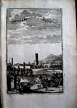

Fes, Marocco & North Africa.
"Marocco" "Marock"; "Salé"; "Tanger, Salé" Paris. Thierry. Denys. 16833 Copper engraved views of Fes/ Fez, Salé, & Salé with Tangiers from Mallet's "Description de l'Univers" 1st edition. , 3 plates, text to verso [Tangiers/ Salé]. Others blank to verso. Dark impressions.
Allain Manesson Mallet 1630- 1706, French cartographer, engineer and mathematician, served in the army of Louis XIV, and also that of the King of Portugal later becoming Inspector of Fortifications to Louis. He published the "Description de l'Univers" in 1683, attempting to describe the cartography, towns, ports, people, habits and traditions of the known world. The work extended to 5 volumes with some 600 illustrations.
His other works were"Les Travaux de Mars, ou L'art de la Guerre" 1684, and "La geometerie Practique" 1702.
155 by 100mm (6 by 4 inches) Fes. 151x105mm Tanger/Salé; 148x105mm Salé. ref: 1173 €75
Company: Bryan, Mary Louise.
Address: Ag. Andrianoy 92 , 21 100 Nafplio, Greece.
Vat No: EL 119092581