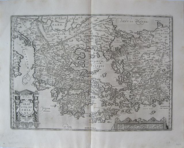
Ancient Greece according to Sophiani.
Ortelius, Abraham.
Græcia sive Hellas. "
Graecia Sophiani." "
Antverpiæ"/Antwerp.. "
ex Officiana Plantiana" . Plantijn Christoffel.. 1595
Copper engraved map of Ancient Greece according to the description of Sophiani from "
The Parergon " of Ortelius' "
Theatrum Orbis Terrarum" 1595 edition; black & white. Latin text to verso.
The map shows Ancient Greece and her colonies, according to the description of Nikolaos Sophianos.
Based upon Nikolaus Sophianos' map of Greece around 1540 which appears in Nicolai Gerbelji "
In Descriptio Graciae Sophiani Prefatio " published by Johannes Oporinus in Basel in 1545 as an eight block woodcut map, and in 1552 as a four sheet engraved map. Good dark impression; a few light spots to engraved area.
Abraham Ortelius,[ 1527-1598] Flemish Cartographer . produced the first modern Atlas "
Theatrum Orbis Terrarum" in 1570. printed by Aegidus Coppen Diest.
There were numerous editions thereafter with texts in various languages; the printing of such was taken over by Chrstoffel Plantijn in 1579 .
Ortelius himself drew all the maps in manuscript before passing them to the printers. there is conjecture that he may have engraved some of the plates as well
The 1595 Latin text edition is the most complete produced during his lifetime, containing all the maps of the 1593 edition plus those of the the"
Additamentum" and the"
Pareragon" or Ancient geography.
The "
Additamenta" were supplements to the original Atlas; at the same time Ortelius replaced some maps with new ones showing the same place; some plates were also reworked .
Ortelius was Geographer Royal To Phillip II of Spain from 1575. He also worked closely with Braun & Hogenburg on the "
Civitas Orbis Terarum".
After his death the plates were purchased by Jan Baptiste Vrients in 1601 who published further editions until 1612.
Van de Krogt :3; .Koeman: Ort29 Q [3P]; Zacherakis: 2495/1616; van den Broecke:215. 353 by 500mm (14 by 19¾ inches).
ref: 1750
€600