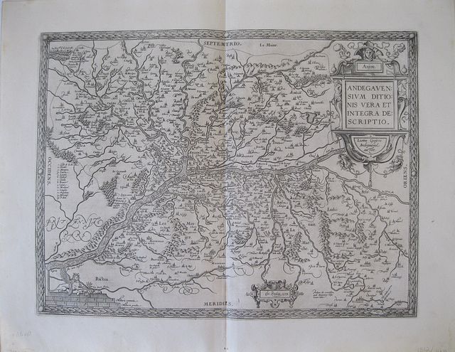
Anjou, France.
Ortelius, Abraham.
Andegavenium Ducatus. "
Anjou, Andegavensium Ditionis Vera et Integra Descriptio." "
Antverpiæ"/Antwerp. "
ex Officiana Plantiana" . Plantijn Christoffel. 1595
Copper engraved map of Anjou (after
Licinio Guyeto/ Lezin Guyet 1515-80) from Ortelius' "
Theatrum Orbis Terrarum" 1595 edition; black & white. Latin text to verso. Good dark impression: wormhole to lower centrefold within "MERIDIES"; tear [18mm]at lower centrefold caused by guard, repaired.
Abraham Ortelius,[ 1527-1598] Flemish Cartographer . produced the first modern Atlas "
Theatrum Orbis Terrarum" in 1570. printed by Aegidus Coppen Diest.
There were numerous editions thereafter with texts in various languages; the printing of such was taken over by Chrstoffel Plantijn in 1579 .
Ortelius himself drew all the maps in manuscript before passing them to the printers. there is conjecture that he may have engraved some of the plates as well
The 1595 Latin text edition is the most complete produced during his lifetime, containing all the maps of the 1593 edition plus those of the the"
Additamentum" and the"
Pareragon" or Ancient geography.
The "
Additamenta" were supplements to the original Atlas; at the same time Ortelius replaced some maps with new ones showing the same place; some plates were also reworked .
Ortelius was Geographer Royal To Phillip II of Spain from 1575. He also worked closely with Braun & Hogenburg on the "
Civitas Orbis Terarum".
After his death the plates were purchased by Jan Baptiste Vrients in 1601 who published further editions until 1612.
Van de Krogt :3; .Koeman: Ort29: 25 [76]; van.de. Broecke:40. 355 by 470mm (14 by 18½ inches).
ref: 1812
€200