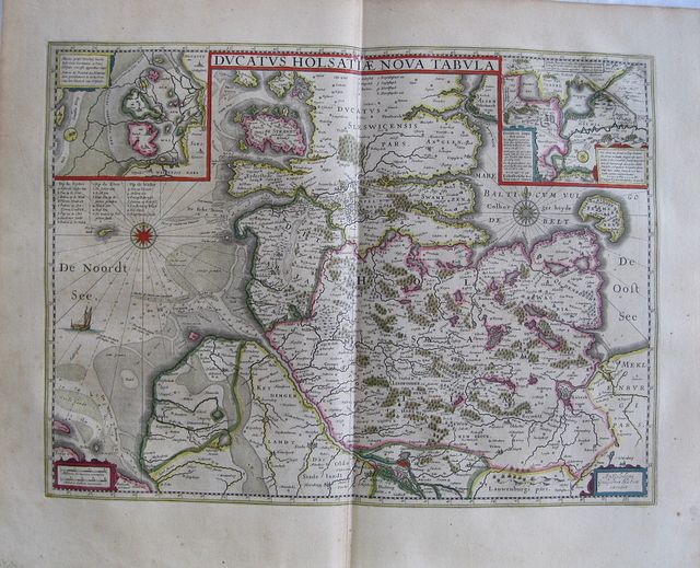
The Duchy of Holstein, Germany.
Blaeu, Guiljemus.
Le Duche d'Holsace. "
Ducatus Holsatiæ Nova tabula." Amsterdam Apud Guiljelmum et Joahannem Blaeu. 1647
Original coloured, copper engraved map of the Duchy of Holstein from volume 1 of Joan Blaeu's"
Le theatre du Monde ou Nouvel Atlas." Double page; folio; French text to verso.
Decorative Map showing the Duchy of Holstein and part of Schleswig in Denmark; inset maps to upper corners; to the left "A
lluvies prope Detzbul" showing the small islands of Detzbul, marked with letters on the main map; to the right, the inset map is entitled:"
Tabula Barmerensis, Meggerensis et Noort Staeplerensismaris.." giving an enlarged view of the lakes of Stapelholm.
Compass roses to both the North & Baltic seas, extensive sandbanks shown off the coast in the North sea. Original colour;blank margins slightly soiled with a scattering of spots; light toning to North Sea.
Willem Janszoon Blaeu [1571- 1668] had set up the business in Amsterdam 1596 following studies with the famous astonomer Tycho Brahe.
In 1630 Willhem published his first atlas "
Atlas Appendix", having published maritime cartography, books, charts and pilot guides for previous thirty years.
Appointed Hydrographer of the V. O. C. ( United East India Company)in 1633 he died in 1638. leaving the company to his sons Joan and Cornelius
Of Cornelius little is know; his name appearing on in the prefaces of books and atlases only until c1645.
Dr Joan Blaeu [ 1596-1673] who had studied at Leiden took over the management of the business and established its fame. He was also appointed Hydrographer to the V. O. C. ( 1638), but his interests leant more to geography than maritime cartography. His aim was" a full description of heaven, earth and water" ( Koeman) which was unachievable. but his work produced the magnificent "
Atlas Major" and the Town books of the Netherlands and Italy; works unsurpassed in history and modern times.
The "
Theatrum Orbis Terrarum " or "
Atlas Novus" Willem Blaeu's great project enlarging the
"Appendix" was advertised in 1634, was first published in a preliminary edition in 1635. (preface dated 10-3-1634) two volumes.
The final edition comprising again two volumes with 109 & 99 maps respectively with German text also published 1635; an edition with Dutch text, (preface dated 22-4-1635) 104 & 103 maps; French text( preface dated 1-7-1635) 105 & 103 maps; and with Latin text (preface dated "ipsis Aprillis")105 & 102 maps.
In 1640, after Willem's death a Third volume with French text and comprising 58 maps of Italy and 8 of Greece, was published; later the same year an edition was produced with Latin text.
Still in 1640, variant editions in both languages were issued with an appendix of 4 maps of the British Isles as a precursor to the Fourth volume, which would be a complete description thereof.
In 1645 the Fourth volume,
"Le Theatre du Monde ou Nouvel Atlas, Mis en lumiere par Guillaume et Jean Bleau. Quartiesme Partie." with a dedication to "
A la serinissme Princesse Henriette-Marie Reine de la Grande Bretagne, France & Yrlande." was published; preface dated 1 October 1645.
This volume consisted of 58 maps with description of all the British Isles.
The "
Atlas Novus" was eventually extended to six volumes with the addition of a fifth volume, Scotland in 1654 and the following year a sixth the "
Atlas Sinensis"of Martini.
Joan Blaeu recognised that the wealthy patrons who would buy such an atlas were primarily concerned with display, thus aesthetic considerations were emphasised: the quality of the paper, binding, beautiful typography and bright colour, making maps from the Blaeu printing house amongst the most decorative of their time.
Blaeu eventually updated and extended the "
Theatrum" producing the "
Atlas Major" in various formats from 9-12 volumes
Koeman1, Bl 16A [13(O)] 382 by 513mm (15 by 20¼ inches).
ref: 2182
€350