MAPS & VIEWS
PRINTS
BOOKS
back to search results place the mouse over an image to zoom

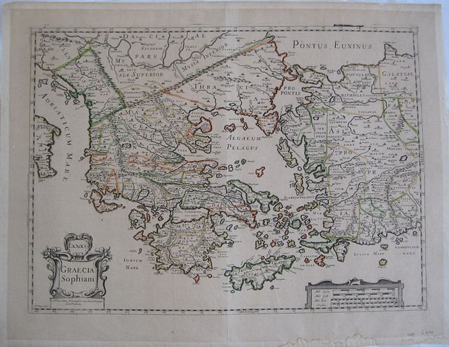
Scarce French map after Ortelius's "Graecia Sophiani".
"H LeRoy Fecit" Greece. "Ελλαs. Graecia Sophiani." "A Paris " "Chez N Langlois rue Saint Jaques àla Victoire" c1640-60Copper engraved map of Greece after Ortelius by Henri Le Roy. Original outline colour; verso blank.
Decorative title cartouche and scale.
The map by Henri Le Roy seems to have first been published by Michel Van Lochom in 1636 and then by J Boisseau in 1643 in his " Tresor des Cartes Géographiques". Thereafter the plate seems to have passed through a number of hands including that of Pierre Mariette who was stepfather to Nicolas Langlois the present publisher. Dark impression; signs of former framing, leading to toning and tape to edges on verso; dampstain to lower margin; centrefold split, due to removal of guard, repaired to verso.
Henri Le Roy (1579-1652) was a Parisian engraver.
Little is known about Le Roy, however the British Museum have a set of plates by him depicting insects "Le Jardin de Sauterelles et Papillons," France, c1650 which they believe were intended to serve as a pattern for craftsmen working in the decorative arts such as embroidery or metalwork. The Victoria and Albert Museum also have a further series of engravings" this series of seven frieze designs, which could have been put to use as designs for architectural ornaments, textiles or other objects" Both of these fit with the publisher Michel van Lochom "Graveur et Imprimaeur du Roy" who published a number of works on design and ornamentation and may well have asked Le Roy an engraver known to him to copy Ortelius map as interest increased in cartography in France.
"The practice of plagiarizing prints or maps seems to have been common in the seventeenth century,and it does not seem to have been dishonorable: consider, for example, the copies of Dutch maps from the Nether-
lands (of Artois and Boulonnaise, Hainaut and Cambrésis, Luxembourg, and Savoy) signed by Pierre Duval, the nephew of Nicolas I Sanson d'Abbeville, in 1646 and published by Pierre I Mariette." [Pastoureau",Les Atlas Français" ,pp497–500."]
Langlois, François (1588-1647) French. was a painter, publisher-printseller,and bookseller who lived on rue Saint-Jacques "AuxColonnes d'Hercules." his widow married Pierre Mariette II in 1655. In 1637, only 5 percent of his stoc kconsisted of topographical plates or blocks. The rest was composed of ornamental engravings In 1644, he bought part of Tavernier's stock.
In 1655, eight years after Langlois's death, his son Nicolas I Langlois distributed the maps of French geographers, such as Tassin, Sanson,and Duval, as well as those of foreign cartographers, suchas Nicolaas Visscher and Vincenzo Coronelli.
His own son was another Nicolas (c.1670-1707) who took over his father's shop in 1703. [see "The History of Cartography." vol 3, part 2,chapter 53 "Publishing and the Map Trade in France, 1470 –1670' by Catherine Hofmann]
This edition not in Zacharakis [ Zacharakis; 2019/1344, 2020/1345, 2021/1346 and 451/274 variants] 355 by 488mm (14 by 19¼ inches). ref: 2489 €850
Company: Bryan, Mary Louise.
Address: Ag. Andrianoy 92 , 21 100 Nafplio, Greece.
Vat No: EL 119092581