MAPS & VIEWS
PRINTS
BOOKS
back to search results place the mouse over an image to zoom
The Northern Aegean in Ancient times.
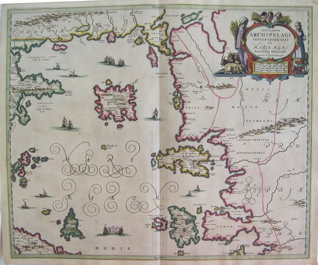
J Janssonius/ Johann Lauremberg "N. Visscher excudit." Northern Aegean Archipelago. "Insularum Archipelagi Septrionalis seu Maris Ægæ, Accurata Delinatio Auctore J Laurenbergio." Amsterdam J. Janssonius 1650Copper engraved map of the Northern Archipelago after Laurenberg by Janssonius. Original colour; verso blank.
The map shows the Northern Aegean with the islands of the Northern Archipelago: Limnos, Mytelline, Chios Samos, Imbro etc; Mount Athos and Skyros with the Sporades to the left and the coast of Asia Minor to the right.
Decorative title cartouche [ original colour]. Sailing ships to sea. Laurenberg's map is of the area in ancient times, giving the ancient names.
The map first appeared in Janssonius' "Atlantis Majoris Quinta Pars, Orbem Maritimum" and later in 1552 in the 6th Volume entitled "Accuratissma Orbis Antiqui Delineatio Sive Geographia vetus, sacra,& profana." Good dark impression, generally bright; light offsetting and ocassional spots; short split at lower centre fold and two minor tears[ backed with archival tape].
Johann Wilhelm Lauremberg (1590-1658).was a philologist, mathmatician and satiric poet.
He studied from 1605 in Rostock. Between 1612 and 1617 he undertook educational trips to Holland, England, France and Italy. Among other things, he studied medicine from 1613 to 1616 in Paris. From 1618 to 1623 he was Professor of Poetry at the University of Rostock and thereafter until his death Professor of mathematics at the Knight Academy in Soro. His maps appeared in the atlases of Blaeu, Jansson, Hondius and others
His atlas "Græcia Antiqua" was published after his death in 1660 by Janssonius, edited by Samuel Puffendorf.
Johannes Janssonius (approx. 1588-1664)
came from a family of printers and publishers and learned the book printing trade at an early age. In 1612 he married the daughter of Jodocus Hondius and thus became a member of one of the most important publishing families in the Netherlands. During the 1630s he went into partnership with his brother-in-law Henricus Hondius and published more editions of the Mercator/Hondius atlases with the addition of the name Jansson. He grew their publishing house in the fields of geography and cartography and published newly compiled world, sea and city atlases, always competing with the Blaeu publishing house. His main works were the "Atlas Majoris Appendix" (1639), the six-volume "Atlas Novus" (1638 ff.) and the monumental "Atlas Major" comprising eleven volumes (1647).
Zacharakis 1905/1276 .Koeman II; Me.164 map 676. 485 by 582mm (19 by 23 inches). ref: 2496 €800
Company: Bryan, Mary Louise.
Address: Ag. Andrianoy 92 , 21 100 Nafplio, Greece.
Vat No: EL 119092581

