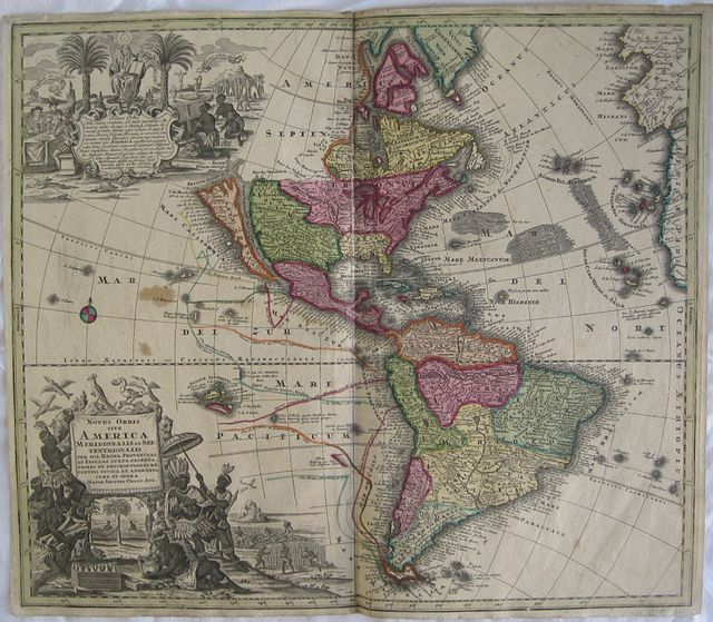
The Americas with California as an Island.
Seutter, Matthäus
The New World: America North and South with the Kingdoms, Provinces and Islands. "Novus orbis sive America Medionalis et Septentrionalis per sua Regna, Provincias et insulas Juxta Observatioes et Descriptiones Recentis. Divisa et Adornata cura et Opera Matth. seutter Chalc. Aug.". Augsburg, Seutter, Matthäus c 1730
Copper engraved map of the American continent from Seutter's
"Atlas Novus". Original old full wash colour; verso blank.
The map,engraved for Seutter by Gottfried Rogg, shows the whole of the Americas, North and South with California as an island. The map has full orignal wash colour designating the kingdoms and provinces; colored lines showing the routes of explorers in the Pacific with the dates of their voyages and a host of other information.
Very large decorative vignettes around title and text to upper and lower left corners. The upper shows 3 Europeans seated with the Madonna above text and native Americans at an alter, thus depicting the arrival of Christianity to the Continent. The lower vignette around the title has a native American monarch possibly Atahualpa surrounded by other natives and exotic fauna, in the background figures, possibly slaves, harvest sugar cane and tobacco. Good dark impression;some soiling mainly to margins; 2 stains in Pacific possibly from wax; slight browning to centrefold; margins short due to size of plate [approx. 10mm to image]; old ink title to verso.
Seutter, Matthäus (The Elder): 1678–1757,
Seutter was an engraver, globe-maker and publisher.
Born in Augsburg in 1685, the son of a goldsmith. Seutter began his studies in Nuremberg in 1697, apprenticed as an engraver to Johann Baptist Homann. in 1707 later he returned to Augsburg subsequently working in the publishing house of Jeremias Wolff in the city. He founded the Seutter publishing house and print shop in 1710, producing maps, atlases, and globes., which became a primary competitor to Homann.
Very few original maps were printed there, as Augsburg at that time had no university and none of the necessary connections to the fields of mathematics or the natural sciences. Therefore Seutter copied the work of other cartographers, making his own engravings based on their models (approximately 500 pieces).
His "
Atlas Geographicus oder Accurate Vorstellung der ganzen Welt' appeared in 1725 with 46 maps: the "
Atlas Novus" various editions in 1728, 1730, 1736, 1742; the "
Grosser Atlas"in 1734 with 131 maps, and the pocket atlas "
Atlas minor in 1744 with 64 maps.
After Matthäus Seutter died in 1757, his son, Albrecht Karl, his son-in-law Conrad Tobias Lotter, and his business partner Johann Michael Probst ran the business for five more years.
McLaughlin 211; Tooley, 91 p.132. 502 by 582mm (19¾ by 23 inches).
ref: 2527
€2000