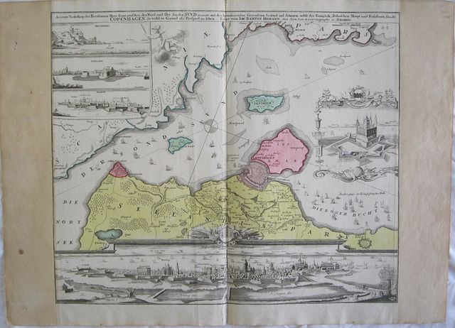
Sund Sound with a Prospect of the City of Copenhagen.
Homann, Johann Baptist.
Accurate presentation of the famous sea-strait between the North and East of the lake called Sund; with surrounding area of Zealand and Scania, along with the Royal palace and city of COPENHAGEN.. "
Accurate Vorstellung der Beruhmten Meer-Enge Zwischen der Nord und Ost See der Sund Genant, mit der herumligenden Gegend von Seeland und Schonen nebst der Koniglich-Danischen Haupt und Residentz Stadt Copenhagen.." Nuremberg Homann, Johann Baptist. 1720
Copper engraved map of Copenhagen and the sound of Sund from Johann Bapt. Homann's "Grosser Atlas.". Original colour to map; vignettes black & white as issued; verso blank.
The map in the upper two thirds of the plate shows the position of Copenhagen on the Sund sound with the coast of Sweden opposite. Inset vignette to upper left with views of Malmo, Landschorn and Helsingburg; to the right vignette of the castle of Cronenburg, within decorative scrollwork frame; below the map a full prospect of the city of Copenhagen. Fair impression; bright colours; trimmed to plate mark at sides, at some time remargined with old laid paper which is slightly toned; short tear (approx 20mm). close to lower centrefold [repaired with archival tape to verso],and slight centrefold split.
Johann Baptist Homann (1664 – 1724)
from 1687 Homann worked as a civil law notary in Nuremberg. He soon turned to engraving and cartography; in 1702 he founded his own publishing house.
Homann acquired renown as a leading German cartographer, and in 1715 was appointed Imperial Geographer by Emperor Charles VI. Giving such privileges to individuals was an added right that the Holy Roman Emperor enjoyed. In the same year he was also named a member of the Prussian Academy of Sciences in Berlin. Of particular significance to cartography were the imperial printing privileges (Latin: privilegia impressoria). These protected for a time the authors in all scientific fields such as printers, copper engravers, map makers and publishers. They were also very important as recommendation for potential customers.
In 1716 Homann published his masterpiece
"Grosser Atlas ueber die ganze Welt" Numerous maps were drawn up in cooperation with the engraver Christoph Weigel the Elder,
Homann died in Nuremberg. He was succeeded by the Homann heirs company, in business until 1848, known as "Homann Erben", "Homanniani Heredes", "Heritiers de Homann" abroad.
495 by 577mm (19½ by 22¾ inches).
ref: 2536
€800