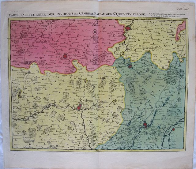
Nord-Pas de Calais, France.
Covens, Jean & Mortier, Corneille.
Fricx< Eugène Henry
The Environs of Cambray, Bappaumes, St Quentin, Peronne after the copy in Brussels by E.H.Freix "
Carte particuliere des environs de Cambray, Bappaumes, St. Quentin, Perone ......;sur la copie de Brussel par E: H: Friex ;." Amsterdam Covens et Mortier 1745
Copper engraved map of the environs of Cambray, Bapaumes, St. Quentin and Peronne in Northern France from Covens & Mortier's "
Atlas des Pays Bas,.. " Original full wash colour; verso blank.
The map appears first in Eugéne Fricx' "
Tables des cartes des Pays Bas et des frontiers de France ..." published in 1712, an atlas of battles and sieges, here republished by Covens & Mortier.
The map shows the often fought over area in Northern France. at the time of the War of Succession. Dark impression; clean and bright colour; old ink number to upper right corner.
Covens & Mortier
as a firm existed between 1721-1778, taking over the business of Pierrre Mortier.
Johannes / Jean Covens and Cornelius Mortier were brothers- in- law following the former's marriage to Mortier's sister Agatha in 1721, when they also formally went in to partnership.
Under the Covens and Mortier imprint, Cornelius and Jean republished the works of the great 17th and early 18th century Dutch and French cartographers De L'Isle, Allard, Jansson, & De Wit. The firm would become one of the most prolific Dutch publishing concerns of the 18th century.
The company would pass down through the Covens family as Mortier had no children, changing the name to Covens & Zoon until Pieter Mortier IV a great grandson of the original founder joined the firm and saw the name restored to Mortier Covens & Zoon. ( See Koeman I p45).
Eugéne Henri Fricx,
was a bookseller and publisher established in Brussels, He published his"
Tables des cartes des Pays Bas et des frontiers de France ..."in 1712 giving maps and plans of the War of Succession.In the same year he published his 23 maps of his 24 sheet map of the Southern Netherlands [ the map of Luxembourg was eventually published in 1727.] He died in around 1740 and though he had children the business did not continue, allowing Covens and Mortier to republish his atlas and the map which the firm sold up until the 1780s
Koeman I, C&M 17, map 21: Fri1 map 21. 440 by 568mm (17¼ by 22¼ inches).
ref: 2546
€350