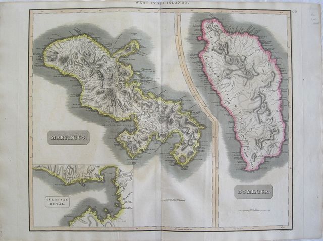
Islands of the West Indies: Martinique and Dominica.
John Thomson
Martinique; the bay at Fort Royal and Dominica. "
Martinico; Dominica; Cul de Sac Royal." Edinburgh, London & Dublin John Thomson;
Baldwin, Cradock, and Joy; John Cumming. 1817
Copper engraved map showing Martinique and Dominica from Thomson's "
A New General Atlas." Original outline colour; verso blank.
The large map shows the two islands engraved on one plate. The map of Martinique includes an inset map of the bay at Fort Royal.
The map served as the source for Fielding Lucas.
In 1635, Pierre Belain d'Esnambuc, French governor of the island of St. Kitts, landed in the harbour of St. Pierre with 150 French settlers after being driven off St. Kitts by the English. D'Esnambuc claimed Martinique for the French King Louis XIII and the French "Compagnie des Îles de l'Amérique" (Company of the American Islands), and established the first European settlement at Fort Saint-Pierre (now St. Pierre).
In 1636, the indigenous Caribs rose against the settlers to drive them off the island in the first of many skirmishes. The French successfully repelled the natives and forced them to retreat to the eastern part of the island, on the Caravelle Peninsula in the region then known as the Capesterre. When the Carib revolted against French rule in 1658, the Governor Charles Houel de Petit-Pré retaliated with war against them. Many were killed; those who survived were taken captive and expelled from the island. Some Carib had fled to Dominica or St. Vincent, where the French agreed to leave them at peace. Good impression, generally clean & bright; slight very light offsetting; tiny paper faults to left blank margin,and slight thinning in the image of Martinique; tiny pinprick to centrefold; upper general title in margin just shaved;old ink number to upper right corner.
John Thomson (1777-c1840),
was a Scottish cartographer from Edinburgh, celebrated for his 1817
New General Atlas, published by himself in Edinburgh, John Cumming in Dublin, and Baldwin, Cradock, and Joy in London.
The title page described it as:
"A new general atlas, consisting of a series of geographical designs, on various projections, exhibiting the form and component parts of the globe; and a collection of maps and charts, delineating the natural and political divisions of the empires, kingdoms, and states in the World. Constructed from the best systematic works, and the most authentic voyages and travels. With a memoir of the progress of geography, a summary of physical geography, and a consulting index to facilitate the finding out of places. Edinburgh: Printed by George Ramsay and Company, for John Thomson and Company, Edinburgh; Baldwin, Cradock, and Joy, London; and John Cumming, Dublin. 1817."
The atlas was probably inspired in part by Pinkerton's
Modern Atlas of 1815, which it resembles. Pinkerton began publishing his atlas maps in parts as early as 1809, while Thomson started in 1814. Thomson used engravers of Edinburgh, including Kirkwood, Menzies, and Moffat, as well as the London engravers Hewitt and Neele (Neele also engraved all the maps for Pinkerton's
Modern Atlas).
Thomson adds about twenty maps not found in Pinkerton, eight of which are of islands in the West Indies that served as the source for Fielding Lucas' maps of those islands.
[David Rumsey Map Collection Catalogue/Cartography Associates.]
540 by 645mm (21¼ by 25½ inches).to plate mark.
ref: 2561
€250