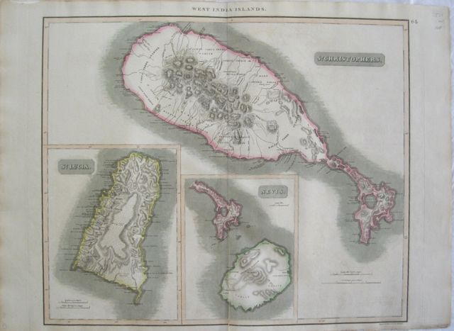
Islands of the West Indies: St. Kitts & Nevis with St. Lucia.
John Thomson.
St. Kitts & Nevis with St. Lucia "
St.Christophers; Nevis; St. Lucia." Edinburgh, London & Dublin John Thomson;
Baldwin, Cradock, and Joy; John Cumming. 1817
Copper engraved map showing St Kitts & Nevis with St. Lucia from Thomson's "
A New General Atlas." Original outline colour; verso blank.
The large plate has three maps on one plate: St. Kitts is depicted with inset smaller maps of Nevis and St. Lucia.
The map served as the source for Fielding Lucas. Good impression; short split at lower centrefold repaired with archival tape to verso; general title in upper margin; old ink number to upper right corner.
John Thomson (1777-c1840),
was a Scottish cartographer from Edinburgh, celebrated for his 1817
New General Atlas, published by himself in Edinburgh, John Cumming in Dublin, and Baldwin, Cradock, and Joy in London.
The title page described it as:
"A new general atlas, consisting of a series of geographical designs, on various projections, exhibiting the form and component parts of the globe; and a collection of maps and charts, delineating the natural and political divisions of the empires, kingdoms, and states in the World. Constructed from the best systematic works, and the most authentic voyages and travels. With a memoir of the progress of geography, a summary of physical geography, and a consulting index to facilitate the finding out of places. Edinburgh: Printed by George Ramsay and Company, for John Thomson and Company, Edinburgh; Baldwin, Cradock, and Joy, London; and John Cumming, Dublin. 1817."
The atlas was probably inspired in part by Pinkerton's
Modern Atlas of 1815, which it resembles. Pinkerton began publishing his atlas maps in parts as early as 1809, while Thomson started in 1814. Thomson used engravers of Edinburgh, including Kirkwood, Menzies, and Moffat, as well as the London engravers Hewitt and Neele (Neele also engraved all the maps for Pinkerton's
Modern Atlas).
Thomson adds about twenty maps not found in Pinkerton, eight of which are of islands in the West Indies that served as the source for Fielding Lucas' maps of those islands.
[David Rumsey Map Collection Catalogue/Cartography Associates.]
535 by 645mm (21 by 25½ inches).
ref: 2566
€200