MAPS & VIEWS
PRINTS
BOOKS
back to search results place the mouse over an image to zoom

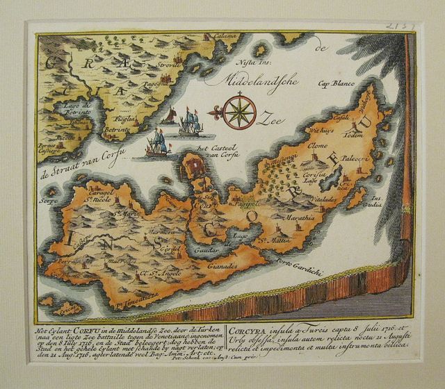
Scarce Small Map of Corfu.
The Island of Corfu.... Kerkyra. "Het Eilant Corfu.... Corcyra...." Amsterdam Schenk, Petri 1716=1720Copper engraved map of Corfu/Kerkyra by Petrus Schenk. Modern hand colour; verso blank.
Scarce small map of the island of Corfu, taken from a larger map sheet , probably from "Schouwburg van den oorlog, beginnende van Koning Karel den II, tot op Koning Karel den III Theatrum bellicum, incipiens a Carolo II. Hispaniarum Rege ad Carolum III. Amsterdam: Pieter Schenk."[1714-1720]
The map is drawn upon a drape or wall hanging with fringe; it shows the island lying off the coast , with the large bay of Butrinto . the text below in Dutch and French discusses the events of July 8th 1716. known as
The Siege of Corfu;after their success in the Morea, the Ottomans moved against the Venetian-held Ionian Islands. They had occupied the island of Lefkada (Santa Maura), which the Venetians had taken in 1684, and the fort of Butrinto opposite Corfu. On 8 July 1716, an Ottoman army of 33,000 men landed on Corfu, the most important of the Ionian islands. Despite an indecisive naval battle on the same day, the Ottoman land army continued its disembarkment and advanced towards the city of Corfu. On 19 July, after capturing the outlying forts of Mantouki, Garitsa, Avrami and of the Saviour, the siege began.[The defence was led by Count Johann Matthias von der Schulenburg, who had roughly 8,000 men at his command. The extensive fortifications and the determination of the defenders withstood several assaults. After a great storm on 9 August—which the defenders attributed to the intervention of Corfu's patron saint, Saint Spyridon—caused significant casualties among the besiegers, the siege was broken off on 11 August and the last Ottoman forces withdrew on 20 August. Good impression. good margins to left and bottom but short top and right as it has obvoiusly been cut from a larger sheet.
SCHENCK, Pieter 1660-1718/9
Dutch mapmaker and publisher. Born in Elberfeld, Germany in 1660. Moved to Amsterdam in 1683 where he became a pupil of Gerard Valck, later in 1687 he married Agatha Valck, sister of his associate., thus uniting two great families.
In 1686 he is noted in a privilege granted to Petrus Schenck and Gerardus Valck for the printing & sale of their prints.
The Valck and Schenk families where active as print sellers, publishers and printers of maps, atlases and architectural drawings as well globes. They accquired plates from the stock of Johannes Janssonius and also of Visscher reissuing several maps of Janssonius' "Atlas Novus "from 1683-94 and published an Atlas titled" Nova totius Geographia" in 1702.
The best known of the joint Pieter Schenk & Gerard Valck publications were the second edition of Andreas Cellarius's " Celestial Atlas Harmonia Macrocosmica'" 1708 and an edition of Jan Jansson's "Novus Atlas" entitled the "Atlas Anglois" published in London by David Mortier in 1715.
Pieter Schenck the Elder's earliest cartographic productions were a number of maps after Nicolas Sanson published in a composite Atlas, "Atlas Contractus or Atlas Minor" c.1696. He also published a further composite Atlas, "Atlantis sylloge compendiosa," c.1702.
Other works included his famous Atlas of one hundred town views," Hecatompolis" [1702];" Le Theatre de Mars "[1706]; and the "Schouwburg van der Oorlog"[1706].
Zacharakis; 3275/2139;Koeman III, page 116 Sche 7 160 by 180mm (6¼ by 7 inches). Pagesize;200x280mm. ref: 2896 €500
Company: Bryan, Mary Louise.
Address: Ag. Andrianoy 92 , 21 100 Nafplio, Greece.
Vat No: EL 119092581