
MAPS & VIEWS
PRINTS
BOOKS
back to search results place the mouse over an image to zoom
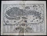
The Famous Bird's eye View Of Venice.
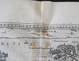
Venise Venetia. Cologne G. von Kempen 1575Black and white, copper engraved town plan of Venice from the first volume of Braun & Hogenberg's Civitas Orbis Terrarum. French text to verso.
The detailed engraving shows the city its buildings and extensive network of bridges and canals. The view shows important landmarks. Among them are the Piazza San Marco, with its famous basilica, Campanile (bell tower) and tall columns supporting statues of the Lion of Venice and St. Theodore. The many small islands surrounding the city are also depicted and labeled, such as the Island of San Giorgio with its Palladian church and monastery as well as Murano, where glass-making workshops were located. Ships, boats and gondolas traverse the waterways.
Below the view, a vignette illustrates a procession of the Doge of Venice (chief magistrate and government official) accompanied by other officials, each labeled with their title or role. On either side of the vignette, a numbered key corresponding to numbers on the view lists 35 principal canals and over 125 palaces, churches, convents, monasteries, bridges, hospitals and another important structures. These include the Arsenal, the bridge over the Rialto Canal and the location of the Jewish ghetto. Unrestored original condition, light toning and soiling; light spots near titleat centre fold and in Lagoon nearr S.Lazaro.
The "Civitas Orbis Terrarum" of Georg Braun and Frans Hogenberg was the first systemstic city atlas, possible intended to compliment the "Theatrum Orbis Terrarum "of Abraham Ortelius published in 1570.
There is strong evidence that Braun, Hogenberg and Ortelius discussed the planned work, although some scholars believe it was influenced by Sabastien Munster's "Cosmographia"
R A Skelton in his introduction to the facsimile edition [ 1965] puts the case f for the "Theatrum " of Ortelius being the model for the work ( "(it) is made abundantly clear by the similarity between the two works in title, in format and in the layout and serial order of the plates and text"
First publishe in 1572 in Cologne just two years after Ortelius' " Theatrum" it was published in six volumes in the years between 1572 and 1617.
Georg Braun [1541-1622], Canon of Cologne Cathedral wrote the preface for all but the last volume and also the text accompanying each plan or view on the verso.
The plates were engraved by Frans Hogenberg and Simon Novellanus after the original drawings of Joris Hoefnagel[1542-1600] who travelled with Ortelius through Italy and also made extensive travels through France Spain and England
Following the death of Frans Hogenberg the plates were engraved by Abraham Hogenberg, believed to be his son.
Jacob Hoefnagel continued the work of his father following his death, particularly the Austrian and Hungarian cities. Other notable contributers were Heinrich Rantzau with maps and plans of northern Europe, especially Denmark and Jacob van Deventer's plans of cities in the Netherlands. .
Braun corresponded with mapsellers and scholars throughout the world and it was his idea to include the figures of local inhabitants in the foreground of the plans and views, This was not just to add "Local colour" but believing the work could be of refence for Military use, particularly by the Turks. the insertion of images of the human form. specifically forbidden by Islam, was intended to prevent this.
Keoman 2; B&H 13, plate 44]. 335 by 484mm (13¼ by 19 inches). ref: 3206 €2500
Company: Bryan, Mary Louise.
Address: Ag. Andrianoy 92 , 21 100 Nafplio, Greece.
Vat No: EL 119092581