California as an Island.
Sanson d'Abbeville, Nicholas
A.d'Winter
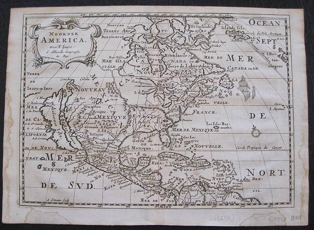
North America. Noorder America. Amsterdam Francois Halma 1705
Copper engraved map of North America by N. Sanson from Halma's
Algemeene Werelde BeschryvingVol. 3 Black and white; title in Dutch; verso blank; strapwork title cartouche.
Attractive small map showing North America with California as an Island
California is shown with an indented northern coastline in the Foxe form. The detached coastline to the northwest of California is named
Terre de Iesso ou Ieco,rather than reflecting Sanson's earlier belief that it was an extension of the American continent. The
R. de Nortdrains into the Gulf of California from a large interior lake in the country of
Les Apaches. The two western-most Great Lakes are left open-ended and
Lake Erieremains unnamed. Engraved by Antoine d'Winter. This is the third state which includes a peninsula inserted northeast of California, the Carolinas attributed to the French,
N. Iork added below
N. Amstredam, and an umlaut over the "
Roy" in the title.
This map appeared in
Algemeene Weereld-Beschryving, nae de Rechte Verdeeling der Landschappen, Plaetsen, Zeeën, Rivieren, &c. Geographisch, Politisch, Historisch, Chronologisch en Genealogisch, a Dutch edition of A. Phérotée de la Croix's
Nouvelle Methode Pour Apprendre Facilement la Geographie Universelle, which first appeared in 1690. Dark impression; dampstaining to edges not entering image.
Nicolas Sanson d'Abbeville.(1600-67),
' father of the French cartography' and founder of the Sanson firm. Atlas ' Cartes générales de toutes les parties du Monde', 1658-70 and a pocket atlas in 4 parts ( 1652-1705).
Sanson's small maps from A. Phérotée de la Croix's
Nouvelle Methode Pour Apprendre Facilement la Geographie Universelle,., first published in 1652 and engraved by A. Peyrounin, were copied several times by various map publishers. Johann David Zunners made copies of Sanson's maps for his German translation of
Die Gantze Erd-Kugel in 1679. Johannes Ribbius and Simon de Vries published copies in 1682 and 1683, with new maps engraved by Antoine d'Winter. The plates were later sold to Francois Halma, who used them in 1699 and then again in 1705 with the titles re-engraved in Dutch.
François Halma ( 1653 - 1722)
Dutch publisher/printer; dealer/auction house. Cartographer and publisher of maps, active in Utrecht, Amsterdam, Franeker and Leeuwarden.
Published 'Description de l'Univers' (1700); 'Algemene Wereldtbescrijving' (1705); 'Corpus Inscriptionum' (1707) and 'Lexicon Philosophicum' (1713).alma acquired many of the plates for Algemeene Weereld-Beschryving from Joannes Ribbius, who had enlisted the services of engraver Antoine de Winter to make copies of the maps in Nicolas Sanson's quarto atlases of the four continents. De Winter made very few geographical changes and maintained the attribution to Sanson on the newly engraved plates. Halma supplemented the Sanson maps with about a dozen new maps engraved in the same style as Sanson's, without any attribution on the maps, as well as 23 panoramic views of famous cities around the world.
Keoman: Hal 1; Phillips 528; Burden #545; McLaughlin #89-3. 204 by 284mm (8 by 11¼ inches).
ref: 3238
€700