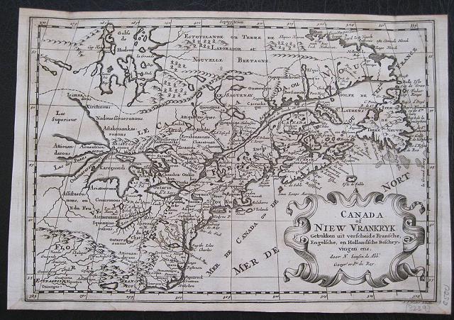
Sanson's influential map of Canada and the Great Lakes.
Sanson d'Abbeville, Nicholas
A.d'Winter
Canada of New France. Canada of Niew Vrankryk. Getrokken uit verschiede Franche, Engelsche, en en Hollandsche Beschrivingern enz. ... Amsterdam Francois Halma 1705
Copper engraved map of Canada by N. Sanson from Halma's
Algemeene Werelde BeschryvingVol. 3 Black and white; title in Dutch; verso blank; strapwork title cartouche.
Attractive small map of Canada and the Great Lakes, a reduced version of one of the most influential seventeenth century maps of the French and English colonies in North America. It concentrates on the region of greatest French interest. The entire Great Lakes basin and the St. Lawrence River are shown in great detail. The most important aspect of the map is the first appearance of
L. Erie, ou du Chat as a recognizable lake on an atlas map. This delineation influenced the cartography of the region for more than 100 years and was not superceded until Delisle's "
Carte du Canada" in 1703. The map is also an outstanding source for Indian tribal names and locations. Two names:
Aouentsiouaeronand
Attiouandaronsappear here for the first time. Lake Superior and Michigan
Lac du Puansare left open-end to the west. Embellished with a nice title cartouche and engraved by Anthoine d'Winter.
This is the third state. Published in Francois Halma's Dutch edition of A. Pherotee de la Croix's
Nouvelle Methode Pour Apprendre facilement la Geographie Universelle.
Dark impression; dampstaining to lower margin just entering plate; centrefold and 2 further folds, to fit in binding.
Nicolas Sanson d'Abbeville.(1600-67),
' father of the French cartography' and founder of the Sanson firm. Atlas ' Cartes générales de toutes les parties du Monde', 1658-70 and a pocket atlas in 4 parts ( 1652-1705).
Sanson's small maps from A. Phérotée de la Croix's
Nouvelle Methode Pour Apprendre Facilement la Geographie Universelle,., first published in 1652 and engraved by A. Peyrounin, were copied several times by various map publishers. Johann David Zunners made copies of Sanson's maps for his German translation of
Die Gantze Erd-Kugel in 1679. Johannes Ribbius and Simon de Vries published copies in 1682 and 1683, with new maps engraved by Antoine d'Winter. The plates were later sold to Francois Halma, who used them in 1699 and then again in 1705 with the titles re-engraved in Dutch.
François Halma ( 1653 - 1722)
Dutch publisher/printer; dealer/auction house. Cartographer and publisher of maps, active in Utrecht, Amsterdam, Franeker and Leeuwarden.
Published 'Description de l'Univers' (1700); 'Algemene Wereldtbescrijving' (1705); 'Corpus Inscriptionum' (1707) and 'Lexicon Philosophicum' (1713).alma acquired many of the plates for Algemeene Weereld-Beschryving from Joannes Ribbius, who had enlisted the services of engraver Antoine de Winter to make copies of the maps in Nicolas Sanson's quarto atlases of the four continents. De Winter made very few geographical changes and maintained the attribution to Sanson on the newly engraved plates. Halma supplemented the Sanson maps with about a dozen new maps engraved in the same style as Sanson's, without any attribution on the maps, as well as 23 panoramic views of famous cities around the world.
Keoman: Hal 1; Phillips 528; Burden #575; Kershaw #138; McCorkle #683.5. 212 by 308mm (8¼ by 12¼ inches).
ref: 3239
€500