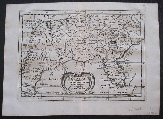
Florida.
Sanson d'Abbeville, Nicholas
A.d'Winter
Florida. Florida zoo als het van de Spaanschen en Franschen wordt bezeten. ... Amsterdam Francois Halma 1705
Copper engraved map of Florida by N. Sanson from Halma's
Algemeene Werelde BeschryvingVol. 3 Black and white; title in Dutch; verso blank; strapwork title cartouche.
This influential map shows the Spanish and French possessions in the southern part of the United States. The map extends from the southernmost part of Virginia to the coast of what is now Texas. When first introduced by Sanson in 1657, this map was the first to use the name
L. Eriein an atlas and to introduce several new rivers in Virginia. The French claims in the Carolinas are reasserted with the region named
Floride Francoise, despite the region not having had any French presence for nearly 100 years. The place name Caroline is not related to the future English colony of Carolina. Instead it is a confusion between the French
Fort Caroline on the St. Johns River, and Charlefort that was located near Port Royal. According to Burden, this is the third state of the map.
Published in Francois Halma's Dutch edition of A. Pherotee de la Croix's
Nouvelle Methode Pour Apprendre facilement la Geographie Universelle.
Dark impression; pin hole paper fault to upper right , below latitude 40.
Nicolas Sanson d'Abbeville.(1600-67),
' father of the French cartography' and founder of the Sanson firm. Atlas ' Cartes générales de toutes les parties du Monde', 1658-70 and a pocket atlas in 4 parts ( 1652-1705).
Sanson's small maps from A. Phérotée de la Croix's
Nouvelle Methode Pour Apprendre Facilement la Geographie Universelle,., first published in 1652 and engraved by A. Peyrounin, were copied several times by various map publishers. Johann David Zunners made copies of Sanson's maps for his German translation of
Die Gantze Erd-Kugel in 1679. Johannes Ribbius and Simon de Vries published copies in 1682 and 1683, with new maps engraved by Antoine d'Winter. The plates were later sold to Francois Halma, who used them in 1699 and then again in 1705 with the titles re-engraved in Dutch.
François Halma ( 1653 - 1722)
Dutch publisher/printer; dealer/auction house. Cartographer and publisher of maps, active in Utrecht, Amsterdam, Franeker and Leeuwarden.
Published 'Description de l'Univers' (1700); 'Algemene Wereldtbescrijving' (1705); 'Corpus Inscriptionum' (1707) and 'Lexicon Philosophicum' (1713).alma acquired many of the plates for Algemeene Weereld-Beschryving from Joannes Ribbius, who had enlisted the services of engraver Antoine de Winter to make copies of the maps in Nicolas Sanson's quarto atlases of the four continents. De Winter made very few geographical changes and maintained the attribution to Sanson on the newly engraved plates. Halma supplemented the Sanson maps with about a dozen new maps engraved in the same style as Sanson's, without any attribution on the maps, as well as 23 panoramic views of famous cities around the world.
Keoman: Hal 1; Phillips 528; Burden #546; Cumming (SE) #53. 178 by 255mm (7 by 10 inches).
ref: 3240
€500