Guyana.
Sanson d'Abbeville, Nicholas
A.d'Winter
Guyana. Guiana verdeelt Guina en Caribana.. Amsterdam Francois Halma 1705
Copper engraved map of Guyana by N. Sanson from Halma's
Algemeene Werelde BeschryvingVol. 3 Black and white; title in Dutch; verso blank; strapwork title cartouche.
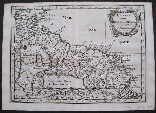
The map shows a large lake or inland sea
Lac, ou Mer que les Caribes appellent Parime les Iaoyi Roponowini.and located on its shores the mythical city of
El Doradoor
Manoa.
Lake Parime or
Lake Parimais a legendary lake located in South America. It was reputedly the location of the fabled city of
El Dorado,also known as
Manoa, much sought-after by European explorers. Repeated attempts to find the lake failed to confirm its existence, and it was dismissed as a myth along with the city. The search for
Lake Parimeled explorers to map the rivers and other features of southern Venezuela, northern Brazil, and southwestern Guyana before the lake's existence was definitively disproved in the early 19th century. Some explorers proposed that the seasonal flooding of the
Rupununi savannahmay have been misidentified as a lake. Recent geological investigations suggest that a lake may have existed in northern Brazil, but that it dried up some time in the 18th century. Both
"Manoa"(Arawak language) and
"Parime" (Carib language) are believed to mean
"big lake".This map appeared in A
lgemeene Weereld-Beschryving, nae de Rechte Verdeeling der Landschappen, Plaetsen, Zeeën, Rivieren, &c. Geographisch, Politisch, Historisch, Chronologisch en Genealogisch, a Dutch edition of A. Phérotée de la Croix's
Nouvelle Methode Pour Apprendre Facilement la Geographie Universelle,which first appeared in 1690. Dark impression.
Nicolas Sanson d'Abbeville.(1600-67),
' father of the French cartography' and founder of the Sanson firm. Atlas ' Cartes générales de toutes les parties du Monde', 1658-70 and a pocket atlas in 4 parts ( 1652-1705).
Sanson's small maps from A. Phérotée de la Croix's
Nouvelle Methode Pour Apprendre Facilement la Geographie Universelle,., first published in 1652 and engraved by A. Peyrounin, were copied several times by various map publishers. Johann David Zunners made copies of Sanson's maps for his German translation of
Die Gantze Erd-Kugel in 1679. Johannes Ribbius and Simon de Vries published copies in 1682 and 1683, with new maps engraved by Antoine d'Winter. The plates were later sold to Francois Halma, who used them in 1699 and then again in 1705 with the titles re-engraved in Dutch.
François Halma ( 1653 - 1722)
Dutch publisher/printer; dealer/auction house. Cartographer and publisher of maps, active in Utrecht, Amsterdam, Franeker and Leeuwarden.
Published 'Description de l'Univers' (1700); 'Algemene Wereldtbescrijving' (1705); 'Corpus Inscriptionum' (1707) and 'Lexicon Philosophicum' (1713).alma acquired many of the plates for Algemeene Weereld-Beschryving from Joannes Ribbius, who had enlisted the services of engraver Antoine de Winter to make copies of the maps in Nicolas Sanson's quarto atlases of the four continents. De Winter made very few geographical changes and maintained the attribution to Sanson on the newly engraved plates. Halma supplemented the Sanson maps with about a dozen new maps engraved in the same style as Sanson's, without any attribution on the maps, as well as 23 panoramic views of famous cities around the world.
Keoman: Hal 1; Phillips 528. 202 by 280mm (8 by 11 inches).
ref: 3247
€200