Ireland.
SANTINI, FRANCOIS.
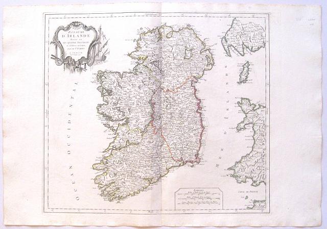
The Kingdom of Ireland "
Le Royaume d'Irelande divise en ses Quatres Provinces et subdivisé en Comtés Par le Sr Robert." Venice, Remondini, 1778
Copper engraved map of Ireland from Santini's "
Atlas universel dressé sur les meilleures cartes modernes". Original outline colour; verso blank.
The map By Giles, Robert de Vaugondy names the towns and counties of its day, whilst the outline colour is used to denote the four provinces., with part of the coasts of Wales and Scotland; the Isle of Man; part of the coast of North Devon and Lundy Island.
Black & white strapwork cartouche. Dark impression; printers crease to lower margin.
Francois [Francesco] Santini
was an Italian cartographer and map publisher based in Venice, who re-issued the works of Robert de Vaugondy, Homann's Heirs and De L'Isle.
Cartography in Italy was then at a rather low ebb, so Santini, essentially a publisher rather than a map-maker modelled his work on two of the leading practitioners of cartography in Europe, the French map-makers Gilles and Didier Robert de Vaugondy and their "
Atlas Universel" first published in 1758 and running to many editions; its commercial success led Santini, to commission a new set of plates, published between 1776-84, being almost exact copies of the original French maps to which were added new maps of Italy for the home market.
Robert de Vaugondy
Gilles Robert de Vaugondy (1688–1766), also known as
Le Sieur or
Monsieur Robert, and his son, Didier Robert de Vaugondy (c.1723–1786), were leading cartographers in France during the 18th century.
Gilles and Didier Robert De Vaugondy produced their maps and terrestrial globes working together as father and son. In some cases it is uncertain whether Gilles or Didier made a given map; Gilles often signed maps as
M.Robert, while Didier commonly signed his maps as
Robert de Vaugondy, or added
fils or
filio after his name.
In 1757, Gilles and Didier Robert De Vaugondy published the "
Atlas Universel." Remondini (fl. c. 1657 - 1861)
were a family of printers who worked originally based in Bassano del Grappa, near Venice.
Giovanni Antonio Remondini (1634-1711), the family patriarch, was born in Padua in 1634. In 1657, he took a home the main square of Bassano where he opened a shop drapes, wool, silk and iron tools. He also sold woodcuts of saints which proved popular with local farmers who believed they bought spiritual protection. When Giovanni died in 1711 his printing business fell into the hands of his son, Joseph Remondini. In 1750 Joseph expended the family business into Venice proper. Having several paper factories established by Giovanni Antonio, the Remondini were in a position to undercut competitors in Venice.
The Remondini employed a number of talented engravers, including Paolo Santini, an Abbot who specialized in sacred images as well as cartography. Their corpus includes several beautifully produced atlases, though, cartographically speaking, little in the way of original work. The family fell into decline following the Napoleonic invasions, finally closing their doors in 1861
Pedley, Bel et Utile: the Work of the Robert de Vaugondy Family of Mapmakers, 52. 480 by 542mm (19 by 21¼ inches).
ref: 3265
€250