MAPS & VIEWS
PRINTS
BOOKS
Touraine, France.
 Petrus Kaerius/ Pieter Van der Keere.
"Touraine, Turonensis Ducatus. " Amsterdam, Johannis Cloppenburgji. 1632
Petrus Kaerius/ Pieter Van der Keere.
"Touraine, Turonensis Ducatus. " Amsterdam, Johannis Cloppenburgji. 1632Copper engraved map of Touraine, France. from" Gerardi Mercatoris, Atlas sive Cosmographicae Meditationes de Fabrica mundi et fabricati figura, "Latin text to verso. Generally good impression, slightly weaker in the lower third; damp stain to upper margin; crease to lower right corner.
Keoman:Me200. 187 by 254mm (7¼ by 10 inches). €40
Verona, Italy.
 Petrus Kaerius/ Pieter Van der Keere.
"Verona Vicentiæ, et Patavi Ditiones. " "Veronia Principtus. " Amsterdam, Johannis Cloppenburgji. 1632
Petrus Kaerius/ Pieter Van der Keere.
"Verona Vicentiæ, et Patavi Ditiones. " "Veronia Principtus. " Amsterdam, Johannis Cloppenburgji. 1632Copper engraved map of Verona, from Lake Garda to the Gulf of Venice, from" Gerardi Mercatoris, Atlas sive Cosmographicae Meditationes de Fabrica mundi et fabricati figura, "Latin text to verso. Fair impression; damp stain to upper margin; wormhole just outside right scale; lower margin short 5-7mm.
.
Keoman:Me200. 192 by 262mm (7½ by 10¼ inches). €150
Waldeck, Germany.
 Petrus Kaerius/ Pieter Van der Keere.
"Waldeck Comitatus. " Amsterdam, Johannis Cloppenburgji. 1632
Petrus Kaerius/ Pieter Van der Keere.
"Waldeck Comitatus. " Amsterdam, Johannis Cloppenburgji. 1632Copper engraved map of the state of Waldeck, Germany. from" Gerardi Mercatoris, Atlas sive Cosmographicae Meditationes de Fabrica mundi et fabricati figura, "Latin text to verso. Good impression; light damp stain to upper margin.
Keoman:Me200. €50
Duchy of Westphalia, Germany.
 Petrus Kaerius/ Pieter Van der Keere.
"Westphalia Ducatus. " "Westphalia IIII Tabula. " Amsterdam, Johannis Cloppenburgji. 1632
Petrus Kaerius/ Pieter Van der Keere.
"Westphalia Ducatus. " "Westphalia IIII Tabula. " Amsterdam, Johannis Cloppenburgji. 1632Copper engraved map of the Duchy of Westphalia, Germany. from" Gerardi Mercatoris, Atlas sive Cosmographicae Meditationes de Fabrica mundi et fabricati figura, "Latin text to verso. Dark impression; damp stain to upper margin.
Keoman:Me200. 186 by 255mm (7¼ by 10 inches). €50
Westphalia, Germany.
 Petrus Kaerius/ Pieter Van der Keere.
"Westphaliæ tabula II. " Amsterdam, Johannis Cloppenburgji. 1632
Petrus Kaerius/ Pieter Van der Keere.
"Westphaliæ tabula II. " Amsterdam, Johannis Cloppenburgji. 1632Copper engraved map of the Paderborn. Lippe area of Westphalia, Germany. from" Gerardi Mercatoris, Atlas sive Cosmographicae Meditationes de Fabrica mundi et fabricati figura, "Latin text to verso. Good impression; damp stain to upper margin.
Keoman:Me200. 185 by 254mm (7¼ by 10 inches). €50
Duchy of Württemberg, Germany
 Petrus Kaerius/ Pieter Van der Keere.
"Wirtenberg ducatus. " "Ducatus Wirtemburgensis. " Amsterdam, Johannis Cloppenburgji. 1632
Petrus Kaerius/ Pieter Van der Keere.
"Wirtenberg ducatus. " "Ducatus Wirtemburgensis. " Amsterdam, Johannis Cloppenburgji. 1632Copper engraved map of the Duchy of Württemberg. Germany. from" Gerardi Mercatoris, Atlas sive Cosmographicae Meditationes de Fabrica mundi et fabricati figura, "Latin text to verso. Good impression; light damp stain and two spots to upper margin.
Keoman:Me200. 180 by 249mm (7 by 9¾ inches). €50
Saintonge, France.
 Petrus Kaerius/ Pieter Van der Keere.
"Xaintonge. " Amsterdam, Johannis Cloppenburgji. 1632
Petrus Kaerius/ Pieter Van der Keere.
"Xaintonge. " Amsterdam, Johannis Cloppenburgji. 1632Copper engraved map ofSaintonge, France. from" Gerardi Mercatoris, Atlas sive Cosmographicae Meditationes de Fabrica mundi et fabricati figura, "Latin text to verso. Fair impression; damp stain to upper margin.
Keoman:Me200. 186 by 252mm (7¼ by 10 inches). €40
Zurichgow, Switzerland.
 Petrus Kaerius/ Pieter Van der Keere.
"Zurichgow. " Amsterdam, Johannis Cloppenburgji. 1632
Petrus Kaerius/ Pieter Van der Keere.
"Zurichgow. " Amsterdam, Johannis Cloppenburgji. 1632Copper engraved map of Zurichgow, Switzerland, from" Gerardi Mercatoris, Atlas sive Cosmographicae Meditationes de Fabrica mundi et fabricati figura, "Latin text to verso. Dark impression; darker damp stain to upper marginand extreme edge of lower margin.
Keoman:Me200. 190 by 260mm (7½ by 10¼ inches). €50
Portugal.
 Petrus Kaerius/Pieter van der Keere. / Abraham Goos.
"Portugallia et Algarve. " Amsterdam, Joannis Janssonii. 1630
Petrus Kaerius/Pieter van der Keere. / Abraham Goos.
"Portugallia et Algarve. " Amsterdam, Joannis Janssonii. 1630Copper engraved map of Portugal and the Algarve. from the "Atlas Minor" of Gerhard Mercator. Dutch text to verso Dark impression; rust spot within the plate; slight show through of text from verso.
Koeman: Me197. 140 by 260mm (5½ by 10¼ inches). €120
View of the City of Copenhagen.
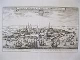 Copenhagen "Hafnia Metropolis et Portus Celeberrimus Daniæ._ Coppenhagen" Frankfurt MW Hoffman for Matthäusr Merian 1642-59
Copper engraved view of Copenhagen from Matthaus Merian's edition of Johann Ludwig, Gottfried's, "Historische Chronica oder Beshreibung der funerstein Geschten so sich von Abfang der Welt..". Black & white; verso blank.
The view shows the city from the sea. with many ships to the foreground. Key below of important buildings. Good impression; folded.
213 by 336mm (8½ by 13¼ inches). €350
Europe.
 Europe. "Europa Nova Delineatio" Frankfurt MW Hoffman for Matthäusr Merian 1642-59
Copper engraved map of Europe from Matthaus Merian's edition of Johann Ludwig, Gottfried's, "Historische Chronica oder Beshreibung der funerstein Geschten so sich von Abfang der Welt..". Black & white; verso blank.
Map of the continent of Europe decorated with ships and monsters to the Atlantic Good impression; folded; rust spot in the sea above Madiera islaands.
290 by 363mm (11½ by 14¼ inches). €400
View of the City of Lyon.
 Lyon "Lyon" Frankfurt MW Hoffman for Matthäusr Merian 1642-59
Copper engraved view of Lyon from Matthaus Merian's edition of Johann Ludwig, Gottfried's, "Historische Chronica oder Beshreibung der funerstein Geschten so sich von Abfang der Welt.". Black & white; verso blank.
The plate also appears in "Topographia Gallia " published by Casper Merian 1655.
The view from above the city shows the position of Lyon between the rivers Rhône and Saône the "Presqu'île" as the peninsular is known. Good impression ; even light toning; smudges to extreme lower blank margin.
242 by 350mm (9½ by 13¾ inches). €200
Lac Leman, Geneva and Savoy. One plate from Pierre Mortier's famous Wall map.
 Le Grand Teatre de la Guerre en Italie partie 3. 3. Partie continent Les Duchés de Savoye, de Genevois, de Chablis, Les Comtes et Morienne, de Tarentais et La Baronie de faussigny, Le Balliage de Gex et la Seigneurie de Geneve Amsterdam. Covens et Mortier c1741
Copper engraved map of Lake Geneva/ Lac Leman and part of Savoy from Covens & Mortier's " Nieuwe Atlas, Inhoudennde vier Gedeeltens der Waereld.. " Original full wash colour; verso blank.
Third sheet of Pierre Mortier's large wall map Le Grand Teatre de la Guerre en Italie (c. 1705) re issued by Covens & Mortier. [van Egmond mentions two copies of this issue by Covens and Mortier.]
The are covered has Lac Leman to the North and the mountains of Savoy to the South. Dark impression; bright full wash colour; printed on heavy paper; light toning; light spot to right blank margin.
Paper extended with extra fold to fit in Atlas.
Koeman III:Mor1; 54. ; van Egmond, Covens & Mortier, p.406-407, #31.2. 652 by 587mm (25¾ by 23 inches). €300
Panorama of Heidleberg.
 " Civitas Heidelbergsis, iuxta Neccarum sita, Palainatus metropolis.."
"Florentissimæ civitatis Heidelbergensis situs & genuina pictura, tam arcem quam reliquaillus loci insigniora ædificia pulchrè intuenti ob oculostatuens." Basileae Henricum Petri 1552.
2 sheet woodcut panorama of Heidelberg from Sebastian Münster's famous "Cosmographia". Black and white; Latin title and text to verso of first plate, second plate with blank verso..
The large panorama on two double pages, un-joined, shows the famous university city from across the river Neckar.
The major buildings are identified in the plate. 2 coats of arms on shields to the sky. 2 double pages, un-joined; good impression;slight show through of title from verso on sheet 1; small hole to upper and lower margins at centre fold of each sheet from binding; light water stain to upper edge of blank margin of sheet 1 and light water stain to lower right corner;short tear to upper blank margin of sheet 2, repaired to verso; light stain to lower left, on river bank, of sheet 2. Guards to verso of each sheet at centre fold .
254 by 720mm when joined(10 by 28¼ inches). €400
Panorama of Worms.
 " Civitas Wormaciencis, olim Vangionum urbs dicta...."
"Vetusttisima Vangionum civits, quam hodie Wormaciam vocant. sita ad rhenum in littore Gallico, expressa hic iuxta formann quam nostro habit ævo." Basileae Henricum Petri 1552.
2 sheet woodcut panaroma of Worms from Sebastian Münster's famous "Cosmographia". Black and white; Latin title and text to verso of first plate, second plate with blank verso..
The large panorama on two double pages, un-joined, shows the city from the banks of the river Rhine.
The major buildings are identified in the plate. Coats of arms on shield held by a dragon to the sky. Monogram of engraver "HSD".
A pre-Roman foundation, Worms was the capital of the kingdom of the Burgundians in the early 5th century and hence the scene of the medieval legends referring to this period, notably the first part of the Nibelungenlied. Worms has been a Roman Catholic bishopric since at least 614, and was an important palatinate of Charlemagne. Worms Cathedral is one of the Imperial Cathedrals and among the finest examples of Romanesque architecture in Germany. Worms prospered in the High Middle Ages as an Imperial Free City. Among more than a hundred Imperial Diets held at Worms, the Diet of 1521 (commonly known as the Diet of Worms) ended with the Edict of Worms in which Martin Luther was declared a heretic. 2 double pages, un-joined; good impression;slight show through of title from verso on sheet 1; small hole to upper and lower margins at centre fold of each sheet from binding; light stain/ toning by church of
S.Johannes; 2 rust marks ro lower corners of sheet 1.Guards to verso of each sheet at centre fold .
254 by 720mm when joined(10 by 28¼ inches). €300
Panorama of Vienna.
 "Anno Domini 1548. Viena Austriæ Hunc Habuait Situm." "Civitas Vienensis, Urbs metropolitana..."
"Vienna Austriæ metropolis, urbs toto orbe notissima celebratissima que. unicum hodie in Oriente contra sæuissimum Turcam invictum propugnaculum & fortalicum, expressa ad nostri æqum habet figuram." Basileae Henricum Petri 1552.
2 sheet woodcut panorama of Vienna from Sebastian Münster's famous "Cosmographia". Black and white; Latin title and text to verso of first plate, second plate with blank verso..
The large panorama on two double pages, un-joined, was engraved by Hans Rudolph Manuel Deutsch and Heinrich Holzmuller.[ both monograms appear in the second sheet, along with the date 1548 ] after a view by Wolfgang Lazius.
The major buildings are identified in the plate. Large decorative banner title to the sky, and coat of arms. 2 double pages, unjoined; good impression; side margins trimmed just entering plate [could be re margined]; small hole to upper and lower margin from binding; light water stain to lower blank margin of sheet 1and short upper centre fold split , repaired to verso; small rust mark to lower centre fold of sheet 2 and vertical crease to right side. Guards to verso of each sheet at centre fold .
224 by 765mm [when joined](8¾ by 30 inches). €1000
Bohemia, Czech Republic.
 "Bohemiæ descriptio iuxta insignores eius civitas & oppida.." " Bohemi Ciregnita tabula...." Basileae Henricum Petri 1552.
Double page woodcut map of Bohemia from Sebastian Münster's famous "Cosmographia". Black and white; Latin title to verso.
The map shows the area of Bohemia , now part of the Czech Republic. small key to lower right corner. Good impression; small hole at top centre fold above title and at lower centre fold in blank margin[ from former binding];crease to lower centre fold; old ink annotations to right blank margin.
255 by 353mm (10 by 14 inches). €150
Florence.
 "Florentia nobilissima Hethruriæiutas, deformata ad nostra tempora." " Civitas Florentina Hetruscorum metropolis,..." Basileae Henricum Petri 1552.
Double page woodcut view of Florence from Sebastian Münstar's famous "Cosmographia". Black and white; Latin title to verso.
Early woodcut view of the city of Florence, from across the river Arno, looking towards the old city. Good impression; minor show through of text from verso; slight creasing at centre fold , small hole to upper and lower margin from binding.
222 by 358mm (8¾ by 14 inches). €700
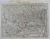
Poland and Hungary, Central Europe
 "Polonia et Ungariae Nova Descriptio." " Poloniae Et Ungariae Descriptionem...." Basileae Henricum Petri 1552.
Double page woodcut map of Central Europe, Poland & Hungary from Sebastian Münster's famous "Cosmographia". Black and white; Latin title to verso.
The map shows the area of Central Europe: Poland, White Russia down to the Crimea; Hungary and part of Bosnia and Bulgaria, with the course of the Danube to the Black Sea. Good impression; small hole at top centre fold above title and at lower centre fold in blank margin[ from former binding]; slight creasing at centre fold; minor chips to edges.
255 by 342mm (10 by 13½ inches). €400
Schwaben & Bavaria, Germany
 "Sueviae et bavariae Descriptio." " Suevia et Bavariae Particularum descriptioem..." Basileae Henricum Petri 1552.
Double page woodcut map of Schwaben and Bavaria from Sebastien Münster's famous "Cosmographia". Black and white; Latin title to verso. Good impression; tiny holes from former binding to upper and lower blank margins at centre fold.
256 by 342mm (10 by 13½ inches). €100
The Roman Ampitheatre of Verona
 "Theatrum Veronese: 1549." " Figura theatri Veronensis, quum adhuc integrum & perfectum asset. Hodie ruinæ eius extant." Basileae Henricum Petri 1552.
Double page woodcut view of the ampitheatre at Verona from Sebastien Münster's famous "Cosmographia". Black and white; Latin title to verso.
Early woodcut view of the famous "rose "ampitheatre at Verona drawn by Hans Rudolph Manuel Deutsch. Title in large decorative banner; text below image.
Completed around 30 AD, it is the third largest in Italy after Rome's Colosseum and the arena at Capua. It measures 139 metres long and 110 metres wide, and could seat some 25,000 spectators in its 44 tiers of marble seats. The ludi (shows and gladiator games) performed within its walls were so famous that they attracted spectators from far beyond the city. The current two-story façade is actually the internal support for the tiers; only a fragment of the original outer perimeter wall in white and pink limestone from Valpolicella, with three stories remains.The interior is very impressive and is virtually intact, and has remained in use even today for public events, fairs, theatre and open-aired opera during warm summer nights. Good dark clear impression; minor show through of text from verso; slight spotting to lower margin; small binding hole to centre of upper margin; short centre fold split to lower margin, far from image, repaired to verso..
201 by 361mm (8 by 14¼ inches). €250
Bird's Eye Plan of Amsterdam.
 Amsterdam. Basileae Henricum Petri 1552.
Woodcut half page bird's eye plan of Amsterdam engraved by Heinrich Holzmüller from Sebastian Münster's famous "Cosmographia". Black and white; set above Latin text with text and vignette to verso.
The map is after a woodcut by Cornelis Anthonisz, 1544. The text below however describes Rotterdam and continues to the verso where there is a woodcut vignette of Erasmus after the porrait by Hans Holbein the Younger . Good impression; some pencil underlining to text.
153 by 178mm (6 by 7 inches). .Full page:318x210mm €100
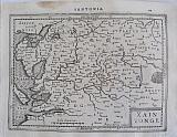
Geneva, Switzerland.
 Civitas Genevësis.. " Clarissiniæ civitatis Genevensis situs & figuratio, latusque eius meridianum.." Basileae Henricum Petri 1552.
Double page woodcut view of Geneva from Sebastian Münster's famous "Cosmographia". Black and white; Latin title to verso.
The woodcut view shows the city from across Lake Geneva/ Lac Léman with the covered bridge joining the two parts of the city.
Coat of arms to upper left corner ; text below. Good dark impression; minor show through of text from verso; small hole to upper and lower margin from binding; light spotting to centre of view & light damp stain to lower blank margin, below text; lower centre fold split, repaired to verso; old ink under linings and corrections to text.
154 by 355mm (6 by 14 inches). €200
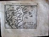
Abruzzo, Italy.
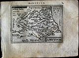 Phillip Galle.
"Abruzzo" "Aprutium. " Antwerp Joannem Bapt. Vrientium/ Vrients. 1601
Phillip Galle.
"Abruzzo" "Aprutium. " Antwerp Joannem Bapt. Vrientium/ Vrients. 1601Copper engraved minature map by Phillip Galle of Abruzzo, from" Epitome theatri Orteliani praecipuarum orbis regionum delinaetiones. . Editio ultima" Latin text to verso, describing the succeeding map. . Dark impression, overall toning.
Koeman Ort58; Phillips 413; 78 by 108mm (3 by 4¼ inches). €70
Anjou, France.
 Phillip Galle.
"Aniou. " "Andegavensis Ducatus" Antwerp Joannem Bapt. Vrientium/ Vrients. 1601
Phillip Galle.
"Aniou. " "Andegavensis Ducatus" Antwerp Joannem Bapt. Vrientium/ Vrients. 1601Copper engraved minature map by Phillip Galle of Anjou, France, from" Epitome theatri Orteliani praecipuarum orbis regionum delinaetiones. . Editio ultima" Latin text to verso, describing the succeeding map. . Dark impression, overall toning, light foxing to blank margins; one darker spot to lower blank margin
Koeman Ort58; Phillips 413; 81 by 105mm (3¼ by 4¼ inches). €30
Principality of Orange, France.
 Phillip Galle.
"Auraicus Princ. " "AuRaicus Principatus. " Antwerp Joannem Bapt. Vrientium/ Vrients. 1601
Phillip Galle.
"Auraicus Princ. " "AuRaicus Principatus. " Antwerp Joannem Bapt. Vrientium/ Vrients. 1601Copper engraved minature map by Phillip Galle of the Principality of Orange, Southern France, from" Epitome theatri Orteliani praecipuarum orbis regionum delinaetiones. . Editio ultima" Latin text to verso, describing the succeeding map. . Dark impression; overall toning; light foxing/staining to blank margins; printed crooked on the page.
Koeman Ort58; Phillips 413; 75 by 105mm (3 by 4¼ inches). €30
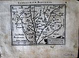
Blois, France.
 Phillip Galle.
"Blesiense Territorium. " Antwerp Joannem Bapt. Vrientium/ Vrients. 1601
Phillip Galle.
"Blesiense Territorium. " Antwerp Joannem Bapt. Vrientium/ Vrients. 1601Copper engraved minature map by Phillip Galle of Blois, France, from" Epitome theatri Orteliani praecipuarum orbis regionum delinaetiones. . Editio ultima" Latin text to verso, describing the succeeding map. . Dark impression; overall toning; light foxing/staining to blank margins.
Koeman Ort58; Phillips 413; 81 by 110mm (3¼ by 4¼ inches). €30
Brandenberg, Germany.
 Phillip Galle.
"Brandenbergens. Marcha. " "Brandenburg. Marchionatus. " Antwerp Joannem Bapt. Vrientium/ Vrients. 1601
Phillip Galle.
"Brandenbergens. Marcha. " "Brandenburg. Marchionatus. " Antwerp Joannem Bapt. Vrientium/ Vrients. 1601Copper engraved minature map by Phillip Galle of Brandenberg, Germany, from" Epitome theatri Orteliani praecipuarum orbis regionum delinaetiones. . Editio ultima" Latin text to verso, describing the succeeding map. . Dark impression, overall toning, light foxing to blank margins.
Koeman Ort58; Phillips 413; 78 by 107mm (3 by 4¼ inches). €30
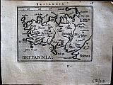
Brittany, France.
 Phillip Galle.
"Brittannia. " Antwerp Joannem Bapt. Vrientium/ Vrients. 1601
Phillip Galle.
"Brittannia. " Antwerp Joannem Bapt. Vrientium/ Vrients. 1601Copper engraved minature map by Phillip Galle of Brittany, France, from" Epitome theatri Orteliani praecipuarum orbis regionum delinaetiones. . Editio ultima" Latin text to verso, describing the succeeding map. . Dark impression, overall toning, light foxing to blank margins; printed slightly crooked on page. upper margin short6-8mm.
Koeman Ort58; Phillips 413; 78 by 107mm (3 by 4¼ inches). €50
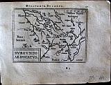
Duchy of Burgundy, France.
 Phillip Galle.
"Burgundiae Ducatus. " Antwerp Joannem Bapt. Vrientium/ Vrients. 1601
Phillip Galle.
"Burgundiae Ducatus. " Antwerp Joannem Bapt. Vrientium/ Vrients. 1601Copper engraved minature map by Phillip Galle of the Duchy of Burgundy, France, from" Epitome theatri Orteliani praecipuarum orbis regionum delinaetiones. . Editio ultima" Latin text to verso, describing the succeeding map. . Dark impression; overall toning; light foxing/staining to blank margins.
Koeman Ort58; Phillips 413; 77 by 106mm (3 by 4¼ inches). €30
Company: Bryan, Mary Louise.
Address: Ag. Andrianoy 92 , 21 100 Nafplio, Greece.
Vat No: EL 119092581