MAPS & VIEWS
PRINTS
BOOKS
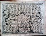
Crete after Ptolemy.
 Tabula Neoterica Cretae sive Candiæ. "Tabula nova Candiæ." Vienne, Daupniné Gaspar Trechsel, 1541
Black and white woodcut map of Crete by Laurent Fries from "Claudii Ptolemaei Alexandrini Geographicae Enarrationis, Libri Octo ... Prostant Lugduni apud Hugonem a Porta. M. D. XLI." Latin text to verso.
The map is from the second edition edited by Michael Villanovanus known as Servetus, the woodblock is the same as that used for the editions of 1522 & 1535. the difference from the previous editions can be seen in the plain letterpress title. Dark impression; dampstain to upper margin; some soiling and spotting ; hole [10mm] at lower centre fold just entering image due to stitching with others in lower blank margin [10mm & 2mm].
Shirley T.PTOL 7g; Adams P 2226; Phillips 336; Sabin 66485; Zacharakis 2801. 278 by 455mm (11 by 18 inches). €2000
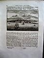
Crete with a Prospect, Panoramic view of Iraklion.
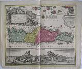 The island of Crete and the adjacent islands of the Aegean with the new island of Santorini ... "Insuls Creta nunc Candia in sua IV Territoria distinicta, cum aliqoud adjacentibus Ægei maris Insulis imprimis Nova Santorini insula modo ante XXVII annos ex abysso marsi emersa..."
"Creta nunc Candia" Augsburg, Lotter Conrad Tobias 1772
Copper engraved map of Crete with View of Iraklion after Seutter from Lotters "Atlas Novus." . Original old colour; verso blank
The map shows the island of Crete, taken from the Homann map of 1712 { Zacharakis 1641/1879] with the a long text beside the newly emerged island at Santorini following the volcanic eruption of 25th May 1707: "In 1707, activity began again, the small when two cones appeared. They were called Aspronisi and Macronesi. Those were united in the course of the following five years by an island which formed between Palea and Small Kameni, much larger and higher then either and was called Nea (New) Kameni .This island, is the youngest island in Greece."[Santorini Living ]
Below is a panaromic view of Iraklion, black & white as issued.
The map was first published by Lotter's father-in-law Matthaüs Seutter in his "Atlas Novus" in 1728 who took the lower part of Homann's map re-engraved the cartouche and text and added the scale to the right half of the map. Seutter then added the panoramic view below the map. . Seutter is renowned for his detailed plans and prospects of cities which appeared in his "Atlas Novus".
Decorative title cartouche with imprint of Lotter replacing that of Seutter. The vignette shows a Janissary overseeing 2 turkish sailors loading cargo; grapes and wine barrels adorn the pedestal; in the background a large sailing ship and on the mountains a herd of Kri-Kri the indiginous capricorn of Crete.
The view with title to sky. Good dark impression; 4 small worm holes near title of view, 2 more near seashore of castle. The map was bound in an atlas at he left margin, but folded at centre [ hence the pairs of wormholes]; crease to left side up to the cartouche and also to upper right corner; light soiling to margins, ink stamp removed to lower right margin. A good example of a scarce prospect/map.
Zacharakis:2103/1308 500 by 561mm (19¾ by 22 inches). €1500
Iraklion, Crete.
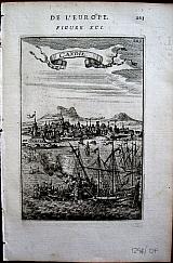 "Candie". Paris Thierry. Denys. 1683
Copper engraved view of Iraklion, called by the Venetians "Candia" from Mallet's "Description de l'Univers" 1st edition. Text to verso. Dark impression.
148 by 100mm (5¾ by 4 inches). €80
Crete.
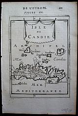 "Isle de Candie" Paris Thierry. Denys. 1683
Copper engraved map of Crete [ callled Candia by the Venetians] with Milos, Sikino Santorini etc to the North, from Mallet's "Description de l'Univers" 1st edition. Text to verso. Dark impression.
Zacharakis 2152/1416 153 by 112mm (6 by 4½ inches). €80
Crete.
 "Isle de Crete". Paris Thierry. Denys. 1683
Copper engraved map of Crete with Milos, Sikino etc to the North, from Mallet's "Description de l'Univers" 1st edition. Text to verso. Decorative title cartouche. Dark impression.
Zacharakis 2151/1415 145 by 98mm (5¾ by 3¾ inches). €100
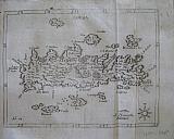
Crete, Greece.
 Petrus Kaerius/ Pieter Van der Keere.
"Candia. " Amsterdam, Johannis Cloppenburgji. 1632
Petrus Kaerius/ Pieter Van der Keere.
"Candia. " Amsterdam, Johannis Cloppenburgji. 1632Copper engraved map of Crete/ Candia, from" Gerardi Mercatoris, Atlas sive Cosmographicae Meditationes de Fabrica mundi et fabricati figura, "Latin text to verso. Dark impression; evenly toned; some dampstaining to blank margins; dark damp stain to upper margin; some spotting; wormtrack 6mm. to right scale.
Keoman:Me200; Zacharakis: 2282/1503. 187 by 253mm (7¼ by 10 inches). €300
Crete, and Islands.
 Petrus Kaerius/Pieter van der Keere. / Abraham Goos.
"Candia. " "Crete, ou Candie, Corfu, Zante &c. " Amsterdam, Joannis Janssonii. 1628
Petrus Kaerius/Pieter van der Keere. / Abraham Goos.
"Candia. " "Crete, ou Candie, Corfu, Zante &c. " Amsterdam, Joannis Janssonii. 1628Copper engraved map of the island of Crete, with 6 small maps of Greek islands above, namely: Corfu/Kerkyra, Zante/ Zakinthos, Milo, Nicsia/Naxos. Santorini/Thira and Scarpanto/Karpathos. from the "Atlas Minor" of Gerhard Mercator. French text to verso. Dark impression; very small worm hole to lower, blank margin, evidence of a crack in the plate to right scale of Crete.
Koeman: Me195; Zacharakis:2242/1472. 143 by 199mm (5¾ by 7¾ inches). ` €250
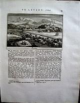
The Island of Crete.
 Crete. "Candia" Wien, Nurnberg, Peter Conrad Monath. 1735
Copper engraved map of Crete from Angelicus Maria Myller's "Peregrinus in Jerusalem..". Modern hand colour; verso blank.
The map shows the island with the city of Iraklion- Candia dominating the north coast; with the mythical Labarynth marked in the centre of the island; the nearby small islands are shown; galleons decorate the sea. Good impression; modern habd colour; mounted.
Zacharakis /1594 152 by 190mm (6 by 7½ inches). €450
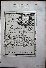
Ancient Crete with Corsica, Sardinia & the Ionian islands.
 Creta; Sardinia; Corsica; Insula Maris Ionii. "Creta Iouis Magni, medio iacet insula ponto." "Antverpiæ"/Antwerp.. "Apud Joannem Bapt. Vrintium"Jan Baptist Vrients. 1601
Copper engraved map of Ancient Crete from "The Parergon " of Ortelius' "Theatrum Orbis Terrarum" 1601 edition; black & white. Latin text to verso.
The map shows ancient Crete in the lower half with 3 smaller maps above of Corsica, the Ionian Islands & Sardinia, in ancient times. Good dark impression; some soiling and spotting mainly to blank margins; light creasing to centre fold and two horizontal creases to lower blank margin; very short tears to lower edge and corners somewhat ragged.
Van de Krogt :3; .Koeman: Ort34 xxix [7P]; Zacherakis: 2504/1621; van den Broecke:217d. 340 by 490mm (13½ by 19¼ inches). €750
Town plan of Iraklion, Crete.
 Peeters, Jacques excudit. .
Iraklion. "Candia." Antwerp Peeters, Jacques. after1685
Peeters, Jacques excudit. .
Iraklion. "Candia." Antwerp Peeters, Jacques. after1685Decorative copper engraved town plan by Jacques Peeters of Candia- Iraklion from "Description Des Principales des Villes. . . . " , Modern hand colour; verso blank.
The plate is decorated with numerous ships to the sea, banner title "Candia" above ; Key below. Dark impression.; mounted.
Blackmer/Navari: 1276; Laor 1091-1093, Koeman III p94 (note). 150 by 211mm (6 by 8¼ inches). €250
Crete.
 Delinea Fran Placentia
 Sculpsit Fran.Guianottus Mut. "Candia" Modena "Eredi Soliani stampatori Ducali" 1688
Copper engraved map of Crete, from "L'Egeo redivivo , o' sia choragraphia dell' Archipelago". Signed in the plate F. Placentia. Verso blank. Good impression but slightly faint to upper scale; some slight toning: folded.
Zacharakis :2630/1694 140 by 185mm (5½ by 7¼ inches). €500
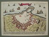
Scarce Seventeenth Century T own Plan of Iraklion with a map of the Island of Crete.
 The Island of Candia [Crete] with Candia capital city of the Island of the same name. "Candie ville Métropolitaine de l'isle de même nom " & " Isle de Candie." Paris P du Val. " Chez l'Auteur, en l'Isle du Palais , sur Quay de l'Horologe, au coin de la rue Harlay." 1667
Copper engraved map and town plan of Crete and Iraklion, by Pierre du Val from his Atlas " Cartes De Géographie Les Plus Nouvelles Et Les Plus Fidèles." Modern colour; verso blank. 2 on 1 plate.
A scarce sheet from du Val's atlas, the upper plan showing the fortifications of the city of Iraklion; the map showing the divisions of the island with the islands of Milos, Sikinos, Folegandros, Ios, Santorini, Anafi and Astipalea, to the north. Compass rose to sea. Good impression; odd spots; dampstain to edge of upper margin; remargined to sides with paper of the same atlas; numerous folds and creases; lower map with long crease through island with some holes, backed at some time with old paper [ the description of Candia from the same atlas, but sadly with the text face down so verso blank]. Condition not perfect but acceptable for such a scarce map.
This edition not in Zacharakis [ Zacharakis:3558/2314 later edition] 510 by 390mm (20 by 15¼ inches). Candie Town:256x390mm; Island254x390mm. €600
Scarce Miniature Bird's eye View of Chania/ Xania, Crete.
 Chania/Xania Canea in Candia Nuremberg Sandrardt Jacob 1686
Copper engraved miniature bird's eye view of Chania, in Crete from Sandrart's: Kurtze Beschreibung Von Dem Ursprung/ Aufnehmen/ Gebiete/ und Regierung der Weltberühmten Republick Venedig/ Mehrentheils den Jahren nach/ und in Form einer kurtzen Chronick verabfasset/ Wie auch eine kurtze Beschreibung der vornehmsten Griechischen Provintz und Pen-Insel Morea.
[Description of the origin/absorption/territories/and government of the world-famous Republic of Venice/mostly over the years/and written in the form of a short chronicle/as well as a short description of the most distinguished Greek province and pen island of Morea.]
Black and white, verso blank.
The bird's eye view shows the fortifications of the old city, with Suda in the distance. Lower margin short.
67 by 110mm (2¾ by 4¼ inches). €200
Scarce Miniature Map of Crete.
 Crete. Candia Insula. Nuremberg Sandrardt Jacob 1686
Copper engraved miniature map of Crete from Sandrart's: Kurtze Beschreibung Von Dem Ursprung/ Aufnehmen/ Gebiete/ und Regierung der Weltberühmten Republick Venedig/ Mehrentheils den Jahren nach/ und in Form einer kurtzen Chronick verabfasset/ Wie auch eine kurtze Beschreibung der vornehmsten Griechischen Provintz und Pen-Insel Morea.
[Description of the origin/absorption/territories/and government of the world-famous Republic of Venice/mostly over the years/and written in the form of a short chronicle/as well as a short description of the most distinguished Greek province and pen island of Morea.]
Black and white, verso blank. Left margin short.
Zacharakis:3100/2053 115 by 65mm (4½ by 2½ inches). €300
Scarce Miniature View of Heraklion/ Iraklion Crete.
 Heraklion La Citta di Candia Nuremberg Sandrardt Jacob 1686
Copper engraved miniature view of Heraklion in Crete from Sandrart's: Kurtze Beschreibung Von Dem Ursprung/ Aufnehmen/ Gebiete/ und Regierung der Weltberühmten Republick Venedig/ Mehrentheils den Jahren nach/ und in Form einer kurtzen Chronick verabfasset/ Wie auch eine kurtze Beschreibung der vornehmsten Griechischen Provintz und Pen-Insel Morea.
[Description of the origin/absorption/territories/and government of the world-famous Republic of Venice/mostly over the years/and written in the form of a short chronicle/as well as a short description of the most distinguished Greek province and pen island of Morea.]
Black and white, verso blank. Lower margin short.
69 by 101mm (2¾ by 4 inches). €200
Scarce Miniature View of Rethymnon, Crete.
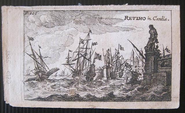 Rethymnon Retimo in Candia Nuremberg Sandrardt Jacob 1686
Copper engraved miniature view of Suda, in Crete from Sandrart's: Kurtze Beschreibung Von Dem Ursprung/ Aufnehmen/ Gebiete/ und Regierung der Weltberühmten Republick Venedig/ Mehrentheils den Jahren nach/ und in Form einer kurtzen Chronick verabfasset/ Wie auch eine kurtze Beschreibung der vornehmsten Griechischen Provintz und Pen-Insel Morea.
[Description of the origin/absorption/territories/and government of the world-famous Republic of Venice/mostly over the years/and written in the form of a short chronicle/as well as a short description of the most distinguished Greek province and pen island of Morea.]
Black and white, verso blank. Upper margin short.
69 by 101mm (2¾ by 4 inches). €180
Scarce Miniature View of Suda, Crete.
 Suda. Ports Suda paleo in Candia Nuremberg Sandrardt Jacob 1686
Copper engraved miniature view of Suda, in Crete from Sandrart's: Kurtze Beschreibung Von Dem Ursprung/ Aufnehmen/ Gebiete/ und Regierung der Weltberühmten Republick Venedig/ Mehrentheils den Jahren nach/ und in Form einer kurtzen Chronick verabfasset/ Wie auch eine kurtze Beschreibung der vornehmsten Griechischen Provintz und Pen-Insel Morea.
[Description of the origin/absorption/territories/and government of the world-famous Republic of Venice/mostly over the years/and written in the form of a short chronicle/as well as a short description of the most distinguished Greek province and pen island of Morea.]
Black and white, verso blank. Upper margin short.
69 by 101mm (2¾ by 4 inches). €150
Iraklion/ Candia, Crete.
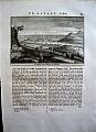 After Claude Aubriet
"Candie, du chemin de Retimo" Amsterdam Janssoons van Waesberge. 1737
After Claude Aubriet
"Candie, du chemin de Retimo" Amsterdam Janssoons van Waesberge. 1737Copper engraved view of Iraklion/Candia, Crete. Set in a page of Dutch text [page17 Vol1. ]
from Tournefort's "Beschryving van eene Reize naar de Levant" ["Relation D'Un Voyage du Levant"] 1737 [5th edition]. Single page, large 4to, text to verso. Dark impression, with very large margins.
Blackmer/Navari 1318[1st edition] 105 by 156mm (4¼ by 6¼ inches). €120
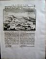
Chania, Crete.
 After Claude Aubriet
"Montaignes Blanche" Amsterdam Janssoons van Waesberge. 1737
After Claude Aubriet
"Montaignes Blanche" Amsterdam Janssoons van Waesberge. 1737Copper engraved view of Chania, Crete. Set in a page of Dutch text[page8, Vol1. ]
from Tournefort's "Beschryving van eene Reize naar de Levant" ["Relation D'Un Voyage du Levant"] 1737 [5th edition]. Single page, large 4to, text to verso. Dark impression, with very large margins.
Blackmer/Navari 1318[1st edition] 100 by 152mm (4 by 6 inches). €150
Rethymnon, Crete.
 After Claude Aubriet
"Retimo" Amsterdam Janssoons van Waesberge. 1737
After Claude Aubriet
"Retimo" Amsterdam Janssoons van Waesberge. 1737Copper engraved view of Rethymnon, Crete. Set in a page of Dutch text [page15, Vol1. ]
from Tournefort's "Beschryving van eene Reize naar de Levant" ["Relation D'Un Voyage du Levant"] 1737 [5th edition]. Single page, large 4to, text to verso. Dark impression, very large margins.
Blackmer/Navari 1318[1st edition] 110 by 162mm (4¼ by 6½ inches). €150
Gortys/ Gortyna, Crete.
 After Claude Aubriet
"Ruines de Gortyne" Amsterdam Janssoons van Waesberge. 1737
After Claude Aubriet
"Ruines de Gortyne" Amsterdam Janssoons van Waesberge. 1737Copper engraved view of the ruins of Gortys. Crete. Set in a page of Dutch text [page25, Vol 1. ]
from Tournefort's "Beschryving van eene Reize naar de Levant" ["Relation D'Un Voyage du Levant"] 1737 [5th edition]. Single page, large 4to, text to verso. Gortys was capital of Crete during the Roman period, and also the first city in Crete to adopt Christianity; it was destroyed by the Arabs in 828AD. Dark impression. with wide margins.
Blackmer/Navari 1318[1st edition] 105 by 163mm (4¼ by 6½ inches). €40
Company: Bryan, Mary Louise.
Address: Ag. Andrianoy 92 , 21 100 Nafplio, Greece.
Vat No: EL 119092581