MAPS & VIEWS
PRINTS
BOOKS
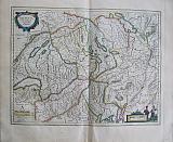
Argow and the Lakes of Zurich, Switzerland.
 Argow. "Argow cum partie merid. Zurichgow Auctore Ger. Mercatore " Amsterdam Apud Guiljelmum et Joahannem Blaeu. 1647
Original coloured, copper engraved map of Argow and the lakes of Zurichgow after Mercator, from volume 1 of Joan Blaeu's "Le theatre du Monde ou Nouvel Atlas." Double page; folio; French text to verso. Original colour;printed crooked on the page; light toning; spot to blank margin and lower right corner of sheet torn.
Koeman1, Bl 16A [137(Ooo)] 384 by 500mm (15 by 19¾ inches). €350
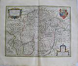
Switzerland..
 Le Pays de Suisses. "Helvetia.cumfinitimis regionibus confœderatis" Amsterdam Apud Guiljelmum et Joahannem Blaeu. 1647
Original coloured, copper engraved map of Switzerland after Mercator, from volume 1 of Joan Blaeu's "Le theatre du Monde ou Nouvel Atlas." Double page; folio; French text to verso. Original colour; a few spots to blank margins.
Koeman1, Bl 16A [135(Lll)] 380 by 504mm (15 by 19¾ inches). €500
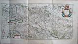
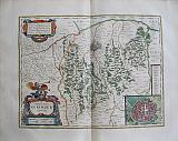
Wiflispurgegow, Switzerland..
 Wiflispurgergow. "Das Wiflispurgergow. Gerardo mercatore Auctore" Amsterdam Apud Guiljelmum et Joahannem Blaeu. 1647
Original coloured, copper engraved map of South West Switzerland after Mercator, from volume 1 of Joan Blaeu's "Le theatre du Monde ou Nouvel Atlas." Double page; folio; French text to verso.
The map shows the area of South West Switzerland from the Jura in the west , with Lake Leman , across to Lake Thun in the East. Original colour; ligh toning; tear to lower blank margin [repaired].
Koeman1, Bl 16A [136(Nnn)] 384 by 500mm (15 by 19¾ inches). €350
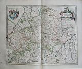
Upper Bavaria, Oberpfalz, Germany.
 De Paaitinat de Baviere "Palitanatus Bavariæ" Amsterdam Apud Guiljelmum et Joahannem Blaeu. 1647
Original coloured, copper engraved map of the region of Upper Bavaria, from volume 1 of Joan Blaeu's "Le theatre du Monde ou Nouvel Atlas." Double page; folio; French text to verso.
The map shows the Oberpfalz or Upper Bavaria ,which was at on time united with the Rhenish Palatinate,.
Tthe Danube runs across the lower part of the map
Decorative title cartouche and coat of arms. Original colour;light spotting and smudges to margins.
Koeman1, Bl 16A [130(Ddd)] 385 by 508mm (15¼ by 20 inches). €350
Saxonia Germany.
 Description de Saxe, Lausnits, et Meissen. "Saxonia Superior, cum Lusatia et Misnia." Amsterdam Apud Guiljelmum et Joahannem Blaeu. 1647
Original coloured, copper engraved map of Saxonia from volume 1 of Joan Blaeu's "Le theatre du Monde ou Nouvel Atlas." Double page; folio; French text to verso.
Decorative titleBanner across the top of the map.
The map shows the area of Halle, Leipsig and Meissen with Prague and part of Bohemia. Original colour; short centrefold split at lower edge [repaired].
Koeman1, Bl 16A [125(Ii]) 393 by 510mm (15½ by 20 inches). €300
Mansfeld, Germany.
 Description du Comte de Mansfeld. "Mansfedia Comitatus Auctore Tilemanno Stella Sig." Amsterdam Apud Guiljelmum et Joahannem Blaeu. 1647
Original coloured, copper engraved map of Mansfeld from volume 1 of Joan Blaeu's "Le theatre du Monde ou Nouvel Atlas." Double page; folio; French text to verso.
Decorative title cartouche surrounde by putti; coat of arms. Original colour.
Koeman1, Bl 16A [124(Hh0] 410 by 496mm (16¼ by 19½ inches). €300
Alsace. France.
 L'Alsace. "Alsatia landgravitas cum Suntgoia et Brisgoia. Ger. Mercatore Auctore." Amsterdam Apud Guiljelmum et Joahannem Blaeu. 1647
Original coloured, copper engraved map of Alsace, from volume 1 of Joan Blaeu's "Le theatre du Monde ou Nouvel Atlas." three page; folio; French text to verso.
Decorative title cartouche surmounted by coat of arms. Original colour; two sheets joined; folded.
Koeman1, Bl 16A [139(Gqq)] 400 by 804mm (15¾ by 31¾ inches). €400
The Bishopric of Cologne, Germany.
 L'Archevesche de Coloigne "Coloniensis Archiepiscpatus." Amsterdam Apud Guiljelmum et Joahannem Blaeu. 1647
Original coloured, copper engraved map of Cologne from volume 1 of Joan Blaeu's "Le theatre du Monde ou Nouvel Atlas." Double page; folio; French text to verso.
Decorative title cartouche; armorial shields to body of map. Original colour; lightly toned; paint smudge to lower right corner.
Koeman1, Bl 16A[32*(Xxx)]. 380 by 490mm (15 by 19¼ inches). €350
Upper Schwaben, Germany.
 La Suevie superieure, Anciennemennt dite L'Allemagne. "Alemannia sive Suevia Superior A. Christophoro Hurtero " Amsterdam Apud Guiljelmum et Joahannem Blaeu. 1647
Original coloured, copper engraved map of Upper Schwaben,, from volume 1 of Joan Blaeu's "Le theatre du Monde ou Nouvel Atlas." Double page; folio; French text to verso.
The map has the Bodensee in the upper half. Decorative title cartouche. Original colour.
Koeman1, Bl 16A [132(Iii)] 380 by 493mm (15 by 19½ inches). €350
Schwaben, Germany.
 La Suevie. "Sueviæ Nova Tabula" Amsterdam Apud Guiljelmum et Joahannem Blaeu. 1647
Original coloured, copper engraved map of Schwaben,, from volume 1 of Joan Blaeu's "Le theatre du Monde ou Nouvel Atlas." Double page; folio; French text to verso.
Decorative title cartouche. Original colour; light spotting to margins, paint spots to verso.
Koeman1, Bl 16A [39(Hhh)] 378 by 490mm (15 by 19¼ inches). €350
Erpach, Germany.
 Le Comte d'Erpach "Erpach Comitatus." Amsterdam Apud Guiljelmum et Joahannem Blaeu. 1647
Original coloured, copper engraved map of Erpach, from volume 1 of Joan Blaeu's "Le theatre du Monde ou Nouvel Atlas." Double page; folio; French text to verso.
The map shows the region between the rivers Rhine, Necker and Main, with the Bergstraße from Heidelberg.
Decorative title cartouche; coat of arms and compass rose. Original colour; small paint spots to blank margins.
Koeman1, Bl 16A 34([Ttt)]. 360 by 480mm (14¼ by 19 inches). €300
Nassau, Germany.
 Le Comte de Nassou "Nassovia Comitatus." Amsterdam Apud Guiljelmum et Joahannem Blaeu. 1647
Original coloured, copper engraved map of Nassau, from volume 1 of Joan Blaeu's "Le theatre du Monde ou Nouvel Atlas." Double page; folio; French text to verso.
Decorative title cartouche and coat of arms. Original colour; rust spot near the town of Dillenburg; lower right corner of blank margin torn off.
Koeman1, Bl 16A [33(Vvv)]. 380 by 492mm (15 by 19¼ inches). €300
Cleve and Ravenstein, the border of Germany and the Netherlands.
 Le Duche de Cleves,et Seigneurie de Ravenstein. "Clivia Ducatus et Ravenstein Dominium." Amsterdam Apud Guiljelmum et Joahannem Blaeu. 1647
Original coloured, copper engraved map of Cleves and Ravenstein from volume 1 of Joan Blaeu's "Le theatre du Monde ou Nouvel Atlas." Double page; folio; French text to verso.
The map shows the border region of Germany and the Netherlands, with the cities of Emerich, Rees and Wessel in Germany and Nimingen, Grave and Venlo in the Netherlands.
Decorative title cartouche and armorial shields[ one empty]. Original colour; blank margins lightly toned; 2 spots to upper left corner of map.
Koeman1, Bl 16A [186/Aaaa] 385 by 510mm (15¼ by 20 inches). €300
The Duchy of Wirtenberg, Germany.
 Le Duche de Wirtembergberg "Wirtenberg Ducatus" Amsterdam Apud Guiljelmum et Joahannem Blaeu. 1647
Original coloured, copper engraved map of the Duchy of Wirtenberg, from volume 1 of Joan Blaeu's "Le theatre du Monde ou Nouvel Atlas." Double page; folio; French text to verso.
Decorative title cartouche, surmounted by putti; coat of arms to upper left corner. Original colour; ink spots to side margins and a few light spots.
Koeman1, Bl 16A [131(Ggg)] 415 by 500mm (16¼ by 19¾ inches). €300
The Duchies of Jülich, & Berg Germany.
 Le Duchy de Juliers. Le Duche de Berghes. "Juliacensis et montensis Ducatus__ De Hertoghdomen Gulick en Berge." Amsterdam Apud Guiljelmum et Joahannem Blaeu. 1647
Original coloured, copper engraved map of the Duchies of Jülich/ Juliers & Berg, from volume 1 of Joan Blaeu's "Le theatre du Monde ou Nouvel Atlas." Double page; folio; French text to verso.
Decorative title cartouche, tiltle in Latin and Dutch; Inset vignette with coats of arms held by a putti. Original colour; light foxing to blank margins.
Koeman1, Bl 16A [184(Yyy)]. 385 by 500mm (15¼ by 19¾ inches). €300
Nuremberg, Germany.
 Le Territoire de Norimberg "Territorium Norimbergense." Amsterdam Apud Guiljelmum et Joahannem Blaeu. 1647
Original coloured, copper engraved map of the area around Nuremberg, from volume 1 of Joan Blaeu's "Le theatre du Monde ou Nouvel Atlas." Double page; folio; French text to verso.
The map shows the territory of Nuremberg, with an inset town plan of the city
Decorative title cartouche, surmounted by a trumpeting angel and coat of arms, decorated with tools and musical instruments. Dedication cartouche to upper left corner. Bright original colour.
Koeman1, Bl 16A [131(Fff]) 365 by 470mm (14¼ by 18½ inches). €400
Mark and Ravensberg, Germany.
 Les Comtez de Marck & de Ravensberg. "Comitatus Marchia et Ravensberg." Amsterdam Apud Guiljelmum et Joahannem Blaeu. 1647
Original coloured, copper engraved map of Mark And Ravensberg from volume 1 of Joan Blaeu's "Le theatre du Monde ou Nouvel Atlas." Double page; folio; French text to verso.
The map shows the Ruhrgebiet region in western Germany, reaching from Duisburg to Hamm and Lüdenscheid, with inset map of the larger area around Bielefeld
Decorative title cartouche, surmounted with coats of arms Original colour; light toning; slight damp stainto side margins; ocasional spot to margins.
Koeman1, Bl 16A [185(Zzz)]. 380 by 495mm (15 by 19½ inches). €300
The River Rhine.
 The Rhine with the Meuse and Moselle Rivers "Rhenus Fluviorum Europæ celeberrimus, cum Mosa, Mosella et reliquis, in illum se Exonerantibus Fluminibus." Amsterdam Apud Guiljelmum et Joahannem Blaeu. 1647
Original coloured, copper engraved map of river Rhine from volume 1 of Joan Blaeu's "Le theatre du Monde ou Nouvel Atlas." 2 double pages joined; folio; blank verso.
The large decorative map shows the course of the Rhine from source to sea; also shown the Meuse and Moselle rivers.
Large decorative title cartouche, with allegorical figures of the rivers and Bachus with goblet of wine; long banner at upper left with 10 coats of arms born by putti of the regions the river flows through; dedication cartouche with coat of arms and figure of Justice. [see also Item no 2244: The Danube] Bright original colour; 2 double pages joined, slight split at join;folded; light foxing to blank margins with a few spots.
Koeman1, Bl 16A [220] 415 by 960mm (16¼ by 37¾ inches). €850
Transilvania.
 Transilvanie "Transilvaia Sibenburgen." Amsterdam Apud Guiljelmum et Joahannem Blaeu. 1647
Original coloured, copper engraved map of Transilvania from volume 1 of Joan Blaeu's "Le theatre du Monde ou Nouvel Atlas." Double page; folio; French text to verso.
The map shows the region of Transilvania, at the time part of Hungary, now Romania; the major city is Alba Iulia or Weißenburg.
Decorative title cartouche surmounted by coat of arms. Original colour; rust spot middle left, close to border with Hungary [ near the Kerez river]
Koeman1, Bl 16A [112(Vv)] 385 by 497mm (15¼ by 19½ inches). €400
Croatia and Slovenia
 La Karstie, Carniole, Marque de Windsch, le Comte de Cilie, Friul, & Istrie. "Karstia, Carniola, Histria et Windorum Marcia. Ger. Mercatore Auctore " Amsterdam Apud Guiljelmum et Joahannem Blaeu. 1647
Original coloured, copper engraved map of Friuli, Istria and surrounds from volume 1 of Joan Blaeu's "Le theatre du Monde ou Nouvel Atlas." Double page; folio; French text to verso.
The map shows the region of that is now Slovenia and Croatia ; the coast andthe peninsular of Istria with the islands.
Decorative title cartouche ,compass rose and ship to sea. Original colour; light toning to edges of blank margins.
Koeman1, Bl 16A [115(Xx)] 386 by 500mm (15¼ by 19¾ inches). €500
Decorative Title Page, Italy by Blaeu.
 Atlas Novus Part Three . "Guil. et Joannis Blaeu Theatrum Orbis Terrarum sive Atlas Novus Pars Tertia." Amsterdam Joahannes and Cornelius Blaeu. 1640
Original coloured, copper engraved decorative title page from volume 3 of Joan Blaeu's "Theatrum Orbis Terrarum, sive Atlas novus. Pars Tertia" Single page; folio; verso blank.
The image shows an Ionic portico with celestial and terrestrial globes above and below. To the left is Ptolemy with sphere and pair of compasses. Marinus of Tyre, holding a map to the right. The design is copied from the title page of Mercator's 1578 edition of Ptolemy. Original colour; a few spots and a few small nicks, light toning to edges of blank margins; early ownership inscription "16 May 1774".
Koeman1, Bl 36B 410 by 274mm (16¼ by 10¾ inches). €250
Crete.
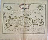 Candia. "Candia olim Creta." Amsterdam Joahannes and Cornelius Blaeu. 1640
Original coloured, copper engraved map of Greece from volume 3 of Joan Blaeu's "Theatrum Orbis Terrarum, sive Atlas novus. Pars Tertia" Double page; folio; Latin text to verso.
General map of Greece showing the peninsular and the Archipelago across to the coast of Asia Minor.
Title cartouche and two blank shields; ships to sea. Original colour; toning and general scattered spotting; tiny wormholes to upper & lower corners of blank margins; lower centre fold split with tape repair to verso.
Zacharakis;386/245;7Koeman1, Bl 36A [275/F] 382 by 528mm (15 by 20¾ inches). €550
The Territory of Cremona.
 Cremonæ Territorium. "Territori di Cremona." Amsterdam Joahannes and Cornelius Blaeu. 1640
Original coloured, copper engraved map of the territory of Cremona from volume 3 of Joan Blaeu's "Theatrum Orbis Terrarum, sive Atlas novus. Pars Tertia" Double page; folio; Latin text to verso.
Decorative title cartouche. Original colour; light even toning with a few spots; drop of wax at to lower corners of blank margins; creasing at centrefold; crease to left half; split at lower centrefold [repaired to verso].
Koeman1, Bl 36B[232(X)] 380 by 502mm (15 by 19¾ inches). €450
Vercelli.
 Dominum Vercellense. "Signora di Vercelli." Amsterdam Joahannes and Cornelius Blaeu. 1640
Original coloured, copper engraved map of Vercelli from volume 3 of Joan Blaeu's "Theatrum Orbis Terrarum, sive Atlas novus. Pars Tertia" Double page; folio; Latin text to verso.
The map has the lakes of Orta and Maggiore at the top with the river po running across the lower half.
Decorative title cartouche and scale. Original colour; creasing to centrefold; 3 small tears to lower margin close to centrefold, repaired on verso; evenly toned; some spots mainly to blank margins.
Koeman1, Bl 36B[224(L)] 420 by 502mm (16½ by 19¾ inches). €450
The Duchy of Milan.
 Ducatus Mediolanensis. "Ducato ouero Territorio di Milano." Amsterdam Joahannes and Cornelius Blaeu. 1640
Original coloured, copper engraved map of the Duchy of Milan from volume 3 of Joan Blaeu's "Theatrum Orbis Terrarum, sive Atlas novus. Pars Tertia" Double page; folio; Latin text to verso.
The map shows the Territory of Milan with Como and Bergamo at the top; Milan to the centre and Pavia below.
Decorative title cartouche; coat of arms. Original colour; slight crease at centre fold; lightly toned mainly to blank margins with a couple of spots.
Koeman1, Bl 36B[228(T)] 385 by 507mm (15¼ by 20 inches). €500
Italy.
 Italia "Nova Italia Delineato." Amsterdam Joahannes and Cornelius Blaeu. 1640
Original coloured, copper engraved map of Italy from volume 3 of Joan Blaeu's "Theatrum Orbis Terrarum, sive Atlas novus. Pars Tertia" Double page; folio; Latin text to verso.
General map of Italy showing the peninsular and the coast of Dalmatia, with Sardinia and Corsica and the north coast of Sicily.
Decorative title cartouche and scale,with ships and monsters to the sea. Original colour; creasing to centrefold split at lower centrefold with repair into image with 2cm of scotch tape, needs restoration.
Koeman1, Bl 36B[103(A)] 390 by 505mm (15¼ by 20 inches). €650
Crimea, Ukraine.
 La Chersonese Taurique. "Taurica Chersonesus Nostra ætate Prezecop et Gazara dicitur" Amsterdam Apud Guiljelmum et Joahannem Blaeu. 1647
Original coloured, copper engraved map of the Crimea and Ukraine from volume 1 of Joan Blaeu's "Le theatre du Monde ou Nouvel Atlas." Double page; folio; French text to verso.
The map after Mercator shows the Crimean Peninsular on the Black Sea with the land now Ukraine and part of Asia minor. Original colour; light toning mainly to margins; spots to blank margins; creases at centrefold and slight loss of surface due to adhesion.
Koeman1, Bl 16A [181(V)] 380 by 500mm (15 by 19¾ inches). €400
Serbia, Bulgaria, Romania & Wallachia.
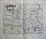 La Servie, Bulgarie,Walachie et Romanie. "Walachia Servia, Bulgaria, Romania " Amsterdam Apud Guiljelmum et Joahannem Blaeu. 1647
Original coloured, copper engraved map of Walachia. Serbia, Bulgaria and Romania from volume 1 of Joan Blaeu's "Le theatre du Monde ou Nouvel Atlas." Double page; folio; French text to verso.
The map after Mercator, shows part of the Ottoman Empire: the countries of the Balkans, including part of the Greek province of Macedonia across to the Albanian coast with part of Moldavia to the north.
Decorative title cartouche surmounted by Ottoman weapons and shield. Original colour; light toning to edges of blank margins; minor spotting to blank margins.
Koeman1, Bl 16A [113(Yy)] 387 by 507mm (15¼ by 20 inches). €400
Sclavonia, Croatia, Bosnia and Dalmatia.
 Le Sclavonie, Croace, Bosne et Dalmace. "Sclavonia, croatia, Bosnia cum Dalmatia Parte. Auct. Ger. Mercatorre.." Amsterdam Apud Guiljelmum et Joahannem Blaeu. 1647
Original coloured, copper engraved map of the Dalmatian coast with Sclavonia Croatia & Bosnia. from volume 1 of Joan Blaeu's "Le theatre du Monde ou Nouvel Atlas." Double page; folio; French text to verso.
The map after Mercator of the countries of the Eastern Balkans.
Decorative title cartouche; three coats of arms of Venice, Hungary and the Ottoman Empire, which all meet in this region. Original colour; light toning to edges of blank margins.
Koeman1, Bl 16A [114(Zz)] 385 by 500mm (15¼ by 19¾ inches). €450
Macedonia Epirus and Achaia, Continental Greece.
 Macadonia, Epirus & Achaia. "Macadonia, Epirus et Achaia." Amsterdam Joahannes and Cornelius Blaeu. 1642
Copper engraved map of Continental Greece from volume 3 of Joan Blaeu's "Novus Atlas" Double page; folio; black & white; German text to verso.
The map shows Continental Greece from Albania to the Corinthian Gulf, naming the regions of Macedonia, Epirus and Achaia amongst others. Macedonia includes the whole plain of Thessally; Mount Athos and Thessalonika in the region of Iamboli; the Ionian Islands and Euboa with the Northern Sporades and Skyros. Decorative title cartouche; scale; ship to sea. Dark impression; clean with very minor spotting to margins.
Zacharakis;387/248; Koeman1, Bl 41A [273/C] 423 by 497mm (16¾ by 19½ inches). €600
Company: Bryan, Mary Louise.
Address: Ag. Andrianoy 92 , 21 100 Nafplio, Greece.
Vat No: EL 119092581