MAPS & VIEWS
PRINTS
BOOKS
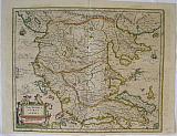
Zurichgow, Switzerland.
 Petrus Kaerius/ Pieter Van der Keere.
"Zurichgow. " Amsterdam, Johannis Cloppenburgji. 1632
Petrus Kaerius/ Pieter Van der Keere.
"Zurichgow. " Amsterdam, Johannis Cloppenburgji. 1632Copper engraved map of Zurichgow, Switzerland, from" Gerardi Mercatoris, Atlas sive Cosmographicae Meditationes de Fabrica mundi et fabricati figura, "Latin text to verso. Dark impression; darker damp stain to upper marginand extreme edge of lower margin.
Keoman:Me200. 190 by 260mm (7½ by 10¼ inches). €50
Natolia,Asia Minor
 Petrus Kaerius/ Pieter Van der Keere.
Natolia, Asia minor Natolia sive Asia Minor. Amsterdam, J Janssonius van Waesberge 1676
Petrus Kaerius/ Pieter Van der Keere.
Natolia, Asia minor Natolia sive Asia Minor. Amsterdam, J Janssonius van Waesberge 1676Copper engraved map of Natolia from. Janssonius Van Waesberge's edition of Gerard Mercator's Atlas after the Clopenberg edition. Original outline colour; verso blank. Under passepartout.
The map published by Joannes Janssonius van Waesberg is a new rendering of the Clopenberg edition of Mercator's Atlas Minor
published in 1673 & 76 under the title Nieuwe en beknopte uytbeeldinghe en Vertooninge der gantscher Aerdbodem in Amsterdam. The son-in-law of Janssonius , he inherited the business and the plates of his father in law. and would continue the publishing passing it his own sons. Good impression. bright original outline colour, evenly toned; light dampstain to upper right corner; old ink number to upper margin. Under passepartout.
Keoman:Me206. Zacharakis 2270/1493 186 by 252mm (7¼ by 10 inches). €200
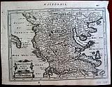
Macedonia, Epirus and Achaia.
 Macadonien, Epirus und Achaia. "Macedonia, Epirus and Achaia." Amsterdam Janssonius, Jan 1649
Copper engraved map of Macedonia, Epirus & Achaia by Mercator, published by Janssonius in his "Novus Atlas, Das ist: Welt-Beschreibung... " Vol 3. Original old colour; German text to verso.
The map first appears in the second part of Mercator's Atlas in 1589 [Me11].
Decorative title cartouche surrounded by putti; ships to sea. Good dark impression; toned as so often with Janssonius maps, with some show through of text from verso; splits at upper and lower centre fold [ each approx 60-70mm repaired with tape to verso]; margins trimmed, as can be seen on the verso just touching some words.
Zacharakis:2213/1453; Koeman II: Me.136 A/ Nnn, map71]. 360 by 435mm (14¼ by 17¼ inches). €650
Crete, and Islands.
 Petrus Kaerius/Pieter van der Keere. / Abraham Goos.
"Candia. " "Crete, ou Candie, Corfu, Zante &c. " Amsterdam, Joannis Janssonii. 1628
Petrus Kaerius/Pieter van der Keere. / Abraham Goos.
"Candia. " "Crete, ou Candie, Corfu, Zante &c. " Amsterdam, Joannis Janssonii. 1628Copper engraved map of the island of Crete, with 6 small maps of Greek islands above, namely: Corfu/Kerkyra, Zante/ Zakinthos, Milo, Nicsia/Naxos. Santorini/Thira and Scarpanto/Karpathos. from the "Atlas Minor" of Gerhard Mercator. French text to verso. Dark impression; very small worm hole to lower, blank margin, evidence of a crack in the plate to right scale of Crete.
Koeman: Me195; Zacharakis:2242/1472. 143 by 199mm (5¾ by 7¾ inches). ` €250
Macedonia, Epirus & Achaia, Greece.
 Petrus Kaerius/Pieter van der Keere. / Abraham Goos.
"Macedonia, Epirus et Achaia. " Amsterdam, Joannis Janssonii. 1628
Petrus Kaerius/Pieter van der Keere. / Abraham Goos.
"Macedonia, Epirus et Achaia. " Amsterdam, Joannis Janssonii. 1628Copper engraved map of Continental Greece from the "Atlas Minor" of Gerhard Mercator. French text to verso. Dark impression; worm hole to lower, blank margin; printed slightly crooked on page hence lower margin6-11mm and right margin4-7mm; small loss of paper to upper right margin.
Koeman: Me195; Zacharakis:2240/1470. €150
Portugal.
 Petrus Kaerius/Pieter van der Keere. / Abraham Goos.
"Portugallia et Algarve. " Amsterdam, Joannis Janssonii. 1630
Petrus Kaerius/Pieter van der Keere. / Abraham Goos.
"Portugallia et Algarve. " Amsterdam, Joannis Janssonii. 1630Copper engraved map of Portugal and the Algarve. from the "Atlas Minor" of Gerhard Mercator. Dutch text to verso Dark impression; rust spot within the plate; slight show through of text from verso.
Koeman: Me197. 140 by 260mm (5½ by 10¼ inches). €120
View of the City of Copenhagen.
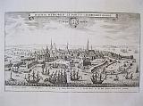 Copenhagen "Hafnia Metropolis et Portus Celeberrimus Daniæ._ Coppenhagen" Frankfurt MW Hoffman for Matthäusr Merian 1642-59
Copper engraved view of Copenhagen from Matthaus Merian's edition of Johann Ludwig, Gottfried's, "Historische Chronica oder Beshreibung der funerstein Geschten so sich von Abfang der Welt..". Black & white; verso blank.
The view shows the city from the sea. with many ships to the foreground. Key below of important buildings. Good impression; folded.
213 by 336mm (8½ by 13¼ inches). €350
Europe.
 Europe. "Europa Nova Delineatio" Frankfurt MW Hoffman for Matthäusr Merian 1642-59
Copper engraved map of Europe from Matthaus Merian's edition of Johann Ludwig, Gottfried's, "Historische Chronica oder Beshreibung der funerstein Geschten so sich von Abfang der Welt..". Black & white; verso blank.
Map of the continent of Europe decorated with ships and monsters to the Atlantic Good impression; folded; rust spot in the sea above Madiera islaands.
290 by 363mm (11½ by 14¼ inches). €400
View of the City of Lyon.
 Lyon "Lyon" Frankfurt MW Hoffman for Matthäusr Merian 1642-59
Copper engraved view of Lyon from Matthaus Merian's edition of Johann Ludwig, Gottfried's, "Historische Chronica oder Beshreibung der funerstein Geschten so sich von Abfang der Welt.". Black & white; verso blank.
The plate also appears in "Topographia Gallia " published by Casper Merian 1655.
The view from above the city shows the position of Lyon between the rivers Rhône and Saône the "Presqu'île" as the peninsular is known. Good impression ; even light toning; smudges to extreme lower blank margin.
242 by 350mm (9½ by 13¾ inches). €200
Decorative Engraved Title of Moll's Classical Atlas.
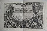 "Geographia Classica, Thirty two new and accurate maps of the geography of the ancients as contained in the Greek and Latin classicks." "Geographia Classica. emmendata ex Græcorum Latinorumq, Authoribus Antiquis, ubi Tabellis XXXII. Veterum Locorum Apellationes Geographiæ recentissimæ et Accuratissimæ summa cum diligentia Accommandantur; Doctissimo Viro WILHELMO STUKELEY M.D. Collegii Medicorum Londinensium et Societatus Regiæ ibidem Socio Humillime oblata ab" London Moll, Herman; Bowles, Thomas & John. c1726
Copper engraved decorative title page for Herman Moll's "Geographia Classica".Black & white; verso blank.
The decorative engraved frontispiece includes illustrations of the Collossos of Rhodes and Biblical and Roman history in the background with four Classical figures in the foreground, the females within a library and the Greek Philosophers on a grassy bank. Black and white; evenly toned; folded.
155 by 228mm (6 by 9 inches). €150
The Abduction of Oreithyia.
 The Abduction of Oreithyia by Boreas. "L'Enlèvement d'Orythie par Borée." Paris "chez l'Auteur, rue de Cloitre St. Benoit No 8.." c.1770
Large copper engraved depiction of the abduction of Oreithyia by Jean Michel Moreau, la Jeune. Black and white, verso blank.
One of a suite of 2 prints by the prolific engraver Moreau le Jeune, (the other depicting Pygmaleon.} The image shows the winged Borreas carrying Oreithyia in his arms, into the clouds with Eros looking on. Surrounded by an engraved border.
OREITHYIA was was a mountain Nymph, daughter of Erechtheus and Praxithea, abducted by boreas, the north wind, WHEN SHE STRAYED beyond the river ilissus, NEAR aTHENS. HE CARRIED HER BACK TO Mount Haemus in ThraCe WHERE SHE BECAME HIS IMMORTAL WIFE AND GODDESS OF CHILL MOUNTAIN WINDS. ONE OF THEIR DAUGHTERS WAS kHIONE (SNOW).
Pausanias, Description of Greece 3. 15. 2 :
"While Orithyia was playing by the ILissos river, Boreas carried her off and had intercourse with her; and she bore daughters, Kleopatra and Khione, and winged sons, Zetes and Kalais." Dark impression; clean and bright.
Bocher;p79; no 205 575 by 420mm (22¾ by 16½ inches). €850
Macedonia, Birthplace of Alexander the Great.
 Macedonia. "Macedonia Alexandri Magni Patria." Amsterdam Petrum Mortier 1705
Copper engraved map of Macedonia by Pierre Mortier from his "Atlas Antiquus" edited by Joannes Clericus. Original outline colour; verso blank.
The map shows the kingdom of Macedonia, birth place of Alexander the Great; part of Thesaly and Epirus and an unnamed, strangely shaped Kerkyra. Dark impression: generally clean and bright; age toning to edges .
Zacharakis;2394/1567; KoemanIII:Mor 4;map62. 439 by 555mm (17¼ by 21¾ inches). €650
Lac Leman, Geneva and Savoy. One plate from Pierre Mortier's famous Wall map.
 Le Grand Teatre de la Guerre en Italie partie 3. 3. Partie continent Les Duchés de Savoye, de Genevois, de Chablis, Les Comtes et Morienne, de Tarentais et La Baronie de faussigny, Le Balliage de Gex et la Seigneurie de Geneve Amsterdam. Covens et Mortier c1741
Copper engraved map of Lake Geneva/ Lac Leman and part of Savoy from Covens & Mortier's " Nieuwe Atlas, Inhoudennde vier Gedeeltens der Waereld.. " Original full wash colour; verso blank.
Third sheet of Pierre Mortier's large wall map Le Grand Teatre de la Guerre en Italie (c. 1705) re issued by Covens & Mortier. [van Egmond mentions two copies of this issue by Covens and Mortier.]
The are covered has Lac Leman to the North and the mountains of Savoy to the South. Dark impression; bright full wash colour; printed on heavy paper; light toning; light spot to right blank margin.
Paper extended with extra fold to fit in Atlas.
Koeman III:Mor1; 54. ; van Egmond, Covens & Mortier, p.406-407, #31.2. 652 by 587mm (25¾ by 23 inches). €300
Münster's Ptolomaic projection of Greece,
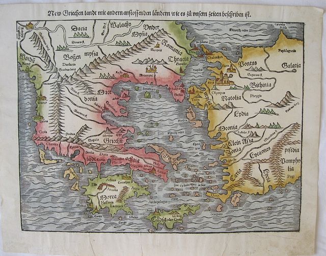 New Griechenland so ieczunt Türctei ist. "New Griechen land mit andern anstossenden Landern wie es zu unsern zeiten beschriben ist" Basle Petri, Heinrich. c1544-72
Woodcut map of Greece after Ptolomaeus from Sebastien Munster's "Cosmographia". Modern hand colour; German title panel on verso is surrounded by an engraved city view [uncoloured].
The map first appeared in the 1540 Basle edition of Ptolomaeus edited by Munster. It is extremely difficult to identify from which edition of the "Cosmographia" the map is taken; Petri published 27 editions with German text.between 1544-1572 . Dark impression; some soiling to blank margins; 2 short tears to lower margin repaired with archival tape to verso.
Zacharakis:2438. 256 by 346mm (10 by 13½ inches). €500
Panorama of Heidleberg.
 " Civitas Heidelbergsis, iuxta Neccarum sita, Palainatus metropolis.."
"Florentissimæ civitatis Heidelbergensis situs & genuina pictura, tam arcem quam reliquaillus loci insigniora ædificia pulchrè intuenti ob oculostatuens." Basileae Henricum Petri 1552.
2 sheet woodcut panorama of Heidelberg from Sebastian Münster's famous "Cosmographia". Black and white; Latin title and text to verso of first plate, second plate with blank verso..
The large panorama on two double pages, un-joined, shows the famous university city from across the river Neckar.
The major buildings are identified in the plate. 2 coats of arms on shields to the sky. 2 double pages, un-joined; good impression;slight show through of title from verso on sheet 1; small hole to upper and lower margins at centre fold of each sheet from binding; light water stain to upper edge of blank margin of sheet 1 and light water stain to lower right corner;short tear to upper blank margin of sheet 2, repaired to verso; light stain to lower left, on river bank, of sheet 2. Guards to verso of each sheet at centre fold .
254 by 720mm when joined(10 by 28¼ inches). €400
Panorama of Worms.
 " Civitas Wormaciencis, olim Vangionum urbs dicta...."
"Vetusttisima Vangionum civits, quam hodie Wormaciam vocant. sita ad rhenum in littore Gallico, expressa hic iuxta formann quam nostro habit ævo." Basileae Henricum Petri 1552.
2 sheet woodcut panaroma of Worms from Sebastian Münster's famous "Cosmographia". Black and white; Latin title and text to verso of first plate, second plate with blank verso..
The large panorama on two double pages, un-joined, shows the city from the banks of the river Rhine.
The major buildings are identified in the plate. Coats of arms on shield held by a dragon to the sky. Monogram of engraver "HSD".
A pre-Roman foundation, Worms was the capital of the kingdom of the Burgundians in the early 5th century and hence the scene of the medieval legends referring to this period, notably the first part of the Nibelungenlied. Worms has been a Roman Catholic bishopric since at least 614, and was an important palatinate of Charlemagne. Worms Cathedral is one of the Imperial Cathedrals and among the finest examples of Romanesque architecture in Germany. Worms prospered in the High Middle Ages as an Imperial Free City. Among more than a hundred Imperial Diets held at Worms, the Diet of 1521 (commonly known as the Diet of Worms) ended with the Edict of Worms in which Martin Luther was declared a heretic. 2 double pages, un-joined; good impression;slight show through of title from verso on sheet 1; small hole to upper and lower margins at centre fold of each sheet from binding; light stain/ toning by church of
S.Johannes; 2 rust marks ro lower corners of sheet 1.Guards to verso of each sheet at centre fold .
254 by 720mm when joined(10 by 28¼ inches). €300
The Ancient World According to Ptolemy.
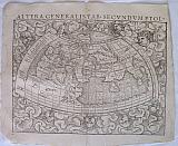 "Altera Generalis Tab.Secunumptol.." " Terreni Orbis Generalis et Ptolemaica descriptio...." Basileae Henricum Petri 1552.
Double page woodcut map of the Ancient World from Sebastian Münster's famous "Cosmographia". Black and white; Latin title to verso.
Map of the ancient World as described by Ptolemy; surrounded by clouds and eleven windheads, with their names in banners. The known continents are oddly shaped and all connected by a great southern continent Terra incognito secundum Protemeum. There is a very large Taprobana (modern day Sri Lanka) in the Indian Ocean and the Indian subcontinent is severely truncated. Only northern Africa is shown, joining the Terra incognitaIt is however defined by two great river systems, the Niger, extending form the Atlantic, and the Nile from its source in a mountain range. Good impression; small hole at top centre fold above title and at lower centre fold in blank margin [ from former binding]; creases to centre fold; edges slightly ragged ; lower left corner torn and right margin slightly shorter at upper corner; damp staining to edges of side margins.
Shirley #76. 253 by 343mm (10 by 13½ inches). €1000
Panorama of Vienna.
 "Anno Domini 1548. Viena Austriæ Hunc Habuait Situm." "Civitas Vienensis, Urbs metropolitana..."
"Vienna Austriæ metropolis, urbs toto orbe notissima celebratissima que. unicum hodie in Oriente contra sæuissimum Turcam invictum propugnaculum & fortalicum, expressa ad nostri æqum habet figuram." Basileae Henricum Petri 1552.
2 sheet woodcut panorama of Vienna from Sebastian Münster's famous "Cosmographia". Black and white; Latin title and text to verso of first plate, second plate with blank verso..
The large panorama on two double pages, un-joined, was engraved by Hans Rudolph Manuel Deutsch and Heinrich Holzmuller.[ both monograms appear in the second sheet, along with the date 1548 ] after a view by Wolfgang Lazius.
The major buildings are identified in the plate. Large decorative banner title to the sky, and coat of arms. 2 double pages, unjoined; good impression; side margins trimmed just entering plate [could be re margined]; small hole to upper and lower margin from binding; light water stain to lower blank margin of sheet 1and short upper centre fold split , repaired to verso; small rust mark to lower centre fold of sheet 2 and vertical crease to right side. Guards to verso of each sheet at centre fold .
224 by 765mm [when joined](8¾ by 30 inches). €1000
Bohemia, Czech Republic.
 "Bohemiæ descriptio iuxta insignores eius civitas & oppida.." " Bohemi Ciregnita tabula...." Basileae Henricum Petri 1552.
Double page woodcut map of Bohemia from Sebastian Münster's famous "Cosmographia". Black and white; Latin title to verso.
The map shows the area of Bohemia , now part of the Czech Republic. small key to lower right corner. Good impression; small hole at top centre fold above title and at lower centre fold in blank margin[ from former binding];crease to lower centre fold; old ink annotations to right blank margin.
255 by 353mm (10 by 14 inches). €150
Constantinople.
 "Constantinoplitanæ urbis effiges, quam hodie sub turcæ inhabitatione habet.." " Civitas Constantinopolitana, olim imperii Orients sicut & hodie turcica monarchiæ,..." Basileae Henricum Petri 1552.
Double page woodcut bird's eye view of Constantinople from Sebastian Münster's famous "Cosmographia". Black and white; Latin title to verso.
Engraved by David Kandel [initials to lower right corner], the view shows the city surrounded by numerous ships, highlighting its importance as a trading hub between Europe and Asia.
Major buildings are named within the plate or in the text below. Good impression; minor show through of text from verso; small hole to upper and lower margin from binding; light damp stain to upper blank corners.
203 by 376mm (8 by 14¾ inches). €1000
Florence.
 "Florentia nobilissima Hethruriæiutas, deformata ad nostra tempora." " Civitas Florentina Hetruscorum metropolis,..." Basileae Henricum Petri 1552.
Double page woodcut view of Florence from Sebastian Münstar's famous "Cosmographia". Black and white; Latin title to verso.
Early woodcut view of the city of Florence, from across the river Arno, looking towards the old city. Good impression; minor show through of text from verso; slight creasing at centre fold , small hole to upper and lower margin from binding.
222 by 358mm (8¾ by 14 inches). €700
Jerusalem.
 "Ierusalem civitas sancta, olim metropolis regni iudaici, hodie vero colonia Turcæ.." " Civitas Ierusale ... Præconia Prophetica civitatis Ierosolymitanæ..." Basileae Henricum Petri 1552.
Double page woodcut bird's eye view of Jerusalem from Sebastian Münster's famous "Cosmographia". Black and white; Latin and Hebrew title and text to verso.
The view engraved by Jakob Clauser, shows the city when it was part of the Ottoman Empire, hence the numerous crescents on the minarets, with Mount Zion in the background.
Major buildings are named within the plate.
Text below describing Jerusalem and also the city of Jericho wityh small vignetteof a plant.
Small woodcut view of Acre by David Kandel to verso set within Latin text Good dark impression;; small hole to upper and lower margin from binding; small stain to lower blank margin..
154 by 374mm (6 by 14¾ inches). €800
Poland and Hungary, Central Europe
 "Polonia et Ungariae Nova Descriptio." " Poloniae Et Ungariae Descriptionem...." Basileae Henricum Petri 1552.
Double page woodcut map of Central Europe, Poland & Hungary from Sebastian Münster's famous "Cosmographia". Black and white; Latin title to verso.
The map shows the area of Central Europe: Poland, White Russia down to the Crimea; Hungary and part of Bosnia and Bulgaria, with the course of the Danube to the Black Sea. Good impression; small hole at top centre fold above title and at lower centre fold in blank margin[ from former binding]; slight creasing at centre fold; minor chips to edges.
255 by 342mm (10 by 13½ inches). €400
Schwaben & Bavaria, Germany
 "Sueviae et bavariae Descriptio." " Suevia et Bavariae Particularum descriptioem..." Basileae Henricum Petri 1552.
Double page woodcut map of Schwaben and Bavaria from Sebastien Münster's famous "Cosmographia". Black and white; Latin title to verso. Good impression; tiny holes from former binding to upper and lower blank margins at centre fold.
256 by 342mm (10 by 13½ inches). €100
The Roman Ampitheatre of Verona
 "Theatrum Veronese: 1549." " Figura theatri Veronensis, quum adhuc integrum & perfectum asset. Hodie ruinæ eius extant." Basileae Henricum Petri 1552.
Double page woodcut view of the ampitheatre at Verona from Sebastien Münster's famous "Cosmographia". Black and white; Latin title to verso.
Early woodcut view of the famous "rose "ampitheatre at Verona drawn by Hans Rudolph Manuel Deutsch. Title in large decorative banner; text below image.
Completed around 30 AD, it is the third largest in Italy after Rome's Colosseum and the arena at Capua. It measures 139 metres long and 110 metres wide, and could seat some 25,000 spectators in its 44 tiers of marble seats. The ludi (shows and gladiator games) performed within its walls were so famous that they attracted spectators from far beyond the city. The current two-story façade is actually the internal support for the tiers; only a fragment of the original outer perimeter wall in white and pink limestone from Valpolicella, with three stories remains.The interior is very impressive and is virtually intact, and has remained in use even today for public events, fairs, theatre and open-aired opera during warm summer nights. Good dark clear impression; minor show through of text from verso; slight spotting to lower margin; small binding hole to centre of upper margin; short centre fold split to lower margin, far from image, repaired to verso..
201 by 361mm (8 by 14¼ inches). €250
Bird's Eye Plan of Amsterdam.
 Amsterdam. Basileae Henricum Petri 1552.
Woodcut half page bird's eye plan of Amsterdam engraved by Heinrich Holzmüller from Sebastian Münster's famous "Cosmographia". Black and white; set above Latin text with text and vignette to verso.
The map is after a woodcut by Cornelis Anthonisz, 1544. The text below however describes Rotterdam and continues to the verso where there is a woodcut vignette of Erasmus after the porrait by Hans Holbein the Younger . Good impression; some pencil underlining to text.
153 by 178mm (6 by 7 inches). .Full page:318x210mm €100
Geneva, Switzerland.
 Civitas Genevësis.. " Clarissiniæ civitatis Genevensis situs & figuratio, latusque eius meridianum.." Basileae Henricum Petri 1552.
Double page woodcut view of Geneva from Sebastian Münster's famous "Cosmographia". Black and white; Latin title to verso.
The woodcut view shows the city from across Lake Geneva/ Lac Léman with the covered bridge joining the two parts of the city.
Coat of arms to upper left corner ; text below. Good dark impression; minor show through of text from verso; small hole to upper and lower margin from binding; light spotting to centre of view & light damp stain to lower blank margin, below text; lower centre fold split, repaired to verso; old ink under linings and corrections to text.
154 by 355mm (6 by 14 inches). €200
Egypt and the Nile.
 Egypt Basileae Henricum Petri 1552.
Half page woodcut map of Egypt and the Nile delta from Sebastian Münster's famous "Cosmographia". Black and white; set above Latin text with text and vignettes to verso.
The map shows the delta of the Nile, with Cairo and the Pyramids of Giza marked, oddly the pyramids are designated by blocks rather than pyramids. The vignettes to verso show farming and Hercules. Good impression; long tear from bottom edge through text just entering image by 15mm through " Mare Aegyptiu"to keel of ship [Repaired to verso with archival tape].
174 by 160mm (6¾ by 6¼ inches).Full page:318x210mm. €50
Tyre, Lebanon.
 Tyre. "Tyrus" Basileae Henricum Petri 1552.
Woodcut vignette view of Tyre, Lebanon from Sebastien Münster's famous "Cosmographia". Black and white; set above Latin text with text to verso.
The stylised vignette view shows the towers of the city in the midground with numerous ships to the sea in the foreground and horizon.
Tyre originally consisted of two distinct urban centers, Tyre itself, which was on an island just off shore, and the associated settlement of Ushu on the adjacent mainland. Alexander the Great connected the island to the mainland by constructing a causeway during his siege of the city.
The original island city had two harbours, one on the south side and the other on the north side of the island. It was these two harbours that enabled Tyre to gain the maritime prominence that it did; the harbour on the north side of the island was, in fact, one of the best harbours on the eastern end of the Mediterranean. Good impression.
105 by 112mm (4¼ by 4½ inches). Full page:318x210mm. €50
The Island of Crete.
 Crete. "Candia" Wien, Nurnberg, Peter Conrad Monath. 1735
Copper engraved map of Crete from Angelicus Maria Myller's "Peregrinus in Jerusalem..". Modern hand colour; verso blank.
The map shows the island with the city of Iraklion- Candia dominating the north coast; with the mythical Labarynth marked in the centre of the island; the nearby small islands are shown; galleons decorate the sea. Good impression; modern habd colour; mounted.
Zacharakis /1594 152 by 190mm (6 by 7½ inches). €450
Company: Bryan, Mary Louise.
Address: Ag. Andrianoy 92 , 21 100 Nafplio, Greece.
Vat No: EL 119092581