MAPS & VIEWS
PRINTS
BOOKS
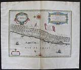
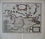
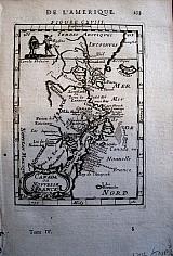
Miniature Map of Peru.
 Petrus Kaerius/Pieter van der Keere; Jodicus Hondius.
"Descriptio Peruviæ" Peru. Amsterdam Jodicus Hondius Jr. 1616
Petrus Kaerius/Pieter van der Keere; Jodicus Hondius.
"Descriptio Peruviæ" Peru. Amsterdam Jodicus Hondius Jr. 1616Copper engraved map of Peru from Petrus Bertius' "Tabularum geographicum contractarum libri septum. " Latin text to verso describing the succeeding map. Dark impression.
Koeman: Lan 11. 100 by 135mm (4 by 5¼ inches). €120
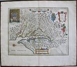
Chile.
 Chili. "Chili." Amsterdam Apud Johannem Guiljelmi F. Blaeu. c1655
Original coloured, copper engraved map of Chile from volume 2 of Joan Blaeu's "Theatrum Orbis terrarum, sive atlas novus .pars secunda." Double page; folio; Latin text to verso.
Large strap work cartouches for title and scale, banner with key small cartouche for author, ships and compass roses to sea. Bright original outline colour; good impression; Printers creases at centre fold; damp stain to edges of blank margins, far from image.
Koeman1, Bl 24C. 357 by 476mm (14 by 18¾ inches). €400
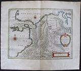
Paraguay, South America.
 Descriptio Paraguay sive Provinciæ Rio de La Plata, cum regionibus adjacentibus Tucuman et Santa Cruz de la Sierrra. "Paraguay, o Prov. de Rio de la Plata cum regionibus adiacentibus Tucuman et Sta Cruz de la Sierra." Amsterdam Apud Johannem Guiljelmi F. Blaeu. c1655
Original coloured, copper engraved map of Paraguay from volume 2 of Joan Blaeu's "Theatrum Orbis terrarum, sive atlas novus .pars secunda." Double page; folio; Latin text to verso.
Strap work title catouche; large compass rose.
The map shows the Northern Patagonia territory. Also showing Rio de Janeiro, Sao Paolo, Santa Cruz of Bolivia, Paraguays, Uruguay, Buenos Ayres, Chili and Santo Iago. Bright original outline colour; good impression; damp stain to edges of blank margins, far from image.
Koeman1, Bl 24C. 375 by 478mm (14¾ by 18¾ inches). €350
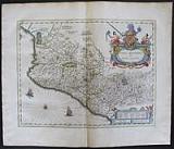
The Isthmus of Panama, Costa Rica and Columbia.
 Descriptio Terræ Firmæ, Novi regni Granatensis, et Popayan. "Terra firma et Novum Regnum Granatensis et Popayan." Amsterdam Apud Johannem Guiljelmi F. Blaeu. c1655
Original coloured, copper engraved map of Panama And Columbia from volume 2 of Joan Blaeu's "Theatrum Orbis terrarum, sive atlas novus .pars secunda." Double page; folio; Latin text to verso.
Strap work title catouche and scale; compass roses to sea.
Decorative map of the Isthmus of Panama and North Western South America including most of present day Columbia and part of Venezuela.
Terra Firma is Panama, Veraguas is Costa Rica, and Popayan in the west and Nuevo Rey Node Granada in the east refers to the mountainous Columbia.
The map is significant both for illustrating these early historic areas in the New World and for the numerous settlements, rivers and mountains.
The map is based on the cartography of Hessel Gerritsz. Bright original outline colour; good impression; light damp stain to edges of blank margins, far from image.
Koeman1, Bl 24C. 378 by 490mm (15 by 19¼ inches). €500
Virginia & Florida.
 Florida. "Virginiæ partis australis et Floridæ partis orientalis, interjacentiumq, regionum Nove Descriptio." Amsterdam Apud Johannem Guiljelmi F. Blaeu. c1655
Original coloured, copper engraved map of Virginia & Florida from volume 2 of Joan Blaeu's "Theatrum Orbis terrarum, sive atlas novus .pars secunda." Double page; folio; Latin text to verso.
Large decorative title catouche ; scale with 2 putti, of which the left has a tail thus 2nd state; ships and compass roses to sea.
Cartographically this map forms a marked improvement on the Jodocus Hondius map of 1606, from which this was largely derived. It also amply illustrates the direction that engraving styles had moved, being more open and florid. The map depicts two nations' interests, both marked by their own coat of arms. The French claim, being largely present day Georgia, rests on the abortive colonial attempts of the 1560s. Blaeu makes no advance here in geography, following Hondius to the letter.
The greatest improvement occurs in the northern half of the map north of Porto Royal. Whereas on the Hondius the coastline towards C. de Ste. Romano (present day Cape Fear) veered directly east, Blaeu more correctly takes it north-east, placing the cape closer to its true position of 34°. This span of coastline is approximately that of present day South Carolina's. This now present to us a more accurately proportioned Outer Banks Region, radically reduced in size but still slightly too far north. For these improvements Blaeu drew upon the extremeley rare DE EYLANDEN ..., by Hessel Gerritsz, c. 1631. The Outer Banks combine the placenames of Gerritsz and Hondius, often using two different ones for the same area such as C. de Trafalgar and C. ost Feare. This latter name was often applied to present day Cape Lookout before it was used for its present site to the south-west.
Chesapeake Bay was depicted as just a small bay on Hondius' map of 1606 as John Smith was yet to explore these waters. The Gerritsz terminated at this point, and only two placenames appeared. Blaeu draws largely on the Smith map for much of the nomenclature but introduces some English ones from an unknown source. The most important is Newport nesa, Newport News, founded in 1621 and apparently shown here for the first time on a printed map. Also new are Bermouth, Stortingen and Arglas. The two Indian figures from Hondius' map form part of the cartouche on Blaeu's. The winged cherub to the left of the scale provides the only difference to the two known states. [Burden: The Mapping of America]
Bright original outline colour; good impression; light damp stain to edges of blank margins, far from image.
Koeman1, Bl 24C.; Burden: 253 State 2. 386 by 506mm (15¼ by 20 inches). €1500
The Straits of Magellan, Tierra de Fuego. and Le Maire Strait.
 Fretum Magallanicum. Fretum Le Maire. "Tabula Magellanica, quâ Tierræ del fuego, cum celeberrimis fretis F. Magellano at I. Le Maire detectis novissima et acuratissima descriptio exhibetur." Amsterdam Apud Johannem Guiljelmi F. Blaeu. c1655
Original coloured, copper engraved map of Magellanica from volume 2 of Joan Blaeu's "Theatrum Orbis terrarum, sive atlas novus .pars secunda." Double page; folio; Latin text to verso.
3 strap work catouches for title, scale and key; coat of arms and dedication to Constantino Hugenio (Constantijn Huygens, the secretary of the two Princes of Orange, Frederick Henry and William II);; fleet of ships and compass roses to sea.
Ferdinand Magellan discovered and explored the sea route between the mainland of South America and Tierra del Fuego during his circumnavigation of the globe. The natural passage between the Atlantic and the Pacific Ocean is named today Strait of Magellan. Magellan himself died during this journey on 27 April 1521 in the Philippines.
The map bears Willem Blaeu's signature but was published by his son Joan.
The map shows the results of the expeditions of Willem Cornelisz Schouten and Jacob Le Maire (1615-1617), who discovered Cape Horn, and those of the Nassau fleet under admiral Jacques l'Heremite and vice-admiral Gheen Huygen Schapenham (1623-1626). "Lheremitens eylandt" and "Schapenhams bay" are named after these two expedition leaders. Bright original outline colour; good impression; fairly extensive damp stain to edges of blank margins, just touching image.
Koeman1, Bl 24C. 375 by 478mm (14¾ by 18¾ inches). €600
Guiana, South America.
 Guiana sive regio Amazonum. "Guiana sive Amazonum Regio." Amsterdam Apud Johannem Guiljelmi F. Blaeu. c1655
Original coloured, copper engraved map of Guiana from volume 2 of Joan Blaeu's "Theatrum Orbis terrarum, sive atlas novus .pars secunda." Double page; folio; Latin text to verso.
Strap work title catouche and scale; compass rose and ships to sea.
Decorative map of the Guianas , Lake Parima (Parime Lacus), and the route to El Dorado.Initially issued in 1630 , variants were published well in to the 1660s. The map covers from Isla Margarita and the Orinoco Delta eastward as far as Tampico and southwards as far as the Amazon River.
This region of South America generated considerable European interest in the early 17th century following the publication of Sir Walter Raleigh's fascinating 'Discovery of the Large, Rich, and Beautiful EMPIRE Of GUIANA .' Raleigh's expedition traveled down the Orinoco River in search of the Kingdom of El Dorado. Today we know that El Dorado did not exist, but was rather an amalgam of very real tribal traditions and the European lust for gold. Nonetheless, in the 16th century, tales of El Dorado were common conversation along the port cities of the Spanish Main. Having explored a considerable distance down the Orinoco, Raleigh's expedition found itself mired in a remote tribal village at the onset of the rainy season. While waiting for an opportunity to return north, a trading delegation arrived. At this time the dominate trading empire in the Amazon were the Manoa, who, though based near modern day Manaus, pursued trade routes to from the foothills of the Andes to the Amazon and Orinoco Deltas. While the rainy season prevented Raleigh from moving forward, for the Manoa it had the opposite effect. The heavy rains inundated the vast Parima flood plain creating a great inland sea, consequently opening an important trade connection between the Amazon and Orinoco Rivers. When the Manoa arrived, Raleigh and his men noticed that they had various golden trinkets for sale. This was apparently enough for Raleigh to deduce that they must indeed be from the hidden kingdom of El Dorado. When Raleigh asked where the traders came from, the locals, with no common language with which to engage Raleigh, could only explain that they traveled across a great water and were from Manoa. Raleigh's presumptuous narrative inspired many early cartographers to map this massive lake, with the city of El Dorado or Manoa on its shores, in the unexplored lands between the Orinoco and Amazon River basins. Bright original outline colour; good impression; damp stain to edges of blank margins, far from image.
Koeman1, Bl 24C. 376 by 494mm (14¾ by 19½ inches). €400
The Carribbean.
 Insulæ Americanæ, in Oceano Septemtrionali, Ante sinum Mexicanum, & aliquot Continentis regiones. "Insulæ Americanæ, in Oceano Septemtrionali cum Terris adiacentibus." Amsterdam Apud Johannem Guiljelmi F. Blaeu. c1655
Original coloured, copper engraved map of the Caribbean from volume 2 of Joan Blaeu's "Theatrum Orbis terrarum, sive atlas novus .pars secunda." Double page; folio; Latin text to verso.
Large strap work title cartouche and scale: dedication cartouche surmounted by coat of arms; ships and compass roses to sea.
Blaeu's chart of the Caribbean, based on a section of Blaeu's own West Indische Paskaert (ca. 1630) and Hessel Gerritsz' rare chart of 1631. The chart was the most accurate for its time and was used throughout the seventeenth century.
The chart covers practically the same area as the Gerritsz chart, but adds the west coast of Central America and the South Sea ( Mare del Zur). Although this western coast is shown on the chart, there are no place names there. Every other coast is detailed in its toponyms, reflecting the advanced nature of European colonialism in the mid-seventeenth century. The place names in Florida and what is now the US Gulf Coast are mostly Spanish in origin, suggesting the use of a hard-to-get Spanish chart for that section.
The place names along the coast of eastern North America are practically identical to the Gerritsz chart, other than the important addition of Virginia here. According to Burden, Blaeu also accurately shows the distance between Chesapeake Bay and Albemarle Sound to be only 1°, whereas many contemporaries show them a further distance from each other.
The coastlines are colored decoratively, not to reflect political boundaries. The map is embellished with several other aesthetic details that make it distinctive to other charts of the area based on Gerritsz. A delicate scrolling script and rhumb lines fill the seas, as do five ships in full sail. The ships underline the region's importance to Europeans; it was a major center for trade, resources, and a site for forced labor. Bright original outline colour; good impression; light damp stain and toning to edges of blank margins.
Koeman1, Bl 24C. 383 by 526mm (15 by 20¾ inches). €1300
Mexico, Novea hispania.
 Nova Hispania. "Nova Hispania et Nova Galicia." Amsterdam Apud Johannem Guiljelmi F. Blaeu. c1655
Original coloured, copper engraved map of Mexico from volume 2 of Joan Blaeu's "Theatrum Orbis terrarum, sive atlas novus .pars secunda." Double page; folio; Latin text to verso.
Large decorative title catouche ; ships and compass rose to sea.
Map of Mexico extending from just north of Mazatlan to Acapulco and from Tehuacan to the Sierra Madres, showing Mexico City, Puebla (Angelorum Civitas), Colima, Campostella, Purificatio and Mechoacan as the major cities of the time.
Based on Ortelius's map of 1579 which became the basis for many of the seventeenth century maps of the area.
Despite the implications in the title, the map does not cover all of the provinces of New Spain, only a portion of modern Mexico. At the time, the region was described as being rich in gold & silver, with pearl-fishing carried on in the coastal regions. The numerous salt lakes produced the finest salt by means of evaporation, and much was made of the sugar-cane cultivated here.
In the east of the mapped area, below the large title cartouche may be seen the area of Mexico city, situated on the shores of a large lake, described as an ample city, queen of all the cities in the New World. Although the mapmaker gave no clues, the small lozenge shaped symbols to the left of the cartouche probably indicate gold or silver mines.
The elaborate title cartouche is surrounded by the Spanish Royal Coat of arms. Bright original outline colour; good impression; light damp stain to edges of blank margins, far from image.
Koeman1, Bl 24C. 385 by 502mm (15¼ by 19¾ inches). €500
After John Smith's famous map of Virginia.
 Virginia. "Nova Virginiæ Tabula." Amsterdam Apud Johannem Guiljelmi F. Blaeu. c1655
Original coloured, copper engraved map of Virginia from volume 2 of Joan Blaeu's "Theatrum Orbis terrarum, sive atlas novus .pars secunda." Double page; folio; Latin text to verso.
Oriented West, based upon John Smith's landmark map of the Virginia colony issued in 1612 the plate is drawn from Jodocus Hondius' plate of 1618 . Blaeu acquired a number of Hondius ' plates in 1629 thus it is the 2nd state with the imprint of Blaeu, which would appear in Blaeu's atlases from 1630 to 1663.
Taken from the first state of the Smith, it continues the coastlines where the former had left them vague. It features a Sasquesahanough Indian in the top right and the arms of James I of England and VI of Scotland appearing next to the cartouche with the explanation of the symbols; in the upper left a vignette of the famous scene of Powhatan, Pocahontas and John Smith.
one of the most important maps of America ever produced and certainly one of the greatest influence. [Philip D. Burden,The Mapping of America.] Bright original outline colour; good impression; damp stain to edges of blank margins, far from image.
Koeman1, Bl 24C.; Burden, 193. 2nd state. 377 by 482mm (14¾ by 19 inches). €2200
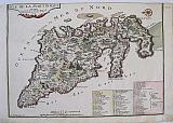
Brazil
 "Die Landstschafft Brasilien" "Brasilia..." Amsterdam: Johannem Blaeu. 1647
Copper engraved map of Brazil from Johannes Blaeu's " Nouvus Atlas Das ist Welt-berschreibung.."Vol 2 . Coloured; German text to verso.
Oriented with west at the top this is Blaeu's second map of Brazil; many details around the coast, whilst the interior is mainly empty with a few conjectural features.
Decorative title cartouche and scale in each corner; compass roses and ships to sea . Generally a good impression with, probably, later hand colour; short split to lower centre fold [approx 7mm] repaired with archival tape to verso; a couple of spots to blank margins.
Koeman:Bl 34: O [12]. 386 by 492mm (15¼ by 19¼ inches). €800
Venezuela, South America.
 Venezuela. "Venezuela cum parte Australi Novæ Andalusiæ.." Amsterdam: Johannes and Cornelius Blaeu. 1640 [but 1643-1645].
Copper engraved map of Venezuela from the 2nd edition of Blaeu's " Le Theatre du Monde ou Nouvel Atlas"Vol 2 .'This edition ... is a much more advanced one than the edition of 1638/1640. The text has been reset' (Van der Krogt) Original outline colour; French text to verso.
The map also shows the Windward Islands; the Leeward Antilles : Aruba ,Bonaire & Curaçao; and Trinidad & Tobago; compass rose and two sailing ships in the Pacific Ocean, animals to interior of country. Bright and clean; light toning to edges of blank margins.
Van der Krogt II, p.150 and 2:212.2 ;Koeman:Bl 17: O [52]. 380 by 490mm (15 by 19¼ inches). €500
Cusco, Peru.
 Frans Hogenberg & Simon Novellanus`
Cusco, Peru. " Cusco, Regni Peru In Novo Orbe Caiut. ". Cologne Theodori Graminæi. 1572
Frans Hogenberg & Simon Novellanus`
Cusco, Peru. " Cusco, Regni Peru In Novo Orbe Caiut. ". Cologne Theodori Graminæi. 1572Copper engraved view of the Inca capital Cusco. Peru from the first volume of Braun & Hogenberg's "Civitas Orbis Terrarum. " Original full colour; verso blank
The view shows the city of Cusco, the palace and temple, with a procession in the foreground of an Inca King, possibly Atahualpa, being carried aloft on a covered throne by his subjects. Good impression; toned with some damp staining and soiling to blank margins; side margins trimmed to platemark, as it has been divided from the view of Mexico city on one side.
KeomanII; B&H1/58 273 by 237mm (10¾ by 9¼ inches). €500
Mexico City.
 Frans Hogenberg & Simon Novellanus`
Tennochtitlan, Mexico City. "Mexico, Regia et celebris Hispaniæ Novae Civitas. " Cologne Theodori Graminæi. 1572
Frans Hogenberg & Simon Novellanus`
Tennochtitlan, Mexico City. "Mexico, Regia et celebris Hispaniæ Novae Civitas. " Cologne Theodori Graminæi. 1572Copper engraved view of the Aztec capital of the New World: Tenochtitlan, Mexico City,f rom the first volume of Braun & Hogenberg's "Civitas Orbis Terrarum. " blank verso.
The view of Mexico city, or Tenetchtitlan is taken from a map in the letters of Hernan Cortes published in 1525. Good impression; evenly toned; remargined on right marginas it is half of the page .
Keoman vol2; B&H1/58 273 by 230mm (10¾ by 9 inches). €600
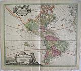
The Americas.
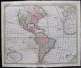 America Accurate in Imperia, Regna, Staus & Populos Divisia, ad Usum Ludovici XV Galliarum Regis. Carte d'Amerique.
Amsterdam. Covens et Mortier c1741
Copper engraved map of of the Americas from Covens & Mortier's " Nieuwe Atlas, Inhoudennde vier Gedeeltens der Waereld.. " Original full wash colour; verso blank.
Black and white strap work title cartouche [as issued]."Avertisement" on black & white drape to lower right corner
The map after Guillaume De l'Isle's shows the whole continent, with part of Europe and Africa to the East. The map includes a Prime Meridian declared by Louis XIII and Pope Alexander VI's Line of Demarcation that divided the world (outside of Europe) between Portugal and Spain. Includes detailed information about discoveries and explorations particularly around the Magellan strait and the discovery of the Falkland islands in 1706. Dark impression; bright full wash colour; printed on heavy paper, short centre fold split at lower margin with old repair to verso and lower margin; old red crayon numbers to verso.
Koeman I: C&M 8:103. 510 by 615mm (20 by 24¼ inches). €1200
Saint Domingo, Hispaniola.
 Insulæ S, Dominicæ Tabula Accuraetissima. Carte de l'Isle de Saint Domingue Dressee en 1722 pour l'usage du Roy sur les memoires de Mr. Frezier Ingenieur de S.M. et autres assujettis aux Observations Astronomiques ..
Amsterdam. Covens et Mortier Dated 1722 to cartouche but c1741
Copper engraved map or chart of of the island of Hispaniola showing St. Domingo from Covens & Mortier's " Nieuwe Atlas, Inhoudennde vier Gedeeltens der Waereld.. " Original full wash colour; verso blank.
Black and white strap work title cartouche [as issued].
The map after Guillaume De l'Isle shows the whole island in detail; the Western half [ now Haiti was ] taken by the French in 1659, whilst the Eastern half remained Hispaniola under the control of the Spanish, [ now the Dominican Republic].
Saint-Domingue was a French colony on the Caribbean island of Hispaniola from 1659 to 1804. The French mainly Buccaneers had established themselves on the western portion of the islands of Hispaniola and Tortuga by 1659. In the Treaty of Ryswick of 1697, Spain formally recognized French control of Tortuga island and the western third of the island of Hispaniola.
The map also shows the Eastern tip of Cuba and the nearby islands; with borders indicated between. 2 compass roses and rhumb lines have been added making it more of a sea chart. Dark impression; bright full wash colour; printed on heavy paper; old red crayon numbers to verso.
Koeman I: C&M 8:116. 515 by 627mm (20¼ by 24¾ inches). €600
Martinique.
 Martinique. Carte de l'Isle de la Martinique Colonie Françoise de l'une des Isles Antilles de l'Amerique..
Amsterdam. Covens et Mortier c1741
Copper engraved map or chart of of the island of Martinique from Covens & Mortier's " Nieuwe Atlas, Inhoudennde vier Gedeeltens der Waereld.. " Original full wash colour; verso blank.
Black and white strap work descritive key cartouche [as issued].
The map after Guillaume De l'Isle and Phillippe BUACHE shows the island divided into 3 areas, by different colours , representing the 3 different religious orders: the Dominicans to the North [ yellow] with the port of La Trinité ; the Capuchins to the South East [pink] with the town and Fort of St. Pierre and the Jesuits to the West [green] with Fort Royale. 2 compass roses and rhumb lines . Dark impression; bright full wash colour; printed on heavy paper; light soiling; old red crayon numbers to verso.
Koeman I: C&M 8:118. 480 by 600mm (19 by 23½ inches). €500
Mexico and Florida, the English Territories and the Islands of the Carribean.
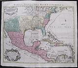 Tabula Geographica Mexicæ et Floridæ &c. Carte du Mexique et de la Floride des Teres Angloises et des Antilles. du Cours et des Environs de la Riviere de Mississsipi.
Amsterdam. Covens et Mortier Dated 1722 in cartouche
Copper engraved map of Canada from Covens & Mortier's " Nieuwe Atlas, Inhoudennde vier Gedeeltens der Waereld.. " Original full wash colour; verso blank.
Black and white strap work title cartouche and mile scale [as issued].
The map after Guillaume De l'Isle actually engraved by his father, Claude, also a cartographer.was first published in 1703 and is the first printed map to accurately depict the course, mouth and delta of the Mississippi River.
The Missouri River is also shown. Includes many sea routes across the Gulf of Mexico and between the islands.
De L'Isle drew the map from the reports brought back to France from the survivor's of the La Salle expedition into the interior of North America.
In 1682, René-Robert Cavelier, Sieur de La Salle was the first European to travel from the Great Lakes down the Mississippi River to the Gulf of Mexico.
Pierre Le Moyne d'Iberville would travel up the Mississippi to Biloxi in 1699 & 1700, On his third voyage in February 1701, he built a fort at Mobile. He left Louisiana for the last time in April 1702. His brother Jean-Baptiste Le Moyne de Bienville founded New Orleans in 1718.
De L'Isle's map also includes greater accuracy in the Great Lakes region and in its depiction of English settlements along the East Coast.
One of the most important and influential maps of the region during the early 18th Century. Dark impression; bright full wash colour; printed on heavy paper; light soiling.old red crayon numbers to verso.
Koeman I: C&M 8:114. 485 by 602mm (19 by 23¾ inches). €1500
Martinique.
 The Island of Martinique. "Isle de la Martinique." Paris de Fer, Nicolas 1704
Copper engraved map of Martinique from Nicolas de Fer's "Alas Curieux", Original colour; verso blank.
Detailed map engraved by P Starckman, with long key identifying 63 places of interest Dark impression; upper margin trimmed to plate mark; crease to lower right corner;ink number to upper right corner.
261 by 364mm (10¼ by 14¼ inches). €280
The Americas.
 America "Totius Americae Septrionalis et Meridionalis Novissima Representatio quam ex singulis Geographorum Tabulis collecta luci publicae accommodavit .." Nuremberg Homann, Johann Baptist c1720
Copper engraved map of the continent of America by Johann Bapt. Homann from his "Grosser Atlas" . Original colour, verso blank.
Decorative title cartouche and vignette showing native Americans and the fauna and flora of the country,with another cartouche surrounding description of discoveries, black and white as issued. The title cartouche is based upon De Fer's landmark map of 1699. The top cartouche is based upon De L'Isle's 1703 map of Canada. The map is a revision of the elder Homann's 1710 map of the Americas. After his death in 1724, his son (Johann Christoph Homann) re-engraved the plate to correct the western coastline of North America, shown here extending very far west and north, with very little detail. California is no longer shown as an island, although the remnants of the interior sea can be seen near the Pais de Moozemleck, and a hint of a hoped for Northwest Passage is beginning to take shape. The Great Lakes are taking shape, being actively explored by the French fur traders and Hudson Bay Company. Good impression; old rust marks to upper margin (from a paperclip) just entering scale; small hole to left of these in blank margin; small rust spot east of the Solomon islands.
490 by 583mm (19¼ by 23 inches). €1300
The Americas.
 America North and South Newly represented... "Totius Americae Septrionalis et Meridionalis Novissima Representatio quam ex singulis Geographorum Tabulis collecta luci publicae accommodavit .." Nuremberg Homann, Johann Baptist c1720
Copper engraved map of the continent of America by Johann Bapt. Homann from his "Grosser Atlas". Original colour, verso blank.
Decorative title cartouche and vignette showing native Americans and the fauna and flora of the country, with another cartouche surrounding a description of discoveries, black and white as issued. The title cartouche is based upon De Fer's landmark map of 1699. The top cartouche is based upon De L'Isle's 1703 map of Canada. The map is a revision of the elder Homann's 1710 map of the Americas. After his death in 1724, his son (Johann Christoph Homann) re-engraved the plate to correct the western coastline of North America, shown here extending very far west and north, with very little detail. California is no longer shown as an island, although the remnants of the interior sea can be seen near the Pais de Moozemleck, and a hint of a hoped for Northwest Passage is beginning to take shape. The Great Lakes are taking shape, being actively explored by the French fur traders and Hudson Bay Company. Good dark impression, generally bright and clean; slight soiling to lower corners; short centrefold split at lower margin [40m just entering scale lines with old tape repair to verso]; slight unobtrusive vertical crease to right of centrefold.
490 by 583mm (19¼ by 23 inches). €1600
Islands of the West Indies: Guadaloupe, Antigua and Marie-Galante.
 Guadaloupe, Antigua and Marie-Galante. "Guadaloupe; Mariegalante &c and Antigua." Edinburgh, London & Dublin John Thomson;Baldwin, Cradock, and Joy; John Cumming. 1817
Copper engraved map showing Guadaloupe, Antigua and Marie-Galante from Thomson's "A New General Atlas." Original outline colour; verso blank.
The large map is dominated by Guadaloupe with Marie-Galante to the top right and Antigua below, the format no doubt caused by the shape of Guadaloupe.
The map served as the source for Fielding Lucas. Good impression, generally clean & bright; slight very light offsetting; tiny paper faults to left blank margin,and slight thinning in the image of Guadaloupe; without upper general title in margin; old ink number to upper right corner.
540 by 650mm (21¼ by 25½ inches). €300
Islands of the West Indies: Jamaica.
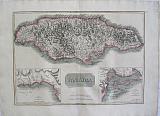 Jamaica with insets of Bluefields, and Kingston. "Jamaica; The Harbour of Bluefields; The Harbours Of Kingston and Port Royal." Edinburgh, London & Dublin John Thomson;Baldwin, Cradock, and Joy; John Cumming. 1817
Copper engraved map of Jamaica from Thomson's "A New General Atlas." Original outline colour; verso blank.
The large plate shows the island of Jamaica with inset maps, details of the bay of Bluefields in Westmoreland Parish and the harbour of Kingston showing the position of Port Royal on the Palisadoes.
The map served as the source for Fielding Lucas. Good impression; 3 tiny holes /paper faults to left blank margin; very small stain near scale, [a squashed bug?] ; old ink number to upper right corner.
444 by 680mm (17½ by 26¾ inches). €400
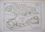
Islands of the West Indies: Martinique and Dominica.
 Martinique; the bay at Fort Royal and Dominica. "Martinico; Dominica; Cul de Sac Royal." Edinburgh, London & Dublin John Thomson;Baldwin, Cradock, and Joy; John Cumming. 1817
Copper engraved map showing Martinique and Dominica from Thomson's "A New General Atlas." Original outline colour; verso blank.
The large map shows the two islands engraved on one plate. The map of Martinique includes an inset map of the bay at Fort Royal.
The map served as the source for Fielding Lucas.
In 1635, Pierre Belain d'Esnambuc, French governor of the island of St. Kitts, landed in the harbour of St. Pierre with 150 French settlers after being driven off St. Kitts by the English. D'Esnambuc claimed Martinique for the French King Louis XIII and the French "Compagnie des Îles de l'Amérique" (Company of the American Islands), and established the first European settlement at Fort Saint-Pierre (now St. Pierre).
In 1636, the indigenous Caribs rose against the settlers to drive them off the island in the first of many skirmishes. The French successfully repelled the natives and forced them to retreat to the eastern part of the island, on the Caravelle Peninsula in the region then known as the Capesterre. When the Carib revolted against French rule in 1658, the Governor Charles Houel de Petit-Pré retaliated with war against them. Many were killed; those who survived were taken captive and expelled from the island. Some Carib had fled to Dominica or St. Vincent, where the French agreed to leave them at peace. Good impression, generally clean & bright; slight very light offsetting; tiny paper faults to left blank margin,and slight thinning in the image of Martinique; tiny pinprick to centrefold; upper general title in margin just shaved;old ink number to upper right corner.
540 by 645mm (21¼ by 25½ inches).to plate mark. €250
Islands of the West Indies: St. Vincent & Barbados.
 St. Vincent & Barbados. " St. Vincent; Barbados." Edinburgh, London & Dublin John Thomson;Baldwin, Cradock, and Joy; John Cumming. 1817
Copper engraved map showing St. Vincent & Barbados from Thomson's "A New General Atlas." Original outline colour; verso blank.
The large plate has two maps: St. Vincent & Barbados.
The map served as the source for Fielding Lucas. Good impression; small stain to scale line of St. Vincent; light vertical creases close to centre fold in map of Barbados; general title in upper margin; old ink number to upper right corner; lower edge slightly chipped.
540 by 645mm (21¼ by 25½ inches). €300
Islands of the West Indies: Porto Rico and the Virgin Islands with Haiti, St Domingo.
 Porto Rico and the Virgin Islands with Haiti, Hispaniola or St Domingo. "Porto Rico and the Virgin Islands; Haiti, Hispaniola or St Domingo" Edinburgh, London & Dublin John Thomson;Baldwin, Cradock, and Joy; John Cumming. 1817
Copper engraved map showing Porto Rico and the Virgin Islands with Haiti, St Domingo from Thomson's "A New General Atlas." Original outline colour; verso blank.
The large plate has two maps: Porto Rico and the Virgin islands to the upper part and Haiti below.
The map served as the source for Fielding Lucas. Good impression, generally clean & bright; general title in upper margin shaved; old ink number to upper right corner.
540 by 650mm (21¼ by 25½ inches). €400
Islands of the West Indies: St. Kitts & Nevis with St. Lucia.
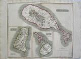 St. Kitts & Nevis with St. Lucia "St.Christophers; Nevis; St. Lucia." Edinburgh, London & Dublin John Thomson;Baldwin, Cradock, and Joy; John Cumming. 1817
Copper engraved map showing St Kitts & Nevis with St. Lucia from Thomson's "A New General Atlas." Original outline colour; verso blank.
The large plate has three maps on one plate: St. Kitts is depicted with inset smaller maps of Nevis and St. Lucia.
The map served as the source for Fielding Lucas. Good impression; short split at lower centrefold repaired with archival tape to verso; general title in upper margin; old ink number to upper right corner.
535 by 645mm (21 by 25½ inches). €200
The Islands of Bermuda & Jamaica.
 Bermuda. Jamaica. "La Jamaique aux anglois dans le Golfe du Mexique."; " La Bermude aux anglois" A Paris Par le Sr le Rouge, rue des grands Augustins 1748
Copper engraved maps [2 on 1 plate] of the island of Bermuda & Jamaica from Le Rouge's "Atlas Nouveau portatif à l'usage des Militaires et du Voyageur" Original outline colour; verso blank Good impression.
216 by 285mm (8½ by 11¼ inches). €250
The Island of Martinique.
 Martinique. "Isle de la Martinique." Paris Par le Sr le Rouge, rue des grands Augustins 1748
Copper engraved map of the island of Martinique from Le Rouge's "Atlas Nouveau portatif à l'usage des Militaires et du Voyageur" Original outline colour; verso blank Good impression; margins approx 5mm.
213 by 285mm (8½ by 11¼ inches). €80
Canada.
 "Canada ou Nouvelle France" Paris. Thierry. Denys. 1683
Copper engraved map of Eastern Canada. from Mallet's "Description de l'Univers" 1st edition. Text to verso. Dark impression; worm hole [2mm] to inner blank margin.
146 by 101mm (5¾ by 4 inches). €150
Company: Bryan, Mary Louise.
Address: Ag. Andrianoy 92 , 21 100 Nafplio, Greece.
Vat No: EL 119092581