MAPS & VIEWS
PRINTS
BOOKS
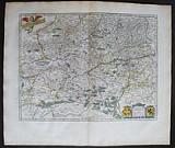
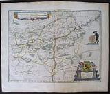
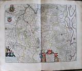
Granada and Murcia Spain.
 Granata et Murcia. "Granata et Murcia Regna." Amsterdam Apud Johannem Guiljelmi F. Blaeu. c1655
Original coloured, copper engraved map of Granata et Murcia from volume 2 of Joan Blaeu's "Theatrum Orbis terrarum, sive atlas novus. Pars secunda." Double page; folio; Latin text to verso.
Strap work title cartouche, flanked by winged and breasted lion[esses] , scale wit figure of geographer; 2 coats of arms, compass roses and sea battle .
The map shows the Kingdoms of Granada and Murcia, with part of the Straits of Gibraltar and the Barbary coast Bright original outline colour; good impression; damp stain to lower corners and upper edge, far from image.
Koeman1, Bl 24C. 377 by 497mm (14¾ by 19½ inches). €375
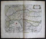
Groningen, North Holland.
 Groninga Dominium "Groninga Dominium. Auctore Bartholdo Wicheringe.." Amsterdam Apud Guiljelmum et Joahannem Blaeu. 1647
Original coloured, copper engraved map of Groningen, Northern Holland from Blaeu's "Theatrum Orbis terrarum, sive atlas novus. Partis Prima pars Altera." Double page; folio; Latin text to verso.
Decorative title cartouche surmounted by coat of arms and figures; scale with figures and animals; strap work explicatio cartouche; compass rose and ships. Original colour; damp stains to blank margins, mainly far from image, but light cockling to upper right corner within plate.
Koeman1, Bl 23A. 376 by 487mm (14¾ by 19¼ inches). €400
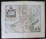
Guiana, South America.
 Guiana sive regio Amazonum. "Guiana sive Amazonum Regio." Amsterdam Apud Johannem Guiljelmi F. Blaeu. c1655
Original coloured, copper engraved map of Guiana from volume 2 of Joan Blaeu's "Theatrum Orbis terrarum, sive atlas novus .pars secunda." Double page; folio; Latin text to verso.
Strap work title catouche and scale; compass rose and ships to sea.
Decorative map of the Guianas , Lake Parima (Parime Lacus), and the route to El Dorado.Initially issued in 1630 , variants were published well in to the 1660s. The map covers from Isla Margarita and the Orinoco Delta eastward as far as Tampico and southwards as far as the Amazon River.
This region of South America generated considerable European interest in the early 17th century following the publication of Sir Walter Raleigh's fascinating 'Discovery of the Large, Rich, and Beautiful EMPIRE Of GUIANA .' Raleigh's expedition traveled down the Orinoco River in search of the Kingdom of El Dorado. Today we know that El Dorado did not exist, but was rather an amalgam of very real tribal traditions and the European lust for gold. Nonetheless, in the 16th century, tales of El Dorado were common conversation along the port cities of the Spanish Main. Having explored a considerable distance down the Orinoco, Raleigh's expedition found itself mired in a remote tribal village at the onset of the rainy season. While waiting for an opportunity to return north, a trading delegation arrived. At this time the dominate trading empire in the Amazon were the Manoa, who, though based near modern day Manaus, pursued trade routes to from the foothills of the Andes to the Amazon and Orinoco Deltas. While the rainy season prevented Raleigh from moving forward, for the Manoa it had the opposite effect. The heavy rains inundated the vast Parima flood plain creating a great inland sea, consequently opening an important trade connection between the Amazon and Orinoco Rivers. When the Manoa arrived, Raleigh and his men noticed that they had various golden trinkets for sale. This was apparently enough for Raleigh to deduce that they must indeed be from the hidden kingdom of El Dorado. When Raleigh asked where the traders came from, the locals, with no common language with which to engage Raleigh, could only explain that they traveled across a great water and were from Manoa. Raleigh's presumptuous narrative inspired many early cartographers to map this massive lake, with the city of El Dorado or Manoa on its shores, in the unexplored lands between the Orinoco and Amazon River basins. Bright original outline colour; good impression; damp stain to edges of blank margins, far from image.
Koeman1, Bl 24C. 376 by 494mm (14¾ by 19½ inches). €400
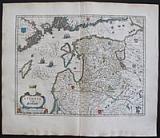
Hainaut and Namur.
 Hannonia Comitatus. " Comitatuum Hannoniæ et Namurci Descriptio." Amsterdam Apud Guiljelmum et Joahannem Blaeu. 1647
Original coloured, copper engraved map of Hainaut and Namur from Blaeu's "Theatrum Orbis terrarum, sive atlas novus .Partis Prima pars Altera." Double page; folio; Latin text to verso.
Decorative title cartouche flanked by coats of arms; Scale held by large putti.
The map shows the area of Hainault and Namur. Bright original colour; damp stain upper and lower edges of blank margin, far from image.
Koeman1, Bl 23A. 380 by 500mm (15 by 19¾ inches). €200
South Holland.
 Hollandia Australis, vulgo Zuyd-Holland. "Zuydhollandia stricte sumta." Amsterdam Apud Guiljelmum et Joahannem Blaeu. 1647
Original coloured, copper engraved map of South Holland from Blaeu's "Theatrum Orbis terrarum, sive atlas novus. Partis Prima pars Altera." Double page; folio; Latin text to verso.
Decorative title cartouche; ship and compass rose.
. Original colour; drop of wax[?] to left lower plate mark and rust spot and scattered small grey spotting to lower blank margin; light damp stain to upper edge of blank margin.
Koeman1, Bl 21A. 384 by 511mm (15 by 20 inches). €350
Holland
 Hollandia. "Hollandia Comitatus. " Amsterdam Apud Guiljelmum et Joahannem Blaeu. 1647
Original coloured, copper engraved map of Holland from Blaeu's "Theatrum Orbis terrarum, sive atlas novus .Partis Prima pars Altera." Double page; folio; Latin text to verso.
Strap work title cartouche; scale on plinth with figure of geographer; coat of arms of lion rampant surrounded by wreath; empty cartouche to lower left corner surmounted by lion; inset map with decorative frame; ships and compass roses.
Blaeu's decorative map of Holland with an inset of the Dutch Islands of Texel, Vlielandt, etc. Original colour; light damp stain to edges of blank margins.
Koeman1, Bl 23A. 390 by 522mm (15¼ by 20½ inches). €1000
The Kingdoms of Fez and Marocco.
 Imperium Fessanum. "Fezzæ et Marocchi Regna Africæ Celeberima describebat Abrah. orteius.." Amsterdam: Apud Johannem Guiljelmi F. Blaeu. 1655
Copper engraved map of Fez and Marocco from volume 2 of Joan Blaeu's "Theatrum Orbis terrarum, sive atlas novus .pars secunda."Original outline colour. Double page; folio; Latin text to verso..
Decorative title cartouche; ships to sea.
The map is after the desription of Ortelius. Original outline colour; good impression; light toning due to former framing; light toning to edges of page; a couple of spots to blank margins; centre fold split to lower blank margin, repared with archival tape to verso.
Koeman1, Bl 24C. 393 by 500mm (15½ by 19¾ inches). €350
The Carribbean.
 Insulæ Americanæ, in Oceano Septemtrionali, Ante sinum Mexicanum, & aliquot Continentis regiones. "Insulæ Americanæ, in Oceano Septemtrionali cum Terris adiacentibus." Amsterdam Apud Johannem Guiljelmi F. Blaeu. c1655
Original coloured, copper engraved map of the Caribbean from volume 2 of Joan Blaeu's "Theatrum Orbis terrarum, sive atlas novus .pars secunda." Double page; folio; Latin text to verso.
Large strap work title cartouche and scale: dedication cartouche surmounted by coat of arms; ships and compass roses to sea.
Blaeu's chart of the Caribbean, based on a section of Blaeu's own West Indische Paskaert (ca. 1630) and Hessel Gerritsz' rare chart of 1631. The chart was the most accurate for its time and was used throughout the seventeenth century.
The chart covers practically the same area as the Gerritsz chart, but adds the west coast of Central America and the South Sea ( Mare del Zur). Although this western coast is shown on the chart, there are no place names there. Every other coast is detailed in its toponyms, reflecting the advanced nature of European colonialism in the mid-seventeenth century. The place names in Florida and what is now the US Gulf Coast are mostly Spanish in origin, suggesting the use of a hard-to-get Spanish chart for that section.
The place names along the coast of eastern North America are practically identical to the Gerritsz chart, other than the important addition of Virginia here. According to Burden, Blaeu also accurately shows the distance between Chesapeake Bay and Albemarle Sound to be only 1°, whereas many contemporaries show them a further distance from each other.
The coastlines are colored decoratively, not to reflect political boundaries. The map is embellished with several other aesthetic details that make it distinctive to other charts of the area based on Gerritsz. A delicate scrolling script and rhumb lines fill the seas, as do five ships in full sail. The ships underline the region's importance to Europeans; it was a major center for trade, resources, and a site for forced labor. Bright original outline colour; good impression; light damp stain and toning to edges of blank margins.
Koeman1, Bl 24C. 383 by 526mm (15 by 20¾ inches). €1300
Croatia, Slovenia, Istria.
 Karstia, Carniola, Histria et Windorum Marchia, & Comitaus Cilia. "Karstia, Carniola, Histria et Windorum Marcia. Ger. Mercatore Auctore" Amsterdam Apud Guiljelmum et Joahannem Blaeu. 1647
Original coloured, copper engraved map of Friuli, Istria and surrounds from volume 1 of Blaeu's "Theatrum Orbis terrarum, sive atlas novus ." Double page; folio; Latin text to verso.
The map shows the region of that is now Slovenia and Croatia; the coast and the peninsular of Istria with the islands.
Decorative title cartouche, compass rose and ship to sea. Original colour; light toning to edges of blank margins.
Koeman1, Bl 23A. 386 by 500mm (15¼ by 19¾ inches). €500
Famous Figure map of Africa.
 L'Afrique "Africæ nova descriptio. Auct. Guiljelmo Blaeuw." Amsterdam Chez Jean & Corneille Blaeu. c1640
Original coloured, copper engraved figure map of Africa from volume 2 of Joan Blaeu's "Le Theatre du Monde ou Nouvel Atlas." Double page; folio; French text to verso.
The famous figure map of Guillaume Blaeu has 9 town views in upper border and 10 costumed figures in side borders, there are numerous galleons and monsters to the sea; lions, elephants and other wild animals to the body of the map. "This is one of the most decorative and popular of all the early maps of Africa" (Norwich 32).
Much of the geographical information is still based on the Ptolemaic maps, with the Nile shown with its source in the Lakes Zaire and Zaflan. Also included are various other mythical lakes and rivers including the famous Lake Sachaf of Laurent Fries. Original outline colour; good impression; evenly toned due to previous framing;brown paper tape to edges of verso, due to framing. some light spotting,1 darker spot to lower left above Privilege; lower centre fold split,repaired to verso.
Koeman1, Bl 17[ 1/A]. 414 by 555mm (16¼ by 21¾ inches). €3200
León And Asturias.
 Legio et Asturia. "Legionis Regnum et Asturiarum Principatus." Amsterdam Apud Johannem Guiljelmi F. Blaeu. c1655
Original coloured, copper engraved map of Asturias and León from volume 2 of Joan Blaeu's "Theatrum Orbis terrarum, sive atlas novus. Pars secunda." Double page; folio; Latin text to verso.
Decorative title cartouche surrmounted by coat of arms and flanked by lions; compass rose to sea;Strap work scale. Bright original outline colour; good impression; damp stain to lower corners far from image.
Koeman1, Bl 24C. 380 by 502mm (15 by 19¾ inches). €300
Leige.
 Leodiensis Episcopatus " Leodiensis Diocesis." Amsterdam Apud Guiljelmum et Joahannem Blaeu. 1647
Original coloured, copper engraved map of the Diocese of Leige from Blaeu's "Theatrum Orbis terrarum, sive atlas novus .Partis Prima pars Altera." Double page; folio; Latin text to verso.
Decorative title cartouche surmounted by coats of arms and flanked by putti; strap work scale cartouche; compass rose. Bright original colour; damp stain upper and lower edges of blank margin, two creases to upper right corner.
Koeman1, Bl 23A. 378 by 497mm (15 by 19½ inches). €300
Duchy of Limburg.
 Limburgum Ducatus. "Ducatus Limburgem Auctore Ægidio Martini." Amsterdam Apud Guiljelmum et Joahannem Blaeu. 1647
Original coloured, copper engraved map of the Duchy of Limburg from Blaeu's "Theatrum Orbis terrarum, sive atlas novus .Partis Prima pars Altera." Double page; folio; Latin text to verso.
Large decorative title cartouche surmounted by putti; holding coat of arms.
The map prepared by Ægidio Martini shows the border area with the cities of Maestrict, Leige And Limburg.
The Duchy of Limburg or Limbourg was a state of the Holy Roman Empire. Its main territory, including the capital Limbourg,is today located within the Belgian province of Liège, with a small part in the neighbouring province of Belgian Limburg. Bright original colour; light damp stain to lower edge of blank margin; small brown spot at foot of centre fold, far from image.
Koeman1, Bl 23A. 382 by 505mm (15 by 20 inches). €400
Livonia, the Baltic States of Latvia and Estonia.
 Livonia vulgo Lyfeland. "Livonia vulgo Lyfeland." Amsterdam Apud Johannem Guiljelmi F. Blaeu. c1645
Original coloured, copper engraved map of Livonia from Joan Blaeu's "Theatrum Orbis terrarum, sive atlas novus ." Double page; folio; Latin text to verso.
Decorative cartouche; ships to sea and shields with coats of arms to body of map.
The map shows the historical region of Livonia, present day Latvia and Estonia, on the Baltic Sea. Bright original outline colour; good impression dampstain to edges of lower blank margin, far from image.
Koeman1, Bl 23A. 387 by 506mm (15¼ by 20 inches). €500
Duchy of Luxembourg.
 Lutzenburgensis Ducatus. " Lutzenburg Ducatus ." Amsterdam Apud Guiljelmum et Joahannem Blaeu. 1647
Original coloured, copper engraved map of the Duchy of Luxembourg from Blaeu's "Theatrum Orbis terrarum, sive atlas novus .Partis Prima pars Altera." Double page; folio; Latin text to verso.
Title cartouche surmounted by coat of arms. Bright original colour; light damp stain to lower edge of blank margin; small brown spot at foot of centre fold, far from image.
Koeman1, Bl 23A. 378 by 498mm (15 by 19½ inches). €450
Mechelen.
 Mechlinia Dominium. " Mechlinia Dominium et Aberchot Ducatus. Auctore Michaele Flor; a Langren regis Catholici Mathmatico." Amsterdam Apud Guiljelmum et Joahannem Blaeu. 1647
Original coloured, copper engraved map of Mechelen from Blaeu's "Theatrum Orbis terrarum, sive atlas novus .Partis Prima pars Altera." Double page; folio; Latin text to verso.
Large decorative title cartouche surmounted by coats of arms and flanked by allegorical figures; large strap work scale cartouche with putti; strap work explicatory cartouche.
Detailed map showing the area of Mechelen . Bright original colour; damp stain upper and lower edges of blank margin, spot to bottom of centre fold, far from image.
Koeman1, Bl 23A. 412 by 524mm (16¼ by 20¾ inches). €250
Northern Russia.
 Moscoviæ Pars Sept. & Orient "Russiæ, vulgo Moscovia dicta Partes Septentrionalis et Orientalis." Amsterdam Apud Johannem Guiljelmi F. Blaeu. c1645
Original coloured, copper engraved map of Northern & Eastern Russia from Joan Blaeu's "Theatrum Orbis terrarum, sive atlas novus ." Double page; folio; Latin text to verso.
Strap work cartouche & scale; coat of arms; ship to sea and animals to body of map.
The map shows the Northern part of Russia from Finland to just beyond the Jenisej River and south to the Volga River including the cities of Jaroslavl, Niznij Novgorod, and Kazan, with Tobolsk to the Northeast. Bright original outline colour; good impression; small dampstains to upper edge and larger dampstains to lower blank margin, far from image.
Koeman1, Bl 23A. 420 by 542mm (16½ by 21¼ inches). €450
County of Namur.
 Namurcum Comitatus. " Namurcum Comitatus. Auctore Johann Surhonio." Amsterdam Apud Guiljelmum et Joahannem Blaeu. 1647
Original coloured, copper engraved map of Namur from Blaeu's "Theatrum Orbis terrarum, sive atlas novus .Partis Prima pars Altera." Double page; folio; Latin text to verso.
Decorative title cartouche surmounted by coats of arms; large strap work scale cartouche; compass on pedestal held by figure.
The map shows the county of Namur. Bright original colour; damp stain upper and lower edges of blank margin, far from image.
Koeman1, Bl 23A. 410 by 526mm (16¼ by 20¾ inches). €200
Natolia.
 Natolia sive Asia Minor. "Natolia, quæ olim Asia Minor." Amsterdam Apud Johannem Guiljelmi F. Blaeu. c1655
Original coloured, copper engraved map of Natolia from volume 2 of Joan Blaeu's "Theatrum Orbis terrarum, sive atlas novus .pars secunda." Double page; folio; Latin text to verso.
Strap work title cartouche; sea battle to sea.
The map shows Natolia, or Asia Minor, modern day Turkey, with the adjacent islands including Cyprus. Bright original outline colour; good impression; light damp stain to lower corners far from image.
Koeman1, Bl 24C.;Zacharakis:381/243;Navari, Leonora (ed.) Maps of Cyprus: From the Collections of the Bank of Cyprus Cultural Foundation, #66; Stylianou, #112; Ioannou, #51. 384 by 498mm (15 by 19½ inches). €400
The Kingdom of Navarre
 Navarra Regnum. "Navarra Regnum." Amsterdam Apud Johannem Guiljelmi F. Blaeu. c1655
Original coloured, copper engraved map of Navarre from volume 2 of Joan Blaeu's "Theatrum Orbis terrarum, sive atlas novus. Pars secunda." Double page; folio; Latin text to verso.
Decorative title cartouche surrounded by soldiers; large coat of arms ; strap work scale; 4 further coats of arms. Bright original outline colour; good impression; damp stain to lower corners far from image.
Koeman1, Bl 24C. 418 by 520mm (16½ by 20½ inches). €350
Mexico, Novea hispania.
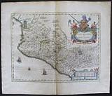 Nova Hispania. "Nova Hispania et Nova Galicia." Amsterdam Apud Johannem Guiljelmi F. Blaeu. c1655
Original coloured, copper engraved map of Mexico from volume 2 of Joan Blaeu's "Theatrum Orbis terrarum, sive atlas novus .pars secunda." Double page; folio; Latin text to verso.
Large decorative title catouche ; ships and compass rose to sea.
Map of Mexico extending from just north of Mazatlan to Acapulco and from Tehuacan to the Sierra Madres, showing Mexico City, Puebla (Angelorum Civitas), Colima, Campostella, Purificatio and Mechoacan as the major cities of the time.
Based on Ortelius's map of 1579 which became the basis for many of the seventeenth century maps of the area.
Despite the implications in the title, the map does not cover all of the provinces of New Spain, only a portion of modern Mexico. At the time, the region was described as being rich in gold & silver, with pearl-fishing carried on in the coastal regions. The numerous salt lakes produced the finest salt by means of evaporation, and much was made of the sugar-cane cultivated here.
In the east of the mapped area, below the large title cartouche may be seen the area of Mexico city, situated on the shores of a large lake, described as an ample city, queen of all the cities in the New World. Although the mapmaker gave no clues, the small lozenge shaped symbols to the left of the cartouche probably indicate gold or silver mines.
The elaborate title cartouche is surrounded by the Spanish Royal Coat of arms. Bright original outline colour; good impression; light damp stain to edges of blank margins, far from image.
Koeman1, Bl 24C. 385 by 502mm (15¼ by 19¾ inches). €500
The North Pole.
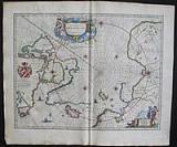 Polus Arcticus. "Regiones Sub Polo Artico. Auctore Guiljelmo Blaeu." Amsterdam Apud Johannem Guiljelmi F. Blaeu. c1645
Original coloured, copper engraved map of the North Pole from Joan Blaeu's "Theatrum Orbis terrarum, sive atlas novus ." Double page; folio; Latin text to verso.
Blaeu`s beautifully engraved map of the arctic was first issued c.1638 and is a precise copy of a map issued by Janssonius the previous year. Burden notes "even the cartouches are the same. But Janssonius has placed his imprint in the lower right cartouche; Blaeu has the scale here." Along with the original Janssonius, Blaeu's map "provides the first detailed summary of the 16th and early 17th century Canadian arctic discoveries" (Kershaw).
To the left we see the discoveries of captain Thomas James of Bristol along the southern and western shores of the Hudson Bay during his expedition of 1631/32 (with, among others, "James his Bay"). Spitsbergen is drawn as it was known after the Danish expeditions of 1605-1607.
The map provides the best view of the period of discoveries in the area of Hudson's and Baffin's Bays as well as Davis Strait. It is a vast improvement over the Mercator map of the region, whose North Pole was filled with mythical islands.
In its day this map was the most up-to-date map of the North Pole region available. Bright original outline colour; good impression; light stain to lower right blank margin.
Koeman1, Bl 23A; Burden 252. 415 by 532mm (16¼ by 21 inches). €900
Portugal.
 Portugalia nec non Algarbia. "Portugalia et Algarbia quæ olim Lusitania. Auctore Vermando Alverrro Secco." Amsterdam Apud Johannem Guiljelmi F. Blaeu. c1655
Original coloured, copper engraved map of Portugal from volume 2 of Joan Blaeu's "Theatrum Orbis terrarum, sive atlas novus. Pars secunda." Double page; folio; Latin text to verso.
Decorative title cartouche flanked by 2 Arab geographers; strap work scale; 2 coast of arms; compass roses, ships and Posidon to sea.
After the map by Fernando Alvares Seco, who is credited with creating the first modern map of Portugal.
The Arabic figures on either side of the title cartouche represent the earlier period in Portugal's history when Algarve and Portugal to the south of the Tejo were under Muslim dominion. Bright original outline colour; good impression; damp stain to lower corners and upper edge, far from image.
Koeman1, Bl 24C. 380 by 500mm (15 by 19¾ inches). €600
Prussia.
 Prussia. "Prussia Accurata Descripta a Gasparo Henneberg Erlichsi. " Amsterdam Apud Guiljelmum et Joahannem Blaeu. 1647
Original coloured, copper engraved map of Prussia from volume 1 of Blaeu's "Theatrum Orbis terrarum, sive atlas novus ." Double page; folio; Latin text to verso.
Decorative title cartouche surmounted by coat of arms and flanked by allegorical figures ships to the sea. Original colour; light damp stain to edge of lower blank margin; short centre fold split at lower blank margin ..
Koeman1, Bl 23A. 395 by 505mm (15½ by 20 inches). €450
The Kingdom of Prester John.
 Regnum Abissinorum. "Æthiopia Superior vel Inferior: vulgo Abissinorum sive Pesbiteri Joannis Imperium." Amsterdam: Apud Johannem Guiljelmi F. Blaeu. 1655
Copper engraved map of East Africa from volume 2 of Joan Blaeu's "Theatrum Orbis terrarum, sive atlas novus .pars secunda."Original outline colour. Double page; folio; Latin text to verso..
Decorative title cartouche; ships to sea; elephants, ostriches and monkeys to the interiors of the countries.
Two Ptolemaic lakes, Zair and Zaflan are shown in the southern portion of the map as being the main source of the Nile. Lake Niger is shown as the source of the Niger River, flowing westward. The map contains numerous coastal place names such as Mozambique Island, Quiloa, Mombaza, and Melinde indicating the importance of the area to both Arab and Portuguese traders and explorers from other countries
Prester John was believed to be a Christian king of enormous power and splendor. The legend first appeared in the 1100's with his kingdom believed to be in Asia, but as the area was further explored, the location of this mythical kingdom moved to the Middle East and eventually present day Ethiopia. This legend persisted for centuries. When Vasco de Gama went on his voyage from Mozambique north in the 1400's, he heard that "Preste Johan" ruled the interior. Original outline colour; good impression; light browning to edges of plate mark due to former framing; light toning to edges of page. Split to lower centre fold [not entering plate] repaired with archival tape, to verso.
Koeman1, Bl 24C. 385 by 500mm (15¼ by 19¾ inches). €500
Central Holland.
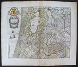 Rhenolandia. "Rhenolandiæ et Amstellandiæ exactisima Tabula. " Amsterdam Apud Guiljelmum et Joahannem Blaeu. 1647
Original coloured, copper engraved map of North Holland from Blaeu's "Theatrum Orbis terrarum, sive atlas novus. Partis Prima pars Altera." Double page; folio; Latin text to verso.
Decorative title cartouche; by coat of arms within wreath; Strapwork key to lower right corner; ships and compass roses.
The map shows Central Holland, Leyden, Haarlem, Amsterdam and Gouda. Original colour; light damp stain to edges of blank margins.
Koeman1, Bl 23A. 408 by 502mm (16 by 19¾ inches). €500
Serbia, Bulgaria, Romania & Wallachia.
 Servia, Walachia, Bulgaria & Romania ""Walachia Servia, Bulgaria, Romania "" Amsterdam Apud Guiljelmum et Joahannem Blaeu. 1647
Original coloured, copper engraved map of Serbia, Bulgaria, Romania & Wallachia from volume 1 of Blaeu's "Theatrum Orbis terrarum, sive atlas novus ." Double page; folio; Latin text to verso.
The map after Mercator, shows part of the Ottoman Empire: the countries of the Balkans, including part of the Greek province of Macedonia across to the Albanian coast with part of Moldavia to the north.
Decorative title cartouche surmounted by Ottoman weapons and shield. Original colour; light toning to edges of blank margins.
Koeman1, Bl 23A. 387 by 507mm (15¼ by 20 inches). €400
Tartary.
 Tartaria sive Magni Chami Imperium. "Tartaria sive Magni Chami Imperium." Amsterdam Apud Johannem Guiljelmi F. Blaeu. c1655
Original coloured, copper engraved map of Tartary from volume 2 of Joan Blaeu's "Theatrum Orbis terrarum, sive atlas novus .pars secunda." Double page; folio; Latin text to verso.
Decorative title cartouche in the shape of a camel; strap work scale.
The map shows, North and North Eastern Asia: the Kingdom of Tartary, covering the area from the Caspian sea to the Pacific Ocean,O within the map references to mythical creatures and legends, like the devils and dragons in the Lop desert to the west of the Great Wall of China. Much of this information comes from the travel accounts of Marco Polo. Bright original outline colour; good impression; light damp stain to lower corners far from image.
Koeman1, Bl 24C. 380 by 495mm (15 by 19½ inches). €500
Crimea, Ukraine.
 Taurica Chersonesus. ""Taurica Chersonesus Nostra ætate Prezecop et Gazara dicitur"." Amsterdam Apud Guiljelmum et Joahannem Blaeu. 1647
Original coloured, copper engraved map of Crimea and part of Ukraine from Blaeu's "Theatrum Orbis terrarum, sive atlas novus ." Double page; folio; Latin text to verso.
The map after Mercator shows the Crimean Peninsular on the Black Sea with the land now Ukraine and part of Asia minor. Original colour; light toning to edges of blank margins.
Koeman1, Bl 23A. 380 by 500mm (15 by 19¾ inches). €400
Brabant: Antwerp.
 Tertia pars Brabantia civitas Antwerpia et Marchionatus S.R.Imperii. "Tertia pars Brabantia qua continetur Marchionat.S.R.I horum urbs primaria Antverpia.." Amsterdam Apud Guiljelmum et Joahannem Blaeu. 1647
Original coloured, copper engraved map of the area round Antwerp from Blaeu's "Theatrum Orbis terrarum, sive atlas novus .Partis Prima pars Altera." Double page; folio; Latin text to verso.
Decorative title cartouche surrounded by coats of arms; scale surmounted by figures of geographers; coats of arms upper right.
The map shows the area around Antwerp extending from Leuven at the left of plate, Antwerp at top, and Breda to the right of plate. Bright original colour; damp stain to upper corners, and edge of lower blank margin, far from image.
Koeman1, Bl 23A. 420 by 524mm (16½ by 20¾ inches). €300
Company: Bryan, Mary Louise.
Address: Ag. Andrianoy 92 , 21 100 Nafplio, Greece.
Vat No: EL 119092581