MAPS & VIEWS
PRINTS
BOOKS
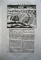
Tripolis, Libya.
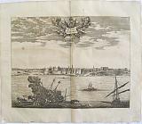 The City of Tripolis. " De Stadt Tripolis. La Ville de Tripoli." Amsterdam Wolfgangh, Waesbergen, Boom. Someren en Goethals 1686
Copper engraved double page view of Tripolis, Libya from Olfert Dapper's "Description de l'Afrique," the first edition in French; black and white, verso blank.
The view shows the port of Tripolis, capital of Libya with ships engaged in battle to the foreground. Title on decorative banner to sky. Dark impression; light toning; a few spots to image one darker to left sky; old ink number to upper margin.
Mendelssohn I, p.413. Cox I, p. 361; Gay 219. 270 by 352mm (10¾ by 13¾ inches). €200
Fort Tacaray also known as Fort Witsen on the Gold Coast, Ghana.
 Jacob van Meurs.
The Fort Tacaray "Y Fort Tacaray" Amsterdam Wolfgangh, Waesbergen, Boom. Someren en Goethals 1686
Jacob van Meurs.
The Fort Tacaray "Y Fort Tacaray" Amsterdam Wolfgangh, Waesbergen, Boom. Someren en Goethals 1686Copper engraved double page view of the fort of Tacaray Ghana, from Olfert Dapper's "Description de l'Afrique," the first edition in French; black and white, verso blank.
The view shows small fort on the Gold Coast, Ghana with Dutch ships of the VOC to the foreground.
Fort Tacaray, also Fort Witsen, was a fort on the Dutch Gold Coast, established in 1656 near Takoradi. This fort was destroyed after a few years, and in 1684 the site was abandoned. Dark impression; light toning; some spotting; old ink number to upper margin.
Mendelssohn I, p.413. Cox I, p. 361; Gay 219. 255 by 346mm (10 by 13½ inches). €120
Korinthia/ Corinth, Peloponessus
 The Grave of Diogenes the Cynic "Het Graf von Diogenes Cynikus. " Amsterdam Wolfgangh, Waesbergen, Boom. Someren en Goethals
 Copper engraved view of the grave of Diogenes Cynikus. Set in a page of Dutch text[page 51] from Olfert Dapper's" Naukeurige Beschryving van Morea" 1688. Single page; folio; text to verso Dark impression, wide margins.
130 by 165mm (5 by 6½ inches). €30
Cabo Verde, The Cape Verde Islands.
 The Islands of Cape Verde. "Insulæ Promontorii Viridis, Hhispanis Issas de Cabo Verde, BelgisDe Soute Eylanden." Amsterdam Wolfgangh, Waesbergen, Boom. Someren en Goethals 1686
Copper engraved double page map of the cape Verde Islands, from Olfert Dapper's "Description de l'Afrique," the first edition in French; black and white, verso blank.
Decorative title cartouche and scale; compass rose to sea. Dark impression; light toning; slight offsetting; occasional spotting mainly to blank margins, a few to image, one to lower right corner and another to title with a third near scale; old ink number to upper margin; chips to lower side edges far from image.
Mendelssohn I, p.413. Cox I, p. 361; Gay 219. 283 by 317mm (11¼ by 12½ inches). €250
Marrakech, Former Imperial Capital of Morocco.
 Jacob van Meurs.
The Royal Palace and part of the city of Morocco. "Het Koninklyk Hof met een gedeelte der Stadt Marokko. Le Palais et une partie de la ville Maroc." Amsterdam Wolfgangh, Waesbergen, Boom. Someren en Goethals 1686
Jacob van Meurs.
The Royal Palace and part of the city of Morocco. "Het Koninklyk Hof met een gedeelte der Stadt Marokko. Le Palais et une partie de la ville Maroc." Amsterdam Wolfgangh, Waesbergen, Boom. Someren en Goethals 1686Copper engraved double page view of Marrakech, Morocco from Olfert Dapper's "Description de l'Afrique," the first edition in French; black and white, verso blank; key to both upper corners in Dutch & French identifying significant landmarks. Ornate title cartouche to sky.
The plate shows the city from outside the walls with the Atlas mountains in the background. in the foreground locals are collecting water from a well, with travellers in the mid ground.
Marrakech is the most important of Morocco's four former imperial cities. The city was founded in 1062 The red walls of the city, built by Ali ibn Yusuf in 1122-1123, and various buildings constructed in red sandstone during this period, have given the city the nickname of the "Red City" or "Ochre City".
Marrakesh grew rapidly and established itself as a cultural, religious, and trading centre for the Maghreb and sub-Saharan Africa.
After a period of decline, the city was surpassed by Fes, but in the early 16th century, Marrakesh again became the capital of the kingdom. The city regained its preeminence under wealthy Saadian sultans Abu Abdallah al-Qaim and Ahmad al-Mansur, who embellished the city with sumptuous palaces such as the El Badi Palace (1578) and restored many ruined monuments.
Beginning in the 17th century, the city became popular among Sufi pilgrims for Morocco's seven patron saints, who are entombed there. Dark impression; light toning; some spotting mainly to blank margins; old ink number to upper margin.
Mendelssohn I, p.413. Cox I, p. 361; Gay 219. 267 by 347mm (10½ by 13¾ inches). €250
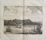
The Pirate Port of Gigery, Jijel, Algeria.
 Jacob van Meurs.
The Town of Gigeri. "De Stadt Gigeri. La Ville Gegery" Amsterdam Wolfgangh, Waesbergen, Boom. Someren en Goethals 1686
Jacob van Meurs.
The Town of Gigeri. "De Stadt Gigeri. La Ville Gegery" Amsterdam Wolfgangh, Waesbergen, Boom. Someren en Goethals 1686Copper engraved double page view of theport of Gigeri [Jijel,] Algeria , from Olfert Dapper's "Description de l'Afrique," the first edition in French; black and white, verso blank; key in the upper corners in Dutch & French.
The view shows the town of Gigeri, [now Jijel] Algeria; ships and galleys to foreground
Under the Ottomans, the city of Jijel became an important port for pirate activity, it was the city of many renowned privateers, including the Brothers Barbarossa who were active there from 1514, fighting the Spanish Christians who had invaded parts of Algeria.
The city also received many refugees expelled from Spain for their Muslim religion. Dark impression; light toning; some spotting; old ink number to upper margin.
Mendelssohn I, p.413. Cox I, p. 361; Gay 219. 230 by 310mm (9 by 12¼ inches). €180
Tunis,
 Tunis. " Thunis." Amsterdam Wolfgangh, Waesbergen, Boom. Someren en Goethals 1686
Copper engraved double page view of Tunis, from Olfert Dapper's "Description de l'Afrique," the first edition in French; black and white, verso blank.
The view shows the port of Tunis, with ships to the foreground. Key to both upper corners in Dutch & French, identifying significant landmarks; title on decorative banner to sky. Dark impression; light toning; Some spotting mainly to blank margins; old ink number to upper margin; crease to centre fold with splits repaired to verso ; short tear to right blank margin on crease, repaired to verso.
Mendelssohn I, p.413. Cox I, p. 361; Gay 219. 266 by 346mm (10½ by 13½ inches). €150
Hottentots, South Africa.
 Jacob van Meurs.
Weapons and Dress of the Hottentots. "Draht en Wapening der Hottentots. Armes et Habits des Hottentots" Amsterdam Wolfgangh, Waesbergen, Boom. Someren en Goethals 1686
Jacob van Meurs.
Weapons and Dress of the Hottentots. "Draht en Wapening der Hottentots. Armes et Habits des Hottentots" Amsterdam Wolfgangh, Waesbergen, Boom. Someren en Goethals 1686Copper engraved double page engraving of Hottentots from South Africa, from OlfertDapper's "Description de l'Afrique," the first edition in French. black and white, verso blank.
The engraving shows a group of natives of South Africa: two women, one with a child carried on her back andthree men, one a hunter carrying a spear and bow and arrows. Dark impression; light toning;occasional spotting mainly to blank margins; old ink number to upper margin,; chips to lower side edges far from image.
Mendelssohn I, p.413. Cox I, p. 361; Gay 219. 246 by 357mm (9¾ by 14 inches). €100
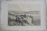
Isthmus of Corinth/Korinth, Peloponessus.
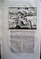 "De Stad en Kasteel van Korinthen" Amsterdam Wolfgangh, Waesbergen, Boom. Someren en Goethals 1688
Copper engraved birdseye view of the Isthmus of Corinth. Set in a page of Dutch text [page 34] from Dapper's " Naukerurige Beschryving van Morea"1688. single page; folio; text to verso.
The view shows the Isthmus of Corinth from the Peloponnesus towards Attica. with the Acrocorinth in the foreground. Dark impression, wide margins.
124 by 158mm (5 by 6¼ inches). €160
Bosphorus, Turkey.
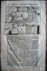 "Het Kanal van Constantinopolen" Amsterdam Wolfgangh, Waesbergen, Boom. Someren en Goethals 1688
Copper engraved map of the Bosphorus. Set in a page of Dutch text. [page22]
From Olfert Dapper's" Naukeurige Beschryving der Eilanden in de Archipel der Middelantsche Zee"1688. Single page, folio, text to verso. good impression. wide margins. Some show through from text on verso.
Zacherakis1324 125 by 157mm (5 by 6¼ inches). €100
Kalamata/Calamata, Messania, Pelopenessus
 "La Bataille devant Calamata" Amsterdam Wolfgangh, Waesbergen, Boom. Someren en Goethals 1688
Copper engraved Birds eye view of the battle of Kalamata. set in a page of text in Dutch, [page 44]. From Olfert Dapper's" Beschryving van Morea "1688. Sharp impression. with wide margins, single page. foilo, text to verso.
130 by 165mm (5 by 6½ inches). €120
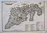
Pelponnesus/Morea.
 Jac. Meursium/Jacob van Meurs
"Peloponnesus sive Morea" Amsterdam Wolfgangh, Waesbergen, Boom. Someren en Goethals 1688
Jac. Meursium/Jacob van Meurs
"Peloponnesus sive Morea" Amsterdam Wolfgangh, Waesbergen, Boom. Someren en Goethals 1688Copper engraved. double page map, by Jac. Mersius from Dapper's"Beschryving van Morea" 1688. Folio, verso blank. Decorative allagorical cartouche. Dark impression with wide margins Small centre fold split to lower margin
Zacharakis 1284/872 305 by 355mm (12 by 14 inches). €750
Sitia, Crete
 "Stad Sitia of Setia" Amsterdam Wolfgangh, Waesbergen, Boom. Someren en Goethals 1688
Copper engraved birdseye view Sitia in Crete. Set in a page of Dutch text [page 215].
From Olfert Dapper's" Naukeurige Beschryving der Eilanden in de Archipel der Middelantsche Zee"1688. Single page, folio, text to verso. Dark impression with wide margins.
134 by 167mm (5¼ by 6½ inches). €140
Portugal and her Frontiers with Spain.
 The Frontiers of Spain and Portugal. "Les Frontiers d'Espagne et de Portugal, ou se trouve Le royaume de Portugal divise en ses Cinq Grandes Provinces.... Partie des Royaume de Grenade, d'Andalouse ,de Castille ..." Paris de Fer. N 1705
Copper engraved map of Portugal and part of Spain by Nicholas de Fer from his "Atlas ou Recueil de Cartes Geographiques" Original old full wash colour; verso blank.
The map shows the south western part of the Iberian peninsular: Portugal; the Algarve, and parts of the kingdoms of Estramadura, Andalusia,Grenada, Leon and Castille extending down to the straits of Gibraltar. Good dark impression; colours bright; old ink number to upper blank margin; guard attached to upper margin; light diagonal creases towards centre fold other small printers creases/ wrinkles to centrefold; old ink title to verso.
Pastoureau, FER II C [72]. 577 by 436mm (22¾ by 17¼ inches). €650
Martinique.
 The Island of Martinique. "Isle de la Martinique." Paris de Fer, Nicolas 1704
Copper engraved map of Martinique from Nicolas de Fer's "Alas Curieux", Original colour; verso blank.
Detailed map engraved by P Starckman, with long key identifying 63 places of interest Dark impression; upper margin trimmed to plate mark; crease to lower right corner;ink number to upper right corner.
261 by 364mm (10¼ by 14¼ inches). €280
View of Macri from Telmessus.
 Macri from the Theatre of Telmessus. "Macri from the Theatre of Telmessus.." London. Dickenson & Co., Printsellers and Publishers to the Queen , 114 New Bond Street. 1847
Tinted lithograph view of Macri from Telmessus from Captain, the Hon. Walter Bourchier Devereux's "Views on the Shores of the Mediterranean."
The view shows the town and port of Macri from the ruins of the Theatre of Telmessus. Tinted lithograph; clean and bright.
Blackmer/Navari: 482; Blackmer/ Sothebey's: 549. 265 by 413mm (10½ by 16¼ inches).Image within border. €300
View of Macri from Telmessus.
Macri from the Theatre of Telmessus. "Macri from the Theatre of Telmessus.." London. Dickenson & Co., Printsellers and Publishers to the Queen , 114 New Bond Street. 1847Tinted lithograph view of Macri from Telmessus from Captain, the Hon. Walter Bourchier Devereux's "Views on the Shores of the Mediterranean."
The view shows the town and port of Macri from the ruins of the Theatre of Telmessus. Tinted lithograph; some light spotting to blank margins; 2 dampstains to lower blank margin with short tear to edge; Creasr to upper left corner..
Blackmer/Navari: 482; Blackmer/ Sothebey's: 549. 265 by 413mm (10½ by 16¼ inches).Image within border. €300
View of the Dardanelles.
The Dardanelles. "Troad to the Dardanelles." London. Dickenson & Co., Printsellers and Publishers to the Queen , 114 New Bond Street. 1847Tinted lithograph view of a path down to the Dardanelles from Captain, the Hon. Walter Bourchier Devereux's "Views on the Shores of the Mediterranean."
Missprint to title should read "Road to the Dardanelles."
The view shows figures upon the road, with cattle to the left, a minaret and tower to right and the straits in the background. Tinted lithograph ; some light spotting mainly to blank margins. heavier to margin edges.
Blackmer/Navari: 482; Blackmer/ Sothebey's: 549. 255 by 397mm (10 by 15¾ inches).Imagewithin border. €250
View of the Dardanelles.
 The Dardanelles. "Road to the Dardanelles." London. Dickenson & Co., Printsellers and Publishers to the Queen , 114 New Bond Street. 1847
Tinted lithograph view of a path down to the Dardanelles from Captain, the Hon. Walter Bourchier Devereux's "Views on the Shores of the Mediterranean."
The view shows figures upon the road, with cattle to the left, a minaret and tower to right and the straits in the background. Tinted lithograph ; some light spotting to image but mainly to blank margins. heavier to right margin edge; short tear (15mm) to lower edge repaired to verso; crease to left corner, strengthened to verso.
Blackmer/Navari: 482; Blackmer/ Sothebey's: 549. 255 by 397mm (10 by 15¾ inches).Imagewithin border. €250
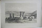
View of the Theatre at Ephesus.
 The Theatre of Claros Ephesus. "Ephesus from the Theatre of Claros." London. Dickenson & Co., Printsellers and Publishers to the Queen , 114 New Bond Street. 1847
Tinted lithograph view of the Theatre of Claros, Ephesus from Captain, the Hon. Walter Bourchier Devereux's "Views on the Shores of the Mediterranean."
The view shows the Theatre built within the cliff side above the sea, surrounded by small trees. Tinted lithograph; some light spotting mainly to blank margins, heavier to margin edges; 2 spots to centre of image amongst trees in the foreground.
Blackmer/Navari: 482; Blackmer/ Sothebey's: 549. 267 by 392mm (10½ by 15½ inches).Imagewithin border. €250
View of Telmessus.
 Tombs at Telmessus. "Rock Tombs at Telmessus." London. Dickenson & Co., Printsellers and Publishers to the Queen , 114 New Bond Street. 1847
Tinted lithograph view of the rock tombs of Telmessus from Captain, the Hon. Walter Bourchier Devereux's "Views on the Shores of the Mediterranean."Old handcolour.
The view shows the Lycian tombs built in the cliffs in the background with free standing tombs to the foreground on the valley floor, figures people the scene; a large fort stands on a rock to the right.
Telmessus was a flourishing city west of Lycia, on the Gulf of Fethiye. It was famed for its school of diviners, consulted among others by the Lydian king Croesus, prior to declaring war against Cyrus, and by Alexander the Great, when he came to the town after the siege of Halicarnassus.
Telmessos was renamed Anastasiopolis in the 8th century AD, apparently in honour of Emperor Anastasios II, but this name did not persist. The city came to be called Makri, after the name of the island at the entrance to the harbor. This name is attested for the first time in 879 AD.
The tombs date from about 400BC;the ruins are located at Fethiye. Tinted lithograph with old handcolour; clean and bright.
Blackmer/Navari: 482; Blackmer/ Sothebey's: 549. 295 by 444mm (11½ by 17½ inches).Image within the border. €300
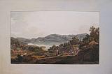
The Dinner At Crisso.
 Dinner at Crisso. "Dinner at Crisso in the house of the Bishop of Salona." London Rodwell & Martin. 1821
Aquatint view of the dinner at Crisso from the Deluxe edition of Dodwell's "Views in Greece". Original hand colour, mounted on card with title caption to verso
The view shows the interior of the house of the Bishop of Salona, where a dinner is being served with a view of the mountains from the window.
Dodwell explains the different mountains seen on either side of the Crissæan Gulf: those on the Achaian side which join the chain of Panachaikos, and the nearer hills of Ozolæa Locris, with the town of Galaxidi on the peninsular. He continues with a description of the ceremony of Washing hands, and also of the meal that is served; a dish of pilau, rice and cooked meat, the "fine kind of bread called colouri"and the fowl brought in by the Albanian woman servant. He also explains who the various people are; the Bishop being paid homage by a Greek peasant, the local priest in the black cap, and a Greek gentleman washing his hands in a bowl held by a Christian Albanian, Bright and clean.
Atabey:357;Blackmer/Navari: 493; Abbey, Travel: 130; Colas 876; Weber I: 1110. 264 by 401mm (10½ by 15¾ inches). €2000
Edward Dodwell's Superb Views in Greece.
 Views in Greece. From Drawings By Edward Dodwell, Esq. FSA &c. London Rodwell & Martin. 1821
Folio; π1 / π3 B-Q2 [ π1: Title; [π2:prospectus/ avis [ missing] ; π3: List of plates.]
30 coloured aquatint views
First edition , ordinary format on thick paper.
Very fine contemporary polished calf, armorial crest to front and back boards, triple gilt fillets on the covers, ; spine gilt; brown morroco letterpieces;
marbled end papers; all edges gilt.
From the Library of George Granville, Leveson-Gower, 1st Duke of Sutherland (1758 -1833).
George Granville Leveson Gower was the son and heir of George, 2nd Earl Gower, afterwards Marquess of Stafford, and Louisa Egerton, daughter and eventual coheir of Scroop Egerton, 1st Duke of Bridgewater. Educated at Christ Church, Oxford, where he matriculated 3 May 1775, he was created an M.A. 31 October 1777. Elected Member of Parliament for Newcastle under Lyme 1779 1784, and for Staffordshire 1787 1799, he succeeded his father as 2nd Marquess of Stafford in 1803, was made a Knight of the Garter in 1807. He was created Duke of Sutherland 28 January 1833, a matter of months before his death.
He married, 4th September 1785, Elizabeth Sutherland, Countess of Sutherland in her own right, only daughter of William, 18th Earl of Sutherland. Infamous for his rôle in the "Highland Clearances" c 1810-1820.
Some of the books in his library belonged to his son George Granville Sutherland Leveson Gower, who became 2nd Duke of Sutherland (1786 1861) known as Lord Gower during his father's lifetime.
George Granville was created Member of Parliament for St Mawes 1808 1812, for Newcastle under Lyne 1812 1815, and for Staffordshire 1815 1820, and was summoned to the House of Lords under his father's Barony of Gower in 1826. He succeeded his father in the Dukedom in 1833. The Library of the 2nd Duke was sold at auction by Sotheby, Wilkinson & Hodge on 10 March 1892.
Text / Description of each plate in English (recto) and French (verso). 30 aquatint views in Greece:
Vol.I
1. Port Bathy, and capital of Ithaca
2. Dinner at Crisso.
3. Castalian Spring.
4. Parnassus.
5. Ruins of Orchemenos.
6. Katabathron of Lake Copais.
7. View of the Parthenon from the Propylæa.
8. West Front of the Parthenon.
9. South-West View of the Erechtheion.
10. Entrance to the Tower of the Winds.
11. Dance of the Derwisches.
12. Bazar of Athens.
13. Entrance of Athens.
14. Temple of Jupiter Olympus and River Ilissos
15. Athens from Mount Arcesmus.
16. South-East view of the temple of Sunium.
17. Temple of Jupiter Panhellenios.
18. Interior of the Same Temple.
19. Monasetry of Phineromene.
Vol II.
20. Thermopylæ
21. Village of Portaria on Mount Pelion.
22. Hyperian Spring at Phere.
23. Larissa.
24. Mount Olympus.
25. Sepulchre of Hassan Baba.
26. Gate of the Lions at Mycenæ.
27. Plain of Olympia.
28. Temple of Apollo Epicurius.
29. Lake of Stymphalos.
30. Monastery of Megaspilia in Arcadia. Binding: Very fine.
Sepia aquatint vignette to title.
Lacks the Avis Π2.
List of plates. Blanks inserted between description and each plate, with off-set to verso.
Plates have title in pencil [Binders notes?]to margin, in the 1st volume most of these are to lower margin and are bound in to the gutter so barely visable, except Plate 11 Dance of the Derwisches which is portrait . in the 2nd volume Plates 20-30 the plates are bound at upper margin, and pencil ".titles" are again just visible at the gutter.
Generally bright and clean. see list below of very minor faults.
A few plates have very light spotting , a couple entering the plate:
Plate 1. Ithaca; slight indentation to margin and one in the sky.
2. Crisso; slight indentation to margin.
9. Erechteion: light soiling to margins.
12. Bazar; light soiling to margins.
14. Jupiter Olympus; finger marks to right margin.
15. Athens from Mt.Anchesmus;Light soiling ; light spot to sky, upper left.
18. Interior Aegina; Margins lightly toned; some light spotting to sky.
22. Hyperian Fountin; light spots to sky.
25. Hassan Baba; light spots to sky.
26. Lion's Gate; light spots to sky.
29. Stymphalos; crease to upperleft margin, far from plate.
30. Mega Spillia; light soiling to margins, some minor light spotting to sky.
Blackmer/Navari: 493; Atabey:357; Abbey, Travel: 130; Colas 876; Weber I: 1110. 510 by 360mm (20 by 14¼ inches). €25000
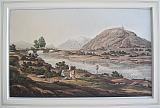
The Agora, Athens.
 Bazar of Athens "Bazar of Athens" London Rodwell & Martin. 1821
Aquatint view of the Agora or Bazar of Athens from Dodwell's "Views in Greece". Original hand colour,
The lively scene shows the weekly market of Athens where Greeks, Turks and Albanians mingle together, along with peasants and farmers from the surrounding countryside.
Dodwell gives a full description of the prominent figures portrayed, In the coffee house where a freed slave stands leaning by a tree, the proprieter brings coffee to the Disdar or Govenor of the castle, dressed in scarlet, seateds with a Turkish Agha; standingon the step is the Vaivode or Governor of Salamis, son of Spiridon Logothetis [the late English agent], he is meeting a Greek Baratario, designated by his headgear or turban [also worn by Greek physicians]; Three turkish women stand in the centre in long white robes; to the left the Turk in green is wearing the sacred colour indicating he has performed the Hajj or pilgrimmage to Mecca.
In the background, the Acropolis with the cave of Pan and the Venetian tower near the Propylea depicted to the right of the minaret; to the left the Parthenon and Erectheion. Image bright and clean; title from verso attached below image but can be covered by mount; light foxing to surrounding card.
Blackmer/Navari: 493; Atabey:357; Abbey, Travel: 130; Colas 876; Weber I: 1110. 257 by 398mm (10 by 15¾ inches). €2500
Katabathron of Lake Kopais, Bœotia.
 Katabathron of Lake Kopais. "Katabathron of Lake Kopais." London Rodwell & Martin. 1821
Aquatint view of a Katabathron of Lake Kopais from the Deluxe edition of Dodwell's "Views in Greece". Original hand colour, mounted on card with title caption to verso.
The view shows a katabothra or underground river tunnel at Lake Kopais in Bœotia.
Dodwell says in the text that the one pictured is between the ruins of Akaiphnion and the modern town of Talanda, also that such subterranean passages were known by the ancient authors Strabo, Pausanias and Pliny, the latter describing how every nine years the lake would flood and these passages allowed the water to escape; Strabo considers they may have been caused by earthquakes.
."The basin of tho Copaic lake is surrounded by mountains and like several valleys in Arcadia its waters find outlets by subterranean channels called Katabothra"[ A Handbook for Travellers in Greece: Describing the Ionian Islands ...By John Murray ] Bright and clean.
Atabey:357;Blackmer/Navari: 493; Abbey, Travel: 130; Colas 876; Weber I: 1110. 258 by 385mm (10¼ by 15¼ inches). €350
The Lake of Stymphalia Arkadia, Peloponnesus.
 Lake of Stymphalos. "Lake of Stymphalos in Arcadia." London Rodwell & Martin. 1821
Aquatint view of the Lake of Stymphalos from the Deluxe edition of Dodwell's "Views in Greece". Original hand colour, mounted on card with title caption to verso
The view shows the small lake upon whose shores can be seen vestiges of the ancient city of Stymphalos, once one of the largest towns in Arkadia, founded by Elatos son of Arkas.
Dodwell explains that the lake is fed by two streams or springs, of which the Fountain of Stymphalos at the foot of Mount Cyllene is the most noted. The waters escape from the lake by means of a katabothra or subterranean passages; the underground river emerging at Argos where it is named Erasines, finally meeting the Argolic gulf through the marshes of Lerna.
Dodwell then mentions that the lake was the site of one of the labours of Hercules the slaying of the man-eating Stymphalian birds, and comments that he obviously did his work well as there are now only ducks and common wild fowl at the lake. Bright and clean.
Atabey:357;Blackmer/Navari: 493; Abbey, Travel: 130; Colas 876; Weber I: 1110. 234 by 390mm (9¼ by 15¼ inches). €1000
Faneromeni Monastery, Salamis.
 Monastery of Phanairomene. "Monastery of Phanairomenein the Island of Salamis." London Rodwell & Martin. 1821
Aquatint view of the Monastery of Phanairomene from the Deluxe edition of Dodwell's "Views in Greece". Original hand colour, mounted on card with title caption to verso.
The view shows the monastery on the North side of the island close to the shore of the Eleusian or Megaric gulf, in the distance the mountains of Peloponnesus. The monastery is famous for the icon of the Virgin found deep below the ground where the building now stands, discovered by Lampros Kanelos (Saint Laurentios) in the 17th century leading him to rebuild the church. Bright and clean.
Atabey:357;Blackmer/Navari: 493; Abbey, Travel: 130; Colas 876; Weber I: 1110. 234 by 414mm (9¼ by 16¼ inches). €1200
The Home of the Gods, Mount Olympus, Thessaly.
 Mount Olympos. "Mount Olympos, as seen between Larissa and Baba. ." London Rodwell & Martin. 1821
Aquatint view of Mount Olympus from Dodwell's "Views in Greece". Original hand colour.
The view shows the "rugged outline...shattered in many summits" of Mount Olympus, and the course of the river Pineios across the Pierian plain, having emerged from the vale of Tempe which Dodwell writes "diffuses its charm over the space between Ossa And Olympos."
In mythology Olympus was the Home of the twelve Gods of the Greek pantheon, whilst in Pieria, the mythological tradition had placed the nine Muses patrons of the Arts, daughters of Zeus and the Mnemosyne. Bright and clean; Short tear to upper blank margin away from image.
Blackmer/Navari: 493; Atabey:357; Abbey, Travel: 130; Colas 876; Weber I: 1110. 250 by 407mm (9¾ by 16 inches). €750
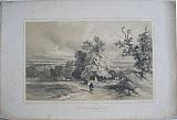
The Plain of Olympia, Elis, Peloponnesus.
 Plain of Olympia. " Plain of Olympia." London Rodwell & Martin. 1821
Aquatint view of the plain of Olympia from the Deluxe edition of Dodwell's "Views in Greece". Original hand colour, mounted on card with title caption to verso.
The view shows the course of the Alpheios river winding across the plain. Dodwell states that there is very little to be seen of the former marvels of antiquity that adorned the plain, except for the bases of a couple of columns; he goes on to encourage archeologists to follow the plan of Winkleman for excavation of the area. Bright and clean.
Atabey:357;Blackmer/Navari: 493; Abbey, Travel: 130; Colas 876; Weber I: 1110. 248 by 395mm (9¾ by 15½ inches). €750
Orchomenos, Bœotia.
 Ruins of Orchomenos. "Ruins of Orchomenos in Bœotia.". London Rodwell & Martin. 1821
Aquatint view of Orchomenos from the Deluxe edition of Dodwell's "Views in Greece". Original hand colour, mounted on card with title caption to verso
The view shows the Acropolis of Orchomenos upon an outcrop of Mount Akontios, seen from the South; the river Cephissus or Kifisos winds across the plain, with a snow covered Mount Parnassos in the background
In 1880–86, Heinrich Schliemann's excavations (H. Schliemann, Orchomenos, Leipzig 1881) revealed the tholos tomb he called the "Tomb of Minyas", a Mycenaean monument that equalled the "Tomb of Atreus" at Mycenae itself. In 1893, A. de Ridder excavated the temple of Asklepios and some burials in the Roman necropolis. In 1903–05, a Bavarian archaeological mission under Heinrich Bulle and Adolf Furtwängler conducted successful excavations at the site. Research continued in 1970–73 by the Archaeological Service under Theodore Spyropoulos, uncovering the Mycenaean palace, a prehistoric cemetery, the ancient amphitheatre, and other structures. Image bright and clean; light foxing to surrounding card away from image.
Atabey:357;Blackmer/Navari: 493; Abbey, Travel: 130; Colas 876; Weber I: 1110. 244 by 395mm (9½ by 15½ inches). €1000
Company: Bryan, Mary Louise.
Address: Ag. Andrianoy 92 , 21 100 Nafplio, Greece.
Vat No: EL 119092581