MAPS & VIEWS
PRINTS
BOOKS
Mexico and Florida, the English Territories and the Islands of the Carribean.
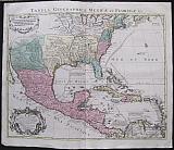 Tabula Geographica Mexicæ et Floridæ &c. Carte du Mexique et de la Floride des Teres Angloises et des Antilles. du Cours et des Environs de la Riviere de Mississsipi.
Amsterdam. Covens et Mortier Dated 1722 in cartouche
Copper engraved map of Canada from Covens & Mortier's " Nieuwe Atlas, Inhoudennde vier Gedeeltens der Waereld.. " Original full wash colour; verso blank.
Black and white strap work title cartouche and mile scale [as issued].
The map after Guillaume De l'Isle actually engraved by his father, Claude, also a cartographer.was first published in 1703 and is the first printed map to accurately depict the course, mouth and delta of the Mississippi River.
The Missouri River is also shown. Includes many sea routes across the Gulf of Mexico and between the islands.
De L'Isle drew the map from the reports brought back to France from the survivor's of the La Salle expedition into the interior of North America.
In 1682, René-Robert Cavelier, Sieur de La Salle was the first European to travel from the Great Lakes down the Mississippi River to the Gulf of Mexico.
Pierre Le Moyne d'Iberville would travel up the Mississippi to Biloxi in 1699 & 1700, On his third voyage in February 1701, he built a fort at Mobile. He left Louisiana for the last time in April 1702. His brother Jean-Baptiste Le Moyne de Bienville founded New Orleans in 1718.
De L'Isle's map also includes greater accuracy in the Great Lakes region and in its depiction of English settlements along the East Coast.
One of the most important and influential maps of the region during the early 18th Century. Dark impression; bright full wash colour; printed on heavy paper; light soiling.old red crayon numbers to verso.
Koeman I: C&M 8:114. 485 by 602mm (19 by 23¾ inches). €1500
Turcicum Imperium.
 Tabula Nova Imperii Turcarum, Arabum et Persarum. Carte de la Turquie, de l'Arabie et de la Perse.
Amsterdam. Covens et Mortier c1741
Copper engraved map of Turkey, Arabia and Persia from Covens & Mortier's " Nieuwe Atlas, Inhoudennde vier Gedeeltens der Waereld.. " Original full wash colour; verso blank.
Black and white strap work title cartouche [as issued].
The map after Guillaume De l'Isle shows the Turkish Empire, Arabia and Persia, with the surrounding countries. Dark impression; bright full wash colour; printed on heavy paper, light dampstain to upper corners; old red crayon numbers to verso.
Koeman I: C&M 8:85, [C&M 10] 498 by 577mm (19½ by 22¾ inches). €500
Nord-Pas de Calais, France.
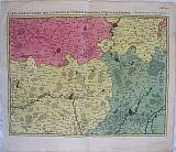 Fricx< Eugène Henry
The Environs of Cambray, Bappaumes, St Quentin, Peronne after the copy in Brussels by E.H.Freix "Carte particuliere des environs de Cambray, Bappaumes, St. Quentin, Perone ......;sur la copie de Brussel par E: H: Friex ;." Amsterdam Covens et Mortier 1745
Fricx< Eugène Henry
The Environs of Cambray, Bappaumes, St Quentin, Peronne after the copy in Brussels by E.H.Freix "Carte particuliere des environs de Cambray, Bappaumes, St. Quentin, Perone ......;sur la copie de Brussel par E: H: Friex ;." Amsterdam Covens et Mortier 1745Copper engraved map of the environs of Cambray, Bapaumes, St. Quentin and Peronne in Northern France from Covens & Mortier's " Atlas des Pays Bas,.. " Original full wash colour; verso blank.
The map appears first in Eugéne Fricx' "Tables des cartes des Pays Bas et des frontiers de France ..." published in 1712, an atlas of battles and sieges, here republished by Covens & Mortier.
The map shows the often fought over area in Northern France. at the time of the War of Succession. Dark impression; clean and bright colour; old ink number to upper right corner.
Koeman I, C&M 17, map 21: Fri1 map 21. 440 by 568mm (17¼ by 22¼ inches). €350
The Russian Empire of Peter the Great.
 The Russian Empire. Carte Générale de l'Empire de Russie.
Amsterdam. Covens et Mortier c1741
Copper engraved map on 2 sheets of the Russian Empire from Covens & Mortier's " Nieuwe Atlas, Inhoudennde vier Gedeeltens der Waereld.. " Original full wash colour; verso blank.
The large map on 2 sheets, which can be joined, shows the whole of the Russian Empire of Peter the Great, from Finland in the West to Kamchatka in the East.
Black and white copper engraved vignette to left upper corner with title on banner; black & white [as issued] strap work cartouches to lower left corner with explanation. Dark impression; bright full wash colour; printed on heavy paper, 2 sheets;Soiling to right blank margin of first map; minor paper fault (thinning) to sea, only perceptable when held to light; old red crayon numbers to verso.
Koeman I: C&M 8:90, [C&M 10] 503 by 995mm (19¾ by 39¼ inches)if joined; Left sheet: 503x495mm; Right sheet 503x500mm. €1000
The British Isles.
 Magnae Britanniae Tabula, Comprehendens Angliae, Scotiae, ac Hiberniae Regna, Ad Usum Serenissimi Burgundiae Ducis. Les Isles Brittaniques ou sont le Royaumes d'Angleterrre Tiré de Sped Celuy d'Ecosse.Tiré de TH. Pont et Celuy d'Irelandd Tiré de Petti. Le Tout Rectifié par Diverses Observations par G. de L'Isle
Amsterdam. Covens et Mortier c1741
Copper engraved map of the British Isles from Covens & Mortier's " Nieuwe Atlas, Inhoudennde vier Gedeeltens der Waereld.. " Original full wash colour; verso blank.
The map shows the British Isles, the tip of Norway and part of the coast of Europe.
Large decorative title cartouche to upper left and scale lower right
In about 1708 de L'Isle's general map of the British Isles, first produced in Paris in 1702, was copied by Pierre Mortier for publication in Amsterdam. The plate is slightly smaller and no engraver or designer's signature appears. Above the top border there is an additional Latin title: "Magnae Britanniae Tabula, Comprehendens Angliae, Scotiae, ac Hiberniae Regna, Ad Usum Serenissimi Burgundiae Ducis". The map itselff, and the decorative features, are almost identical to those by de L'Isle. Dark impression; bright full wash colour; printed on heavy paper; light toning and soiling; verso with childs crayon scribbling.
Slight crease parallel to centre fold, and occassional offset of colour
Koeman I: C&M 475 by 580mm (18¾ by 22¾ inches). €350
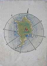
The First Printed Map Of Kea.
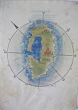 Kea. "Zea" Venice. Guilelmus Anima Mia, Tridinensis, 1485-6
Woodcut map with original handcolour of Kea from the first printed maritime atlas: Bartolomeo Dalli Sonetti's "Isolario". text to verso [ sonnet: description of Andros ]
The island within a wind rose has 2 settlements shown; the largest is the capital Ioulis where the Venetians built a castle when they recaptured the island in 1296 [It was still Venetian at the time of the "Isolario" falling to the Ottomans in 1527]. The cartography is naive and bears little relation to reality. Light dampstaining to lower part of page; ink number to upper right corner.
Zacherakis:3380/2208. 230 by 163mm (9 by 6½ inches) full page. €4000
The First Printed Map of Patmos.
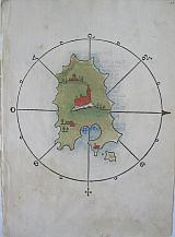 Patmos. "Pactamos." Venice. Guilelmus Anima Mia, Tridinensis, 1485-6
Woodcut map with original handcolour of Patmos from the first printed maritime atlas: Bartolomeo Dalli Sonetti's "Isolario". text to verso [ sonnet: description of Lipsos ]
The island within a wind rose has the Monastery of Saint John of the Apocalypse in the centre of the island within the town of Chora the capital. The Cave of the Apocalypse is also marked, plus 2 other settlements The cartography is naive but if seen as just the southern part of the island it makes more sense. Light dampstaining to lower part of page; ink number to upper right corner.
Zacherakis:3396/2224. 230 by 163mm (9 by 6½ inches) full page. €6000
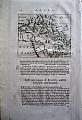
The First Printed Map of Serifos.
 Serifos. "Serphino." Venice. Guilelmus Anima Mia, Tridinensis, 1485-6
Woodcut map with original handcolour of Serifos from the first printed maritime atlas: Bartolomeo Dalli Sonetti's "Isolario". text to verso [ sonnet: description of Fermania/Kithnos ]
The island within a wind rose has the town of Chora marked in the centre. The cartography is naive. Light dampstaining to lower part of page; ink number to upper right corner.
Zacherakis:3378/2206. 230 by 163mm (9 by 6½ inches) full page. €3500
The First Printed Map Of Tilos.
 Tilos "Piscopia" Venice. Guilelmus Anima Mia, Tridinensis, 1485-6
Woodcut map with original handcolour of Tilos from the first printed maritime atlas: Bartolomeo Dalli Sonetti's "Isolario". text to verso [ sonnet: description of Nisyros ]
The island within a wind rose has 3 settlements shown. The cartography is naive. Repaired small hole to lower part of island due to oxidation of colour; light dampstaining to lower part of page and left edge; ink number to upper right corner, dampstain to the same corner; annotated with roman numerals near "A" of windrose.
Zacherakis:3370/2198. 230 by 163mm (9 by 6½ inches) full page. €2500
Smirna/ Izmir, Turkey.
 " de Golf van Smirne" Amsterdam Wolfgangh, Waesbergen, Boom. Someren en Goethals 1688
Copper engraved map ofthe gulf of Smirna/ Izmir. . Set in a page of Dutch text. [page91]
From Olfert Dapper's" Naukeurige Beschryving der Eilanden in de Archipel der Middelantsche Zee"1688. Single page, folio, text to verso. good impression. wide margins.
Zacherakis1323 123 by 162mm (4¾ by 6½ inches). €80
Agias Theodoras/ San Theodoro, Crete.
 " Eilant S. Teodoro, anders Turlulu" Amsterdam Wolfgangh, Waesbergen, Boom. Someren en Goethals 1688
Copper engraved birdseye view of the island of Agias Theoodras off Platinias in Southern Crete. Set in a page of Dutch text [page 286].
From Olfert Dapper's" Naukeurige Beschryving der Eilanden in de Archipel der Middelantsche Zee"1688. Single page, folio, text to verso. Dark impression with wide margins.
130 by 165mm (5 by 6½ inches). €80
Korinth/ Corinth, Peloponessus
 "Belephoron on Pegasus" Amsterdam Wolfgangh, Waesbergen, Boom. Someren en Goethals 1688
Copper engraved view of a relief of Belephoron on Pegasus. found at Korinth/ Corinth.
Set in a page of Dutch text [page29] from Olfert Dapper's"Naukeurige Beschryving van Morea"1688. Single page. folio. text to verso Dark impression with wide margins
130 by 164mm (5 by 6½ inches). €30
Delos, Cyclades
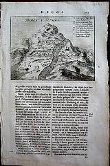 C. Decker fect 1684
"Bergh Canthus, Delos" Amsterdam Wolfgangh, Waesbergen, Boom. Someren en Goethals 1688
C. Decker fect 1684
"Bergh Canthus, Delos" Amsterdam Wolfgangh, Waesbergen, Boom. Someren en Goethals 1688Copper engraved view of the Bergh Canthus. Delos Set in a page of Dutch text [page167]
From Olfert Dapper's" Naukeurige Beschryving der Eilanden in de Archipel der Middelantsche Zee"1688. Single page; folio. Text to verso. Wide margins. Very light damp staining to lower margin
126 by 163mm (5 by 6½ inches). €30
Castle Tornese, Elis, Peloponessus.
 "Castle Tornese" Amsterdam Wolfgangh, Waesbergen, Boom. Someren en Goethals 1688
Copper engraved view of Castle Tornese, set in a page of Dutch text [ page311] from Olfert Dapper's" Naukeurige Beschryving van Morea" 1688. Single page; folio; text to verso Dark impression, wide margins.
130 by 170mm (5 by 6¾ inches). €100
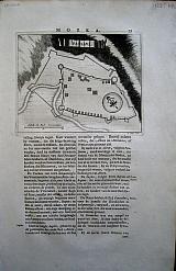
Chielafa, Laconia, Peloponessus
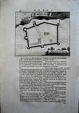 "Chielafa" Amsterdam Wolfgangh, Waesbergen, Boom. Someren en Goethals 1688
Copper engraved plan of the fort of Chielafa in Mani, set in a page of Dutch text [ page36] from Olfert Dapper's" Naukeurige Beschryving van Morea" 1688. Single page; folio; text to verso Dark impression, wide margins. page number just entering plate mark.
130 by 163mm (5 by 6½ inches). €50
Methoni/Modon, Messania, Peloponessus
 "Eylanden onder Kust van Modon" "Eilanden Sapiensa, Caprera etc" Amsterdam Wolfgangh, Waesbergen, Boom. Someren en Goethals 1688
Copper engraved map of Methoni/ Modon. set within page of text in Dutch, [page 163] folio. From Olfert Dapper's" Beschryving van Morea" 1688, showing the islands of Sapiensa. Kaloriea, Venetica and the coast of Modon. with a large galleon at the front. Good impression from a large paper copy with wide margins, text on verso.
Zacherakis 1292/876 130 by 165mm (5 by 6½ inches). €100
Garabusa, Crete
 "Garabusa" Amsterdam Wolfgangh, Waesbergen, Boom. Someren en Goethals 1688
Copper engraved birdseye view of the island of Garabusa in the Bay of Suda set in a page of Dutch text [pages249]
From Olfert Dapper's" Naukeurige Beschryving der Eilanden in de Archipel der Middelantsche Zee"1688. Single page, folio. . Good impressions with wide margins. the engraving is set above text which refers to Spinalonga as it is the next chapter heading.
Zacherakis 1317/901 128 by 159mm (5 by 6¼ inches). €120
Korinthia/Corinth, Peloponessus
 "Gulf Of Corinth" Amsterdam Wolfgangh, Waesbergen, Boom. Someren en Goethals 1688
Copper engraved map of the gulf of Corinth, set in a page of Dutch text [page16]. From Dapper's "Naukeurige Beschryving van Morea"1688. Single page; Folio; text to verso. Dark impression, wide margins.
Zacharakis 1293/877 125 by 155mm (5 by 6 inches). €150
Zante/Zakynthos, Ionian Islands.
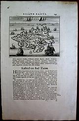 "Het Eylant Sante" Amsterdam Wolfgangh, Waesbergen, Boom. Someren en Goethals 1688
Copper engraved map. set on page of text in Dutch from Olfert Dapper's "Beschryving van Morea" 1688 Dark impression of copper engraved map with wide margins; single page; folio; within text, ; page no 149. text to verso.
Zacharakis1289/875 130 by 160mm (5 by 6¼ inches). €250
Kalogeros/ Kaloiero, Dodecanesus.
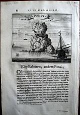 "Klip Kaloiero, anders Panaia. " "De Klip van Kaloiero" Amsterdam Wolfgangh, Waesbergen, Boom. Someren en Goethals 1688
Cpper engraved view of the Rock Kalogeros, near Nisaros. with the monastry on the peak, and a small boat being winched up from the sea. . set in a page of dutch text, [page84].
From Olfert Dapper's" Naukeurige Beschryving der Eilanden in de Archipel der Middelantsche Zee"1688. Single page, folio, text to verso. Dark impression with wide margins.
127 by 158mm (5 by 6¼ inches). €60
Mistras, Peloponnesus
 "Mistra ou Sparte" "Mistra, het gewaent Lacedemon of Sparta" Amsterdam Wolfgangh, Waesbergen, Boom. Someren en Goethals 1688
Copper engraved view of Mistras, set in a page of Dutch text [ page33] from Olfert Dapper's" Naukeurige Beschryving van Morea" 1688. Single page; folio; text to verso Dark impression, wide margins. Some foxing to the margins. also in to the printed area. Old tear 40mm long to lower blank margin
135 by 162mm (5¼ by 6½ inches). €150
Title page/Frontispiece
 "Morea en de na bygelegene Eylanden soo buyten als binnen de Golf van Venetien" "Naukeurige Beschryving van Morea Eertijts Peloponnesus. . . " Amsterdam Wolfgangh, Waesbergen, Boom. Someren en Goethals 1688
Copper engraved allegorical Frontispiece/ Title page to Olfert Dapper's"Naukeurige Beschryving van Morea"1688. depicting a coastal scene with various Gods in the foreground; Posidon, Athena, Hermes. Hercules etc. Single page; folio; Verso blank. Dark impression, wide margins. Some light foxing to margins. a little dusty and finger soiled.
270 by 170mm (10¾ by 6¾ inches). €100
Euboea/ Euboia. .
 after Marco Boschini
"Negroponte" Amsterdam Wolfgangh, Waesbergen, Boom. Someren en Goethals 1688
after Marco Boschini
"Negroponte" Amsterdam Wolfgangh, Waesbergen, Boom. Someren en Goethals 1688Copper engraved double page map of Euboea, formerly Negroponte.
From Olfert Dapper's" Naukeurige Beschryving der Eilanden in de Archipel der Middelantsche Zee"1688. Double page, folio, verso blank. Good impression. Centre fold split to lower margin [40mm ] entering printed area 20mm. Some creasing at the same point. Folded to fit folio. Margins ample.
Zacherakis 6944/444 under"Boschini" 273 by 360mm (10¾ by 14¼ inches). €400
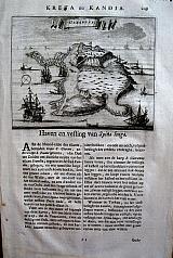
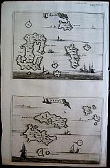
Symi, Tilos, Nisyros, Chalki & Alimia. Dodecanesus
 "Nisari", "Le Simie", "Carchi e Limonia". "Piscopia" Amsterdam Wolfgangh, Waesbergen, Boom. Someren en Goethals 1688
Copper engraved maps of Symi [and Nimos], Tilos, Nisyros, Chalki & Alimia. 4 maps on one plate.
From Olfert Dapper's" Naukeurige Beschryving der Eilanden in de Archipel der Middelantsche Zee"1688. Double page, folio, verso blank. Good impressions, wide margins. Some dust soiling. light dampstaining to lower blank margin. backed with old paper [before binding?]
Zacherakis1299/883 260 by 350mm (10¼ by 13¾ inches). €350
Passava, Mani, Peloponessus
 "Passava" Amsterdam Wolfgangh, Waesbergen, Boom. Someren en Goethals 1688
Copper engraved plan of the fort of Passava, in Mani, Laconia set in a page of Dutch text [ page39] from Olfert Dapper's" Naukeurige Beschryving van Morea" 1688. Single page; folio; text to verso Dark impression, wide margins. page number just entering plate mark.
135 by 165mm (5¼ by 6½ inches). €50
Alonissos, Sporades
 "Pelagnisi & Dromi" Amsterdam Wolfgangh, Waesbergen, Boom. Someren en Goethals 1688
2 Copper engraved maps on one page; Alonissos / Peliganisi and Dromi
From Olfert Dapper's" Naukeurige Beschryving der Eilanden in de Archipel der Middelantsche Zee"1688. Single page, folio, verso blank. Good impressions. . Lower margin short, 5mm. just touching platemark. Right margin 8-10mm.
Zacherakis 1308/892 130 by 175mm (5 by 7 inches) each map. €250
Mythology
 "Perseus rescuing Andromeda" Amsterdam Wolfgangh, Waesbergen, Boom. Someren en Goethals 1688
Copper engraved illustration of Perseus rescuing Andromeda.
Set in a page of Dutch text [page116] from Olfert Dapper's"Naukeurige Beschryving van Morea"1688. Single page. folio. text to verso Clear impression with wide margins. some soiling.
125 by 157mm (5 by 6¼ inches). €40
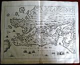
Corfu/Kerkyra, Ionian Islands
 "Pianta dell. Isola di Corfu con parte della Graecia" Amsterdam Wolfgang, Waesbergen, Boom, Someren en Goethals 1688
Double page, copper engraved map from Dapper's "Beschryving van Morea". Detailed map of the island of Corfu. also showing the coast of [modern] Albania and Epirus from Cimara to Parga. Decorative cartouche surmounted by the lion of Venice. Dark impression. wide margins. : verso blank, folio.
Zacharakis1287/873# 270 by 355mm (10¾ by 14 inches). €1200
Rethymnon, Crete.
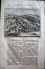 "Rethymnon" Amsterdam Wolfgangh, Waesbergen, Boom. Someren en Goethals 1688
Copper engraved birdseye view Rethymnon in Crete. Set in a page of Dutch text [page 214].
From Olfert Dapper's" Naukeurige Beschryving der Eilanden in de Archipel der Middelantsche Zee"1688. Single page, folio, text to verso. Dark impression with wide margins.
134 by 168mm (5¼ by 6½ inches). €140
Lefkada/Santa Maura, Ionian Islands
 "S. Maura" Amsterdam Wolfgangh, Waesbergen, Boom. Someren en Goethals 1688
Copper engraved map and plan, 2 images on 1 page. Above: Map of the isthmus of Lefkada/ Santa Maura; below: a detaled plan of the fort of Lefkada on the isthmus. From Olfert Dapper's "Beschryving van Morea" 1688 Dark impression with wide margins
Zacharakis 1290/ 125 by 155mm (5 by 6 inches) map. View 130x160mm. €200
Company: Bryan, Mary Louise.
Address: Ag. Andrianoy 92 , 21 100 Nafplio, Greece.
Vat No: EL 119092581