MAPS & VIEWS
PRINTS
BOOKS
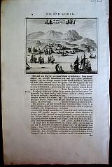
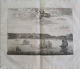
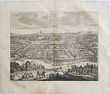
Gallipolis. Turkey.
 "Callipolis" Amsterdam Wolfgangh, Waesbergen, Boom. Someren en Goethals 1688
Copper engraved View of Gallipolis. Turkey.
From Olfert Dapper's" Naukeurige Beschryving der Eilanden in de Archipel der Middelantsche Zee"1688. Double, folio, blank verso. Dark impression. wide margins. . Slight dampstaining to lower blank margin. Hole. 5mm, at centre fold due to thinning of paper.
262 by 362mm (10¼ by 14¼ inches). €180
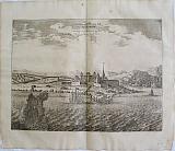
Capo Matapan, Pelopnessus.
 "Capo matapan/ Plan de Maina" Amsterdam Wolfgangh, Waesbergen, Boom. Someren en Goethals 1688
Copper engraved view of Capo Matapan and Plan of Maina in Laconia. 2 illustrations on one page. Olfert Dapper's" Naukeurige Beschryving van Morea" 1688. Single page; folio; Blank tverso Dark impression, wide margins.
135 by 165mm (5¼ by 6½ inches) view. 132x168mm plan €160
Kri Kri/ Cretan Ibex.
 "Caprus Aegagrus Creticus" Amsterdam Wolfgangh, Waesbergen, Boom. Someren en Goethals 1688
Copper engraved illustration of the Cretan Ibex or Kri kri. Set in apage of Dutch text [page 260]
From Olfert Dapper's" Naukeurige Beschryving der Eilanden in de Archipel der Middelantsche Zee"1688. Single page, folio, text to verso. Dark impression. wide margins. Slight offsetting from facing engraving.
126 by 162mm (5 by 6½ inches). €40
Corfu/ Kerkyra: Cassiope. Ionain islands
 "de Haven van Cassiope" Amsterdam Wolfgangh, Waesbergen, Boom. Someren en Goethals 1688
Copper engraved view of Cassiope in northern Kerkyra/Corfu, set on page of text, in Dutch[ page 24]. Single page, folio, Text on verso. From Olfert Dapper's" Beschryving van Morea" 1688. Dark impression. wide margins.
130 by 165mm (5 by 6½ inches). €250
Kythera/Cythera, Ionian islands
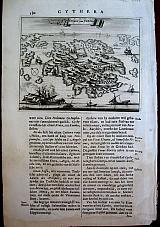 "Eylant van Cerigo" Amsterdam Wolfgangh, Waesbergen, Boom. Someren en Goethals 1688
Copper engraved map of Kythera, set in apage of Dutch text [page 180]
From Olfert Dapper's" Naukeurige Beschryving der Eilanden in de Archipel der Middelantsche Zee"1688. folio. Single page, folio, text to verso. Dark impression. good margins, light dampstaining to lower margin just touching last line of text.
Zacharakis 1314/898 130 by 165mm (5 by 6½ inches). €200
Dia, Crete.
 "Het Eilant Standia" Amsterdam Wolfgangh, Waesbergen, Boom. Someren en Goethals 1688
Copper engraved birdseye view of the island of Dia/ Standia outside Iraklion Crete. Set in a page of Dutch text [page 284].
From Olfert Dapper's" Naukeurige Beschryving der Eilanden in de Archipel der Middelantsche Zee"1688. Single page, folio, text to verso. Good impressions with wide margins. Some show through of text from verso.
125 by 157mm (5 by 6¼ inches). €120
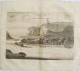
Rio Antirio, Achaia, Peloponessus.
 "Les Dardenelles de Lepanto" Amsterdam Wolfgangh, Waesbergen, Boom. Someren en Goethals 1688
Copper engraved birdseye view of the Rio Antirio/ Straights of Lepanto, at the entrance to the gulf of Corinth. Set in a page of Dutch text[page 20] from Olfert Dapper's" Naukeurige Beschryving van Morea" 1688. Single page; folio; text to verso Dark impression, wide margins. The text below over prints the plate mark but does not enter the printed area
131 by 168mm (5¼ by 6½ inches). €120
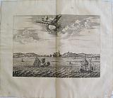
Tenedos, Turkey
 Ju. Kip. f.
"t'Casteel van Tenedos" Amsterdam Wolfgangh, Waesbergen, Boom. Someren en Goethals 1688
Ju. Kip. f.
"t'Casteel van Tenedos" Amsterdam Wolfgangh, Waesbergen, Boom. Someren en Goethals 1688Copper engraved View of the Island of Tenedos, view iof the castle.
From Olfert Dapper's" Naukeurige Beschryving der Eilanden in de Archipel der Middelantsche Zee"1688. Double, folio, blank verso. Dark impression. wide margins. 2 small ink spots to engraved area, 1 to right margin. Slight dampstaining to lower blank margin.
262 by 347mm (10¼ by 13¾ inches). €150
Algiers.
 Algiers. " De Stadt Algier La Ville D'Alger." Amsterdam Wolfgangh, Waesbergen, Boom. Someren en Goethals 1686
Copper engraved double page view of Algiers, from Olfert Dapper's "Description de l'Afrique," the first edition in French; black and white, verso blank.
The view shows the port of Algiers, with ships to the foreground. key to both upper corners in Dutch & French, identifying significant landmarks; title on decorative banner to sky. Dark impression; light toning; spotted, worse to margins, particularly upper right [ could be washed]; old ink number to upper margin.
Mendelssohn I, p.413. Cox I, p. 361; Gay 219. 265 by 357mm (10½ by 14 inches). €200
Asilah, Morocco.
 Jacob van Meurs.
Asilah. "Arzilla of Argille." Amsterdam Wolfgangh, Waesbergen, Boom. Someren en Goethals 1686
Jacob van Meurs.
Asilah. "Arzilla of Argille." Amsterdam Wolfgangh, Waesbergen, Boom. Someren en Goethals 1686Copper engraved double page view of the port of Asilah, Morocco from Olfert Dapper's "Description de l'Afrique," the first edition in French; black and white, verso blank.
The view shows the town and port of Asilah; ships to foreground.
In 1471, Asilah was occupied by the Portuguese who built the town's fortifications. It was voluntarily returned to Morocco in 1550, but was absorbed by the Spanish as they took control of Portugal in the late 16th century. In 1692 the town was recaptured by the Moroccans under the leadership of Moulay Ismail. it would later become a centre for piracy. Dark impression; light toning; some spotting mainly to blank margins; old ink number to upper margin.
Mendelssohn I, p.413. Cox I, p. 361; Gay 219. 233 by 323mm (9¼ by 12¾ inches). €150
M'Bansa or Sao Salvador, Congo/ Angola.
 Bansa or S. Salvador capital of the Congo "'Bansa ofte de stadt Salvador. Hoofdstadt van het Rijk Congo. - Bansa ou Salvador capitale de Congo" Amsterdam Wolfgangh, Waesbergen, Boom. Someren en Goethals 1686
Copper engraved double page view of Bansa or S. Salvador, capital of the Congo now in Angola, from Olfert Dapper's "Description de l'Afrique," the first edition in French; black and white, verso blank.
The plate shows a view of the city of M'Banza-Congo / Sao Salvador in Angola, formerly in the Kingdom of Congo with boats in the foreground on the river Lelunda; key to both upper corners in Dutch & French, identifying significant landmarks.
"With a population of 30,000 plus. It sat on a cliff with river below a forested valley. The King's dwelling was described as a mile and half enclosure with walled pathways, courtyard, gardens, decorated huts, and palisades" [Coguery- Vidrovitch & Catherine 2005]
The city is now is the capital of Angola's northwestern Zaire Province. It is sometimes called Mongo a Kaila (mountain of division) because of legends recalling that the king created the clans of the kingdom and sent them out from there. Dark impression; light toning;ocassional spotting; old ink number to upper margin; chips to edges at lower corners.
Mendelssohn I, p.413. Cox I, p. 361; Gay 219. 245 by 352mm (9¾ by 13¾ inches). €120
The Barbary Coast, North Africa.
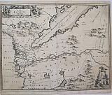
 Barbary, Libya and part of Niger. "Barbaria Biledulgerd o Libye et pars Nigritarum Terra." Amsterdam Wolfgangh, Waesbergen, Boom. Someren en Goethals 1686
Copper engraved double page map of the Barbary Caost, North Africa, from Olfert Dapper's "Description de l'Afrique," the first edition in French; black and white, verso blank.
Decorative map of the famed Barbary coast extending from Morocco to Libya. and inland showing the Sahara with some imaginary lakes.
Adorned with lions, elephants, and ostriches in the interior, ships in the sea, and a large decorative title cartouche surrounded by merchants, sailors and slaves. Dark impression; light toning; some offsetting and occasional spotting; old ink number to upper margin.
Mendelssohn I, p.413. Cox I, p. 361; Gay 219. 266 by 320mm (10½ by 12½ inches). €175
The Slave Castle Cormantin, on the Gold Coast, Ghana.
 Jacob van Meurs.
Castle Cormantin. " Kasteel van Cormantin. Chateua de Cormantin." Amsterdam Wolfgangh, Waesbergen, Boom. Someren en Goethals 1686
Jacob van Meurs.
Castle Cormantin. " Kasteel van Cormantin. Chateua de Cormantin." Amsterdam Wolfgangh, Waesbergen, Boom. Someren en Goethals 1686Copper engraved double page view of the castle of Cormantin, Ghana, from Olfert Dapper's "Description de l'Afrique," the first edition in French; black and white, verso blank.
The view shows the castle of Cormantin, on the Gold Coast, Ghana with ships to the foreground exchanging fire; title on decorative banner to sky.
The castle was built by the English between 1631 and 1645 as Fort Cormantine or Fort Courmantyne, it became the centre for British trade in gold and slaves particularly after the British capture of Jamaica in 1655 when there was a rise in demand for slave labour. Cormantin met that demand and led to slaves in Jamaica and elsewhere in the Americas becoming known as Coromantees.
The lucrative gold and slave trade attracted the attention of the Dutch who captured the castle under admiral Engel de Ruyter of the Dutch West India Company in 1665 during the Second Anglo-Dutch war. It was subsequently made part of the Dutch Gold Coast and renamed Fort Amsterdam; the fort was traded with the British in 1868. Dark impression; light toning; slight offsetting;some spotting mainly to blank margins; old ink number to upper margin.; chips to lower edges .
Mendelssohn I, p.413. Cox I, p. 361; Gay 219.; Patience Essah; "The Historical Encyclopedia of World Slavery, "Volume 1 p195 . 244 by 337mm (9½ by 13¼ inches). €120
The Portuguese Slave Castle of Elmina, on the Gold Coast, Ghana.
 Jacob van Meurs.
Castle Mina in the time of the Portuguese. "Casteel del Mina ten tyde der Portugesen. Chateau de S, George de la Mina Tesuil é toit du emps des Portugais." Amsterdam Wolfgangh, Waesbergen, Boom. Someren en Goethals 1686
Jacob van Meurs.
Castle Mina in the time of the Portuguese. "Casteel del Mina ten tyde der Portugesen. Chateau de S, George de la Mina Tesuil é toit du emps des Portugais." Amsterdam Wolfgangh, Waesbergen, Boom. Someren en Goethals 1686Copper engraved double page view of the castle of Elmina,Ghana, from Olfert Dapper's "Description de l'Afrique," the first edition in French; black and white, verso blank.
The view shows castle of Elmina on the Gold Coast, Ghana, as it looked when it was under Portuguese rule, with ships to the foreground exchanging fire; title on decorative banner to sky.
Elmina Castle was erected by Portuguese in 1482 as São Jorge da Mina (St. George of the Mine) Castle, also known simply as Mina or Feitoria da Mina) in present-day Elmina, Ghana (formerly the Gold Coast). It was the first trading post built on the Gulf of Guinea, so is the oldest European building in existence below the Sahara. First established as a trade settlement, the castle later became one of the most important stops on the route of the Atlantic slave trade.
By the seventeenth century, most trade in West Africa concentrated on the sale of slaves. São Jorge da Mina played a significant part in the Atlantic Slave Trade. The castle acted as a depot where slaves were bought in bartering fashion from local African chiefs and kings. The slaves, often captured in the African interior by the slave-catchers of coastal tribes, were sold to Portuguese traders in exchange for goods such as textiles and horses. The slaves were held captive in the castle before exiting through the castle's infamous "Door of No Return" to be transported and resold in newly colonized Brazil and other Portuguese colonies.
In 1637 the fort was taken over by the Dutch, who made it the capital of the Dutch Gold Coast. Dark impression; light toning; some spotting ,one dark to upper blank margin; old ink number to upper margin.; chips to lower edges.
Mendelssohn I, p.413. Cox I, p. 361; Gay 219. 268 by 360mm (10½ by 14¼ inches). €150
The Dutch Slave Castle at Elmina, on the Gold Coast, Ghana.
 Jacob van Meurs.
Castle Mina. "Casteel del Mina." Amsterdam Wolfgangh, Waesbergen, Boom. Someren en Goethals 1686
Jacob van Meurs.
Castle Mina. "Casteel del Mina." Amsterdam Wolfgangh, Waesbergen, Boom. Someren en Goethals 1686Copper engraved double page view of the castle of Elmina, Ghana, from Olfert Dapper's "Description de l'Afrique," the first edition in French; black and white, verso blank.
The view shows the Dutch castle of Elmina with the fort of Coenraadsburg on the Gold Coast, Ghana with ships to the foreground exchanging fire; title on decorative banner to sky.
Elmina Castle was erected by Portuguese in 1482 as São Jorge da Mina (St. George of the Mine) Castle, also known simply as Mina or Feitoria da Mina) in present-day Elmina, Ghana (formerly the Gold Coast). It was the first trading post built on the Gulf of Guinea, so is the oldest European building in existence below the Sahara. First established as a trade settlement, the castle later became one of the most important stops on the route of the Atlantic slave trade. The Dutch seized the fort from the Portuguese in 1637, and took over all the Portuguese Gold Coast in 1642. The slave trade continued under the Dutch until 1814; in 1872 the Dutch Gold Coast, including the fort, became a possession of the British Empire.
By the seventeenth century, most trade in West Africa concentrated on the sale of slaves. São Jorge da Mina played a significant part in the Atlantic Slave Trade. The castle acted as a depot where slaves were bought in bartering fashion from local African chiefs and kings. The slaves, often captured in the African interior by the slave-catchers of coastal tribes, were sold to Portuguese traders in exchange for goods such as textiles and horses.
The slaves were held captive in the castle before exiting through the castle's infamous "Door of No Return" to be transported and resold in newly colonized Brazil and other Portuguese colonies. In 1637 the fort was taken over by the Dutch, who made it the capital of the Dutch Gold Coast. During the period of Dutch control, they built a new, smaller fortress on a nearby hill to protect St. George Castle from inland attacks. This fort was called Fort Coenraadsburg. Dark impression; light toning; paper fault close to title causing small hole; some spotting ; old ink number to upper margin.; chips to lower edges.
Mendelssohn I, p.413. Cox I, p. 361; Gay 219. 225 by 332mm (8¾ by 13 inches). €150
Chios /Scio, Northern Aegean
 Chios "Eylant Scio uist Peccatio" Amsterdam Wolfgangh, Waesbergen, Boom. Someren en Goethals 1688
Copper engraved Map of the island of Chios. Set in a page of Dutch text [page 76].
From Olfert Dapper's" Naukeurige Beschryving der Eilanden in de Archipel der Middelantsche Zee"1688. Single page, folio, text to verso. Dark impression with wide margins. Paper fault 30mm to left blank margin beside the text.
Zacharakis 1320/904 120 by 161mm (4¾ by 6¼ inches). €250
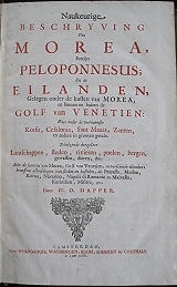
The Most Complete Description of the Archipelago.
 Description of the Islands of the Archipelago. " Naukeurige Beschryving der Eilandedn in de Archipel der Middelantsche Zee, en ontrient dezelve, gelegen: Waer onder de voornaemse Cyprus, Rhodus, Kandien, Samos,Scio, Negreponte. Lemnos, Paros, delos, Patmos en andere, in groten getale..." Amsterdam Wolfgangh, Waesbergen, Boom. Someren en Goethals 1688
Folio, pp [8] 24 + (17-92) + 84 + (33-200) + 152 + (145-150) + (143-200) + (153-320) + 40 +[4] [as published].
Despite the extremely erratic pagination and signatures, all catchwords follow and the text is complete with all the illustrations present. as published.
Engraved allegorical title; title in red and black. Dedication to Nikolas Witsen.
Large folded map of the Archipelago Zee karte van de Archipel en Arciipelsche Eylanden and 17 douple page maps and views including maps of Arcihpelago Meridionalis seu Cycladum; Insularum Archipelagi Septrionalis seu Maris Ægæ after Jacob Meurs; map of Cyprus Insula; view of Salinas/ Larnica; map of Crete; town plan of Candia/ iraklion; map of Euboea after Boschini; birdseye view of Rethymnon and a view of Chios town. 14 single page plates with views, maps and coins of the islands. 47 vignette illustrations in text [a few back to back] showing maps, views, costumes, flora, fauna and coins including views of Farmagusta and Thessalonika.
In the preface of the Description of the islands of the ArchipelagoDapper acknowledges the work of Buondelmonti, Bordone, Porcacchi, Boschini and Coronelli), contemporary travel accounts of Belon, G. Sandys, Sieur Du Loir, Spon, & Wheler and the testimonies by Dutch merchants as his sources, whilst also referring to the ancient Greek and Latin sources: Herodotus, Pausanias, Plutarch, Ptolemaeus, Strabo, Pliny the Elder, Apollonius, Hesychius, Pomponius Mela, Solinus, Stephanus Byzantius, John Chrysostom. He states that he has examined all these works to create the definitive description of the Islands and their important place in Europe, "that directs its gaze most closely towards the Orient" He praises the rich history under the Greeks Romans, Bizants and Venetiens , but laments the present desolate and deserted state of under the "heavy yoke of the Empire of the Turks" , a condition he believes and hopes will be ameliorated by the return of Christian rule. ("Mapping the Ottomans: Sovereignty, Territory, and Identity in the Early Modern Mediterranean".Palmira Brummett.Cambridge University Press)
"Dapper's work is as much a lament for the present state of Greece's past glories as it is an architectural and archaeological guide.The plate of Delos on display, with its pathetic heaps of fallen masonry, overgrown with weeds and now the home of snakes and lizards, perfectly complements the tone of the text."(Kings College London- Katie Sambrook). Contemporary blind stamped vellum over boards; red morocco label; joints cracking, starting to split at top.
Bookplate removed from front end paper. Lacks last free end paper.
Internally lightly ned with some occasional spotting throughout; Ff and Ff2 with rust spot /hole just touching a letter of text: I & I2 and z3 with lower corner torn, far from text.
Plates generally clean; good,dark impressions.
Some of the larger double page plates with narrow margins; map of Cyprus with extra fold at margins to fit binding; view of Chios printed slightly crooked therefore lower margin trimmed, Delos, lower margin trimmed; Sestos and columns of Pompey trimmed to plate mark at bottom. all plates of coins trimmed to lower margin but complete.
Atabey 323. Blackmer 453. Cobham-Jeffery 14. Contominas 190. Weber II 745. 315 by 214mm (12½ by 8½ inches). €8000
Description of the Peloponnesus and the Islands of the Adriatic.
 Description of the Morea formerly the Peloponnesus and the countries and islands of the coast of the Morea and within the gulf of Venice; Corfu, Kefalonia, Levkada and Zante... " Naukeurige Beschryving van Morea, Eertijts Pelopnnesus; en de Eilanden, Gelegen onder de kusten van Morea, en binnen en buiten de Golf de Venetien: Waer onder de voornaemmste Korfu, Cefalonia, Sant Maura, Zanten, en andere in grooten getale. Behelzende derzelver Lantschappen, steden, rivieren, poelenbergen, gewassen, dieren &c. met de karten van Morea, Golf van venetien en verschiede eilanden: benessens afbeeldingen van steden en kastelen, als Patrasso, Modon, Koron, Navarino, Napoli di Romania en Malvasia, Korinthen , Mistra &c" Amsterdam Wolfgangh, Waesbergen, Boom. Someren en Goethals 1688
2 parts in 1 volume folio,[6],1-48, 33-40,1-56,25-168 [ 255 pages as published]; [12],1-120, (105)-(116), 121-164, [176 pages as published] [6]p. {Extremely eccentric pagination throughout, nevertheless the text is complete all catchwords follow,see my note re part 2}
Engraved allegorical frontispiece, title in red & black, 2 [folding] maps, 2 [folding] views, 13 plates [7 double page], 29 illustrations in text.
Contemporary calf with gilt spine and morocco label.
First and only edition with Dutch text. Dedication to Nicolas Witsen.
The first part a description of the Peloponnesus, with double page map by Jac. Mersius and a large folding map by Joanne Blaeu; four double page views of Navarino, Modon, Coron and Nafplion; single page with 2 views of Matapan and plan of Maina, and 24 vignettes within text many after Coronelli of Patras, Korinth, Lepanto, Kalamata (3), Mistras &c
The second part :The Description of the Islands with large folding map of the Gulf of Venice, vignette views of Venice and Lesina; Description of Corfu: double page map of the island and birds-eye plan of the city; large folding view of Corfu town,: vignette view of Kasiope and 2 pages of Ancient coins. [The pagination of this chapter somewhat eccentric p21-120 and then (105)-(116); probably due to the printer having received the text after printing the following chapter?] ; chapter describing Levkada and Kefalonia : 2 single pages with 2 views on each [ plan of Isthmus of Santa Maura & Castle of Santa Maura; map & view of Kefalonia.]
Description Of Zante/ Zakinthos with large folding view and vignette map. 2 [folding] maps, 2 [folding] views, 13 plates [7 double page], 29 illustrations in text. Contemporary full calf; spine gilt. Large folding map of Morea with short margin at top[2mm],but otherwise dark impression and in good condition; double page plates with good margins.
Morea: p 472 with paper fault to blank margin[ opposite vignette of Monomvasia]; p39-473 chipping to edge worse on the last 2 pages; some spotting to gutter of pages 99-117 of Morea; acouple of dark spots on p111 effecting text.
Korfu: p29 toned and light spotting
A good copy.
Blackmer/Navari:452;Tiele, 303; Graesse II, 335. 335 by 215mm (13¼ by 8½ inches). €7500
Egypt.
 Egypt. "Nova Ægypt Tabula" Amsterdam Wolfgangh, Waesbergen, Boom. Someren en Goethals 1686
Copper engraved double page map of Egypt, from Olfert Dapper's "Description de l'Afrique," the first edition in French; black and white, verso blank.
The map is oriented with north to the left, showing the course of the Nile , with the Red Sea and Arabia in the upper part of the plate. Along the Nile various large crocodiles roam; Dapper also indicates the Pyramids.
Decorative title cartouche and scale. Dark impression; light toning; offsetting and occasional spotting; old ink number to upper margin; smudge to lower blank margin; crease to right half.
Mendelssohn I, p.413. Cox I, p. 361; Gay 219. 287 by 358mm (11¼ by 14 inches). €200
Egypt
 Egypt. "Nova Ægypti tabula." Amsterdam Jacob Meurs 1668
Copper engraved map of Egypt from Olfert Dapper's " Naukeurige Beschrijvinge der Afrikaensche Gewesten". Black & white ; verso blank
The map is oriented with north to the left, showing the course of the Nile , with the Red Sea and Arabia in the upper part of the plate. Along the Nile various large crocdiles roam; Dapper also indicates the Pyramids.
Decorative title cartouche and scale. Dark impression; toned; left and right margins extremely close.
290 by 365mm (11½ by 14¼ inches). €200
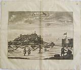
Fort Nassau, on the Island of Gorée, Senegal
 Fort Nassau, on the Island of Gorée, " Het Fort Orange en Nassou opt eiland Goree. Le Fort d'Orange et de Nassau dans lL'isle de Goree" Amsterdam Wolfgangh, Waesbergen, Boom. Someren en Goethals 1686
Copper engraved double page view of the island of Gorée, Senegal from Olfert Dapper's "Description de l'Afrique," the first edition in French;folded; black and white, verso blank. From the second part of Dapper's work the "Description des iIes de l'Afrique."
The plate shows the forts on the island of Gorée, which lies just off the port of Dakar, Senegal. Large ships exchanging fire to the foreground; banner title to sky.
Gorée is famous or infamous as being a gateway for the slave trade; it was first settled by the Portuguese then occupied by the Dutch and finally by the French from 1677 until independence in 1960. Dark impression; light toning; occasional spotting mostly to blank margins; old ink number to upper margin; chips to edges at lower corners,
Mendelssohn I, p.413. Cox I, p. 361; Gay 219. 285 by 365mm (11¼ by 14¼ inches). €150
Interior of Fort Nassau, on the Island of Gorée, Senegal
 Fort Nassauof Binien and Orange on the Island of Gorée, " Fort Nassou van Binien met Orange t' Eilant Goree. Fort Nassau dans lL'isle de Goree" Amsterdam Wolfgangh, Waesbergen, Boom. Someren en Goethals 1686
Copper engraved double page view of the island of Gorée, Senegal from Olfert Dapper's "Description de l'Afrique," the first edition in French;folded; black and white, verso blank. From the second part of Dapper's work the "Description des iIes de l'Afrique."
The plate shows the interior of Fort Nassau, built by the Dutch on the island of Gorée, which lies just off the port of Dakar, Senegal.The view is from one of the batteries with a number of canon pointing out to sea. banner title to sky.
Gorée is famous or infamous as being a gateway for the slave trade; it was first settled by the Portuguese then occupied by the Dutch and finally by the French from 1677 unti independence in 1960. Dark impression; light toning; occasional spotting mostly to blank margins; old ink number to upper margin; chips to edges at lower corners,
Mendelssohn I, p.413. Cox I, p. 361; Gay 219. 251 by 350mm (10 by 13¾ inches). €150
Guinea, West Africa.
 Guinea, West Africa. "Guinea." Amsterdam Wolfgangh, Waesbergen, Boom. Someren en Goethals 1686
Copper engraved double page map of Guinea, West Africa, from Olfert Dapper's "Description de l'Afrique," the first edition in French; black and white, verso blank.
Based on the cartography of Blaeu,the map covers the coast from Sierra Leone to Gabon. Decorative title cartouche; scale engraved on an elephant tusk born by 2 putti; lions, elephants and other wild animals to body of map and ships to sea. Dark impression; light toning; slight offsetting; occasional spotting; old ink number to upper margin.
Mendelssohn I, p.413. Cox I, p. 361; Gay 219. 264 by 362mm (10½ by 14¼ inches). €250
Jaffa, Tel Aviv, Israel
 Jaffa "Jaffa vulgo Joppen..." Amsterdam Jacob Meurs 1677
Copper engraved view of Jaffa from Olfert Dapper's " Asia...Naukeurige beschryving van gantsch Syrie, en Palestyn of Heilige Lant." Double page; black & white ; verso blank.
The view looks at the city from the sea; large ship firing a broadside in the foreground. Dark impression; lightly toned; margins trimmed close just touching image at top.
301 by 364mm (11¾ by 14¼ inches). €300
Jaffa, Tel Aviv, Israel
 Jaffa "Jaffa vulgo Joppen..." Amsterdam Jacob Meurs 1677
Copper engraved view of Jaffa from Olfert Dapper's " Asia...Naukeurige beschryving van gantsch Syrie, en Palestyn of Heilige Lant." Double page; black & white ; verso blank.
The view looks at the city from the sea; large ship firing a broadside in the foreground. Good impression; folded to fit binding; lower margin short [approx 5mm].
301 by 364mm (11¾ by 14¼ inches). €350
Larache, Morocco.
 Jacob van Meurs.
La Rache "La Rache" Amsterdam Wolfgangh, Waesbergen, Boom. Someren en Goethals 1686
Jacob van Meurs.
La Rache "La Rache" Amsterdam Wolfgangh, Waesbergen, Boom. Someren en Goethals 1686Copper engraved double page view of the port of Larache, Morocco from Olfert Dapper's "Description de l'Afrique," the first edition in French; black and white, verso blank.
The view shows the town and port of Larache; ships exchanging fire to foreground.
An important harbour town in the region Tanger-Tétouan in northern Morocco. The town was probably founded by the Banu Arous tribe. but was abandoned when the Portuguese drove out the inhabitants in 1471
Saadi Sultan Mohammed ash-Sheikh decided to repopulate it and build a stronghold on the plateau above river Loukos. He constructed a fortress at the entrance to the port as a means of controlling access to the river.
During the 15th century the Portuguese recognised it as the largest port of the area and as such unsuccessful attempts were made by the Portuguese, Spanish and French to take it. The Kasbah, which was built in 1491 by Moulay en Nasser, later became a pirate stronghold. In 1610, the town passed to the Spanish, who stayed there until 1689, but who mainly used the ports as trading stops and never really administered the town. Moulay Ismail finally recapture the city in 1689. Dark impression; light toning; some spotting mainly to blank margins; old ink number to upper margin.
Mendelssohn I, p.413. Cox I, p. 361; Gay 219. 235 by 331mm (9¼ by 13 inches). €120
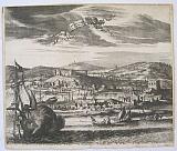
Luanda, Capital of Angola.
 Loanda S Paul. "'Loanda S Pauli" Amsterdam Wolfgangh, Waesbergen, Boom. Someren en Goethals 1686
Copper engraved large view of Luanda, capital of Angola from Olfert Dapper's "Description de l'Afrique," the first edition in French; folded; black and white, verso blank.
The large plate shows a view of the city of Luanda, formerly named São Paulo da Assunção de Loanda the capital of Angola, from the sea . with numerous ships to the foreground; key to both upper corners in Dutch & French, identifying significant landmarks. Ornate title cartouche to sky. Dark impression; light toning; occasional spotting mostly to blank margins, a few light spots to image; old ink number to upper margin.
Mendelssohn I, p.413. Cox I, p. 361; Gay 219. 280 by 498mm (11 by 19½ inches). €200
Sestos, Turkey.
 Sestos. "Sestos in Europa" Amsterdam Wolfgangh, Waesbergen, Boom. Someren en Goethals 1688
Copper engraved View of Sestos. Turkey.
From Olfert Dapper's" Naukeurige Beschryving der Eilanden in de Archipel der Middelantsche Zee"1688. Double, folio, blank verso. Dark impression. wide margins. Slight dampstaining to lower blank margin.
290 by 356mm (11½ by 14 inches). €150
Tangier, Morocco.
 Tangier. "Tanger" Amsterdam Wolfgangh, Waesbergen, Boom. Someren en Goethals 1686
Copper engraved double page view of Tangier, Morocco, from Olfert Dapper's "Description de l'Afrique," the first edition in French; black and white, verso blank.
The view shows the port of Tangier enclosed by the city walls, with ships to the foreground; the Governor's house is identified. Title on decorative banner to sky. Dark impression; light toning; occasional spotting; old ink number to upper margin.
Mendelssohn I, p.413. Cox I, p. 361; Gay 219. 245 by 317mm (9¾ by 12½ inches). €200
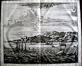
The City of Loango, Capital of the Kingdom of the same name.
 The City of Loango. " De Stadt van Lovango. Le Lovango." Amsterdam Wolfgangh, Waesbergen, Boom. Someren en Goethals 1686
Copper engraved double page view of Loango from Olfert Dapper's "Description de l'Afrique," the first edition in French; black and white, verso blank.
The view shows the city of Loango capital of the kingdom of the same name which lay in what is now the Republic of Congo, and thrived between the 15th–19th centuries.
The city is laid out before us with a key in the upper corners in Dutch & French, identifying various features including the criminal being dragged away to slavery in the foreground. Dark impression; light toning; occasional spotting; old ink number to upper margin; chips to lower edges each side.
Mendelssohn I, p.413. Cox I, p. 361; Gay 219. 267 by 334mm (10½ by 13¼ inches). €200
Company: Bryan, Mary Louise.
Address: Ag. Andrianoy 92 , 21 100 Nafplio, Greece.
Vat No: EL 119092581