MAPS & VIEWS
PRINTS
BOOKS
Samothraki, Northern Aegean.
 Delinea Fran Placentia
 Sculpsit Fran.Guianottus Mut. Samothraki "Samondrachi" Modena "Eredi Soliani stampatori Ducali" 1688
Copper engraved map of Samothraki from "L'Egeo redivivo, o' sia choragraphia dell' Archipelago". Text to verso. Good impression ; slight show through of text from verso.
Zacharakis :2676/1740 172 by 123mm (6¾ by 4¾ inches). €250
Simie, Dodecanesus.
 Delinea Fran Placentia
 Sculpsit Fran.Guianottus Mut. Simie Modena "Eredi Soliani stampatori Ducali" 1688
Copper engraved map of Simie, from "L'Egeo redivivo , o' sia choragraphia dell' Archipelago". Text to verso blank. Good impression; some slight toning to right margin; printers crease.
Zacharakis :2633/1697 170 by 120mm (6¾ by 4¾ inches). €250
Skiathos. Northern Sporades.
 Delinea Fran Placentia
 Sculpsit Fran.Guianottus Mut. Skiathos. "Cycynnethus" [Pondico] Modena "Eredi Soliani stampatori Ducali" 1688
Copper engraved map of Skiathos, called mistakenly Cynnethus or Pondico of from "L'Egeo redivivo , o' sia choragraphia dell' Archipelago". Text to verso.
. Good impression ; slight show through of text from verso.
Zacharakis :2684/1748 170 by 122mm (6¾ by 4¾ inches). €200
Skyros. Northern Sporades
 Delinea Fran Placentia
 Sculpsit Fran.Guianottus Mut. Skyros. "Schiros" Modena "Eredi Soliani stampatori Ducali" 1688
Copper engraved map of Skyros from "L'Egeo redivivo , o' sia choragraphia dell' Archipelago". Text to verso.
. Good impression ; slight show through of text from verso.
Zacharakis :2683/1747 171 by 123mm (6¾ by 4¾ inches). €200
Tenedos, Northern Aegean.
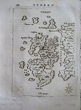 Delinea Fran Placentia
 Sculpsit Fran.Guianottus Mut. Tenedos. "Tenedo." Modena "Eredi Soliani stampatori Ducali" 1688
Copper engraved map of Tenedos from "L'Egeo redivivo, o' sia choragraphia dell' Archipelago". Text to verso. Good impression, slight show through of text from verso; faint ink blotches to lower left corner.
Zacharakis :2672/1736 172 by 123mm (6¾ by 4¾ inches). €150
Turkish Islands of the Northern Aegean.
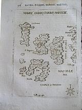 Delinea Fran Placentia
 Sculpsit Fran.Guianottus Mut. Turkish Islands. "Mavre, Oviaro, Forino, Martese." Modena "Eredi Soliani stampatori Ducali" 1688
Copper engraved map of various small Turkish islands in the Northern Aegean: Mavre, Oviaro Forino & Martese from "L'Egeo redivivo, o' sia choragraphia dell' Archipelago". Text to verso. Good impression, slight show through of text from verso.
Zacharakis :2671/1737 170 by 123mm (6¾ by 4¾ inches). €75
Ægina, Saronic Gulf.
 Delinea Fran Placentia
 Sculpsit Fran.Guianottus Mut. Ægina. "Engia." Modena "Eredi Soliani stampatori Ducali" 1688
Copper engraved map of Ægina in the Saronic Gulf. from "L'Egeo redivivo, o' sia choragraphia dell' Archipelago". Text to verso. Good impression, slight show through of text from verso.
Zacharakis :2686/1750 169 by 123mm (6¾ by 4¾ inches). €300
Astypalaia, Dodecanesus.
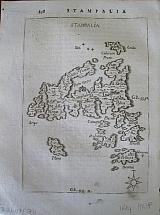 Delinea Fran Placentia
 Sculpsit Fran.Guianottus Mut. "Stampalia" Modena `"Eredi Soliani stampatori Ducali" 1688
Copper engraved map of Astypalaia and the small surrounding islands from "L'Egeo redivivo , o' sia choragraphia dell' Archipelago". Text to verso. Good impression; slight show through of text and decorative tailpiece from verso; spotting to lower right corner.
Zacharakis :2647/1711 171 by 121mm (6¾ by 4¾ inches). €250
Scarce Seventeenth Century T own Plan of Iraklion with a map of the Island of Crete.
 The Island of Candia [Crete] with Candia capital city of the Island of the same name. "Candie ville Métropolitaine de l'isle de même nom " & " Isle de Candie." Paris P du Val. " Chez l'Auteur, en l'Isle du Palais , sur Quay de l'Horologe, au coin de la rue Harlay." 1667
Copper engraved map and town plan of Crete and Iraklion, by Pierre du Val from his Atlas " Cartes De Géographie Les Plus Nouvelles Et Les Plus Fidèles." Modern colour; verso blank. 2 on 1 plate.
A scarce sheet from du Val's atlas, the upper plan showing the fortifications of the city of Iraklion; the map showing the divisions of the island with the islands of Milos, Sikinos, Folegandros, Ios, Santorini, Anafi and Astipalea, to the north. Compass rose to sea. Good impression; odd spots; dampstain to edge of upper margin; remargined to sides with paper of the same atlas; numerous folds and creases; lower map with long crease through island with some holes, backed at some time with old paper [ the description of Candia from the same atlas, but sadly with the text face down so verso blank]. Condition not perfect but acceptable for such a scarce map.
This edition not in Zacharakis [ Zacharakis:3558/2314 later edition] 510 by 390mm (20 by 15¼ inches). Candie Town:256x390mm; Island254x390mm. €600
The First English Edition of the Greek text of Pindar
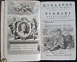 Opera. ΠΙΝΔΑΡΟΥ ΟΛΥΜΠΙΑ ΝΕΜΕΑ ΠΥΘΙΑ ΙΣΘΜΙΑ. Pindari Olympia, Nemea, Pythia, Isthmia. Una cum Latina omnium Versione Carmine Lyrico per Nicolaum Sudorium. Oxonii- Oxford E Theatro Sheldoniano 1697
Portrait, [17], pp497 (56,59-487) [42] [4] pp77 [1] Folio.
The first English edition of the Greek text edited by Richard West & Robert Welsted, fellows of Magdalen College.
Engraved portrait of Pindar by M. Burghers. facing the Title page. Dedication to the Marquess of Tavistock signed by the editors. Preface. Life of Pindar in Latin by Thomas Magister. Chronology of the Olympiads composed by the Bishop of Litchfield. Passages from various Greek Classical authors on Pindar including a fragment from Phlegon Trallianos Περί του Ολυμπιον, and notes from Suidas
Parallel Greek and Latin text, with a Latin prose paraphrase, Latin notes and scholia in Greek printed below.
After the Index is the Latin verse translation by Nicolas Le Sueur (1545-1594) Pindari Opera Omnia viz Olympia. Pythis, Nemea,& Isthmia . Latino carmine reditt per Nicolaum Sudorium in curia Parisiensis Inquisitionum Præsidem
Dibdin calls it "a beautiful and celebrated edition... on the whole, we must allow that the editors of this magnificent work have taken infinite pains to bring together every thing which could illustrate and improve the reading of the poet".
The editors compared the Mss held by the Bodleian with that of the Biblioteca Palatina. Engraved portrait of Pindar and large title page vignette by M. Burghers. Folio. full calf; gilt spine with 6 raised bands; corners slightly bumped; ex- libris to front pastedown.
Main body of text bright, crisp and clean
Prelims [ to end of table of Olympiads] and second part : Latin translation of Nicolas Le Sueur printed on slightly poorer quality paper and thus somewhat toned.
Graesse 5 p295; Brunet 4 p659; Dibdin II 289. 323 by 210mm (12¾ by 8¼ inches). €2000
ΠΛΟΥΤΑΡΧΟΥ, ΑΠΟΦΘΕΓΜΑΤΑ.
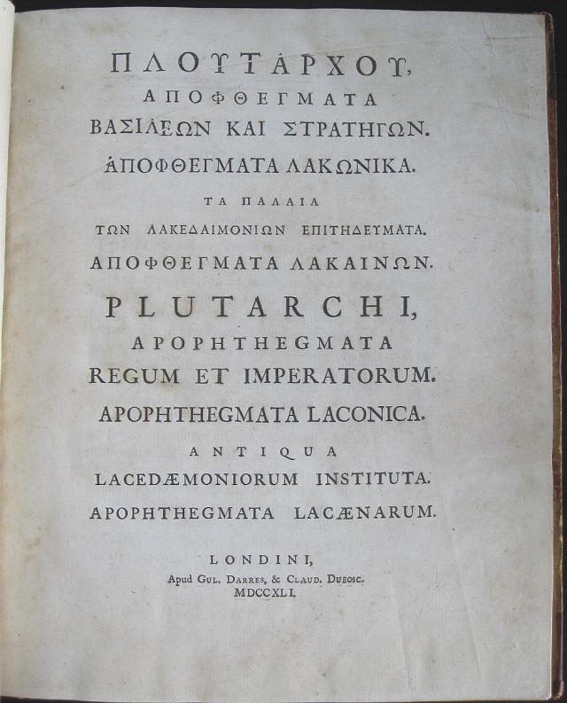 ΠΛΟΥΤΑΡΧΟΥ, ΑΠΟΦΘΕΓΜΑΤΑ ΒΑΣΙΛΕΩΝ ΚΑΙ ΣΤΡΑΤΗΓΩΝ. ΑΠΟΦΘΕΓΜΑΤΑ ΛΑΚΩΝΙΚΑ ΤΑ ΠΑΛΛΙΑ ΤΩΝ ΛΑΚΕΔΑΙΜΙΟΩΝ ΕΠΙΤΗΔΕΥΜΑΤΑ, ΑΠΟΦΘΕΓΜΑΤΑ ΛΑΚΑΙΝΩΝ.
Plutarchi Apophthegmata Regum et Imperatorum. Apophthegmata Laconica. Antiqua Lacedæmoniorum Instituta. Apophthegmata Lacænarum. Londini. Gul. Darres & Claud. Dubosc. 1741
Large Quarto: (4)+96+107 pages.
Beautifully printed edition of works attributed to Plutarch printed in London. One of the essays of the Moraliathe Apothegmataor sayings of the kings and Spartans. Half calf over marbled boards, [marbled papers torn, revealing boards]. Title, prelims and page 1 toned ; light stain to edge and gutter of pages 5/6, 7; pages 33,
96-100 with light stains.; end papers toned.
Brunet IV, 747. Graesse 5: 358. 320 by 245mm (12½ by 9¾ inches). €1200
The Editio Princeps of the First Five Books of Polybius.
 ΠΟΛΥΒΙΟΥ ΜΕΓΑΛΟΠΟΛΙΤ ΟΥ ΙΣΤΟΡΙΩΝ ΒΙ ΒΛΙΑΕ.Historiarum libri quinq[ue]. ΠΟΛΥΒΙΟΥ ΜΕΓΑΛΟΠΟΛΙΤ ΟΥ ΙΣΤΟΡΙΩΝ ΒΙ ΒΛΙΑΕ
Historiarum libri quinq , opera Vincentiii Obsopoei in lucem editi. Iidem Latini Nicolao Perotto Episcopo Sipontino Interprete. Haganoae Iohannem Secerium March 1530
[4], 106 Bl ; 142. 2°
Woodcut initials and headpieces. Titles preceded by vine-ornament Text in Greek and Latin; each part separately foliated.
Editio princeps of the first 5 books, the only fully preserved portion of Polybius's history of the rise of the Roman empire from 220 to 146 B.C.; books 6-40 survive in fragmentary form.
The revival of interest in the study of Polybius was due to Pope Nicholas V (1447-1455), the founder of the Vatican Library. Soon after his election he seems to have urged Cardinal Perotti to undertake a Latin translation of the five books then known to exist.
On the 3d of January 1454 the Pope writes again to Perotti thanking him for the third book; and in a letter to Torelli, dated 13th November 1453, Perotti says that he had finished his translation of Polybius in the preceding September. This translation was first printed in 1473. The Greek text was not printed till this edition in 1530, the first five books in Greek, along with Perotti's translation. Dedicatory epistle by Vincentii Obsopaei to George, Marquess of Brandenburg, dated October 1529.
Johannes Secerium took over the publishing house of his father in law Thomas Anshelm in 1523, the company continued until 1534.
The inscription on the title page refers to the translation of Pompilius Amasaeus Dediversis rerum publicarum formis deque Romanae praestantia of the fragments from book VI (VI3-18 and VI43- 58). Contemporary limp vellum, lacking ties. Soiling to front free endpaper
Ink inscription to first free end paper and title. old ink under linings and annotations to margins of first 25 pages including drawing of the bow of a ship lower margin p5 and battle plan in lower margin p7.
Further annotations in Greek to first pages of Latin translation.
Light dampstain to Perotti's Latin translation.
Adams P-1801,Hoffmann III, 265; Sarton I, 188. 290 by 185mm (11½ by 7¼ inches). €4500
Henry Popple's Map of the "British Empire in America" in 4 Sheets.
 A Map of the British Empire In America with the French, Spanish and the Dutch Settlements adjacent thereto by Henry Popple.
A) Nouvelle Carte Particulére de la Amerique ou sont exactement marquéese une Partie de la Baye d'Hudson, le Pays Kilistinons, la Source de la Grande Rivière de Mississipi, le Pays des Illinois &c.;
B)Nouvelle Carte Particulére de la Amerique ou sont exactement marquées la Nouvelle Bretagne, le Canada ou Nouvelle France, la Nouvelle Ecosse, la Nouvelle Angleterre, la nouvelle York, la Pensilvanie, Mary-land, la Caroline septrionale, l'Ile de terre Neuve. le Grand Banc &c.;
C)Nouvelle Carte Particulére de la Amerique ou sont exactement marquées les Provinces suivants comme la Caroline meridionale, la Floride, la Louisiane, le Mexique,le Jucatan, le Guatimala, le Darien,& une Partie de Cuba.;
D)Nouvelle Carte Particulére de la Amerique ou sont exactement marquées lesIles de Bermude, la Jamaique, Saint Domingue, les Antilles, la Terre Ferme &c. Amsterdam. Covens et Mortier c1741
Copper engraved maps[ 4 sheets] from Covens & Mortier's " Nieuwe Atlas, Inhoudennde vier Gedeeltens der Waereld.. " Original full wash colour; verso blank.
Covens and Mortier edition of Popple's map of the British Empire in America on 4 sheets. with titles in French above each map:
A) Nouvelle Carte Particulére de la Amerique ou sont exactement marquéese une Partie de la Baye d'Hudson, le Pays Kilistinons, la Source de la Grande Rivière de Mississipi, le Pays des Illinois &c.;
B)Nouvelle Carte Particulére de la Amerique ou sont exactement marquées la Nouvelle Bretagne, le Canada ou Nouvelle France, la Nouvelle Ecosse, la Nouvelle Angleterre, la nouvelle York, la Pensilvanie, Mary-land, la Caroline septrionale, l'Ile de terre Neuve. le Grand Banc &c.;
C)Nouvelle Carte Particulére de la Amerique ou sont exactement marquées les Provinces suivants comme la Caroline meridionale, la Floride, la Louisiane, le Mexique,le Jucatan, le Guatimala, le Darien,& une Partie de Cuba.;
D)Nouvelle Carte Particulére de la Amerique ou sont exactement marquées lesIles de Bermude, la Jamaique, Saint Domingue, les Antilles, la Terre Ferme &c.
Large black & white decorative title cartouche [as issued] to lower corner of sheet C
Black and white strap work cartouche [as issued] to upper corner of sheet A, containing "the Approbation of the Right Honourable the Lords Commissioners of Trade and Plantations.." and the approbation of Edmund Halley: "I have seen the abovementioned Map, which as far as I am Judge, seems to have been laid down with great Accuracy, and to shew the Position of the different Provinces & Islands in that Part of the Globe more truly than any yet extant."
Henry Popple produced this map under the auspices of the Lord Commissioners of Trade and Plantations to help settle disputes arising from the rival expansions of English, Spanish and French colonies. "France claimed not only Canada, but also territories drained by the Mississippi and its tributaries - in practical terms, an area of half a continent" (Goss The Mapping of North America p.122.)
Popple's map had quasi-official status, and a copy was sent to each of the governments of each of the colonies.
Popple's famous map on 20 sheets appeared in1733. Popple drew on many sources: the maps of Guillaume De L'Isle and Nicholas de Fer; John Barnwell's manuscript map of the south-eastern colonies of circa 1721 which included up-to-date information on the Indian settlements in the interior; and Cadwallader Colden's famous Map of the Country of the Five Nations. In all, it covers from the Grand Banks off Newfoundland to about ten degrees west of Lake Superior, and from the Great Lakes to the north coast of South America.
On the original 20 sheet map several of the sections are illustrated with pictorial insets, including views of New York City, Niagara Falls, Mexico City, and Quebec, and inset maps of Boston, Charles-Town, Providence and Bermuda. Covens and Mortier published these as seperate map sheets, [ see item 3062].
Benjamin Franklin ordered two of the original map for the Pennsylvania Assembly on 22 May 1746, "one bound and the other in sheets." One of these was hanging in the Pennsylvania State House when the Declaration of Independence was signed on July 4th, 1776. John Adams noted that Popple's map was "the largest I ever saw, and the most distinct." Copies were found in the private collections of several of the wealthier founding fathers, including George Washington. Dark impressions; bright full wash colour; printed on heavy paper; old red crayon numbers to verso.
Sheet a : tight margin to right side [approx 3mm]. Light horizontal crease to upper half visible on verso only
Sheet B: trimmed to plate mark on right side. Slight horizontal crease to upper half.
Sheet C: tight margin to right side [approx 2-4mm].
Sheet D: tight margin to right side [approx 4-6mm].
Koeman I: C&M 8:maps 107, 108, 109, 110; 610 by 535mm (24 by 21 inches) each sheet. Total size if joined approx. 1200x1070mm ( 46x 41 inches) €15000
Forts and Islands for Henry Popple's Map of the "British Empire in America"
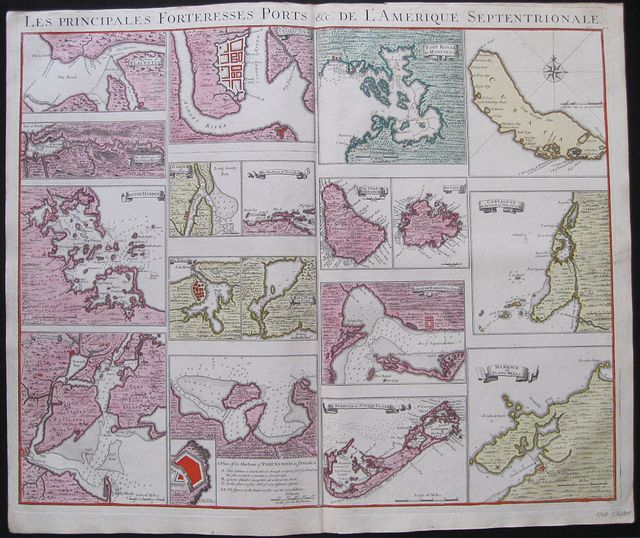 Les Principales Fortresses Ports &c de L'Amerique Septrionale.
The Harbour of Placentia; The Harbour of Anapolis Royal; Boston Harbour; New York and Perthamboy Harbours;
The Town and Harbour of Charles town in South Carolina; Harbour of St. Augustin;The Harbour of Providence; The Havana; Bay of St Iagoin Cuba; A Plan of the Harbour of Port Antonio in Jamaica.
Fort Royal in Martinica; The Island of Barbadoes; Antigua; Kingston Harbour Jamaica; Bermuda or Summer Islands;
Curacao; Carthage on the Coast of New Spain; Harbour of Porto Bello. Amsterdam. Covens et Mortier c1741
Copper engraved map sheet with 17 (18) small plans and maps of forts, harbours and Islands for Popple's Map of the British Empire in America from Covens & Mortier's Nieuwe Atlas, Inhoudennde vier Gedeeltens der Waereld..
Original full wash colour; verso blank.
Covens and Mortier published the plans and maps which could be inserted on the Popple map as a separate map sheet .
Each plan or map has its title on a banner except the island of Curacoa and the plan of Port Antonio [with inset of the fort and key]
All are 150mm wide but of varying heights. St Augustine & Providence ; Havana & St Iago; Barbadoes & Antiqua in pairs.
Each has a mile scale and the map of Curacoa includes a compass rose.
A scarce and desirable sheet Dark impressions; bright full wash colour; printed on heavy paper;upper margin trimmed to plate mark above title; old red crayon numbers to verso.
Koeman I: C&M 8:maps 111; 520 by 620mm (20½ by 24½ inches). €2200
Henry Popple's Key Map of the "British Empire in America".
 Carte Particulére de Amerique Septrionale. A Map of the British Empire In America with the French, Spanish and the Dutch Settlements adjacent thereto by Henry Popple.
Amsterdam. Covens et Mortier c1741
Copper engraved map from Covens & Mortier's " Nieuwe Atlas, Inhoudennde vier Gedeeltens der Waereld.. " Original full wash colour; verso blank.
Covens and Mortier edition of the key sheet to Popple's 20 sheet map with inset views of New York, Quebec, Mexico City and the Niagara Falls [black& white as issued] 18 coloured inset plans of ports and islands.[ see item 3062]
Black & white title cartouche as issued.
To lower right corner is the "the Approbation of the Right Honourable the Lords Commissioners of Trade and Plantations," Popple's map had quasi-official status, and a copy was sent to each of the governments of each of the colonies and the approbation of Edmund Halley: "I have seen the abovementioned Map, which as far as I am Judge, seems to have been laid down with great Accuracy, and to shew the Position of the different Provinces & Islands in that Part of the Globe more truly than any yet extant."
Popple's famous map on 20 sheets appeared 1733 Popple drew on many sources: the maps of Guillaume De L'Isle and Nicholas de Fer; John Barnwell's manuscript map of the south-eastern colonies of circa 1721 which included up-to-date information on the Indian settlements in the interior; and Cadwallader Colden's famous Map of the Country of the Five Nations. In all, it covers from the Grand Banks off Newfoundland to about ten degrees west of Lake Superior, and from the Great Lakes to the north coast of South America. Several of the sections are illustrated with pictorial insets, including views of New York City, Niagara Falls, Mexico City, and Quebec, and inset maps of Boston, Charles-Town, Providence and Bermuda.
Benjamin Franklin ordered two of the original map for the Pennsylvania Assembly on 22 May 1746, "one bound and the other in sheets." One of these was hanging in the Pennsylvania State House when the Declaration of Independence was signed on July 4th, 1776. John Adams noted that Popple's map was "the largest I ever saw, and the most distinct." Copies were found in the private collections of several of the wealthier founding fathers, including George Washington. Dark impression; bright full wash colour; printed on heavy paper; light soiling; old red crayon numbers to verso.
Koeman I: C&M 8:106; 525 by 495mm (20¾ by 19½ inches). €5000
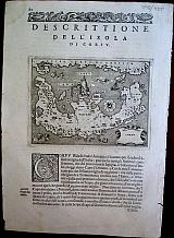
Corsica.
 Girolamo Porro.
Corsica. "Descrittione dell'Isola di Corsica." Venice Simone Galignani & Girolamo Porro. 1620
Girolamo Porro.
Corsica. "Descrittione dell'Isola di Corsica." Venice Simone Galignani & Girolamo Porro. 1620Copper engraved map of Corsica by Girolamo Porro from Porcacchi's " L'Isole piu Famose del Mondo" 1620 6th edition [ 1st 1572]. Set in a page of descriptive Italian text, with decorative woodcut headpiece and historiated initial. Single page. folio, text to verso.
Dolphins surround the island. Good impression; lightly toned.
110 by 149mm (4¼ by 5¾ inches). €200
Ireland.
 Irlanda. "Descrittione dell'Isola d'Irlanda." Venice Simone Galignani & Girolamo Porro. 1620
Copper engraved map of Ireland by Girolamo Porro from Porcacchi's " L'Isole piu Famose del Mondo" 1620 6th edition [ 1st 1572]. Set in a page of descriptive Italian text, with decorative woodcut headpiece and historiated initial. Single page. folio, text to verso.
Dolphins & monsters surround the island. Good impression; lightly toned.
110 by 150mm (4¼ by 6 inches). €250
South East Asia.
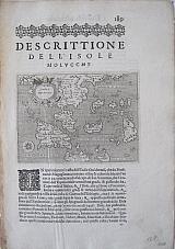 Isole Molucche. "Descrittione dell'Isola Molucche." Venice Simone Galignani & Girolamo Porro. 1620
Copper engraved map of South East Asia by Girolamo Porro from Porcacchi's " L'Isole piu Famose del Mondo" 1620 6th edition [ 1st 1572]. Set in a page of descriptive Italian text, with decorative woodcut headpiece and historiated initial. Single page. folio, text to verso.
The map shows Indochina, the Malay Peninsula and the islands of Indonesia & some of the Phillipines Good impression; lightly toned.
110 by 150mm (4¼ by 6 inches). €400
Madagascar, Africa.
 S.Lorenzo. "Descrittione dell'Isola di San Lorenzo." Venice Simone Galignani & Girolamo Porro. 1620
Copper engraved map of the island of Madagascar called "San Lorenzo" by Girolamo Porro from Porcacchi's " L'Isole piu Famose del Mondo" 1620 6th edition [ 1st 1572]. Set in a page of descriptive Italian text, with decorative woodcut headpiece and historiated initial. Single page. folio, text to verso.
Compass rose and monster to sea. Good impression; lightly toned.
110 by 150mm (4¼ by 6 inches). €150
Battle of Lepanto.
 Girolamo Porro Of Padua
" Descittione del Confletto Navale successo a'Curzolari nel Mare Ionio à vii. d'Ottobre M D LXXI. " Venice Georgio Angelieri for the Heirs of Simone Galignani 1590
Girolamo Porro Of Padua
" Descittione del Confletto Navale successo a'Curzolari nel Mare Ionio à vii. d'Ottobre M D LXXI. " Venice Georgio Angelieri for the Heirs of Simone Galignani 1590Copper engrvaed illustration of the Battle of Lepanto, by Girolamo Porro from Porcacchi's " L'Isole piu Famose del Mondo" 1590 3rd edition [ 1st 1572]. Set in a page of descripive Italian text [page 87], with decorative, woodcut headpiece and historiated initial. Single page. folio, text to verso. Fair impression, , some soiling to margins and text.
106 by 147mm (4¼ by 5¾ inches). €250
Lesbos/ Mytilene, Northern Aegean.
 Girolamo Porro Of Padua
"Metellino" Venice Simone Galignani & Girolamo Porro. 1576
Girolamo Porro Of Padua
"Metellino" Venice Simone Galignani & Girolamo Porro. 1576Copper engrvaed map of Lesbos/Mytilene. by Girolamo Porro from Porcacchi's " L'Isole piu Famose del Mondo" 1576 2nd edition [ 1st 1572]. Set in a page of descripive Italian text [page 128], with decorative, woodcut headpiece and historiated initial. Single page. folio, text to verso. Dark impression, wide margin.
Zacharakis 2740/1792 110 by 150mm (4¼ by 6 inches). €250
Euboea/Euboia.
 Girolamo Porro Of Padua
"Negroponte" Venice Simone Galignani & Girolamo Porro. 1576
Girolamo Porro Of Padua
"Negroponte" Venice Simone Galignani & Girolamo Porro. 1576Copper engrvaed map of Euboea/Eoboia, by Girolamo Porro from Porcacchi's " L'Isole piu Famose del Mondo" 1576 2nd edition [ 1st 1572]. Set in a page of descripive Italian text [page 143], with decorative, woodcut headpiece and historiated initial. Single page. folio, text to verso. Dark impression, wide margin. Light dampstaining to lower, blank, margin.
Zacharakis 2742/1794 110 by 150mm (4¼ by 6 inches). €220
Naxos, Cyclades
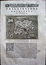 Girolamo Porro Of Padua
"Nicsia" Venice Simone Galignani & Girolamo Porro. 1576
Girolamo Porro Of Padua
"Nicsia" Venice Simone Galignani & Girolamo Porro. 1576Copper engrvaed map of Naxos, by Girolamo Porro from Porcacchi's " L'Isole piu Famose del Mondo" 1576 2nd edition [ 1st 1572]. Set in a page of descripive Italian text [page 121], with decorative, woodcut headpiece and historiated initial. Single page. folio, text to verso. Dark impression, wide margins. Printers crease to left blank margin.
Zacharakis 2738/1790 110 by 150mm (4¼ by 6 inches). €250
Karpathos, Dodecanesus.
 Girolamo Porro Of Padua
"Scarpanto" Venice Simone Galignani & Girolamo Porro. 1576
Girolamo Porro Of Padua
"Scarpanto" Venice Simone Galignani & Girolamo Porro. 1576Copper engrvaed map of Karpathos/ Scarpanto, by Girolamo Porro from Porcacchi's " L'Isole piu Famose del Mondo" 1576 2nd edition [ 1st 1572]. Set in a page of descripive Italian text [page 118], with decorative, woodcut headpiece and historiated initial. Single page. folio, text to verso. Good impression, some dampstaining to blank margins.
Zacharakis 2734/1786 110 by 150mm (4¼ by 6 inches). €200
Limnos/Stalimene, Northern Aegean.
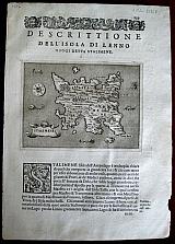 Girolamo Porro Of Padua
"Stalimene" Venice Simone Galignani & Girolamo Porro. 1576
Girolamo Porro Of Padua
"Stalimene" Venice Simone Galignani & Girolamo Porro. 1576Copper engrvaed map of Limnos, by Girolalmo Porro from Porcacchi's " L'Isole piu Famose del Mondo" 1576 2nd edition [ 1st 1572]. Set in a page of descripive Italian text [page 139], with decorative, woodcut headpiece and historiated initial. Single page. folio, text to verso. Dark impression, wide margin.
Zacharakis 2741/1793 110 by 150mm (4¼ by 6 inches). €200
Zante/ Zakynthos, Ionian Islands.
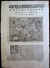 Girolamo Porro Of Padua
"Zante" Venice Simone Galignani & Girolamo Porro. 1576
Girolamo Porro Of Padua
"Zante" Venice Simone Galignani & Girolamo Porro. 1576Copper engrvaed map of Zante/ Zakynthos by Girolamo Porro from Porcacchi's " L'Isole piu Famose del Mondo" 1576 2nd edition [ 1st 1572]. Set in a page of descripive Italian text [page 98], with decorative, woodcut headpiece and historiated initial. Single page. folio, text to verso. Good impression. good margins. Minor dampstaining to upper corners of leaf.
Zacherakis 2729/1781 110 by 150mm (4¼ by 6 inches). €250
Corfu/ Kerkyra, Ionian islands
 Girolamo Porro Of Padua
Corfu. Venice Simone Galignani & Girolamo Porro. 1576
Girolamo Porro Of Padua
Corfu. Venice Simone Galignani & Girolamo Porro. 1576Copper engrved map of Corfu/ Kerkyra by Girolamo Porro from Porcacchi's " L'Isole piu Famose del Mondo" 1576 2nd edition [ 1st 1572]. Set in a page of descripive Italian text [page 82], with decorative, woodcut headpiece and historiated initial. Single page. folio, text to verso. Fair impression. good margins. Minor dampstaining to lower blank margin. and to upper corners of leaf. Worm track to lower right blank margin [7mm].
Zacherakis 2728/1780 110 by 150mm (4¼ by 6 inches). €280
Madagascar.
 Girolamo Porro Of Padua
Descrittione de L'Isole di S.Lorenzo S.Lorenzo Venice Gorgio Angeliera a instantia de gli Herede di Simone Galignani de Karera 1590
Girolamo Porro Of Padua
Descrittione de L'Isole di S.Lorenzo S.Lorenzo Venice Gorgio Angeliera a instantia de gli Herede di Simone Galignani de Karera 1590Copper engraved map of the island of of Madagascar called "San Lorenzo" by Girolamo Porro from Porcacchi's " L'Isole piu Famose del Mondo" Set in a page of descriptive Italian text [page 178], with decorative, woodcut headpiece and historiated initial. Single page. folio, text to verso.
Compass rose and monster to sea. Dark Impression; worm track to upper right blank margin.
Adams P-1906; Alden and Landis 590/54; BMC Italian, p.534; Sabin 64151. 110 by 150mm (4¼ by 6 inches). €170
Hispaniola.
 Girolamo Porro Of Padua
Descrittione de L'Isole Spagnuola Spagnuola Venice Gorgio Angeliera a instantia de gli Herede di Simone Galignani de Karera 1590
Girolamo Porro Of Padua
Descrittione de L'Isole Spagnuola Spagnuola Venice Gorgio Angeliera a instantia de gli Herede di Simone Galignani de Karera 1590Copper engraved map of the island of Hispagniola by Girolamo Porro from Porcacchi's " L'Isole piu Famose del Mondo" Set in a page of descriptive Italian text [page 165], with decorative, woodcut headpiece and historiated initial. Single page. folio, text to verso.
The map shows the island of Hispaniola present day Haiti and the Dominican Republic; numerous sea monsters Mermen and ships to sea. Dark Impression; worm track to upper left blank margin.
Adams P-1906; Alden and Landis 590/54; BMC Italian, p.534; Sabin 64151. 110 by 150mm (4¼ by 6 inches). €170
Carta Maritime, World Map.
 Girolamo Porro Of Padua
Maritime World Map Carta De Navigare Venice Gorgio Angeliera a instantia de gli Herede di Simone Galignani de Karera 1590
Girolamo Porro Of Padua
Maritime World Map Carta De Navigare Venice Gorgio Angeliera a instantia de gli Herede di Simone Galignani de Karera 1590Copper engraved maritime map of the World by Girolamo Porro from Porcacchi's " L'Isole piu Famose del Mondo" Set in a page of descriptive Italian text [page 198], with decorative, woodcut headpiece and historiated initial. Single page. folio, text to verso.
The decorative miniature sea chart is criss-crossed with rhumb lines; South America somewhat distorted; Alaska named as India Superior[ joined to Asia perhaps?]; large land mass Terra Incognitato the South. Dark Impression; light soiling to edges.
Shirley (World), 128. Sabin 64151;Adams P-1906; Alden and Landis 590/54; BMC Italian, p.534; 110 by 150mm (4¼ by 6 inches). €500
Company: Bryan, Mary Louise.
Address: Ag. Andrianoy 92 , 21 100 Nafplio, Greece.
Vat No: EL 119092581