MAPS & VIEWS
PRINTS
BOOKS
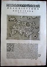
Milos, Cyclades
 Girolamo Porro Of Padua
Milo Venice Simone Galignani & Girolamo Porro. 1576
Girolamo Porro Of Padua
Milo Venice Simone Galignani & Girolamo Porro. 1576Copper engrvaed map of Milos, by Girolamo Porro from Porcacchi's " L'Isole piu Famose del Mondo" 1576 2nd edition [ 1st 1572]. Set in a page of descripive Italian text [page 121], with decorative, woodcut headpiece and historiated initial. Single page. folio, text to verso. Dark impression, wide margins. Very slight dampstaining to lower blank margin.
Zacharakis 2737/1789 110 by 150mm (4¼ by 6 inches). €200
Printer's device from Porcacchi's " L'Isole piu Famose del Mondo"
 Girolamo Porro Of Padua
Printer's Device Venice Gorgio Angeliera a instantia de gli Herede di Simone Galignani de Karera 1590
Girolamo Porro Of Padua
Printer's Device Venice Gorgio Angeliera a instantia de gli Herede di Simone Galignani de Karera 1590Copper engraved printer's device- mark from Porcacchi's " L'Isole piu Famose del Mondo" Set in a page of Italian text, with decorative, woodcut headpiece . Single page. folio, text to verso. Fair impression; some spotting worm hole lower right.
Adams P-1906; Alden and Landis 590/54; BMC Italian, p.534; Sabin 64151. 297 by 200mm (11¾ by 7¾ inches) Page. €50
Chios, Northern Aegean
 Girolamo Porro Of Padua
Scio Venice Simone Galignani & Girolamo Porro. 1576
Girolamo Porro Of Padua
Scio Venice Simone Galignani & Girolamo Porro. 1576Copper engrvaed map of Chios, by Girolamo Porro from Porcacchi's " L'Isole piu Famose del Mondo" 1576 2nd edition [ 1st 1572]. Set in a page of descripive Italian text [page 125], with decorative, woodcut headpiece and historiated initial. Single page. folio, text to verso. Dark impression, wide marginsLight dampstain to lower, blank, margin.
Zacharakis 2739/1791 110 by 150mm (4¼ by 6 inches). €250
Korinthian Gulf, and Ioanian Sea
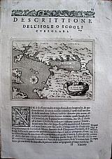 Girolamo Porro Of Padua
Site of the battle of Lepanto, the Korinthian Gulf and the Ionian Sea. "Il Sito de Curzolari" Venice Simone Galignani & Girolamo Porro. 1576
Girolamo Porro Of Padua
Site of the battle of Lepanto, the Korinthian Gulf and the Ionian Sea. "Il Sito de Curzolari" Venice Simone Galignani & Girolamo Porro. 1576Copper engrved map showing the site of the Battle of Lepanto, the Gulf of Korinth and the coast. north to Prevesa and of the Peloponesus; by Girolamo Porro from Porcacchi's " L'Isole piu Famose del Mondo" 1576 2nd edition [ 1st 1572]. Set in a page of descripive Italian text [page 85], with decorative, woodcut headpiece and historiated initial. Single page. folio, text to verso. Good impression. good margins. Minor dampstaining to upper corners of leaf.
Zacherakis 2744/1796 110 by 150mm (4¼ by 6 inches). €250
Extra Illustrated first Latin Edition of Potter's Archæologia Græca.
 Archælogia Græca. Archæologia Græca, sive veter. Græcorum, præcipue vero Atheniensium, ritus Civiles, Religiosi, Militarist et Domestica . Fusius Explicata per Joannem Potterum. Lugduni Batovorum (Leyden) Excudit Petrus Vander Aa. Biliopl. 1702
Folio; [12] 356,[14]. 9 numbered plates [1 folding]. Extra illustrated with map Graecia Sophiani by Vander Aa after Ortelius and 67 unnumbered plates, from Gronovius' Thesaurus Antiquitatum Græcarum.Title-page printed in red and black, with engraved vignette.
Printed in numbered columns 788 [but 463- 464 used twice. Jumps from column 661 to 736 (nothing missing) Collation: *6, A-Z4, Aa-Ss4, Tt usque Zz2, Aaa-Eee4.
A separate Latin edition of Potter's Archæologia Græca which also appears in Thesaurus graecarum antiquitatum / contextus & designatus ab Jacobo Gronovio; voluminis duodecimi, pars secunda. Extra illustrated with plates from elsewhere in Vander Aa's edition of the larger work
First published in English in 1697 (vol. I only) and reissued with the second volume in 1699. Includes all 9 illustrations called for.
Extra illustrated with Vander Aa's map Graecia Sophiani after Ortelius and 67 other engravings from Gronovius' Thesaurus Antiquitatum Græcarum[1697-1702] ,showing portraits of figures from ancient Greek and Roman history, and including double page engraving Deorum dearumique Capita ex Vetuustis Numismatibus collecta, effigiat, et edita e museo Abrahami Ortelii and large folding (2 double plates joined) version of Bartoli, Pietro Santo's Nova Nupta in Genarali Thalmo or The Aldobrandini Wedding a 2000 year old fresco found in Rome. Original vellum; Ex libris or "Prize" excised from front paste down.
Scattered spotting. Map: dark impression folded.
Brunet:3, 847; Graesse:5,428; Zacharakis: 49. 405 by 260mm (16 by 10¼ inches). €2800
The Continent of Europe.
 Europe. "Europa." Cologine Johann Bussemacher 1600
Copper engraved map of Europe from Mattias Quad's "Geographisch Handtbuch.." Black & white; verso blank. Dark impression; lightly toned; spot & smudges to blank margins.
182 by 265mm (7¼ by 10½ inches). €500
Lusitania
 Portugal. "Portugalia que olim Lusitania, novissima et exactissima descriptio. Auctore Vernando Aluaro Secco.." Cologine Johann Bussemacher 1596
Copper engraved map of Portugal after Vernando Aluaro Secco from Mattias Quad's "Europea totius orbis terrarum praestantissimae.." Black & white; Latin descriptive text to verso; old ink note.
The map is dated 1590 in the title cartouche. Monsters and ship to sea.; shield within the map with long desription about Aluaro beside it. Dark impression; evenly toned; ink number to upper right corner; upper centrefold split repaired
182 by 265mm (7¼ by 10½ inches). €400
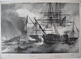
The Battle of Navarino.
 Lithograph by Hullmandel after Reinagle.
The Albion. London Colnaghi & Son, Pall Mall East January 18th 1828
Lithograph by Hullmandel after Reinagle.
The Albion. London Colnaghi & Son, Pall Mall East January 18th 1828Black & white lithograph Plate 5 from Reinagle's "Illustrations of the Battle of Navarin." Printed on india paper, mounted, verso blank.
The view focuses on the Albion:
"The Albion, Captain Ommanney, anchored within pistol shot of the Turkish line of battle ship, and a double-banked frigate; on casting anchor, she swung aboard a large frigate of 56 guns, which she boarded and carried.The Turks ran below, and fired up the hatchways, and wounded some of the men of the feet; they afterwards set fire to the ship, and her cables were scarcely disengaged when she blew up, with great part of her crew on board.
The Albion's fire was so destructive, that in half an hour she entirely disabled the Turkish liner, whose crew cut her cables and deserted her in boats; after drifting past the Azoff, this ship ran ashore with her fore top-mast stay-sail, and was burnt and blown up on Sunday.
The two line of battle ships that had engaged the Asia and Genoa drifted past the Albion toward the close of the action, and fired occasional guns as they past_ Captain C.J. Stevens killed, with 10 men, 50 wounded" Dark impression; some spotting within image ; margins cut short [5-10mm].
Blackmer/ Navari;1403 (Italian edition); Blackmer /Sotheby's: 942: Droulia :1591. 255 by 367mm (10 by 14½ inches). €700
The Battle of Navarino.
 Lithograph by Hullmandel after Reinagle.
The Asia ,ship of the line of Vice Admiral Sir Edward Codrington; "The Asia" London Colnaghi & Son, Pall Mall East January 18th 1828
Lithograph by Hullmandel after Reinagle.
The Asia ,ship of the line of Vice Admiral Sir Edward Codrington; "The Asia" London Colnaghi & Son, Pall Mall East January 18th 1828Black & white lithograph Plate 4 from Reinagle's "Illustrations of the Battle of Navarin." Printed on india paper, mounted, verso blank.
The plate focuses on the engagement between the Turkish & Egyptian Admirals and Vice Admiral Codrington on the Asia:
"The time chosen for this subject is about an hour after the commencement of the action, when the Egyptian Admiral opened his fire on the Asia. By this time the Turkish Admiral's ship was reduced to a mere wreck, the carnage on board was so immense from the well directed fire of the Asia, that there were no less than 650 turks killed _ the Asia lost 19 killed, and 57 wounded.
The Hind, tender to the Asia, the mast only of which is seen, unfortunately entangled her main boom in one of the stern portdsof Macharem Bey's ship. The Turks made strenuous efforts to board without success; the conduct of Lieut. Robb was perfectly heroic_ 4 killed, 8 wounded." Dark impression; some spotting within image ; margins cut short [5-10mm].
Blackmer/ Navari;1403 (Italian edition); Blackmer /Sotheby's: 942: Droulia :1591. 257 by 369mm (10 by 14½ inches). €700
The Battle of Navarino.
 Lithograph by Hullmandel after Reinagle.
The Genoa, Commander Bathurst "The Genoa," London Colnaghi & Son, Pall Mall East January 18th 1828
Lithograph by Hullmandel after Reinagle.
The Genoa, Commander Bathurst "The Genoa," London Colnaghi & Son, Pall Mall East January 18th 1828Black & white lithograph Plate 5he view focuses on the Genoa from Reinagle's "Illustrations of the Battle of Navarin." Printed on india paper, mounted, verso blank.
The view focuses on the Genoa:
"The Genoa (Commander Bathurst) anchored close alongside the second Turkish line of battle ship, and soon shot away her springs, by which means she was enabled to rake the Turkish ship for more than an hour. and killed 450 men; the Turkish ship caught fire in the gun room, but it was extinguished. The Capitana Bey's ship, whose cables were shot away, drifted against this ship, and suffered considerably from the raking fire of the Genoa; they both drifted past the Albion at four o'clock, and re-anchored close astern of her; the Genoa and Albion's guns sunk a double-banked frigate which is represented floundering." Dark impression; some spotting within image ; margins cut short [5-10mm].
Blackmer/ Navari;1403 (Italian edition); Blackmer /Sotheby's: 942: Droulia :1591. 265 by 367mm (10½ by 14½ inches). €700
The Battle of Navarino.
 Lithograph by Hullmandel after Reinagle.
The Scipion. "The Scipion anchored by the Stern and the Dartmouth raking the Turkish line" London Colnaghi & Son, Pall Mall East January 18th 1828
Lithograph by Hullmandel after Reinagle.
The Scipion. "The Scipion anchored by the Stern and the Dartmouth raking the Turkish line" London Colnaghi & Son, Pall Mall East January 18th 1828Black & white lithograph Plate 2 from Reinagle's "Illustrations of the Battle of Navarin." Printed on india paper, mounted, verso blank.
The plate focuses on the Scipion:
"The Scipion on entering the harbour ran aboard one of the Brulots and entangled her bowsprit with the rigging of the Brulot's fore and main masts She is represented as just having anchored by the stern; the flames from the fire brig ran in at the bow ports and exploded the cartridges in the men's hands; three times the fire caught several parts of the ship, and nine of her men died of the burns they received in disengaging her bowsprit.
Capt. Sir Thomas Fellowes (of the Dartmouth) sent a boat to her assistance, which, together with one from the Rose, and one from the Philomel, succeeded in towing the Brulot from under her bows _ 2 killed, 36 wounded.
The gallant commander of the Dartmouth anchored in such a position, as to rake the Turkish line; her fore and mizen top-gallant sails were burnt, and she narrowly escaped catching fire from a Brulot, that drifted on her starboard quarter, near enough to be boomed off.
The Dartmouth sunk some small vessels close to the town early in the action. Captain Davies of the rose behaved with great personal bravery, and actually had hold of the main chains of the fire brig( in the act of boarding her) when she blew up.
The Rose afterwards made sail to the assistance of the Armide, and resolutely cast anchor within pistol shot of two Turkish corvettes _ 3 killed, 15 wounde.
Mount Temathia is seen in the background."
Dark impression; some spotting within image ; margins cut short [5-10mm].
Blackmer/ Navari;1403 (Italian edition); Blackmer /Sotheby's: 942: Droulia :1591. 256 by 365mm (10 by 14¼ inches). €700
The Battle of Navarino.
 Lithograph by Hullmandel after Reinagle.
The Town of New Navarino "The Town of New Navarino with La Provence .... 2 days after the Battle." London Colnaghi & Son, Pall Mall East January 18th 1828
Lithograph by Hullmandel after Reinagle.
The Town of New Navarino "The Town of New Navarino with La Provence .... 2 days after the Battle." London Colnaghi & Son, Pall Mall East January 18th 1828Black & white lithograph Plate 13 from Reinagle's "Illustrations of the Battle of Navarin." Printed on india paper, mounted, verso blank.
View of the town and castle of New Navarino, 2 days after the Battle:
"The town of Navarino stands on a promomtory at the foot of Mount Tamathia, it extends a quarter league in length from east to west, but is much less in width; the fortifications were built in 1572, and were never repaired until the war with the Russians in 1770. The town is surrounded by a wall without ditches, outworks, or rampartsand the artillery consists of about forty iron guns.
Navarin surrendered to the Turks on 23rd May 1825." Dark impression; some light spotting within image ; margins cut short [2-6mm].
Blackmer/ Navari;1403 (Italian edition); Blackmer /Sotheby's: 942: Droulia :1591. 250 by 365mm (9¾ by 14¼ inches). €700
The Ruins of Ephesus, Turkey.
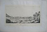 Ruins of Ephesus form the Theatre towards the swamp crossed by the Caystre "Ruines d'Ephese _ Vue prise de l'hémicyle du Théâtre,direction du couchant, marais traversés par le Caÿstre. 23 November1843" Lyon Typographie de Louis Perrin...Claude Bonavait 1867
Black and white lithograph of Ephesus from Etienne Rey's "Voyage Pittoresque en Grece et dans le Levant Fait en 1843-1844.." printed on india paperwith monogram of Rey in plate; First and only edition.
With key identifying the prison of St Paul; the aquaduct, etc.. Some foxing, spotting to plate.
Blackmer/Navari:1412; Blackmer/ Sotheby's:1436 215 by 368mm (8½ by 14½ inches). €150
Panorama from Kungsholmen of Stockholm.
 Kingsholmer bridge Stockholm " Kõnigsholmer Brücke. zu Stockholm in Schweden." Augsburg? Richter, Joh August c1750
Copper engraved panoramic view Stockholm over the Kõnigsholmer bridge,by Johann August Richter. Black & white as published.
The major buildings are identified in the key at lower right.
Poseidon in the foreground pointing down at the city. The view is in the style of Bodenehr including the banner title and Poseidon looking down on the city Fair impression; folded with some extra creases.; repaired tear to upper blank margin.
176 by 550mm (7 by 21¾ inches). €500
British Isles.
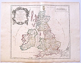 British Isles. "Britannicae Insulae in quibus Albion seu Britannia Major, et Ivernia seu Britannia Minor.." Paris Robert de Vaugondy filio 1750
Copper engraved map of the British Isles engraved by Guillaume de la Haye for Didier, Robert de Vaugondy from the "Atlas Universel.".Original outline colour; verso blank.
Black and white strapwork cartouche
Vaugondy's map of Roman Britain, which follows the map by Nicolas Sanson. Dark impression; toned and with scattered spottin; some offset of outline colour.
Pedley, Bel et Utile: the Work of the Robert de Vaugondy Family of Mapmakers, 46 (6). 495 by 555mm (19½ by 21¾ inches). €160
Constaninople, Turkey.
 Franco, Giacomo.
"Constantinopoli" Venice Giacomo Franco or M Sadeler 1598-1610
Franco, Giacomo.
"Constantinopoli" Venice Giacomo Franco or M Sadeler 1598-1610Copper engraved birdseye view of Constantinople from "Viaggio da Venetia, a Constantinopli per mare, e perterra, & insieme di Terra Santa. " edition without headings, blank to verso. Dark impression; wide margins.
Blackmer. Navari 1447. 98 by 177mm (3¾ by 7 inches). €500
Chalkis/ Chalkida, Euboea.
 Franco, Giacomo.
Chalkis. Negroponte. Venice Giacomo Franco or M Sadeler 1598-1610
Franco, Giacomo.
Chalkis. Negroponte. Venice Giacomo Franco or M Sadeler 1598-1610Copper engraved birds eye view/ plan of Chalkis, Euboea from "Viaggio da Venetia, a Constantinopli per mare, e perterra, & insieme di Terra Santa." Italian text to verso , with historiated capital. Desription of succeeding map: Tinos.
The heading title "A Constanopoli." above map; page number 64; plate number 58. Dark impression; wide margins. Lightly toned, fingermarks to margins.
Navari 1447. 100 by 175mm (4 by 7 inches). €350
Euboea.
 Franco, Giacomo.
Euboea. Negroponte. Venice Giacomo Franco or M Sadeler 1598-1610
Franco, Giacomo.
Euboea. Negroponte. Venice Giacomo Franco or M Sadeler 1598-1610Copper engraved map of Euboea from "Viaggio da Venetia, a Constantinopli per mare, e perterra, & insieme di Terra Santa." Italian text to verso , with historiated capital.
The heading title "A Constanopoli." above map; page number 63; plate number 51. Dark impression; wide margins. Lightly toned, fingermarks to margins.
Zacharakis:2965/1947;Blackmer. Navari 1447. 102 by 176mm (4 by 7 inches). €450
Ikaria , Dodecanesus.
 Franco, Giacomo.
Ikaria. Nicaria Venice Giacomo Franco or M Sadeler 1598-1610
Franco, Giacomo.
Ikaria. Nicaria Venice Giacomo Franco or M Sadeler 1598-1610Copper engraved map of Ikaria from "Viaggio da Venetia, a Constantinopli per mare, e perterra, & insieme di Terra Santa." Italian text to verso with historiated capital;description of the succeeding map: Samos;
The heading title "A Constanopoli." above map; page number 67; plate number 61. Dark impression; wide margins. Map printed slightly crooked on page; lightly toned, fingermarks to margins.
Zacharakis:2968/1950;Blackmer. Navari 1447. 103 by 172mm (4 by 6¾ inches). €350
Karpathos, Dodecanesus.
 Franco, Giacomo.
Karpathos. Scharpanto Venice Giacomo Franco or M Sadeler 1598-1610
Franco, Giacomo.
Karpathos. Scharpanto Venice Giacomo Franco or M Sadeler 1598-1610Copper engraved map of Karpathos from "Viaggio da Venetia, a Constantinopli per mare, e perterra, & insieme di Terra Santa." Italian text to verso with historiated capital; description of the succeeding map: Crete;
The heading title "A Constanopoli." above map; page numbernot printed but 47 ; plate number 47. Dark impression; wide margins. Map printed slightly crooked on page;lightly toned, fingermarks to margins.
Zacharakis:2953/1935;Blackmer. Navari 1447. 100 by 178mm (4 by 7 inches). €350
Kos, Dodecanesus.
 Franco, Giacomo.
Kos. Lango. Venice Giacomo Franco or M Sadeler 1598-1610
Franco, Giacomo.
Kos. Lango. Venice Giacomo Franco or M Sadeler 1598-1610Copper engraved map of Kos from "Viaggio da Venetia, a Constantinopli per mare, e perterra, & insieme di Terra Santa." Italian text to verso , with historiated capital.
The heading title "A Constanopoli." above map; page number58; plate number 51, signature P2 Good impression; wide margins. Map printed slightly crooked on page; lightly toned, fingermarks to margins.
Zacharakis:2958/1940;Blackmer. Navari 1447. 102 by 172mm (4 by 6¾ inches). €400
Lesbos./ Mytilene.
 Franco, Giacomo.
Lesbos. Metileme. Venice Giacomo Franco or M Sadeler 1598-1610
Franco, Giacomo.
Lesbos. Metileme. Venice Giacomo Franco or M Sadeler 1598-1610Copper engraved map of Lesbos/ Mytilene from "Viaggio da Venetia, a Constantinopli per mare, e perterra, & insieme di Terra Santa." Italian text to verso , with historiated capital; description of the succeeding map: Milos.
The heading title "A Constanopoli." above map; page number 70; plate number 65. Dark impression; wide margins; lightly toned; water stain to upper margin; ink stain tto right margin; fingermarks to margins.
Zacharakis:2972/1954;Blackmer. Navari 1447. 100 by 176mm (4 by 7 inches). €350
Levkada, Ionian islands, and the Gulf of Prevesa.
 Franco, Giacomo.
Levkada and the Gulf of Prevesa. Santa Maura Venice Giacomo Franco or M Sadeler 1598-1610
Franco, Giacomo.
Levkada and the Gulf of Prevesa. Santa Maura Venice Giacomo Franco or M Sadeler 1598-1610Copper engraved map of Levkada and the gulf of Prevesae from "Viaggio da Venetia, a Constantinopli per mare, e perterra, & insieme di Terra Santa." Italian text to verso , with historiated capital.
The heading title "A Constanopoli." above map; page number 70; plate number 65. Dark impression; wide margins; lightly toned; water stain to upper margin; ink stain tto right margin; fingermarks to margins.
Zacharakis:2947/1929;Blackmer. Navari 1447. 100 by 176mm (4 by 7 inches). €300
Milos, Cyclades.
 Franco, Giacomo.
Milos. "Millo" Venice Giacomo Franco or M Sadeler 1598-1610
Franco, Giacomo.
Milos. "Millo" Venice Giacomo Franco or M Sadeler 1598-1610Copper engraved map of Milos from "Viaggio da Venetia, a Constantinopli per mare, e perterra, & insieme di Terra Santa." text to verso; modern hand colour.
The heading title "A Constanopoli." above map; page number 61; plate number54; signature Q. Dark impression; wide margins.
Zacharakis:2962/1944;Blackmer. Navari 1447. 100 by 175mm (4 by 7 inches). €400
Sea Battle off Methoni, Coast ofPeloponnesus.
 Franco, Giacomo.
Modon, Navarino. Venice Giacomo Franco or M Sadeler 1598-1610
Franco, Giacomo.
Modon, Navarino. Venice Giacomo Franco or M Sadeler 1598-1610Copper engraved map/plan of a sea battle off Methoni and the coast of the Peloponnesus, as far as Navarino/ Pylos from "Viaggio da Venetia, a Constantinopli per mare, e perterra, & insieme di Terra Santa." Italian text to verso , with historiated capital.
The heading title "A Constanopoli." above map; page number 41; plate number 37; signature:L. Dark impression; wide margins; lightly toned; fingermarks to margins.
Navari 1447. 100 by 175mm (4 by 7 inches). €400
Naxos, Cyclades.
 Franco, Giacomo.
Naxos. Nicsia. Venice Giacomo Franco or M Sadeler 1598-1610
Franco, Giacomo.
Naxos. Nicsia. Venice Giacomo Franco or M Sadeler 1598-1610Copper engraved map of Naxos from "Viaggio da Venetia, a Constantinopli per mare, e perterra, & insieme di Terra Santa." Italian text to verso , with historiated capital; description of the succeeding map: Milos.
The heading title "A Constanopoli." above map; page number 60; plate number 53. Good impression; wide margins; lightly toned, fingermarks to margins.
Zacharakis:2960/1942;Blackmer. Navari 1447. 100 by 175mm (4 by 7 inches). €450
Patmos, Dodecanesus.
 Franco, Giacomo.
Patmos. "Palmosa" Venice Giacomo Franco or M Sadeler 1598-1610
Franco, Giacomo.
Patmos. "Palmosa" Venice Giacomo Franco or M Sadeler 1598-1610Copper engraved map of Patmos from "Viaggio da Venetia, a Constantinopli per mare, e perterra, & insieme di Terra Santa." Italian text to verso with historiated capital; description of the succeeding map: Ikaria;
The heading title "A Constanopoli." above map; page number 66; plate number 60; signature R2. Dark impression; wide margins. Map printed slightly crooked on page; lightly toned, fingermarks to margins.
Zacharakis:2974/1956;Blackmer. Navari 1447. 100 by 175mm (4 by 7 inches). €450
Samos.
 Franco, Giacomo.
Samos. Samo. Venice Giacomo Franco or M Sadeler 1598-1610
Franco, Giacomo.
Samos. Samo. Venice Giacomo Franco or M Sadeler 1598-1610Copper engraved map of Samoss from "Viaggio da Venetia, a Constantinopli per mare, e perterra, & insieme di Terra Santa." Italian text to verso , with historiated capital; description of the succeeding map: Milos.
The heading title "A Constanopoli." above map; page number 68; plate number 62. Dark impression; wide margins; lightly toned, fingermarks to margins.
Zacharakis:2967/1949;Blackmer. Navari 1447. 100 by 175mm (4 by 7 inches). €450
Tinos, Cyclades.
 Franco, Giacomo.
Tinos. Tine. Venice Giacomo Franco or M Sadeler 1598-1610
Franco, Giacomo.
Tinos. Tine. Venice Giacomo Franco or M Sadeler 1598-1610Copper engraved map of Tinos from "Viaggio da Venetia, a Constantinopli per mare, e perterra, & insieme di Terra Santa." Italian text to verso , with historiated capital; description of the succeeding map: Milos.
The heading title "A Constanopoli." above map; page number 65; plate number 59; signature: R. Good impression; wide margins; lightly toned, fingermarks to margins.
Zacharakis:2966/1948;Blackmer. Navari 1447. 100 by 175mm (4 by 7 inches). €400
Marmarica, North Africa.
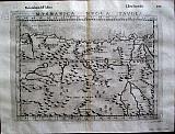 Gioseffo Rosaccio, after Giacomo Gastaldi.
"Marmaica Nuova Tavola. " Venice Hereredi di Melchior Sessa. 1598-99
Gioseffo Rosaccio, after Giacomo Gastaldi.
"Marmaica Nuova Tavola. " Venice Hereredi di Melchior Sessa. 1598-99Copper engraved map of "Marmarica", part of north Africa between Cyrene and the Nile, from the 4th edition of Ruscelli's " Geografio di Claudio Tolemeo, Alessandrio. . ", edited and augmented by Rosaccio. Italian text to verso. 4to. Dark impression; some show through of text from verso; 2 small paper flaws to engraved area.
Sabin:66507 190 by 262mm (7½ by 10¼ inches). €130
Company: Bryan, Mary Louise.
Address: Ag. Andrianoy 92 , 21 100 Nafplio, Greece.
Vat No: EL 119092581