MAPS & VIEWS
PRINTS
BOOKS
Istria.
 Istria. Istria sub Dominium Venetorum. Nuremberg. Sandrardt Jacob. 1686
Copper engraved miniature map of the Venetian possesions in Italy , from Sandrart's: Kurtze Beschreibung Von Dem Ursprung/ Aufnehmen/ Gebiete/ und Regierung der Weltberühmten Republick Venedig/ Mehrentheils den Jahren nach/ und in Form einer kurtzen Chronick verabfasset/ Wie auch eine kurtze Beschreibung der vornehmsten Griechischen Provintz und Pen-Insel Morea.
[Description of the origin/absorption/territories/and government of the world-famous Republic of Venice/mostly over the years/and written in the form of a short chronicle/as well as a short description of the most distinguished Greek province and pen island of Morea.]
Black and white, verso blank. Folded ,[2 vertical folds].
112 by 140mm (4½ by 5½ inches). €150
The Island of Korcula off the Dalmatian Coast of Croatia.
 Korcula Curzola Nuremberg. Sandrardt Jacob. 1686
Copper engraved miniature map of the island of Korcula off the Dalmatian coast of Croatia from Sandrart's: Kurtze Beschreibung Von Dem Ursprung/ Aufnehmen/ Gebiete/ und Regierung der Weltberühmten Republick Venedig/ Mehrentheils den Jahren nach/ und in Form einer kurtzen Chronick verabfasset/ Wie auch eine kurtze Beschreibung der vornehmsten Griechischen Provintz und Pen-Insel Morea.
[Description of the origin/absorption/territories/and government of the world-famous Republic of Venice/mostly over the years/and written in the form of a short chronicle/as well as a short description of the most distinguished Greek province and pen island of Morea.]
Black and white, verso blank.
The map shows the city of Split/ Spallato with the fortress of Klis/Clissa behind Folded; Light toning.
Lower margin trimmed close to printed line
70 by 114mm (2¾ by 4½ inches). €80
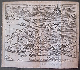
Padua.
 Padua. Padova. Nuremberg. Sandrardt Jacob. 1686
Copper engraved miniature bird's eye view ofPadua, from Sandrart's: Kurtze Beschreibung Von Dem Ursprung/ Aufnehmen/ Gebiete/ und Regierung der Weltberühmten Republick Venedig/ Mehrentheils den Jahren nach/ und in Form einer kurtzen Chronick verabfasset/ Wie auch eine kurtze Beschreibung der vornehmsten Griechischen Provintz und Pen-Insel Morea.
[Description of the origin/absorption/territories/and government of the world-famous Republic of Venice/mostly over the years/and written in the form of a short chronicle/as well as a short description of the most distinguished Greek province and pen island of Morea.]
Black and white, verso blank.
The plan appears to be a miniature version of the Braun and Hogenberg view of 1617.in which most striking feature of this view of Padua from the west is the city wall and moat, built by the Venetians in 1509; with small inset view of a lock on the river Brenta. Folded ,[2 vertical folds].
113 by 140mm (4½ by 5½ inches). €150
Palmanova, Italy.
 Palmanova Palma Nuremberg. Sandrardt Jacob. 1686
Copper engraved miniatureplan of Palmanova in N.E.Italy , from Sandrart's: Kurtze Beschreibung Von Dem Ursprung/ Aufnehmen/ Gebiete/ und Regierung der Weltberühmten Republick Venedig/ Mehrentheils den Jahren nach/ und in Form einer kurtzen Chronick verabfasset/ Wie auch eine kurtze Beschreibung der vornehmsten Griechischen Provintz und Pen-Insel Morea.
[Description of the origin/absorption/territories/and government of the world-famous Republic of Venice/mostly over the years/and written in the form of a short chronicle/as well as a short description of the most distinguished Greek province and pen island of Morea.]
Black and white, verso blank. Light toning, small spot to right; lower margin short.
68 by 112mm (2¾ by 4½ inches). €70
Sibenik, on the Dalmatian Coast of Croatia.
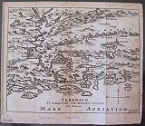 Sibenik, Dalmatian coast. Sebenico Nuremberg. Sandrardt Jacob. 1686
Copper engraved miniature map of Sibeinik on the Dalmatian coast of Croatia from Sandrart's: Kurtze Beschreibung Von Dem Ursprung/ Aufnehmen/ Gebiete/ und Regierung der Weltberühmten Republick Venedig/ Mehrentheils den Jahren nach/ und in Form einer kurtzen Chronick verabfasset/ Wie auch eine kurtze Beschreibung der vornehmsten Griechischen Provintz und Pen-Insel Morea.
[Description of the origin/absorption/territories/and government of the world-famous Republic of Venice/mostly over the years/and written in the form of a short chronicle/as well as a short description of the most distinguished Greek province and pen island of Morea.]
Black and white, verso blank. Folded; Light toning.
112 by 140mm (4½ by 5½ inches). €150
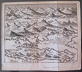
Spllit, on the Dalmatian Coast of Croatia.
 Split, Dalmatian coast. Spallato Nuremberg. Sandrardt Jacob. 1686
Copper engraved miniature map of Split on the Dalmatian coast of Croatia from Sandrart's: Kurtze Beschreibung Von Dem Ursprung/ Aufnehmen/ Gebiete/ und Regierung der Weltberühmten Republick Venedig/ Mehrentheils den Jahren nach/ und in Form einer kurtzen Chronick verabfasset/ Wie auch eine kurtze Beschreibung der vornehmsten Griechischen Provintz und Pen-Insel Morea.
[Description of the origin/absorption/territories/and government of the world-famous Republic of Venice/mostly over the years/and written in the form of a short chronicle/as well as a short description of the most distinguished Greek province and pen island of Morea.]
Black and white, verso blank.
The map shows the city of Split/ Spallato with the fortress of Klis/Clissa behind Folded; Light toning.
113 by 140mm (4½ by 5½ inches). €150
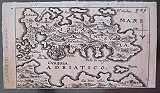
Trogir, and the Island of Bua Dalmatian Coast of Croatia.
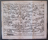
 Trogir, Dalmatian coast. Citta di Trav. Isola de Bua. Nuremberg. Sandrardt Jacob. 1686
Copper engraved miniature map of the Dalmatian coast of Croatia from Sandrart's: Kurtze Beschreibung Von Dem Ursprung/ Aufnehmen/ Gebiete/ und Regierung der Weltberühmten Republick Venedig/ Mehrentheils den Jahren nach/ und in Form einer kurtzen Chronick verabfasset/ Wie auch eine kurtze Beschreibung der vornehmsten Griechischen Provintz und Pen-Insel Morea.
[Description of the origin/absorption/territories/and government of the world-famous Republic of Venice/mostly over the years/and written in the form of a short chronicle/as well as a short description of the most distinguished Greek province and pen island of Morea.]
Black and white, verso blank.
The birdseye/ map shows the city of Trav with the island "Isola de Bua" in front and the mountains behind Folded; Light toning.
113 by 140mm (4½ by 5½ inches). €150
Venetian Possesions In Italy
 Venetian possesions in Italy. Dominium Venetum in Italia. Nuremberg. Sandrardt Jacob. 1686
Copper engraved miniature map of the Venetian possesions in Italy , from Sandrart's: Kurtze Beschreibung Von Dem Ursprung/ Aufnehmen/ Gebiete/ und Regierung der Weltberühmten Republick Venedig/ Mehrentheils den Jahren nach/ und in Form einer kurtzen Chronick verabfasset/ Wie auch eine kurtze Beschreibung der vornehmsten Griechischen Provintz und Pen-Insel Morea.
[Description of the origin/absorption/territories/and government of the world-famous Republic of Venice/mostly over the years/and written in the form of a short chronicle/as well as a short description of the most distinguished Greek province and pen island of Morea.]
Black and white, verso blank. Folded ,[2 vertical folds]. 2 light stains to loer edge of map.
112 by 140mm (4½ by 5½ inches). €150
Verona.
 Verona. Verona. Amphitheatrium Veronese. Nuremberg. Sandrardt Jacob. 1686
Copper engraved miniature view of Verona and the ampitheatre, from Sandrart's: Kurtze Beschreibung Von Dem Ursprung/ Aufnehmen/ Gebiete/ und Regierung der Weltberühmten Republick Venedig/ Mehrentheils den Jahren nach/ und in Form einer kurtzen Chronick verabfasset/ Wie auch eine kurtze Beschreibung der vornehmsten Griechischen Provintz und Pen-Insel Morea.
[Description of the origin/absorption/territories/and government of the world-famous Republic of Venice/mostly over the years/and written in the form of a short chronicle/as well as a short description of the most distinguished Greek province and pen island of Morea.]
Black and white, verso blank. Folded.
View of the city with an architectural detail of the ampitheatre below, 2 views on 1 page Folded ; margin trimmed close to black line on lower left.
140 by 113mm (5½ by 4½ inches). each print 69mm in height €150
Zadar / Zara on The Dalmatian Coast of Croatia.
 Zadar, Dalmatian coast. Zarra Nuremberg. Sandrardt Jacob. 1686
Copper engraved miniature map of the Dalmatian coast of Croatia , from Sandrart's: Kurtze Beschreibung Von Dem Ursprung/ Aufnehmen/ Gebiete/ und Regierung der Weltberühmten Republick Venedig/ Mehrentheils den Jahren nach/ und in Form einer kurtzen Chronick verabfasset/ Wie auch eine kurtze Beschreibung der vornehmsten Griechischen Provintz und Pen-Insel Morea.
[Description of the origin/absorption/territories/and government of the world-famous Republic of Venice/mostly over the years/and written in the form of a short chronicle/as well as a short description of the most distinguished Greek province and pen island of Morea.]
Black and white, verso blank.
The map shows the city and island of Zadar/ Zara. Folded; Light toning.
113 by 140mm (4½ by 5½ inches). €150
Minature map of Rhodes
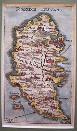 The Island of Rhodes. "Rhodis Insula" Nurnberg Sandrart, Jacob von . 1682-6
Copper engraved minature map from Sandrardt's "Kurze Beschreibung von Venedig wie auch der Griechisen Provintz und Pen-Insel Morea sanbt der jetzigen Kreigs-Handlung,". Modern hand colour; verso blank. Dark impression.
Zacharakis: 3116/2068 113 by 65mm (4½ by 2½ inches). €250
Turkey, Asia Minor.
 A.d'Winter
Anatolia. Anatolien.. Amsterdam Francois Halma 1705
A.d'Winter
Anatolia. Anatolien.. Amsterdam Francois Halma 1705Copper engraved map of " Anatolia" Turkey by N. Sanson from Halma's Algemeene Werelde BeschryvingVol. 3 Black and white; title in Dutch; verso blank; strapwork title cartouche.
This map appeared in Algemeene Weereld-Beschryving, nae de Rechte Verdeeling der Landschappen, Plaetsen, Zeeën, Rivieren, &c. Geographisch, Politisch, Historisch, Chronologisch en Genealogisch, a Dutch edition of A. Phérotée de la Croix's Nouvelle Methode Pour Apprendre Facilement la Geographie Universelle, which first appeared in 1690. Dark impression. Upper margin short, cut to plate mark ; light dampstaining to lower margin.
Keoman: Hal 1; Phillips 528; Zacharakis 3241/2115 [Sanson] 185 by 236mm (7¼ by 9¼ inches). €130
Brazil.
 A.d'Winter
Brazil Brasil, waar van de Kust door de Portugeezen bezeten, .... Amsterdam Francois Halma 1705
A.d'Winter
Brazil Brasil, waar van de Kust door de Portugeezen bezeten, .... Amsterdam Francois Halma 1705Copper engraved map of Brazil by N. Sanson from Halma's Algemeene Werelde BeschryvingVol. 3 Black and white; title in Dutch; verso blank;
Attractive small map of Brazil; title cartouche surrounded by garland of leaves in centre of country.
This map appeared in Algemeene Weereld-Beschryving, nae de Rechte Verdeeling der Landschappen, Plaetsen, Zeeën, Rivieren, &c. Geographisch, Politisch, Historisch, Chronologisch en Genealogisch,a Dutch edition of A. Phérotée de la Croix's Nouvelle Methode Pour Apprendre Facilement la Geographie Universelle, which first appeared in 1690. Dark impression; minor dampstain at top of centre fold.
Keoman: Hal 1; Phillips 528. 202 by 280mm (8 by 11 inches). €350
Sanson's influential map of Canada and the Great Lakes.
 A.d'Winter
Canada of New France. Canada of Niew Vrankryk. Getrokken uit verschiede Franche, Engelsche, en en Hollandsche Beschrivingern enz. ... Amsterdam Francois Halma 1705
A.d'Winter
Canada of New France. Canada of Niew Vrankryk. Getrokken uit verschiede Franche, Engelsche, en en Hollandsche Beschrivingern enz. ... Amsterdam Francois Halma 1705Copper engraved map of Canada by N. Sanson from Halma's Algemeene Werelde BeschryvingVol. 3 Black and white; title in Dutch; verso blank; strapwork title cartouche.
Attractive small map of Canada and the Great Lakes, a reduced version of one of the most influential seventeenth century maps of the French and English colonies in North America. It concentrates on the region of greatest French interest. The entire Great Lakes basin and the St. Lawrence River are shown in great detail. The most important aspect of the map is the first appearance of L. Erie, ou du Chat as a recognizable lake on an atlas map. This delineation influenced the cartography of the region for more than 100 years and was not superceded until Delisle's "Carte du Canada" in 1703. The map is also an outstanding source for Indian tribal names and locations. Two names:Aouentsiouaeronand Attiouandaronsappear here for the first time. Lake Superior and Michigan Lac du Puansare left open-end to the west. Embellished with a nice title cartouche and engraved by Anthoine d'Winter.
This is the third state. Published in Francois Halma's Dutch edition of A. Pherotee de la Croix's Nouvelle Methode Pour Apprendre facilement la Geographie Universelle.
Dark impression; dampstaining to lower margin just entering plate; centrefold and 2 further folds, to fit in binding.
Keoman: Hal 1; Phillips 528; Burden #575; Kershaw #138; McCorkle #683.5. 212 by 308mm (8¼ by 12¼ inches). €500
Chili.
 A.d'Winter
Chili. Chili, Getrokken uit Alfonso de Oualle, Jesuit, en in Dertien Rechts-Gebieden Verdeelt.. Amsterdam Francois Halma 1705
A.d'Winter
Chili. Chili, Getrokken uit Alfonso de Oualle, Jesuit, en in Dertien Rechts-Gebieden Verdeelt.. Amsterdam Francois Halma 1705Copper engraved map of Chili by N. Sanson from Halma's Algemeene Werelde BeschryvingVol. 3 Black and white; title in Dutch; verso blank; strapwork title cartouche.
Small version of Sanson's important map of Chili showing the Cuyo provinces. The map is based on the descriptions of Alfonso de Ovalle.
This map appeared in Algemeene Weereld-Beschryving, nae de Rechte Verdeeling der Landschappen, Plaetsen, Zeeën, Rivieren, &c. Geographisch, Politisch, Historisch, Chronologisch en Genealogisch, a Dutch edition of A. Phérotée de la Croix's Nouvelle Methode Pour Apprendre Facilement la Geographie Universelle, which first appeared in 1690. Dark impression.
Keoman: Hal 1; Phillips 528. 270 by 195mm (10¾ by 7¾ inches). €200
Florida.
 A.d'Winter
Florida. Florida zoo als het van de Spaanschen en Franschen wordt bezeten. ... Amsterdam Francois Halma 1705
A.d'Winter
Florida. Florida zoo als het van de Spaanschen en Franschen wordt bezeten. ... Amsterdam Francois Halma 1705Copper engraved map of Florida by N. Sanson from Halma's Algemeene Werelde BeschryvingVol. 3 Black and white; title in Dutch; verso blank; strapwork title cartouche.
This influential map shows the Spanish and French possessions in the southern part of the United States. The map extends from the southernmost part of Virginia to the coast of what is now Texas. When first introduced by Sanson in 1657, this map was the first to use the name L. Eriein an atlas and to introduce several new rivers in Virginia. The French claims in the Carolinas are reasserted with the region named Floride Francoise, despite the region not having had any French presence for nearly 100 years. The place name Caroline is not related to the future English colony of Carolina. Instead it is a confusion between the French Fort Caroline on the St. Johns River, and Charlefort that was located near Port Royal. According to Burden, this is the third state of the map.
Published in Francois Halma's Dutch edition of A. Pherotee de la Croix's Nouvelle Methode Pour Apprendre facilement la Geographie Universelle.
Dark impression; pin hole paper fault to upper right , below latitude 40.
Keoman: Hal 1; Phillips 528; Burden #546; Cumming (SE) #53. 178 by 255mm (7 by 10 inches). €500
Guatemala .
 A.d'Winter
Guatemala. Landstreek van Guatemala .. Amsterdam Francois Halma 1705
A.d'Winter
Guatemala. Landstreek van Guatemala .. Amsterdam Francois Halma 1705Copper engraved map of Guatemala by N. Sanson from Halma's Algemeene Werelde BeschryvingVol. 3 Black and white; title in Dutch; verso blank; strapwork title cartouche.
This map appeared in Algemeene Weereld-Beschryving, nae de Rechte Verdeeling der Landschappen, Plaetsen, Zeeën, Rivieren, &c. Geographisch, Politisch, Historisch, Chronologisch en Genealogisch, a Dutch edition of A. Phérotée de la Croix's Nouvelle Methode Pour Apprendre Facilement la Geographie Universelle, which first appeared in 1690. Dark impression.
Keoman: Hal 1; Phillips 528; B 187 by 280mm (7¼ by 11 inches). €250
Guyana.
 A.d'Winter
Guyana. Guiana verdeelt Guina en Caribana.. Amsterdam Francois Halma 1705
A.d'Winter
Guyana. Guiana verdeelt Guina en Caribana.. Amsterdam Francois Halma 1705Copper engraved map of Guyana by N. Sanson from Halma's Algemeene Werelde BeschryvingVol. 3 Black and white; title in Dutch; verso blank; strapwork title cartouche.
The map shows a large lake or inland sea Lac, ou Mer que les Caribes appellent Parime les Iaoyi Roponowini.and located on its shores the mythical city of El Doradoor Manoa.
Lake Parime or Lake Parimais a legendary lake located in South America. It was reputedly the location of the fabled city of El Dorado,also known as Manoa, much sought-after by European explorers. Repeated attempts to find the lake failed to confirm its existence, and it was dismissed as a myth along with the city. The search for Lake Parimeled explorers to map the rivers and other features of southern Venezuela, northern Brazil, and southwestern Guyana before the lake's existence was definitively disproved in the early 19th century. Some explorers proposed that the seasonal flooding of the Rupununi savannahmay have been misidentified as a lake. Recent geological investigations suggest that a lake may have existed in northern Brazil, but that it dried up some time in the 18th century. Both "Manoa"(Arawak language) and "Parime" (Carib language) are believed to mean "big lake".
This map appeared in Algemeene Weereld-Beschryving, nae de Rechte Verdeeling der Landschappen, Plaetsen, Zeeën, Rivieren, &c. Geographisch, Politisch, Historisch, Chronologisch en Genealogisch, a Dutch edition of A. Phérotée de la Croix's Nouvelle Methode Pour Apprendre Facilement la Geographie Universelle,which first appeared in 1690. Dark impression.
Keoman: Hal 1; Phillips 528. 202 by 280mm (8 by 11 inches). €200
Magellanica: Tierra del Fuego.
 A.d'Winter
Magellanica. De Straat van Magellanes met het Magellanisch Landt en d'Eilanden.. Amsterdam Francois Halma 1705
A.d'Winter
Magellanica. De Straat van Magellanes met het Magellanisch Landt en d'Eilanden.. Amsterdam Francois Halma 1705Copper engraved map of Peru by N. Sanson from Halma's Algemeene Werelde BeschryvingVol. 3 Black and white; title in Dutch; verso blank; strapwork title cartouche.
Small map of Tierra del Fuego showing both the Strait of Magellan and Le Maire Strait. Inland detail is confined to a mountain range and several rivers, and the mythical Destroit de Browers is labeled at far right.
This map appeared in Algemeene Weereld-Beschryving, nae de Rechte Verdeeling der Landschappen, Plaetsen, Zeeën, Rivieren, &c. Geographisch, Politisch, Historisch, Chronologisch en Genealogisch, a Dutch edition of A. Phérotée de la Croix's Nouvelle Methode Pour Apprendre Facilement la Geographie Universelle, which first appeared in 1690. Dark impression.
Keoman: Hal 1; Phillips 528. 191 by 243mm (7½ by 9½ inches). €300
Mexico and the Yucatan Peninsular.
 A.d'Winter
Mexico. T Gebiedt van Mexico... Amsterdam Francois Halma 1705
A.d'Winter
Mexico. T Gebiedt van Mexico... Amsterdam Francois Halma 1705Copper engraved map of Mexico by N. Sanson from Halma's Algemeene Werelde BeschryvingVol. 3 Black and white; title in Dutch; verso blank; strapwork title cartouche.
The map shows Mexico including the Yucatan peninsula, part of present-day Guatemala and Honduras.
This map appeared in Algemeene Weereld-Beschryving, nae de Rechte Verdeeling der Landschappen, Plaetsen, Zeeën, Rivieren, &c. Geographisch, Politisch, Historisch, Chronologisch en Genealogisch, a Dutch edition of A. Phérotée de la Croix's Nouvelle Methode Pour Apprendre Facilement la Geographie Universelle, which first appeared in 1690. Dark impression.
Keoman: Hal 1; Phillips 528; B 173 by 280mm (6¾ by 11 inches). €250
California as an Island.
 A.d'Winter
North America. Noorder America. Amsterdam Francois Halma 1705
A.d'Winter
North America. Noorder America. Amsterdam Francois Halma 1705Copper engraved map of North America by N. Sanson from Halma's Algemeene Werelde BeschryvingVol. 3 Black and white; title in Dutch; verso blank; strapwork title cartouche.
Attractive small map showing North America with California as an Island
California is shown with an indented northern coastline in the Foxe form. The detached coastline to the northwest of California is named Terre de Iesso ou Ieco,rather than reflecting Sanson's earlier belief that it was an extension of the American continent. The R. de Nortdrains into the Gulf of California from a large interior lake in the country of Les Apaches. The two western-most Great Lakes are left open-ended and Lake Erieremains unnamed. Engraved by Antoine d'Winter. This is the third state which includes a peninsula inserted northeast of California, the Carolinas attributed to the French, N. Iork added below N. Amstredam, and an umlaut over the "Roy" in the title.
This map appeared in Algemeene Weereld-Beschryving, nae de Rechte Verdeeling der Landschappen, Plaetsen, Zeeën, Rivieren, &c. Geographisch, Politisch, Historisch, Chronologisch en Genealogisch, a Dutch edition of A. Phérotée de la Croix's Nouvelle Methode Pour Apprendre Facilement la Geographie Universelle, which first appeared in 1690. Dark impression; dampstaining to edges not entering image.
Keoman: Hal 1; Phillips 528; Burden #545; McLaughlin #89-3. 204 by 284mm (8 by 11¼ inches). €700
Paraguay.
 A.d'Winter
Paraguay. Paraguay Verdeelt in zyn Voornaamste Deelen Volgens de Laatste Reisbeschryvinge .... Amsterdam Francois Halma 1705
A.d'Winter
Paraguay. Paraguay Verdeelt in zyn Voornaamste Deelen Volgens de Laatste Reisbeschryvinge .... Amsterdam Francois Halma 1705Copper engraved map of Paraguayby N. Sanson from Halma's Algemeene Werelde BeschryvingVol. 3 Black and white; title in Dutch; verso blank; strapwork title cartouche.
The map shows the region of present day Paraguay, Uruguay, northern Argentina and southern Brazil. The Rio de la Plata is the main feature of the map along with the mountains and volcanoes of the Cordillera de los Andes. Engraved by Antoine de Winter.
This map appeared in Algemeene Weereld-Beschryving, nae de Rechte Verdeeling der Landschappen, Plaetsen, Zeeën, Rivieren, &c. Geographisch, Politisch, Historisch, Chronologisch en Genealogisch, a Dutch edition of A. Phérotée de la Croix's Nouvelle Methode Pour Apprendre Facilement la Geographie Universelle, which first appeared in 1690. Dark impression; minor dampstain at top of centre fold.
Keoman: Hal 1; Phillips 528. 210 by 280mm (8¼ by 11 inches). €200
Peru.
 A.d'Winter
Peru. Peru, en de Loop van den Amazoonstroom.. Amsterdam Francois Halma 1705
A.d'Winter
Peru. Peru, en de Loop van den Amazoonstroom.. Amsterdam Francois Halma 1705Copper engraved map of Peru by N. Sanson from Halma's Algemeene Werelde BeschryvingVol. 3 Black and white; title in Dutch; verso blank; strapwork title cartouche.
The map shows the western part of the continent and the full course of the Amazon. The spurious Lac, ou Mer de Parime is prominent as is the location of the mythical city Manoa el Dorado.
This map appeared in Algemeene Weereld-Beschryving, nae de Rechte Verdeeling der Landschappen, Plaetsen, Zeeën, Rivieren, &c. Geographisch, Politisch, Historisch, Chronologisch en Genealogisch, a Dutch edition of A. Phérotée de la Croix's Nouvelle Methode Pour Apprendre Facilement la Geographie Universelle, which first appeared in 1690. Dark impression. Upper margin short, cut to plate mark.
Keoman: Hal 1; Phillips 528. 207 by 195mm (8¼ by 7¾ inches). €200
Caribbean Islands.
 A.d'Winter
The Antilles, Bahamas and Caribbean Islands. De Antillische Eilanden waar onder zyn de Lucaysche en Caribesche.. Amsterdam Francois Halma 1705
A.d'Winter
The Antilles, Bahamas and Caribbean Islands. De Antillische Eilanden waar onder zyn de Lucaysche en Caribesche.. Amsterdam Francois Halma 1705Copper engraved map of Caribbean by N. Sanson from Halma's Algemeene Werelde BeschryvingVol. 3 Black and white; title in Dutch; verso blank; strapwork title cartouche.
The map shows the islands of the Caribbean with the tip of Florida to the North and the coast line of Honduras and Venezuela to the South
This map appeared in Algemeene Weereld-Beschryving, nae de Rechte Verdeeling der Landschappen, Plaetsen, Zeeën, Rivieren, &c. Geographisch, Politisch, Historisch, Chronologisch en Genealogisch, a Dutch edition of A. Phérotée de la Croix's Nouvelle Methode Pour Apprendre Facilement la Geographie Universelle, which first appeared in 1690. Dark impression. Upper margin short, cut to plate mark ; extra folds to fit in binding; light dampstaining to lower margin, just entering plate.
Keoman: Hal 1; Phillips 528. 215 by 280mm (8½ by 11 inches). €350
The Black Sea.
 A.d'Winter
The Black Sea. De Zwart Zee eertyts Pontus Euxinus. Amsterdam Francois Halma 1705
A.d'Winter
The Black Sea. De Zwart Zee eertyts Pontus Euxinus. Amsterdam Francois Halma 1705Copper engraved map of the Black Sea by N. Sanson from Halma's Algemeene Werelde BeschryvingVol. 3 Black and white; title in Dutch; verso blank; strapwork title cartouche.
This map appeared in Algemeene Weereld-Beschryving, nae de Rechte Verdeeling der Landschappen, Plaetsen, Zeeën, Rivieren, &c. Geographisch, Politisch, Historisch, Chronologisch en Genealogisch, a Dutch edition of A. Phérotée de la Croix's Nouvelle Methode Pour Apprendre Facilement la Geographie Universelle, which first appeared in 1690. Dark impression.
Keoman: Hal 1; Phillips 528; Zacharakis 3244/2518. 180 by 240mm (7 by 9½ inches). €100
Colombia and Venezuela.
 A.d'Winter
The New Kingdom of Granada. T Vaste Landt van 't Niew Koningryk Granada. Amsterdam Francois Halma 1705
A.d'Winter
The New Kingdom of Granada. T Vaste Landt van 't Niew Koningryk Granada. Amsterdam Francois Halma 1705Copper engraved map of Colombia, Venezuela and Panama by N. Sanson from Halma's Algemeene Werelde BeschryvingVol. 3 Black and white; title in Dutch; verso blank; strapwork title cartouche.
The map shows the Isthmus of Panama and North Western South America including most of present day Columbia and part of Venezuela. Regional boundaries are shown along with missions, towns, major rivers and mountains. The mythical Lage de Parime with the fabled city of Manoa del Doradois shown at bottom right.
This map appeared in Algemeene Weereld-Beschryving, nae de Rechte Verdeeling der Landschappen, Plaetsen, Zeeën, Rivieren, &c. Geographisch, Politisch, Historisch, Chronologisch en Genealogisch, a Dutch edition of A. Phérotée de la Croix's Nouvelle Methode Pour Apprendre Facilement la Geographie Universelle, which first appeared in 1690. Dark impression.
Keoman: Hal 1; Phillips 528. 194 by 290mm (7¾ by 11½ inches). €200
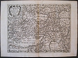
Turkey in Asia.
 A.d'Winter
Turkey in Asia. Turkeyen in Asia. Amsterdam Francois Halma 1705
A.d'Winter
Turkey in Asia. Turkeyen in Asia. Amsterdam Francois Halma 1705Copper engraved map of Turkey in Asia by N. Sanson from Halma's Algemeene Werelde BeschryvingVol. 3 Black and white; title in Dutch; verso blank; strapwork title cartouche.
A general map showing Turkey and the Caucases , with the coast of Greece and North Africae extending to the Caspian Sea in the East
This map appeared in Algemeene Weereld-Beschryving, nae de Rechte Verdeeling der Landschappen, Plaetsen, Zeeën, Rivieren, &c. Geographisch, Politisch, Historisch, Chronologisch en Genealogisch, a Dutch edition of A. Phérotée de la Croix's Nouvelle Methode Pour Apprendre Facilement la Geographie Universelle, which first appeared in 1690. Dark impression. Upper margin short, cut to plate mark ; light dampstaining to lower margin.
Keoman: Hal 1; Phillips 528. 192 by 252mm (7½ by 10 inches). €130
The British isles
 British Isles , great Britain and Ireland with the Orkneys, Hebrides, and the Scilly Isles . " Brittanicæ Insulæ in quibis Albium sive Brittania Maior, Ivernia sive Brittania Minor tum et Orcades, Ebudes, Cassiterides." Paris Par N Sanson ... Chez Pierre Mariette. 1641
Copper engraved map of the British isles by Nichols Sanson from his "Cartes Generales De Toutes Les Parties Du Monde". Original outline colour; verso blank.
The map shows the British Isles and part of the adjacent coast of Europe.
Black & white strapwork title cartouche. Good impression; slight dampstaining to edges, far from plate; minor spotting mainly to blank margins; old ink number to upper right corner.
David Rumsey:9741.000 412 by 540mm (16¼ by 21¼ inches). €280
The Caribbean, the Antilles and the Lucayan Archipelgo.
 The Antilles and the Lucayes and Caribs in between " Les Antilles &c. Entre lesquelles sont Les Lucayes, et Les Caribes" Paris Par N Sanson ... Chez Pierre Mariette. 1656-8
Copper engraved map of the Caribbean by Nichols sanson from his"Cartes Generales De Toutes Les Parties Du Monde". Original outline colour; verso blank.
The map shows all the islands of the Caribbean with the southern tip of Florida and the coasts to the south.
Decorative title cartouche . Good impression; slight dampstaining to edges, far from plate ; small stain just below cartouche.
395 by 556mm (15½ by 22 inches). €1200
Corsica.
 Corsica divided into her ten Provinces or Jurisdictions and her four Fiefs "Carte Particuliere de L'Isle de Corse Divisee par ses Dix Provinces ou Juridictions et ses quatre Fiefs." Venice, Remondini, 1776
Copper engraved map of Corsica after Jaillot, from Santini's "Atlas universel dressé sur les meilleures cartes modernes". Original outline colour; verso blank.
The map shows the island in large scale filling the page,indeed almost escaping the scale lines, so that the "Capo Corso" is shown as an inset vignette. Large decorative title cartouche upper right, table of remarks to lower left below inset map. Dark impression; paper lightly toned.
Phillips 647; Cervoni, F., Image de la Corse, 112.1. 487 by 667mm (19¼ by 26¼ inches). €600
Company: Bryan, Mary Louise.
Address: Ag. Andrianoy 92 , 21 100 Nafplio, Greece.
Vat No: EL 119092581