MAPS & VIEWS
PRINTS
BOOKS
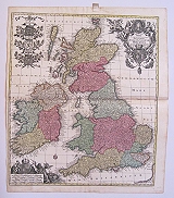
The British Isles.
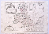
 British Isles. "Brittanicæ Insulæ in quibis Albion Seu Brittania Major, et ivernia Seu Brittania Minor juxta Ptolemæi mentem divisæ..... à Ncolao Sanson ... redacte accurante Robert de Vaugondy..." Venice, Remondini, 1779
Copper engraved map of the British isles from Santini's "Atlas universel dressé sur les meilleures cartes modernes". Original outline colour; verso blank.
The map after Vaugondy is based on that of Nicolas Sanson [see items 3621 & 3262] Dark impression; some light soiling; horizontal crease to left.
488 by 555mm (19¼ by 21¾ inches). €150
British Isles.
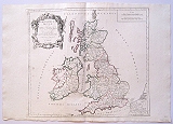
 British isles.. "Les Isles Brittaniques Comprenent les Royaumes d'Angleterre, d'ecosse et d'Irelande, divisés en Grandde Provinces, subdivisés par Comtés ....Par Le Sr Janvier Geographe.." Venice, Remondini, 1779
Copper engraved map of the British Isles from Santini's "Atlas universel dressé sur les meilleures cartes modernes". Original outline colour; verso blank.
The map after Janvier Shows the British Isles with part of the adjacent coast of France, Holland, Denmark, and Norway. Inset map of the Orkneys and Shetland.
Decorative title cartouche; strapwork scale. Dark impression; some light soiling to blank margins.
490 by 668mm (19¼ by 26¼ inches). €200
England & Wales.
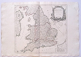 England & Wales. "Le Royaume d'Angleterre, divisé selon les sept Royaume ,ou de Heptarchie des Saxons, avec La Principauté de Galles et subdivisé en Shires ou Comtés Par le Sr Robert." Venice, Remondini, 1778
Copper engraved map of England & Wales from Santini's "Atlas universel dressé sur les meilleures cartes modernes". Original outline colour; verso blank.
The map By Giles, Robert de Vaugondy names the towns and counties of its day the outline colour is used to show the Kingdoms of the Anglo-Saxon Heptarchy and the Principality of Wales.
Black & white strapwork cartouche. Dark impression.
Pedley, Bel et Utile: the Work of the Robert de Vaugondy Family of Mapmakers, 52. 478 by 520mm (18¾ by 20½ inches). €150
Scotland
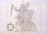 Scotland "L'Ecosse divisée en Shires ou Comtés Par le Sr Robert." Venice, Remondini, 1778
Copper engraved map of Scotland from Santini's "Atlas universel dressé sur les meilleures cartes modernes". Original outline colour; verso blank.
The map By Giles, Robert de Vaugondy, Includes the Hebrides and part of the coast of Ireland, but only Hoy and the Mainland of the Orkneys
Black & white strapwork cartouche. Dark impression; light spotting to lower blank margin; printers crease to right blank margin, far from image.
Pedley, Bel et Utile: the Work of the Robert de Vaugondy Family of Mapmakers, 52. 496 by 582mm (19½ by 23 inches). €200
India and Indochina.
 The East Indies and the distinguished Empires and Kingdoms therein, taken from the Neptune Oriental by S.Robert. "Les Indes Orientaes, où sont distingués les Empires et Royaumes qu'elles contiennent tirée du Neptune Oriental Par Le S. Robert." Venice, Remondini, 1779
Copper engraved map of India & Indochina from Santini's "Atlas universel dressé sur les meilleures cartes modernes". Original outline colour; verso blank.
The map is a reissue of the map by Robert de Vaugondy' from his "Atlas Universel"first published in 1757; it shows the Indian sub-continent, Indochina and the Malay peninsular with the northern tip of Sumatra.
Title cartouche to upper right. Dark impression; dampstain to upper right corner.
498 by 582mm (19½ by 23 inches). €300
The Antilles & Bahamas.
 The Greater & Lesser Antilles and the Lucaye islands with part of the North Sea. "Les Grandes et Petit Isles Antilles et les Iles Lucayes avec une partie de la Mer Nord Par Le S. Robert." Venice, Remondini, 1779
Copper engraved map of the Antilles and Lucayan Archipelago /Bahamas from Santini's "Atlas universel dressé sur les meilleures cartes modernes". Original outline colour; verso blank.
The map is a reissue of the map by Robert de Vaugondy' from his "Atlas Universel"first published in 1757; it shows the islands of the Caribbean with the tip of Florida with the Keys and the coasts of Honduras,Costa Rica and South America .
Title cartouche to upper right, decorated with ships, shells and fishing nets. Dark impression; minor spotting mainly to blank margins.
480 by 595mm (19 by 23½ inches). €600
Ireland.
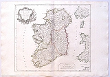 The Kingdom of Ireland "Le Royaume d'Irelande divise en ses Quatres Provinces et subdivisé en Comtés Par le Sr Robert." Venice, Remondini, 1778
Copper engraved map of Ireland from Santini's "Atlas universel dressé sur les meilleures cartes modernes". Original outline colour; verso blank.
The map By Giles, Robert de Vaugondy names the towns and counties of its day, whilst the outline colour is used to denote the four provinces., with part of the coasts of Wales and Scotland; the Isle of Man; part of the coast of North Devon and Lundy Island.
Black & white strapwork cartouche. Dark impression; printers crease to lower margin.
Pedley, Bel et Utile: the Work of the Robert de Vaugondy Family of Mapmakers, 52. 480 by 542mm (19 by 21¼ inches). €250
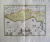
The Island of Sardinia.
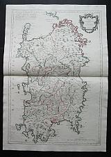 The Kingdom of Sardinia. "Le Royaume de Sardaigne." Venice, Remondini, 1779
Copper engraved map of Sardinia, from Santini's "Atlas universel dressé sur les meilleures cartes modernes". Original outline colour; verso blank.
The map shows the island in large scale with parts entering the scale lines, with part of Corsica to top.
Decorative title cartouche upper right, text giving the history of the island upper lef and list ogf mineral mines to lower left Dark impression; paper lightly toned.
Phillips 647. 693 by 474mm (27¼ by 18¾ inches). €700
Guinea, West Africa.
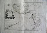 Guinea with the Capo Verde iislands, Senegal, the coast of Guinea itself and the Kingdoms of Loango, Congo, Angola and Benguela. " Carte de la Guinée contenant les Isles du Cap Verd, le Senegal, la Côte de Guinée proprement dite, les Royaumes de Loango, CongoAngola et Benguela...." Venice, Remondini, 1779
Copper engraved map of West Africa from Santini's "Atlas universel dressé sur les meilleures cartes modernes". Original outline colour; verso blank.
The map after Bonne shows the coastal regions of West Africa, with an inset map of the Gold coast after d'Anville.
Black & white decorative title cartouche with a lion or leopard and large crocodile. Dark impression; some light staining to blank margins.
460 by 625mm (18 by 24½ inches). €200
Scapula Lexicon.
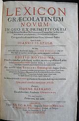 Lexicon GræcoLatinum Novum. Lexicon Græco-Latinum novum : in quo ex primitivorum & simplicium fontibus derivata atque composita (ordine non minùs naturali, quàm alphabetico,) breviter & dilucidè deducuntur. Cui appendix est exactissimus Græci idiomatis index oper & studio Ioannis Scapulæ. Ad hæc, auctarium extat dialectorum omnium à Iacobo Zvingero Phil. & Med. Basil. in expeditas succinctâsque tabulas compendiosè redactarum. Editio novissima, prioribus omnibus quibuscun[que] auctior, annexo copiosissimo Latino indice Laurentij Martij Palatini ... Huc accessit etiam lexicon etymologicum linguæ Græcæ ... Autore, Ioanne Harmaro ex celeberrima Academia Oxoniensi Londini London Typis T(homæ )H(arperi), T(homas )C(otes), and A(nne )G(riffin,) impensis Iocosæ Norton. & Richardi Whitakeri. Prostant ad Insignia Regia, in Cœmeterio D. Pauli, st. 1637.
Folio; 4 parts in 1:[12] p., 1856 columns, [187] p., 7-190 columns, [241] p.; [4] p., 64 columns;
Title page in red and black; the roman numeral date is made with turned C's. titles to each part with colophons.
Index Latinus (unpaginated, , ²A-²V) has separate dated title page with excudebat Tho. Cotes in imprint. Lexicon etymologicum linguae Graecae has separate register and dated title page with typis Annae Griffin in imprint.
Cotes and Griffin also pr[inted]. sections of pt.1
The colophon to Appendixis dated 1636 Apud Richardum Whittakerum
Later [19th century?] diced calf ; six raised bands gilt; marbled end papers,
The volume includes
Part!:Lexicon Græco-Latinum novum in 1856 columns, plus index;
Part 2 : Iacobi Zvingeri ... Græcarum dialectorum Hypotyposis& Apendixeorum Quae Insipso Lexico Commode;
Part 3: Index Latinos in Iohannis Scapulæ Lexicon Græco latinum.... Laurenti Martii Palatini;
Part 4:Lexicon Etymologicum Linguæ Græcæ ... Ioanne Harmaro
Joints with light rubbing; spotting to blank side of end papers; internally generally clean and crisp. rear inner joint starting.
Part 2; Appendix: ß1 & ß2 stuck together at inner gutter; ß5page loose, never stitched in.
Part 3 Index Latinus: tear to margin of G4 just touching textwith loss to blank margin but not text.
1 Clark's Bibliog. Dict. vol. IV.*-Balllet Jugemens.Morhoff Poly hist.;George Lillie Craik.The Pursuit of Knowledge Under Difficulties, Volume 8 page 161-3. 350 by 235mm (13¾ by 9¼ inches). €850
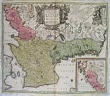
Perche & Blasois, France.
 The County of Blaisois. The County of Perche. "Comitatus Blesensis, Auctore Joanne Temporio. Blaisois." & " Perchensis Comitatus. La Perche Comte". Amsterdam Schenk, Petri & Valk Gerardi c1700
Copper engraved maps, 2 on 1 plate of of the region of Blaisois and Perche in France from Schenk And Valk's " Atlas Contractus." Original full wash colour; verso blank.
The map shows the region of Blaisois with the capital Blois on the Loire in the Loir-et-Cher department and Perche former province of western France extending over the départements of Orne, Eure, Eure-et-Loir and Sarthe,from which many emigrated to Canada in the 17th century leading to most French Canadians being able to trace their ancestry back to this region,
Each map with decorative title cartouche. Dark impression; clean and bright; green lines slightly oxidised/browned, small cracking near centre of centrefold. along the Loire on map of Blaisois; 1 wormhole to map of Blaisois, by town of St Laurent with another in the blank margin above; 2 old ink numbers to upper right corner, and one to verso.
Koeman III,page 113, map 280. 402 by 510mm (15¾ by 20 inches) full plate. €200
The North Pole.
 The North Pole and the adjacent Arctic lands Newly and Accurately Described. "Novi et Acurata Poli Arctici et terrarum Circum Iacentium Descriptio." Amsterdam Schenk, Petri & Valk Gerardi c1700
Copper engraved map of the Arctic, the North Pole and adjacent lands from Schenk And Valk's " Atlas Contractus." Original full wash colour; verso blank
The map from the plate by Janssonius was originally published in 1637, eventually replaced Hondius' map of the North Pole and became the prototype for many later maps including those of Blaeu.
Rhumb lines radiate from the North Pole and several compass roses and ships embellish the chart. A large title cartouche, with two figures and numerous wind heads, conveniently hides the northwest coast of America. Small cartouche depicting men, a polar bear and foxes at lower right with the imprint of Schenk and Valk.
Fifth state of the plate with Nova Zembla connected to the mainland with a land bridge and the completed coastline of Spitzbergen . Good impression with bright colour; generally clean; a few spots to blank margins; short centre old split at lower margin [approx 20mm backed with archival tape].
The maps of Schenk and Valk are famous for their full wash colour , however often the pigments, particularly in the greens deteriorated leading to browning and eventually could cause the paper to crack, for this reason it is unusual to see such bright original colour.
Koeman III,page 115 Sche 2/ Val1. 410 by 518mm (16¼ by 20½ inches). €1000
Beauce, France.
 The Region of Beauce "Belsia Vulgo La Beausse." Amsterdam Schenk, Petri & Valk Gerardi c1700
Copper engraved map of the region of Beauce in France from Schenk And Valk's " Atlas Contractus." Original full wash colour; verso blank.
The map shows the agricultural region of Beauce with the capital Chartres.
Decorative title cartouche, with Ceres harvesting grain and a cart drawn by dragons; coat of arms upper right with scale. Dark impression; clean and bright; old ink number to verso.
The maps of Schenk and Valk are famous for their full wash colour , however often the pigments, particularly in the greens deteriorated leading to browning and eventually could cause the paper to crack, for this reason it is unusual to see such bright original colour.
Koeman III,page 113, map 281. 384 by 496mm (15 by 19½ inches). €250
Blaisois, France.
 The Region of Blois, Blaisois. "Description du Blaisois." Amsterdam Schenk, Petri & Valk Gerardi c1700
Copper engraved map of the region of Blaisois in France from Schenk And Valk's " Atlas Contractus." Original full wash colour; verso blank.
The map shows the region of Blaisois with the capital Blois on the Loire in the Loir-et-Cher department.
Decorative title cartouche, scale and coat of arms. Dark impression; clean and bright; old ink number to verso.
The maps of Schenk and Valk are famous for their full wash colour , however often the pigments, particularly in the greens deteriorated leading to browning and eventually could cause the paper to crack, for this reason it is unusual to see such bright original colour.
Koeman III,page 113, map 282? 372 by 485mm (14¾ by 19 inches). €200
Guinea, West Africa.
 Guinea. "Guinea." Amsterdam Schenk, Petri & Valk Gerardi c1700
Copper engraved map of Guinea, West Africa after Janssonius from Schenk and Valk's " Atlas Contractus." Original full wash colour; verso blank.
The map after Jansonnius shows the coast of West Africa from Sierra Leone to Gabon, focused upon Guinea and Benin; numerous elephants, lions and monkeys within the land; ships, monsters and compass roses to sea.
Decorative title cartouche surmounted by natives and monkeys; 2 black putti bear an elephant tusk above the sea at bottom left corner. Good impression with bright colour; worm track to upper centre fold in blank margin with old paper repair to verso, not entering image.
The maps of Schenk and Valk are famous for their full wash colour , however often the pigments, particularly in the greens deteriorated leading to browning and eventually could cause the paper to crack, for this reason it is unusual to see such bright original colour.
Koeman III, page 114 Map 446; Sche 2/ Val1. 380 by 514mm (15 by 20¼ inches). €500
North Africa and the Barbary coast.
 New Barbary described. "Nova bARBARIæ DESCRIPTIO." Amsterdam Schenk, Petri & Valk Gerardi c1700
Copper engraved map of North Africa from Schenk and Valk's " Atlas Contractus." Original full wash colour to Barbary, otherwise outline colour; verso blank.
The map shows the coast of North Africa and most of the Mediterranean sea with cities in Spain and Portugal particularly marked. Along the coast are the various North African kingdoms. Fez Tunis etc, which make up "Barbary" The course of the Nile is shown with much detail as are the other rivers. Numerous texts give information, The whole land is decorated with wild animals; elephants, antelopes, lions, leoprds, camels, ostriches, monkeys, crocodiles and even dragons.
Decorative title cartouche, black and white as issued. Good impression with bright colour.
The maps of Schenk and Valk are famous for their full wash colour , however often the pigments, particularly in the greens deteriorated leading to browning and eventually could cause the paper to crack, for this reason it is unusual to see such bright original colour.
Koeman III, page 114 Map 407; Sche 2/ Val1. 352 by 513mm (13¾ by 20¼ inches). €350
Æthiopia, Abyssinia, the Kingdom of Prester John.
 Æthiopia, Superior and Inferior commonly called Abyssinia or the Kingdom of Prester John. "Aethiopia Superior vel Interior vulgo Abissinorum sive Prebiteri Joannis Imperium." Amsterdam Schenk, Petri & Valk Gerardi c1700
Copper engraved map of East Africa Æthiopia from Schenk and Valk's " Atlas Contractus." Original full wash colour; verso blank.
The map shows a major section of central and eastern Africa including Mozambique north to present day Sudan
The map contains numerous coastal place names such as Mozambique Island, Quiloa, Mombaza, and Melinde indicating the importance of the area to both Arab, Portuguese, and traders and explorers from other countries. Congo is shown on the west coast and the two lakes of Zaire and Zaflan described by Ptolomy are in the lower portion of the map. Lake Niger, and the supposed course of the Niger River, is shown flowing westward. This map is based on Ortelius' map of Prester John of 1573.
Decorative title cartouche, black and white as issued; elephants, ostriches and monkeys within the land.
The legends of Prester John (also Presbyter Johannes) were popular in Europe from the 12th through the 17th centuries, and told of a Christian patriarch and king said to rule over a Christian nation lost amidst the Muslims and pagans in the Orient. Written accounts of this kingdom are variegated collections of medieval popular fantasy. Prester John was reportedly a descendant of one of the Three Magi, said to be a generous ruler and a virtuous man, presiding over a realm full of riches and strange creatures, in which the Patriarch of the Saint Thomas Christians resided. His kingdom contained such marvels as the Gates of Alexander and the Fountain of Youth, and even bordered the Earthly Paradise. Among his treasures was a mirror through which every province could be seen, the fabled original from which the "speculum literature" of the late Middle Ages and Renaissance was derived, in which the prince's realms were surveyed and his duties laid out.
At first, Prester John was imagined to reside in India; tales of the Nestorian Christians' evangelistic success there and of Thomas the Apostle's subcontinental travels as documented in works like the Acts of Thomas probably provided the first seeds of the legend. After the coming of the Mongols to the Western world, accounts placed the king in Central Asia, and eventually Portuguese explorers convinced themselves that they had found him in Ethiopia, which had been officially Christian since the 4th century. Prester John's kingdom was thus the object of a quest, firing the imaginations of generations of adventurers, but remaining out of reach. He was a symbol to European Christians of the Church's universality, transcending culture and geography to encompass all humanity, in a time when ethnic and inter-religious tension made such a vision seem distant. Good impression with bright colour.
The maps of Schenk and Valk are famous for their full wash colour , however often the pigments, particularly in the greens deteriorated leading to browning and eventually could cause the paper to crack, for this reason it is unusual to see such bright original colour.
Koeman III, page 114 Map 447; Sche 2/ Val1. 380 by 514mm (15 by 20¼ inches). €600
Scarce Small Map of Corfu.
 The Island of Corfu.... Kerkyra. "Het Eilant Corfu.... Corcyra...." Amsterdam Schenk, Petri 1716=1720
Copper engraved map of Corfu/Kerkyra by Petrus Schenk. Modern hand colour; verso blank.
Scarce small map of the island of Corfu, taken from a larger map sheet , probably from "Schouwburg van den oorlog, beginnende van Koning Karel den II, tot op Koning Karel den III Theatrum bellicum, incipiens a Carolo II. Hispaniarum Rege ad Carolum III. Amsterdam: Pieter Schenk."[1714-1720]
The map is drawn upon a drape or wall hanging with fringe; it shows the island lying off the coast , with the large bay of Butrinto . the text below in Dutch and French discusses the events of July 8th 1716. known as
The Siege of Corfu;after their success in the Morea, the Ottomans moved against the Venetian-held Ionian Islands. They had occupied the island of Lefkada (Santa Maura), which the Venetians had taken in 1684, and the fort of Butrinto opposite Corfu. On 8 July 1716, an Ottoman army of 33,000 men landed on Corfu, the most important of the Ionian islands. Despite an indecisive naval battle on the same day, the Ottoman land army continued its disembarkment and advanced towards the city of Corfu. On 19 July, after capturing the outlying forts of Mantouki, Garitsa, Avrami and of the Saviour, the siege began.[The defence was led by Count Johann Matthias von der Schulenburg, who had roughly 8,000 men at his command. The extensive fortifications and the determination of the defenders withstood several assaults. After a great storm on 9 August—which the defenders attributed to the intervention of Corfu's patron saint, Saint Spyridon—caused significant casualties among the besiegers, the siege was broken off on 11 August and the last Ottoman forces withdrew on 20 August. Good impression. good margins to left and bottom but short top and right as it has obvoiusly been cut from a larger sheet.
Zacharakis; 3275/2139;Koeman III, page 116 Sche 7 160 by 180mm (6¼ by 7 inches). Pagesize;200x280mm. €500
Cartographic Curiosity: the Houses of Braunschweig, Lunenburg and the House of Stuart
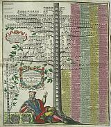 Genealogical tree of Braunschweig & Lunenburg, and the House of Stuart of Great Britain. "Neu inventierter Genealogisch. Stam Baum des Uhrhalten Hoch Fürstlich. nun mehr. auch Fürstlich u. Gross Brittanischen Königl Hauses Braunschweig Lünenburg...." Augsburg SEUTTER MATTHÄUS 1734
Copper engraved genealogical plate by Matthaus Seutter from his " Grosser Atlas," Original full colour; verso blank.
The image shows a Genealogical tree with a King reclining below; to the left a small tree of the House of Stuart. Seutter shows how the families became linked so that a German became King of Great Britain.
Decorative title cartouche, black and white as issued; two heraldic coats of arms. Dark impression; Damage at centrefold where adhesion had caused a tear repaired; light foxing in places.
580 by 520mm (22¾ by 20½ inches). €600
Cartographic Curiosity: the House of Eberhard Ludwig of Württemburg & Teck
 Genealogical tree of the House of Eberhard Ludwig of Würtenburg & Teck. "Dem Durchlaughteigsten Fürsten ubd Herrn, Herrn Eberhard Ludwig, Herzogen zu Würtenburg und Teck Grafen zu Mömpelgard, herrn zu Hiidenheim etc .etc...." Augsburg SEUTTER MATTHÄUS 1734
Copper engraved genealogical plate by Matthaus Seutter from his " Grosser Atlas," Original full colour; verso blank.
The image shows a Genealogical tree with a reclining figure below; to the right a vine grows to form the title cartouche, below which sit two allagorical female figureswith a hop garden in the background, surounding them a hunters spoils and geometrical instruments. To the left on the hide of a deer details of the genealogyof the duchy of Würtemburg and Teck
The image portrayed by Seutter reflects what we know of Eberhard Ludwig: he became Duke in 1683 at the age of 16, and showed no excessive interest in governmental affairs. Eberhard Ludwig was described by his contemporaries as superficial and easily influenced. Most importantly, his behavior led to the political fate of the land being greatly decided by his council. The duke preferred hunting and left the administration of his county in the hands his advisors.
Seutter therefore seems to be commenting on the Duke as well as giving the family tree. Dark impression; slight browning at centrefold ; showthrough from verso of old ink nu.mber.
580 by 520mm (22¾ by 20½ inches). €700
Cartographic Curiosity, the Holy Roman Emperor.
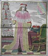 The Holy Roman Empire. "Icon Synoptica Sac. Rom. Imp. Electorum, Du Cum,Principum." Augsburg SEUTTER MATTHÄUS 1734
Copper engraved genealogical plate by Matthäus Seutter from his " Grosser Atlas," Original full colour; verso blank.
The map/portrait is of a symbolic figure of an "Elector" in full robes, which are covered with listings of all rulers of the Holy Roman Empire, princes, electors and dukes.
To the left of the image is an obelisk decorated with heraldic coats of arms; to the right the regalia of Kingship, a crown and sceptre with the throne of State. Dark impression; centrefold split ( approx 40mm) repaired; some light foxing within plate, a few darker spots to right blank margin; ink spot within title; printers crease to lower left margin.
590 by 505mm (23¼ by 20 inches). €800
Scania, Skåne, Southern Sweden.
 A New and Accurate Desrption of Scania, Blekingia And Hallandia. "Descriptio Nova et Accurata Scaniæ, Blekingiæ et Hallandiæ." Augsberg Seutter, Matthäus 1720-40
Copper engraved map of southern Sweden by Matthäus Seutter from his "Atlas Novus". Original colour; verso blank.
The map shows the provinces of Skåne, Halland and Blekinge in southern Sweden, with an inset map of Halland to the lower right corner , Large decorative title cartouche surrounded by winged Victory sounding a trumpet, and a conquering soldier with cannons and guns, a reference to the long history of warfare between the Swedes and Danes over the area. Decorative scale cartouche with coats of arms of the 3 provinces. Good impression; colours bright ; vignettes/cartouches black & white as issued; slight browning to edges and to centrefold from glue of guard to verso; occasional light foxing ;blank margins shortdue to size of plate; old ink number to verso
495 by 577mm (19½ by 22¾ inches). €500
Jerusalem at the time of Christ.
 Jerusalem "Ierusalem, cum suburbiis, prout tempore Christi floruit...juxta designationem Christiani Adrichomii delineata et aeri incisa per Matthaeum Seutter... Abriss der Weltberuehmten Statt Ierusalem.." Augsburg, Lotter, Tobias Conrad, [1741] 1756
Copper engraved plan of Jerusalem at the time of Christ originally from Seutter's "Atlas Novus". Original old colour; verso blank
The map bears the imprint of Tobias Conrad Lotter at the bottom indicating it is from his "Atlas minor. Praecipua orbis terrarum imperia,." 1756 in which he republished maps of his father in law.
An imaginary plan, drawn after Adrichomius. with illustrations of the life of Christ surrounding the city. At the bottom an extensive explanatory text entitled: "Beschreibung der Stadt Ierusalem..." Good dark impression; bright colours.
585 by 497mm (23 by 19½ inches). €1200
Peloponnesus.
 Peloponnesus today Morea... "Peloponnesus hodie Morea.ad normam, veterum et recentiorum maapar accuratissime adornata aeri incisa et venalis exposita per Matth. seutter S.C.M. Geogr. Augustanum." Augsburg, Seutter, Matthäus c 1725-42
Copper engraved map of the Peloponnesus from Seutter's "Atlas Novus". Original old colour; verso blank.
The map shows the whole of the Peloponnesus with the Ionian islands of Levkada, Kephalonia, Ithaka and Zakinthos to the right; Kithera/ Cerigo to the south with the Corinthian and Saronic Gulfs.
Black and white decorative title cartouche depicting the Lion of Venice vanquishing the Turks on the behalf of Christianity, represented by a cross and the cathedral of St. Marks. Good dark impression; very light toning; slight soiling to blank margins.
Zacherakis 3343/2177, [Variant without privilege} 488 by 582mm (19¼ by 23 inches). €750
Cyprus & the Deserts of Egypt and Arabia.
 The Deserts of Egypt , Arabia & Syria with Cyprus. Augsburg, Seutter, Matthäus c 1728-42
Copper engraved map of Cyprus, Egypt and Syria from Seutter's "Atlas Novus". Original old colour; verso blank
The map shows the the Eastern Mediterranean, Cyprus as it lies off the coasts of Egypt, Arabia & Syria. The map is oriented North east with Cyprus at the top centre and the Red Sea also in the centre of the map.
The map is obviously a copy of the map by Sanson/Jaillot , re engraved but with most elements included, even to the pirate ships that appear in the sea off Palestine; the shape of Cyprus is slightly different from the earlier map.
The decorative title cartouche, scale and the compass rose are re engraved. Good dark impression; slight dampstain to lower margin just entering the image at centrefold; lower centrefold split with repair.
Zacherakis 3355 500 by 590mm (19¾ by 23¼ inches). €750
Decorative Map of The British Isles
 The Kingdoms of Anglia, Scotia and Hibernia "Tabula Novissima Accuratissima Regnorum Angliæ, Scotiæ, Hiberniæ." Augsberg Seutter, Matthäus 1720-40
Copper engraved map of the British Isles by Matthäus Seutter from his "Atlas Novus". Original full wash colour; verso blank.
The very decorative map shows the British Isles, with a large title cartouche surmounted by a portrait of the king to upper right; 3 coats of arms of the 3 kingdoms to upper left and decorative scale catouche. Good impression; colours bright ; vignettes/cartouches black & white as issued; left blank margins short; old ink number to verso; paper tab to upper margin.
Shirley: Seutter 1. 575 by 490mm (22¾ by 19¼ inches). €600
The Americas with California as an Island.
 The New World: America North and South with the Kingdoms, Provinces and Islands. "Novus orbis sive America Medionalis et Septentrionalis per sua Regna, Provincias et insulas Juxta Observatioes et Descriptiones Recentis. Divisa et Adornata cura et Opera Matth. seutter Chalc. Aug.". Augsburg, Seutter, Matthäus c 1730
Copper engraved map of the American continent from Seutter's "Atlas Novus". Original old full wash colour; verso blank.
The map,engraved for Seutter by Gottfried Rogg, shows the whole of the Americas, North and South with California as an island. The map has full orignal wash colour designating the kingdoms and provinces; colored lines showing the routes of explorers in the Pacific with the dates of their voyages and a host of other information.
Very large decorative vignettes around title and text to upper and lower left corners. The upper shows 3 Europeans seated with the Madonna above text and native Americans at an alter, thus depicting the arrival of Christianity to the Continent. The lower vignette around the title has a native American monarch possibly Atahualpa surrounded by other natives and exotic fauna, in the background figures, possibly slaves, harvest sugar cane and tobacco. Good dark impression;some soiling mainly to margins; 2 stains in Pacific possibly from wax; slight browning to centrefold; margins short due to size of plate [approx. 10mm to image]; old ink title to verso.
McLaughlin 211; Tooley, 91 p.132. 502 by 582mm (19¾ by 23 inches). €2000
The Island of Corfu.
 Corfu. "Nova et exactissima Geographica Delineatio Insulae Corfu seu Corsulae, tanquam primariae et Clavis maris Ionii cum sinitimis transmarinis Graeciae oppidis et portubus / cura et sumtibus Matthaei Seutteri. . ..". Augsburg, Seutter, Matthäus c 1730-41
Copper engraved map of the island of Corfu/ Kerkyra "Atlas Novus". Original old full wash colour; verso blank.
The plate shows the island of Corfu/Kerkyra and Paxos with the coast opposite. Inset Plan of the town and citadel of Corfu to lower left corner with key to important streets etc; small inset map to upper left showing the position of Corfu, the coast and part of Italy on the Adriatic. Large decorative title vignette surmounted by an angel with Posidon and other figures ; 2 putti, 1 holding a shield depicting the lion of Venice. Good impression; bright colour; some browning at centre fold from guard; very short tear at lower centre fold [10mm] repaired to verso; ink spots to lower blank margin and old ink number to upper right corner; small rust spot to title vignette by putti;.
Zacharakis:3347/2179 500 by 580mm (19¾ by 22¾ inches). €1200
The Hospital Florence Nightingale worked in during the Crimean War.
 Scutari. "Hospital and Cemetry at Scutari." London, Paul and Dominic Colnaghi & Co. 13 & 14 Pall Mall East. Publishers to her Majesty. April 26th 1856.
Tinted lithograph of the hospital and cemetry at Scutari from Simpson's "The Seat of War in the East…"
The view shows the massive Barrack hospital on the ridge, with the British cemetry in the foreground; a funeral is taking place whilst two Muslim grave diggers rest nearby, one praying. There is a small mosque and landing stage on the shore; in the background a glimpse of Istanbul.
The Barrack Hospital at Scutari,was Florence Nightingale's base during the Crimean War; Scutari was the Greek name for the district of Istanbul now known as Üsküdar located on the Asian shore of the Bosphorus right opposite the peninsula of Stamboul. Tinted lithograph, generally bright; minor light spotting to blank margins; dark water stain to upper edge 15mm from image [can be covered by mount.]
Abbey Travel 237. 313 by 467mm (12¼ by 18½ inches) Image without title; 370x555mm size of page. €300
Paulus Stephanus' Sophocles.
 ΣΟΠΦΟΚΛΕΟΥΣ ΑΙ ΕΠΤΣ ΤΡΑΓΩΔΙΑ. Sophoclis Tragoediæ Septem. una cum omnibus Græcis scholis, & Latina Viti Winsemi ad verbum Interpretatione. Quibus accessserunt Ioachimi Cameranij, necnon Henrici Stephani annotationes..., Geneva(Coloniæ Allobrogum) Excudebat Paulus Stephanus (Paul Estienne). 1603
Quarto: [4] 788p [16] 5p. 202p.[ 3]. 4 parts in 1 volume. Contemporary Vellum.
This edition, together with that of Euripides (1602) are considered to be the major printing achievements of Paul Stephanos.
"This is not a reprint of Henri's edition of 1578, but a much improved work: besides the commentaries of Camerarius, it includes the Annotations of Henri Estienne, which were not found in the earlier edition,( the) scholia of Triclinios and the Latin translation of Vitus Winsemius (Veit Oertel) "(Schreiber 273).
The dedicatory Epistle is by Paul Estienne. - Contains the sameworks as the previous edition. The scholia that accompany the text of each tragedy have the same starting title as in the edition of Henri Estienne of 1568. The following metric notes of Triclinius are not paginated. - The "Annotationes" of Henri Estienne and the "Commentatio" by Joachim Camerarius each have a title and particular pagination. Repair to head and foot of spine replacing portion of contemporary vellum; small loss of vellum to front board; stains; corners bumped; 2 worm holes to vellum of rear board.
Last 2 leaves [pages 49 &51] of Annotationes Henri Stephani misbound between Lllll1 and Lllll2 of the scholia of Tricliinios.
Poor quality 16th century paper [as usual], causing browning throughout, worse to rear; damp stain at lower gutter throughout;
lacks free endpapers.
Excised [inked over] ownership names to title[ stain continues on next page]; 4 holes to gutter of title page becoming 1 hole to first leaf of prelims.
Tear to margin of page 3 (Aii) just touching letter; occasional paper faults including lack of paper in margin as a result of the poor quality paper.
Hoffmann III, 415 • Renouard, Annales, 196 (12) • Schreiber, 220-21 (273) 240 by 170mm (9½ by 6¾ inches). €2000
Company: Bryan, Mary Louise.
Address: Ag. Andrianoy 92 , 21 100 Nafplio, Greece.
Vat No: EL 119092581