MAPS & VIEWS
PRINTS
BOOKS
The Oracle of Delphi.
 Baron de Stackelberg del . Justin Ouvrie lith.
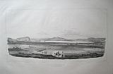
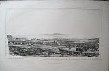
A General View of Delphi. "Vue Genérale de Delphes" Paris J.F. d'Ostervald 1829-1834
Baron de Stackelberg del . Justin Ouvrie lith.
A General View of Delphi. "Vue Genérale de Delphes" Paris J.F. d'Ostervald 1829-1834Black & white lithograph of the site of Delphi from Stackelberg's " La Grèce. Vues Pitttoresques et Topographiques." First and only edition: double page from an unfolded edition; blank verso.
The view shows the village of Kastri which stood on what is now the archeological site; the residents had used the marble columns and structures as support beams and roofs for their improvised houses.
Stackelberg indicates the temple of Apollo within the village, also giving locations for the Stadium and other major structures. although the site would not be excavated until the end of the century, when the village was moved following an earthquake. Behind is the rising might of Mount Parnassus, with Arachova on its high slopes. Generally clean & bright; 3 tiny wormhole withiin sky of the image; short tears to extreme margins well away from the image.
Navari/ Blackmer: 1593; Sotheby's/Blackmer 1031 415 by 660mm (16¼ by 26 inches) image including title. €700
Mount Taygetos and Sparta, Peloponnesus.
 Baron de Stackelberg del. Le Camus lith.
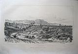
Chain of Taygetos, and the theatre at Sparta. "Chaine du Taygète. Vue de Thèatre de Sparte." Paris J.F. d'Ostervald 1829-1834
Baron de Stackelberg del. Le Camus lith.
Chain of Taygetos, and the theatre at Sparta. "Chaine du Taygète. Vue de Thèatre de Sparte." Paris J.F. d'Ostervald 1829-1834Black & white lithograph of Mount Taygetos, Sparti and Mystras from Stackelberg's " La Grèce. Vues Pitttoresques et Topographiques." First and only edition: double page folded; blank verso.
The view is from the ancient theatre of Sparta, in the valley of Evrotas, looking towards Taygatos, showing Mystras on the slopes. Evenly toned.; a few spots to sky ; the rest mainly to blank margins.
Navari/ Blackmer: 1593; Sotheby's/Blackmer 1031 350 by 647mm (13¾ by 25½ inches)image including title. €1000
Panopea & Chæronia, Boeotia, Continental Greece.
 Baron de Stackelberg del . Villeneuve Lith.
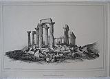
Chæronia. "Ruines de Panopée et Plaine de Chæronée" Paris J.F. d'Ostervald 1829-1834
Baron de Stackelberg del . Villeneuve Lith.
Chæronia. "Ruines de Panopée et Plaine de Chæronée" Paris J.F. d'Ostervald 1829-1834Black & white lithograph of the ruins of the ancient town of Panopea above the plain of Chæronia. from Stackelberg's " La Grèce. Vues Pitttoresques et Topographiques." First and only edition: single page; blank verso.
Pausanius describing the remains of Panopea wonders iftit could be considered a city as it has "neither governor, nor a gymnasium, nor a theatre, nor a forum, nor, lastly any fountain of water."
He goes on to comment that the inhabitabts lived in "wooden houses, resembling cottages in the mountains." and concludes that it must have been more stronghold than a city. Evenly toned; very minor spotting.
Navari/ Blackmer: 1593; Sotheby's/Blackmer 1031 280 by 394mm (11 by 15½ inches) image including title. €100
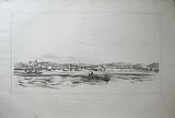
Patras , Entrance to the Gulf of Corinth & the coast of Ætolia.
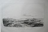
 Coast of Ætolia, View of Patras. "Cõtes de Ætolie vue de Patras." Paris J.F. d'Ostervald 1829-1834
Black & white lithograph of the entrance to the gulf of Korinth, with Patras from Stackelberg's " La Grèce. Vues Pitttoresques et Topographiques." First and only edition: double page folded; blank verso.
The view shows the entrance to the Gulf of Korinth with the small town of Patras in the foreground, looking across to the coast of Ætolia opposite. Spotting mainly to margins.
Navari/ Blackmer: 1593; Sotheby's/Blackmer 1031 375 by 660mm (14¾ by 26 inches)image including title. €800
View from the Euripus Strait to Chalkis, Euboea,
 Baron de Stackelberg del. Jaime Lith.
Euripos today called Negropont. "Egripos aujourd'hui Nègropont.." Paris J.F. d'Ostervald 1829-1834
Baron de Stackelberg del. Jaime Lith.
Euripos today called Negropont. "Egripos aujourd'hui Nègropont.." Paris J.F. d'Ostervald 1829-1834Black & white lithograph of the Chalkis Euboea from Stackelberg's " La Grèce. Vues Pitttoresques et Topographiques." First and only edition: double page from an unfolded edition; blank verso.
The view shows the town of Chalkis from the Euripos Strait, showing the walls of the town and the Euripos bridge linking the island to the mainland across the narrow strait . Clean and bright; one spot to image; unobtrusive adhesion marks to upper right margin just entering image; tear to lower margin [45mm] far from image; chips to left margin edge.
Navari/ Blackmer: 1593; Sotheby's/Blackmer 1031 370 by 625mm (14½ by 24½ inches)image including title. €1200
The Hanging Monasteries of Meteora. Thessaly.
 Baron de Stackelberg del . Villeneuve Lith.
General view of Meteora, Kalambaka, and the monasteries . "Vue Général des Météores; Monastéres sur le Pinde ." Paris J.F. d'Ostervald 1829-1834
Baron de Stackelberg del . Villeneuve Lith.
General view of Meteora, Kalambaka, and the monasteries . "Vue Général des Météores; Monastéres sur le Pinde ." Paris J.F. d'Ostervald 1829-1834Black & white lithograph of the monasteries of Meteora with a view of Kalmbaka from Stackelberg's " La Grèce. Vues Pitttoresques et Topographiques." First and only edition: single page; blank verso.
Meteora is one of the largest and most important complexes of Eastern Orthodox monasteries in Greece, second only to Mount Athos; in the 9th century, an ascetic group of hermit monks moved up to the ancient pinnacles.
The exact date of the establishment of the monasteries is unknown. By the late 11th and early 12th centuries, a rudimentary monastic state had formed called the Skete of Stagoi and was centered around the still-standing church of Theotokos (mother of God).[1] By the end of the 12th century, an ascetic community had flocked to Metéora. Generally clean; some spotting to margins, a few light spots to image.
Navari/ Blackmer: 1593; Sotheby's/Blackmer 1031 285 by 407mm (11¼ by 16 inches) image including title. €500
Gyrton,on the river Pineios, Thessaly.
 Baron de Stackelberg del . Villeneuve Lith.
Gyrton in the valley of the Pineios. "Gyrton dans le Vallèe du Pènèe." Paris J.F. d'Ostervald 1829-1834
Baron de Stackelberg del . Villeneuve Lith.
Gyrton in the valley of the Pineios. "Gyrton dans le Vallèe du Pènèe." Paris J.F. d'Ostervald 1829-1834Black & white lithograph of the Gyrton & the valley of the Pineois, Thessaly from Stackelberg's " La Grèce. Vues Pitttoresques et Topographiques." First and only edition: double page from an unfolded edition; blank verso.
The view shows the course of the river in the valley with the mountains including olympus behind . gyrton is a small village on the river named after a mythological figure. Clean and bright; printed on india paper, mounted;some spotting to margins; chips to extreme edges of paper.
Navari/ Blackmer: 1593; Sotheby's/Blackmer 1031 365 by 586mm (14¼ by 23 inches)India paper. €700
Gyrton,on the river Pineios, Thessaly.
 Baron de Stackelberg del . Villeneuve Lith.
Gyrton in the valley of the Pineios. "Gyrton dans le Vallèe du Pènèe." Paris J.F. d'Ostervald 1829-1834
Baron de Stackelberg del . Villeneuve Lith.
Gyrton in the valley of the Pineios. "Gyrton dans le Vallèe du Pènèe." Paris J.F. d'Ostervald 1829-1834Lithograph of the Gyrton & the valley of the Pineois, Thessaly from Stackelberg's " La Grèce. Vues Pitttoresques et Topographiques." First and only edition: double page from an unfolded edition; Modern colour; blank verso.
The view shows the course of the river in the valley with the mountains including olympus behind . gyrton is a small village on the river named after a mythological figure. Spot to sky; some spotting to margins.
Navari/ Blackmer: 1593; Sotheby's/Blackmer 1031 350 by 565mm (13¾ by 22¼ inches)Image including title. €500
Messolonghi, Aetolia-Acarnania.
 Baron de Stackelberg del . Villeneuve Lith.
Messolonghi. "Messalonghi." Paris J.F. d'Ostervald 1829-1834
Baron de Stackelberg del . Villeneuve Lith.
Messolonghi. "Messalonghi." Paris J.F. d'Ostervald 1829-1834Black & white lithograph of Mesalonghi from Stackelberg's " La Grèce. Vues Pitttoresques et Topographiques." First and only edition: single page; blank verso.
The view shows the town from the marshes with the mountains behind. This is probably one of the few views of the whole town, famous for the seige there during the war of Independence and where Lord Byron met his death. Bright and generally clean; one spot within the image, lower left corner; wide margins, some chips to edges .
Navari/ Blackmer: 1593; Sotheby's/Blackmer 1031 230 by 396mm (9 by 15½ inches) image including title. €600
Methoni, Messenia, Peloponnesus.
 Dedreux del. Lithog par St.Aulaire.
Methoni. "Mothone (Modon)." Paris J.F. d'Ostervald 1829-1834
Dedreux del. Lithog par St.Aulaire.
Methoni. "Mothone (Modon)." Paris J.F. d'Ostervald 1829-1834Black & white lithograph of Methoni from Stackelberg's " La Grèce. Vues Pitttoresques et Topographiques." First and only edition: single page; blank verso.
The view shows the town from the sea clearly showing the fortifications. Generally clean; some spotting to margins, a few light spots to image; tear to upper blank margin repaired.
Navari/ Blackmer: 1593; Sotheby's/Blackmer 1031 235 by 399mm (9¼ by 15¾ inches) image including title. €600
Mount Oros on the island of Ægina in the Saronic Gulf.
 Baron de Stackelberg del . Villeneuve Lith.
Mount Oros, Ægina "Intérieur du mont Fendu à Egine." Paris J.F. d'Ostervald 1829-1834
Baron de Stackelberg del . Villeneuve Lith.
Mount Oros, Ægina "Intérieur du mont Fendu à Egine." Paris J.F. d'Ostervald 1829-1834Black & white lithograph of Mount Oros in the interior of Ægina from Stackelberg's " La Grèce. Vues Pitttoresques et Topographiques." First and only edition: single page; blank verso.
Baedeker in 1894 states: "the Oros,now named St.Elias after a chapel on its summit, is the most conspicuous point in the entire Saronic gulfand attracts the eye of every traveller who sails across the gulf from the E.or S."
Toning to edges of paper, a few spots to margins, otherwise clean.
Navari/ Blackmer: 1593; Sotheby's/Blackmer 1031 285 by 396mm (11¼ by 15½ inches) image including title. €200
Nafplion, First Capital of Modern Greece.
 Baron de Stackelberg del . Jacollet Lith.
Napoli di Romaine otherwise Nafplion. "Napoli de Romainie autrefois Naùplie." Paris J.F. d'Ostervald 1829-1834
Baron de Stackelberg del . Jacollet Lith.
Napoli di Romaine otherwise Nafplion. "Napoli de Romainie autrefois Naùplie." Paris J.F. d'Ostervald 1829-1834Black & white lithograph of Nafplion and the approach across the plain of Argos from Stackelberg's " La Grèce. Vues Pitttoresques et Topographiques." First and only edition: double page from an unfolded edition; blank verso.
The view from the plain of Argos also shows Tyrins , the rock of Palamidi , Acronafplia, and Bourdgi in the gulf of Argos. On the opposite shore Stackelberg indicates Lerna home of the Hydra killed by Hercules as the 2nd of his 12 labours. Bright & clean; some very light spotting within the image and to the blank margins.
Navari/ Blackmer: 1593; Sotheby's/Blackmer 1031 375 by 645mm (14¾ by 25½ inches)image including title. €800
Kalamata, Messinia, Peloponnesus.
 Baron de Stackelberg del . Lit-é par Villeneuve
Pharae today called Calamata. "Pharae aujourd'hui Calamata" Paris J.F. d'Ostervald 1829-1834
Baron de Stackelberg del . Lit-é par Villeneuve
Pharae today called Calamata. "Pharae aujourd'hui Calamata" Paris J.F. d'Ostervald 1829-1834Black & white lithograph of Kalamata from Stackelberg's " La Grèce. Vues Pitttoresques et Topographiques." First and only edition: double page from an unfolded edition; blank verso.
The view shows the castle, site of the ancient city of Pharae and the town of Kalamata extending down to the sea. the chain of Taygetus in the background. Evenly toned.
Navari/ Blackmer: 1593; Sotheby's/Blackmer 1031 390 by 643mm (15¼ by 25¼ inches)image including title. €1200
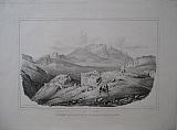
The Fort of Phyle, Attika.
 Baron de Stackelberg del .Tirpenne lithog.
Phyle. "Phylès" Paris J.F. d'Ostervald 1829-1834
Baron de Stackelberg del .Tirpenne lithog.
Phyle. "Phylès" Paris J.F. d'Ostervald 1829-1834Black & white lithograph of the fort of Phyle Attika from Stackelberg's " La Grèce. Vues Pitttoresques et Topographiques." First and only edition: double page from an unfolded edition; blank verso.
The view shows the Athenian Phyle frontier fort, part of a chain of forts on Attika's northern border, which lies against the Parnes Mountains and protects one of the passes towards Thebe. The viewlooks over
the plain of Eleusis and in the far distance the Acropolis of Athens is marked by Stackelberg. Clean & bright.
Navari/ Blackmer: 1593; Sotheby's/Blackmer 1031 405 by 672mm (16 by 26½ inches)Image including title. €500
The Island of Salamína, site of the Battle of Salamis
 Baron de Stackelberg del . Jacollet Lith.
Salamina. "Salamine." Paris J.F. d'Ostervald 1829-1834
Baron de Stackelberg del . Jacollet Lith.
Salamina. "Salamine." Paris J.F. d'Ostervald 1829-1834Black & white lithograph of the island of Salamina from Stackelberg's " La Grèce. Vues Pitttoresques et Topographiques." First and only edition: double page from an unfolded edition; blank verso.
The view shows the island of Salamina from behind the village of Ampelaka , with indications of the sites of the ancient town of Salamina, the port and looking to the mainland, in the distance the Acropolis of Athens .
Stackelberg must have chosen this view as it also shows the site of the Battle of Salamis , between the island and the mainland. Clean & bright.
Navari/ Blackmer: 1593; Sotheby's/Blackmer 1031 3000 by 658mm (118 by 26 inches)image including title. €800
Valley of Tempe, Thessaly, Northern Greece.
 Baron de Stackelberg del . Villeneuve Lith.
Tempe. "Gonnus dans les défilés de Tempé" Paris J.F. d'Ostervald 1829-1834
Baron de Stackelberg del . Villeneuve Lith.
Tempe. "Gonnus dans les défilés de Tempé" Paris J.F. d'Ostervald 1829-1834Black & white lithograph of the fort of Gonnus above the valley of Tempe from Stackelberg's " La Grèce. Vues Pitttoresques et Topographiques." First and only edition: single page; blank verso.
John Lemprière in his Classical Dictionary gives this description: "Tempe, (plur.) a valley in Thessaly, between mount Olympus at the north, and Ossa at the south, through which the river Peneus flows into the Ægean. The poets have described it as the most delightful spot on the earth, with continual cooling shades, and verdant walks, which the warbling of birds rendered more pleasant and romantic, and which the gods often honored with their presence. Tempe extended about five miles in length but varied in the dimensions of its breadth so as to be in some places scarce one acre and a half wide. All vallies that are pleasant, either for their situation or the mildness of their climate, are called Tempe by the poets."
Printed on india paper, mounted, generally clean; spotting to verso not showing on image; a few spots to lower image.
Navari/ Blackmer: 1593; Sotheby's/Blackmer 1031 285 by 395mm (11¼ by 15½ inches) image including title. €250
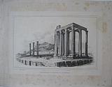
Temple of Minerva, Ægina in the Saronic Gulf.
 Baron de Stackelberg del.; Chapuy lithog.; Fig par v. Adam.
Temple of Aphaea, Ægina. "Temple de Minerve à Egine." Paris J.F. d'Ostervald 1829-1834
Baron de Stackelberg del.; Chapuy lithog.; Fig par v. Adam.
Temple of Aphaea, Ægina. "Temple de Minerve à Egine." Paris J.F. d'Ostervald 1829-1834Black & white lithograph of the Temple of Minerva on Ægina from Stackelberg's " La Grèce. Vues Pitttoresques et Topographiques." First and only edition: single page; blank verso.
Also known as the Temple of Aphaea,the temple was made known in Western Europe by the publication of the Antiquities of Ionia (London, 1797). In 1811, the young English architect Charles Robert Cockerell, finishing his education on his academic Grand Tour, and Baron Otto Magnus von Stackelberg removed the fallen fragmentary pediment sculptures. On the recommendation of Baron Carl Haller von Hallerstein, who was also an architect and, moreover, a protégé of the art patron Crown Prince Ludwig of Bavaria, the marbles were shipped abroad and sold the following year to the Crown Prince, soon to be King Ludwig I of Bavaria. Printed on india paper, mounted: scratch to sky ; generally clean; spotting to verso not showing on image; a few spots to lower margin; short margins, approx6mm outside printed image.
Navari/ Blackmer: 1593; Sotheby's/Blackmer 1031 297 by 400mm (11¾ by 15¾ inches) image including title. €500
Temple of Zeus, Ancient Nemea.
 Baron de Stackelberg del . Villeneuve Lith.
Temple of Zeus Nemea. "Temple de jupiter Néméen." Paris J.F. d'Ostervald 1829-1834
Baron de Stackelberg del . Villeneuve Lith.
Temple of Zeus Nemea. "Temple de jupiter Néméen." Paris J.F. d'Ostervald 1829-1834Black & white lithograph of the Temple of Zeus, Ancient Nemea from Stackelberg's " La Grèce. Vues Pitttoresques et Topographiques." First and only edition: single page; blank verso. Bright and generally clean; one spot within the image,; wide margins, dampstain to lower right corner far from image.
Navari/ Blackmer: 1593; Sotheby's/Blackmer 1031 235 by 393mm (9¼ by 15½ inches), Image within border title below. page size:365x492mm. €380
Temple of Zeus, Ancient Nemea.
Baron de Stackelberg del . Villeneuve Lith. Temple of Zeus Nemea. "Temple de jupiter Néméen." Paris J.F. d'Ostervald 1829-1834Black & white lithograph of the Temple of Zeus, Ancient Nemea from Stackelberg's " La Grèce. Vues Pitttoresques et Topographiques." First and only edition: single page; blank verso. Bright,light spotting/ foxing mainly to blank margins, a few within image; wide margins.
Navari/ Blackmer: 1593; Sotheby's/Blackmer 1031 235 by 393mm (9¼ by 15½ inches), Image within border title below. page size:365x492mm. €380
Ancient Sparta, Mount Taygetos, Peloponnesus.
 Baron de Stackelberg del . Lithog. par Dupressoir
The Acropolis of Sparta. "Acropolis de Sparte." Paris J.F. d'Ostervald 1829-1834
Baron de Stackelberg del . Lithog. par Dupressoir
The Acropolis of Sparta. "Acropolis de Sparte." Paris J.F. d'Ostervald 1829-1834Black & white lithograph of the acropolis of Ancient Sparti, Mystras and Mount Taygetos from Stackelberg's " La Grèce. Vues Pitttoresques et Topographiques." First and only edition: double page from an unfolded edition; blank verso.
The view looks up the valley of Evrotas, showing the acropolis of Ancient Sparta, with the Theatre , also showing the position of Mystras on the slopes of Mount Taygetos. In the foreground various figures rest amongst ruined columns. Clean & bright; some light small spots.
Navari/ Blackmer: 1593; Sotheby's/Blackmer 1031 365 by 630mm (14¼ by 24¾ inches)image including title. €1000
A view of the Ancient Agora, Korinth.
 Baron de Stackelberg delt.; Lith. par Gaverini.
The Ancient Agora of Corinth. "L'Ancienne Agora de Corinth." Paris J.F. d'Ostervald 1829-1834
Baron de Stackelberg delt.; Lith. par Gaverini.
The Ancient Agora of Corinth. "L'Ancienne Agora de Corinth." Paris J.F. d'Ostervald 1829-1834Black & white lithograph of the ancient agora at Corinth with AcroCorinth in the background from Stackelberg's " La Grèce. Vues Pitttoresques et Topographiques." First and only edition: single page; blank verso.
The view shows the settlement at Corinth with the temple of Apollo and the archeological site to the rear; the whole is overlooked by AcroCorinth . Printed on india paper, mounted: sevenly toned, dampstaining to upper margins, entering image upper right .
Navari/ Blackmer: 1593; Sotheby's/Blackmer 1031 264 by 420mm (10½ by 16½ inches) extent of india paper, image Including title. €650
The Port of Ægina.
 Baron de Stackelberg del . Rose Ostervald lith.
The Great Portof Ægina and the ruins of the Temple of Venus. "Grand Port d'Egine et Restes de Temple de Venus" Paris J.F. d'Ostervald 1829-1834
Baron de Stackelberg del . Rose Ostervald lith.
The Great Portof Ægina and the ruins of the Temple of Venus. "Grand Port d'Egine et Restes de Temple de Venus" Paris J.F. d'Ostervald 1829-1834Black & white lithograph of the port of Ægina, from Stackelberg's " La Grèce. Vues Pitttoresques et Topographiques." First and only edition: double page from an unfolded edition; blank verso.
The view shows the port of Ægina, with the town, and the remains of the Temple of Venus. Clean & bright; slight crease to centre of sky; a few tears repaired to edges of paper; spotting to blank margins.
Navari/ Blackmer: 1593; Sotheby's/Blackmer 1031 390 by 640mm (15¼ by 25¼ inches))image including title. €1000
Temple of Olympian Zeus & the Acropolis, Athens.
 Baron de Stackelberg del.; Lith. par Benoit
The Olympieion called by the Romans the Temple of Jupiter Olympius, known in the eighteenth century as the Columns of Hadrian. "Pantheon d'Adrien a Athènes." Paris J.F. d'Ostervald 1829-1834
Baron de Stackelberg del.; Lith. par Benoit
The Olympieion called by the Romans the Temple of Jupiter Olympius, known in the eighteenth century as the Columns of Hadrian. "Pantheon d'Adrien a Athènes." Paris J.F. d'Ostervald 1829-1834Black & white lithograph of the temple of Olympian Zeus, Athens from Stackelberg's " La Grèce. Vues Pitttoresques et Topographiques." First and only edition: single page; blank verso.
The view shows the temple in the foreground in great detail, with the Acropolis behind; the perspective also allows one to see the Gate of Hadrien and the Theatre of Herodian.
An iconic image of Athens;the temple is described by Vitruvius:"This work is not only universally esteemed, but is accounted one of the rarest specimens of magnificence."[ "On Architecture"(VII.Pref.15)]
Printed on india paper, mounted: spotting to sky & heavier to blank margins.
Navari/ Blackmer: 1593; Sotheby's/Blackmer 1031 310 by 455mm (12¼ by 18 inches)extent of india paper, image Including title. €1000
The Lion gate of Mycenae, Peloponnesus
 Baron de Stackelberg del . Lithog par Broulloff.
The Plain of Argos and Mycenae. "Plaine d'Argos et de Mycène." Paris J.F. d'Ostervald 1829-1834
Baron de Stackelberg del . Lithog par Broulloff.
The Plain of Argos and Mycenae. "Plaine d'Argos et de Mycène." Paris J.F. d'Ostervald 1829-1834Lithograph of the Lion gate of Mycenae and the plain of Argos from Stackelberg's " La Grèce. Vues Pitttoresques et Topographiques." First and only edition: double page from an unfolded edition; modern colour; blank verso.
The view shows the famous entry to the acropolis of Mycenae, the Lion Gate ,and looks over the Plain of Argos to the castle of Larissa, Argos with Nafplion in the distance .
The gate is unexcavated; in the foreground are various figures including the artist making a sketch of the gate; on the approach to the gate another group of figures, stand before the "trésor souterraine" as indicated by Stackelberg. The view is important in showing the archeological features before excavation which was first carried out by the Greek archaeologist Kyriakos Pittakis in 1841. He found and restored the Lion Gate. In 1876, Heinrich Schliemann started a complete excavation at the site. Bright & clean; some minor spotting to blank margins; upper corners with old repairs.
Navari/ Blackmer: 1593; Sotheby's/Blackmer 1031 360 by 650mm (14¼ by 25½ inches)image including title. €800
Mystras, Byzantine capital of the Despotate of the Morea.
 Baron de Stackelberg del.; Lith. par Deroy.
The Plain of Evrotas , View of Mystras. "Plaine d'Evrotas. Vue de Mistra." Paris J.F. d'Ostervald 1829-1834
Baron de Stackelberg del.; Lith. par Deroy.
The Plain of Evrotas , View of Mystras. "Plaine d'Evrotas. Vue de Mistra." Paris J.F. d'Ostervald 1829-1834Black & white lithograph of Mystras from Stackelberg's " La Grèce. Vues Pitttoresques et Topographiques." First and only edition: double page from an unfolded edition; blank verso.
Mystras was the capital of the Byzantine Despotate of the Morea in the 14th and 15th centuries. The view is from close to the city & looks down the valley of the Evrotas river, with the Acropolis of Ancient Sparta in the distance Clean & bright.
Navari/ Blackmer: 1593; Sotheby's/Blackmer 1031 365 by 615mm (14¼ by 24¼ inches)image including title. €1200
Athens from the Plain of Kifissós,
 Baron de Stackelberg del . Justin Ouvrie Lith.
The Plain of Kifissós, "Plain de Céphisse." Paris J.F. d'Ostervald 1829-1834
Baron de Stackelberg del . Justin Ouvrie Lith.
The Plain of Kifissós, "Plain de Céphisse." Paris J.F. d'Ostervald 1829-1834Black & white lithograph of Athens from the Plain of Kifissós,, from Stackelberg's " La Grèce. Vues Pitttoresques et Topographiques." First and only edition: double page from an unfolded edition; blank verso.
The view shows the plain of the river Kifissós, with the Acropolis of Athens in the mid ground and extending to the sea and the port of Pireus, Clean & bright; tears to right margin repaired [longest 40mm top right corner] none of the tears enters the image.
Navari/ Blackmer: 1593; Sotheby's/Blackmer 1031 380 by 662mm (15 by 26 inches)image including title. €1500
View of the Citadel of Zakinthos / Zante.
 Baron de Stackelberg del.; Lith. par Deroy.
The Plain of Zakinthos or Zante. "Plaine de Zacinthe ou Zante" Paris J.F. d'Ostervald 1829-1834
Baron de Stackelberg del.; Lith. par Deroy.
The Plain of Zakinthos or Zante. "Plaine de Zacinthe ou Zante" Paris J.F. d'Ostervald 1829-1834Lithograph of the Citadel of Zakinthos from Stackelberg's " La Grèce. Vues Pitttoresques et Topographiques." First and only edition: double page from an unfolded edition; modern colour; blank verso.
The view shows the Venetian citadel on Mount Bochali, from the the plain within the island looking towards the sea and the promontory of Keri Light toning to blank margins.
Navari/ Blackmer: 1593; Sotheby's/Blackmer 1031 370 by 597mm (14½ by 23½ inches).image including title. €700
View of the Citadel of Zakinthos / Zante.
 Baron de Stackelberg del.; Lith. par Deroy.
The Plain of Zakinthos or Zante. "Plaine de Zacinthe ou Zante" Paris J.F. d'Ostervald 1829-1834
Baron de Stackelberg del.; Lith. par Deroy.
The Plain of Zakinthos or Zante. "Plaine de Zacinthe ou Zante" Paris J.F. d'Ostervald 1829-1834Black & white lithograph of the Citadel of Zakinthos from Stackelberg's " La Grèce. Vues Pitttoresques et Topographiques." First and only edition: double page from an unfolded edition; blank verso.
The view shows the Venetian citadel on Mount Bochali, from the the plain within the island looking towards the sea and the promontory of Keri Light spotting over image and margins.
Navari/ Blackmer: 1593; Sotheby's/Blackmer 1031 370 by 597mm (14½ by 23½ inches)image including title. €800
The Old City of Korinth, and Acrokorinth. Peloponnesus
 Baron de Stackelberg del . Lithog. par Dupressoir
The Town of Corinth , close to the port of Lechaeum . "Ville de Corinth, prise du port Lèuchèum." Paris J.F. d'Ostervald 1829-1834
Baron de Stackelberg del . Lithog. par Dupressoir
The Town of Corinth , close to the port of Lechaeum . "Ville de Corinth, prise du port Lèuchèum." Paris J.F. d'Ostervald 1829-1834Black & white lithograph of Korinth, the old city, and Acrokorinth from Stackelberg's " La Grèce. Vues Pitttoresques et Topographiques." First and only edition: double page from an unfolded edition; blank verso.
The view shows the old city of Korinth around the precincts of Ancient Korinth on the slopes of the rock of Acrokorinth, and mentions the port of Lechaeum close to which the modern city was built after the earthquake of1858.
Stackelberg indicates the palace of the Pascha (under Ottoman rule Corinth was the capital of the Mora Eyalet in 1715–1731 and then a sanjak capital until 1821) Bright & clean.
Navari/ Blackmer: 1593; Sotheby's/Blackmer 1031 370 by 628mm (14½ by 24¾ inches)image including title. €1200
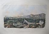
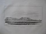
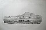
The course of the river Pineios , Mounts Ossa & Olympus, Northern Greece.
 Baron de Stackelberg del . Villeneuve Lith.
The Valley between Mounts Ossa & Olympus. "Vallée entre les Monts Ossa et Olympe." Paris J.F. d'Ostervald 1829-1834
Baron de Stackelberg del . Villeneuve Lith.
The Valley between Mounts Ossa & Olympus. "Vallée entre les Monts Ossa et Olympe." Paris J.F. d'Ostervald 1829-1834Black & white lithograph of the course of the river Pinieos between Mounts Ossa & Olympus in Northern Greece from Stackelberg's " La Grèce. Vues Pitttoresques et Topographiques." First and only edition: single page; blank verso.
The plate shows the whole valley with the mountains to either side ; the village Baba is shown in the foreground. Printed on india paper, mounted: scratch to sky ; generally clean; spotting to verso not showing on image; a few spots to lower margin.
Navari/ Blackmer: 1593; Sotheby's/Blackmer 1031 260 by 393mm (10¼ by 15½ inches) image including title. €250
Company: Bryan, Mary Louise.
Address: Ag. Andrianoy 92 , 21 100 Nafplio, Greece.
Vat No: EL 119092581