MAPS & VIEWS
PRINTS
BOOKS
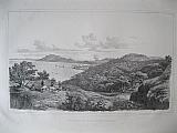
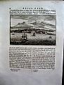
Dancing in Zakinthos. View of the town of Zante.
 Baron de Stackelberg del.; Lith. par Deroy.
Town & Port of Zakinthos (Zante). "Ville et Port de Zacinthe ( Zante)." Paris J.F. d'Ostervald 1829-1834
Baron de Stackelberg del.; Lith. par Deroy.
Town & Port of Zakinthos (Zante). "Ville et Port de Zacinthe ( Zante)." Paris J.F. d'Ostervald 1829-1834Black & white lithograph of the port and town of Zakinthos from Stackelberg's " La Grèce. Vues Pitttoresques et Topographiques." First and only edition: double page from an unfolded edition; blank verso.
The view shows the town and port of Zakinthos, with the Venetian citadel, on Mount Bochali, above the city; in the foreground a group of islanders dance. Generally bright , but some spotting to sky, some larger; spotting to blank margins.
Navari/ Blackmer: 1593; Sotheby's/Blackmer 1031 410 by 620mm (16¼ by 24½ inches)image including title. €1200
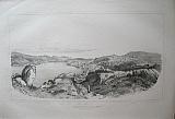
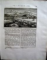
Town & Port of Poros, Saronic Gulf.
 Baron de Stackelberg del . Lit-é par Villeneuve
Troizinia and the Isle of Kalavria now called Poros. "Trœzène et Ile de Calaurie, aujourd'hui Poros." Paris J.F. d'Ostervald 1829-1834
Baron de Stackelberg del . Lit-é par Villeneuve
Troizinia and the Isle of Kalavria now called Poros. "Trœzène et Ile de Calaurie, aujourd'hui Poros." Paris J.F. d'Ostervald 1829-1834Black & white lithograph of Poros Town on the Island of Poros from Stackelberg's " La Grèce. Vues Pitttoresques et Topographiques." First and only edition: double page from an unfolded edition; blank verso.
The view shows the port and town of Poros on Sphairia with the Isle of Kalavria in the background and looks across to Troizinia on the mainland . (Sphairia and Kalavria are the pair of islands which together are known as Poros). Bright , but some light spotting to image; spotting to blank margins.
Navari/ Blackmer: 1593; Sotheby's/Blackmer 1031 403 by 645mm (15¾ by 25½ inches)image including title. €1200
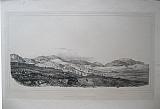
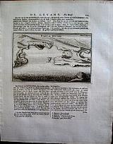
Ancient Nemea.
 Baron de Stackelberg del . Villeneuve Lith.
Valley of Nemea. "Valée de Némée." Paris J.F. d'Ostervald 1829-1834
Baron de Stackelberg del . Villeneuve Lith.
Valley of Nemea. "Valée de Némée." Paris J.F. d'Ostervald 1829-1834Black & white lithograph of the valley of Nemea from Stackelberg's " La Grèce. Vues Pitttoresques et Topographiques." First and only edition: single page; blank verso.
A distant view of the temple of Zeus in the Valley of Nemea. Even light toning; spinkling oflight foxing with a few darker spots to blank margins.
Navari/ Blackmer: 1593; Sotheby's/Blackmer 1031 224 by 403mm (8¾ by 15¾ inches) image within border, title and key below. page size;370x506mm €250
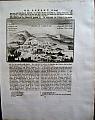
Livadeia, Capital of Boeotia.
 Baron de Stackelberg del . Justin Ouvrie lith.
View of Livadeia Boeotia. "Lébadée aujourd'hui Livadie." Paris J.F. d'Ostervald 1829-1834
Baron de Stackelberg del . Justin Ouvrie lith.
View of Livadeia Boeotia. "Lébadée aujourd'hui Livadie." Paris J.F. d'Ostervald 1829-1834Black & white lithograph of the Livadia from Stackelberg's " La Grèce. Vues Pitttoresques et Topographiques." First and only edition: double page from an unfolded edition; blank verso.
Possibly the best view of Livadeia, showing its position on the slopes above the plain built between two hills the 2 springs known in mythology as "Lethe" (forgetfulness) and "Mnemosyne" (memory).
Stackelberg marks the Oracle of Trophonius and the mountains Parnassus and Cirphis . Clean and bright; printed on india paper, mounted; small scratch to sky; chips to extreme edges of paper.
Navari/ Blackmer: 1593; Sotheby's/Blackmer 1031 390 by 670mm (15¼ by 26½ inches) india paper. €1000
Lisbon the Capital of Portugal.
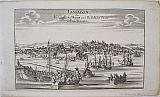 Lisbon "Lissabon die Königlichte Haupt und Residenz Statt in Portugall." Augsburg Stridbeck, Johann c1700
Copper engraved view of Lisbon,from Johann Stridbeck's "Curiosen Staats und Kriegs Theatrums"Black & white as published.
The view shows the city from the sea with many boats and ships in the foreground.
The view was later issued by Gabriel Bodenehr in his"Europe Pracht und Macht" with a key and description to the left Dark impression.
166 by 320mm (6½ by 12½ inches)to plate mark. €350
Themistius' Orations.
 ΘΕΜΙΣΤΤΙΟΥ ΕΥΦΡΑΔΟΥΣ ΛΟΓΟΙ ΙΘ: Themistii Cognomento suade Orationes XIX Græce ac Latinè coninunctium editae Dionysius Petavius... Parisensis Apud MICHAELEM Sonnium, via Jacobæa, sun scuto Basilensis, 1618
4to.[24] pp729 (730) [14]. Greek and Latin text. Calf, rebacked ; boards worn.
Edition of Themistius publishing 19 of the Orationswith the translation and scholia of Petavius [ editor of the second edition Synesius 1633]. Recased with new spine, retaining original calf to boards. 4 raised bands.
Numerous handwritten notes by Geoffrey Barrow inserted at front also xerox of french text on Themistius [notes &c attached to front free end paper].
Library stamp to front free endpaper, title & 2 pages of the dedication, and to verso of last page.
Title soiled; some toning throughout.
Brunet:5,777; Graesse:6,112. 230 by 185mm (9 by 7¼ inches). €1250
Thomas Gale's Mythological Anthology: Historiæ Poeticæ Scriptores Antiqui.
 Historiæ Poeticæ Scriptores Antiqui. Historiæ Poeticæ Scriptores Antiqui. Apollodorus Atheniensis. Conon Grammaticus. Ptolomæus Hephæst.F. Parthenius Nicaaensis. Antonius Liberalis. græcè & latiné. Acessêre breves Notæ & Indices Necessrii. PArisiis Typis F. Muguet. Prostant apud. R. Scott, Biliopolam Londinensem. 1675
Small Octavo .[2], 56, 480, 158, [2], 62 p. of [ (2) 56, (16), 158, (2), 480, 62p] Lacks the 16 pages of Tabula, never bound in, but text complete.
[(Title), a8-d4; A4-OOo4; A8-K8; 62pp.]
Old vellum.
Greek & Latin in 2 columns. engraved head and tail pieces.
"Collection estimée" Brunet.
Gale's anthology of works, includes the Βιβλιοθήκη , also known as the Bibliotheca of Pseudo-Apollodorus, a compendium of Greek myths and heroic legends, arranged in three books, generally dated to the first or second century AD
The author was traditionally thought to be Apollodorus of Athens, but that attribution is now regarded as false, and so "Pseudo-" was added to Apollodorus.
never the less it has been called "the most valuable mythographical work that has come down from ancient times".
The first mention of the work is by Photius in the 9th century. It was almost lost in the 13th century, surviving in one now-incomplete manuscript, which was copied for Cardinal Bessarion in the 15th century.
Although the Bibliotheca is undivided in the manuscripts, it is conventionally divided into three books. Part of the third book, which breaks off abruptly in the story of Theseus, has been lost. Photius had the full work before him, as he mentions in his "account of books read" that it contained stories of the heroes of the Trojan War and the nostoi, missing in surviving manuscripts Generally clean copy; occasional toning and odd spotting, repaired paper fault, to lower margins of Rrii,Ssii,Ttii,Vvii,Xxii,Yyii, Zzii, AAaii; Printers crease to outer edge of NNniii just touching text. Despite lacking the 16 pages of Tables which the printer obviously discarded as they had no collation or pagination marks, the texts and Gale's notes and scholia, are complete.
Brunet:3 /227. 119 by 115mm (4¾ by 4½ inches). €700
Thomas Gale's Anthology of of important ancient writings on mythology, legends, fables and parables: Opuscula Mythalogic
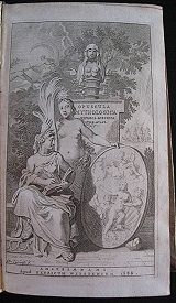 Opuscula Mythalogica. Opuscula mythologica physica et ethica.Græce et latine. Seriem eorum sistit pagina præfationem proxime sequens. Amstelædami, apud H. Wetstenium. 1688.
Octavo.Additional engraved title, title printed in red and black. 16 p. 7-752, [8] p. [*8, **4, A-Aaa8, Bbb4].
Velum; Utrecht prize binding [without prize]
Contents include; Palaephati De incredibliibus historiis; Heracliti de Incredibilibus; Homeri Poetae Vita; Ocellus Lucanus Philosophus de Universi Natura; Sext Pythagorei Senteniae e Graeco in Latinum a Ruffiono versae; Ex quorundam Pythagoreorum libris Fragmenta, in quibus de Philosophia Morali agitur
First published at Cambridge in1671the anthology contains a significant collection of lesser-known and fragmentary classical verse including pieces from Heraclides, Palaephatus,Pythagoras and Theocritus. This second edition is revised and extended. Generally clean internally, occasional old ink annotations, Ink title; binding rubbed, ties missing.
195 by 119mm (7¾ by 4¾ inches). €650
Iraklion/ Candia, Crete.
 After Claude Aubriet
"Candie, du chemin de Retimo" Amsterdam Janssoons van Waesberge. 1737
After Claude Aubriet
"Candie, du chemin de Retimo" Amsterdam Janssoons van Waesberge. 1737Copper engraved view of Iraklion/Candia, Crete. Set in a page of Dutch text [page17 Vol1. ]
from Tournefort's "Beschryving van eene Reize naar de Levant" ["Relation D'Un Voyage du Levant"] 1737 [5th edition]. Single page, large 4to, text to verso. Dark impression, with very large margins.
Blackmer/Navari 1318[1st edition] 105 by 156mm (4¼ by 6¼ inches). €120
Syros, Cyclades.
 After Claude Aubriet.
"Isle de Syra" Amsterdam Janssoons van Waesberge. 1737
After Claude Aubriet.
"Isle de Syra" Amsterdam Janssoons van Waesberge. 1737Copper engaraved map of Syros/Syra in the Cyclades from Tournefort's "Beschryving van eene Reize naar de Levant" ["Relation D'Un Voyage du Levant"] 1737 [5th edition] large 4to, verso blank. Dark impression, with very wide margins; some slight off setting from the succeeding plate,
Blackmer/Navari 1318[1st edition]. Zacharakis 3528/2302 165 by 113mm (6½ by 4½ inches). €120
Chania, Crete.
 After Claude Aubriet
"Montaignes Blanche" Amsterdam Janssoons van Waesberge. 1737
After Claude Aubriet
"Montaignes Blanche" Amsterdam Janssoons van Waesberge. 1737Copper engraved view of Chania, Crete. Set in a page of Dutch text[page8, Vol1. ]
from Tournefort's "Beschryving van eene Reize naar de Levant" ["Relation D'Un Voyage du Levant"] 1737 [5th edition]. Single page, large 4to, text to verso. Dark impression, with very large margins.
Blackmer/Navari 1318[1st edition] 100 by 152mm (4 by 6 inches). €150
Mykonos, Cyclades.
 After Claude Aubriet.
"Port de Micone" Amsterdam Janssoons van Waesberge. 1737
After Claude Aubriet.
"Port de Micone" Amsterdam Janssoons van Waesberge. 1737Copper engaraved birds eye view of the Port of Mykonos, Cyclades from Tournefort's "Beschryving van eene Reize naar de Levant" ["Relation D'Un Voyage du Levant"] 1737 [5th edition] large 4to, set in a page of Dutch text, [page111, vol1] text to verso. Good impression, with wide margins.
Blackmer/Navari 1318[1st edition]. Zacharakis 3526 102 by 166mm (4 by 6½ inches). €140
Rethymnon, Crete.
 After Claude Aubriet
"Retimo" Amsterdam Janssoons van Waesberge. 1737
After Claude Aubriet
"Retimo" Amsterdam Janssoons van Waesberge. 1737Copper engraved view of Rethymnon, Crete. Set in a page of Dutch text [page15, Vol1. ]
from Tournefort's "Beschryving van eene Reize naar de Levant" ["Relation D'Un Voyage du Levant"] 1737 [5th edition]. Single page, large 4to, text to verso. Dark impression, very large margins.
Blackmer/Navari 1318[1st edition] 110 by 162mm (4¼ by 6½ inches). €150
Gortys/ Gortyna, Crete.
 After Claude Aubriet
"Ruines de Gortyne" Amsterdam Janssoons van Waesberge. 1737
After Claude Aubriet
"Ruines de Gortyne" Amsterdam Janssoons van Waesberge. 1737Copper engraved view of the ruins of Gortys. Crete. Set in a page of Dutch text [page25, Vol 1. ]
from Tournefort's "Beschryving van eene Reize naar de Levant" ["Relation D'Un Voyage du Levant"] 1737 [5th edition]. Single page, large 4to, text to verso. Gortys was capital of Crete during the Roman period, and also the first city in Crete to adopt Christianity; it was destroyed by the Arabs in 828AD. Dark impression. with wide margins.
Blackmer/Navari 1318[1st edition] 105 by 163mm (4¼ by 6½ inches). €40
Samos, Northern Aegean.
 After Claude Aubriet.
"Samos" Amsterdam Janssoons van Waesberge. 1737
After Claude Aubriet.
"Samos" Amsterdam Janssoons van Waesberge. 1737Copper engaraved map of Samos in the Northern Aegean. set in a page of Dutch text, [page160, vol1] from Tournefort's "Beschryving van eene Reize naar de Levant" ["Relation D'Un Voyage du Levant"] 1737 [5th edition] large 4to, text to verso. Dark impression, wide margins.
Blackmer/Navari 1318[1st edition]. Zacharakis3535/2307 11o by 168mm (0½ by 6½ inches). €160
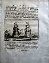
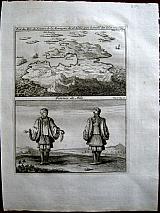
Amorgos, Cyclades.
 After Claude Aubriet.
Costume of Amorgos. "Femmes d'Amorgos" Amsterdam Janssoons van Waesberge. 1737
After Claude Aubriet.
Costume of Amorgos. "Femmes d'Amorgos" Amsterdam Janssoons van Waesberge. 1737Copper engaraved illustration of female costume of Amorgos from Tournefort's "Beschryving van eene Reize naar de Levant" ["Relation D'Un Voyage du Levant"] 1737 [5th edition] large 4to, set on a page of Dutch text [page 96, Vol1], text to verso. Dark impression, with wide margins.
Blackmer/Navari 1318[1st edition]. 104 by 165mm (4 by 6½ inches). €80
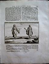
Chios, Northern Aegean.
 After Claude Aubriet.
Costume of Chios "Sciotes" Amsterdam Janssoons van Waesberge. 1737
After Claude Aubriet.
Costume of Chios "Sciotes" Amsterdam Janssoons van Waesberge. 1737Copper engaraved illustration of female costume of Chios. set in a page of Dutch text, [page150, vol1] from Tournefort's "Beschryving van eene Reize naar de Levant" ["Relation D'Un Voyage du Levant"] 1737 [5th edition] large 4to, text to verso. Dark impression, wide margins.
Blackmer/Navari 1318[1st edition]. 104 by 162mm (4 by 6½ inches). €100
Ios, Cyclades.
 After Claude Aubriet.
Costume of Ios, Cyclades. "Femmes de Nio" Amsterdam Janssoons van Waesberge. 1737
After Claude Aubriet.
Costume of Ios, Cyclades. "Femmes de Nio" Amsterdam Janssoons van Waesberge. 1737Copper engaraved illustration of female costume of Ios from Tournefort's "Beschryving van eene Reize naar de Levant" ["Relation D'Un Voyage du Levant"] 1737 [5th edition] large 4to, set on a page of Dutch text [page 101, Vol1], text to verso. Dark impression. with wide margins.
Blackmer/Navari 1318[1st edition]. 105 by 165mm (4¼ by 6½ inches). €100
Mykonos, Cyclades.
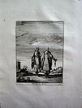 After Claude Aubriet.
Costume of Mykonos. "Femmes de Mycone" Amsterdam Janssoons van Waesberge. 1737
After Claude Aubriet.
Costume of Mykonos. "Femmes de Mycone" Amsterdam Janssoons van Waesberge. 1737Copper engaraved illustration of female costume of Mykonos, Cyclades from Tournefort's "Beschryving van eene Reize naar de Levant" ["Relation D'Un Voyage du Levant"] 1737 [5th edition] large 4to, verso blank.
In this the 1737 edition the costume appears in a slightly larger format Good impression, with wide margins.
Blackmer/Navari 1318[1st edition]. 170 by 125mm (6¾ by 5 inches). €160
Naxos, Cyclades
 After Claude Aubriet
Costume of Naxos "Naxiotes" Amsterdam Janssoons van Waesberge. 1737
After Claude Aubriet
Costume of Naxos "Naxiotes" Amsterdam Janssoons van Waesberge. 1737Copper engaraved illustration of female costume of Naxos from Tournefort's "Beschryving van eene Reize naar de Levant" ["Relation D'Un Voyage du Levant"] 1737 [5th edition] large 4to, set on a page of Dutch text [page 87, Vol1], text to verso. Dark impression, with wide margins.
Blackmer/Navari 1318[1st edition]. 105 by 166mm (4¼ by 6½ inches). €100
Tinos, Cyclades.
 After Claude Aubriet.
Costume of Tinos "Tiniotes" Amsterdam Janssoons van Waesberge. 1737
After Claude Aubriet.
Costume of Tinos "Tiniotes" Amsterdam Janssoons van Waesberge. 1737Copper engaraved illustration of female costume of Tinos. set in a page of Dutch text, [page143, vol1]from Tournefort's "Beschryving van eene Reize naar de Levant" ["Relation D'Un Voyage du Levant"] 1737 [5th edition] large 4to, text to verso. Dark impression, wide margins.
Blackmer/Navari 1318[1st edition]. 102 by 162mm (4 by 6½ inches). €100
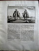
Mytilene& Andros, Northern Aegean.
 After Claude Aubriet.
Costumes of Mytilene and Andros "Femmes de Metelin/ Femmes d'Andros" & " Femmes de Petra dans l'Isle de Metelin" Amsterdam Janssoons van Waesberge. 1737
After Claude Aubriet.
Costumes of Mytilene and Andros "Femmes de Metelin/ Femmes d'Andros" & " Femmes de Petra dans l'Isle de Metelin" Amsterdam Janssoons van Waesberge. 1737Copper engraved illustration of the costumes of a lady of Mytilene beside that of Andros, above another of the costume of Petra in Mytilene. [ 2 on 1 plate] from Tournefort's "Beschryving van eene Reize naar de Levant" ["Relation D'Un Voyage du Levant"] 1737 [5th edition] large 4to, verso blank. In the 1737 edition the 2 illustrations of the costumes appear on one plate, in previous editions they were printed individually. Good impression, with wide margins.
Blackmer/Navari 1318[1st edition]. 210 by 162mm (8¼ by 6½ inches). €160
Antiparos, Cyclades.
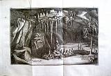 After Claude Aubriet
Interior and exterior of the Grotto of Antiparos "Grotte d"Antiparos' + "Caverne de la Grotte d' Antiparos" Amsterdam Janssoons van Waesberge. 1737
After Claude Aubriet
Interior and exterior of the Grotto of Antiparos "Grotte d"Antiparos' + "Caverne de la Grotte d' Antiparos" Amsterdam Janssoons van Waesberge. 1737Large folding copper engraved illustration of the Groto of Antiparos, with a view of the exterior.
from Tournefort's "Beschryving van eene Reize naar de Levant" ["Relation D'Un Voyage du Levant"] 1737 [5th edition] folded double page large 4to, verso blank; the second set on a page of Dutch text [page 76, Vol1], text to verso. 2 engravings. Dark impression, with wide margins.
Blackmer/Navari 1318[1st edition]. 221 by 340mm (8¾ by 13½ inches) Grotto. 105x164mm, caverne. €80
Kythnos/ Thermia, Cyclades.
 After Claude Aubriet.
Kyhthnos. "Isle de Thermia" Amsterdam Janssoons van Waesberge. 1737
After Claude Aubriet.
Kyhthnos. "Isle de Thermia" Amsterdam Janssoons van Waesberge. 1737Copper engaraved map of Kythnos/Thermia in the Cyclades from Tournefort's "Beschryving van eene Reize naar de Levant" ["Relation D'Un Voyage du Levant"] 1737 [5th edition] large 4to, verso blank.
Kithnos, also known as Thermia after the hot spings located there. Also called Fermenia. Dark impression, with very wide margins left and lower, upper and right wide.
Blackmer/Navari 1318[1st edition]. Zacharakis 3529/2303 170 by 115mm (6¾ by 4½ inches). €100
Milos/Milo, Cyclades
 After Claude Aubriet
Milo, Map & Costume "Portdu Milo, du Sommet de la Montaigne de St. Helene, avec le profill des Isles Voiines" & "Femmes de Milo" Amsterdam Janssoons van Waesberge. 1737
After Claude Aubriet
Milo, Map & Costume "Portdu Milo, du Sommet de la Montaigne de St. Helene, avec le profill des Isles Voiines" & "Femmes de Milo" Amsterdam Janssoons van Waesberge. 1737Copper engraved Map/Birdseye of the Island of Milo, with costume of the women of Milo, 2 on1 plate;
from Tournefort's "Beschryving van eene Reize naar de Levant" ["Relation D'Un Voyage du Levant"] 1737 [5th edition]. Single page, large 4to, verso blank. Dark impression, with wide margins.
Blackmer/Navari 1318[1st edition]; Zacharakis 3523/2298 210 by 162mm (8¼ by 6½ inches). €100
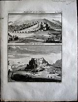
Kea/ Zia, Cyclades.
 After Claude Aubriet.
Port of Kea "Port de Zia" + "Figure de la Deesse Nemesis dans l'Isle de Zia" Amsterdam Janssoons van Waesberge. 1737
After Claude Aubriet.
Port of Kea "Port de Zia" + "Figure de la Deesse Nemesis dans l'Isle de Zia" Amsterdam Janssoons van Waesberge. 1737Copper engaraved view of the Port of Kea, set in a page of Dutch text [page133, vol1]. text to verso. with a plate showing a statue found in Kea, verso blank. 2 plates.
from Tournefort's "Beschryving van eene Reize naar de Levant" ["Relation D'Un Voyage du Levant"] 1737 [5th edition] large 4to, View of Kea :weak impression, good margins; statue: strong dark impression, wide margins.
Blackmer/Navari 1318[1st edition]. Zacharakis 3531 107 by 162mm (4¼ by 6½ inches) view. 165x110mm statue. €60
Samos, Northern Aegean.
 After Claude Aubriet.
Samos costume, antiquities and natural history. "Femmes de Samos"; "Francolin"; "Colonne du Temple de Junon a Samos"; "Bas relief antique qui se voit au coin de L'Eglise de Metelinos dans l'Isle de Samos". Amsterdam Janssoons van Waesberge. 1737
After Claude Aubriet.
Samos costume, antiquities and natural history. "Femmes de Samos"; "Francolin"; "Colonne du Temple de Junon a Samos"; "Bas relief antique qui se voit au coin de L'Eglise de Metelinos dans l'Isle de Samos". Amsterdam Janssoons van Waesberge. 1737Copper engaraved illustration of costume of females of Samos in the Northern Aegean, above an illustrationof a Francolin [ 2 on 1 plate]; with 2 more illustrations of antiquities in Samos. [3 plates]from Tournefort's "Beschryving van eene Reize naar de Levant" ["Relation D'Un Voyage du Levant"] 1737 [5th edition] large 4to, verso blank. The "bas relief" set in a page of Dutch text[page170, vol1] with text to verso. All dark impressions, with wide margins.
Blackmer/Navari 1318[1st edition]. 212 by 164mm (8¼ by 6½ inches) Costume and Francolin:162x110mm, Column; 90 x106mm Bas relief. €120
Skyros, Sporades.
 After Claude Aubriet.
Skyros. Amsterdam Janssoons van Waesberge. 1737
After Claude Aubriet.
Skyros. Amsterdam Janssoons van Waesberge. 1737Copper engaraved Birds eye view/ map of the port of Skyros in the Sporades; set in a page of Dutch text [page 175, vol1] from Tournefort's "Beschryving van eene Reize naar de Levant" ["Relation D'Un Voyage du Levant"] 1737 [5th edition] large 4to, text to verso. . Good impression, with wide margins.
Blackmer/Navari 1318[1st edition]. Zacharakis 3538. 108 by 167mm (4¼ by 6½ inches). €30
Syros, Cyclades.
 After Claude Aubriet.
SyrosTown "Bourg de Syra" Amsterdam Janssoons van Waesberge. 1737
After Claude Aubriet.
SyrosTown "Bourg de Syra" Amsterdam Janssoons van Waesberge. 1737Copper engaraved view of the town of Syros/Syra in the Cyclades from Tournefort's "Beschryving van eene Reize naar de Levant" ["Relation D'Un Voyage du Levant"] 1737 [5th edition] large 4to, set in a page of Dutch Text [page 127, vol1] text to verso. Dark impression, with very wide margins; some slight off setting from the succeeding plate,
Blackmer/Navari 1318[1st edition]. 105 by 164mm (4¼ by 6½ inches). €120
Assamcale, Armenia
 After Claude Aubriet.
"Assamcalé. " "Assamcalé, du côté d'Erzeron" & "Assamcalé du côté de cars" Amsterdam. Janssoons van Waesberge. 1737
After Claude Aubriet.
"Assamcalé. " "Assamcalé, du côté d'Erzeron" & "Assamcalé du côté de cars" Amsterdam. Janssoons van Waesberge. 17372 Copper engraved views of Assancale in Armenia the town and fort approached from Kars and Erzurum. [ 2 0n 1 Plate] from the 2nd volume of Tournefort's "Beschryving van eene Reize naar de Levant" ["Relation D'Un Voyage du Levant"] 1737 [5th edition] large 4to verso blank. In the 1737 edition the 2 views are on 1 plate, in earlier editions they appear seperately. Dark impression, with wide margins.
Blackmer/Navari 1318[1st edition]. 214 by 164mm (8½ by 6½ inches). €50
Company: Bryan, Mary Louise.
Address: Ag. Andrianoy 92 , 21 100 Nafplio, Greece.
Vat No: EL 119092581