MAPS & VIEWS
PRINTS
BOOKS
Greenland, North Atlantic.
 Greenland. Groenland. Paris. Thierry. Denys. 1683
Copper engraved map of Greenland with part of the coast of Canada from Mallet's "Description de l'Univers" 1st edition. Text to verso. Dark impression.
150 by 105mm (6 by 4¼ inches). €150
Hurons.
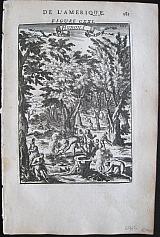 Hurons. Hurons. Paris Thierry. Denys. 1683
Copper engraved illustration of a Huron camp from Mallet's "Description de l'Univers" 1st edition. Text to verso. Dark impression; light toning; light spotting left blank margin.
146 by 103mm (5¾ by 4 inches). €40
Mexico
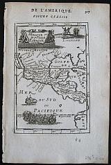 Mexico Mexique ou Nouvelle Espagne. Paris. Thierry. Denys. 1683
Copper engraved map of Mexico and central America from Mallet's "Description de l'Univers" 1st edition. Text to verso.
The map shows Mexico and Central America; with the island of California to the West. New Mexico, Florida, Louisiana, and extending down through Guatamala, Honduras, Nicaragua and Costa Rica, with part of Peru to the South-east.
Strap work cartouche; large fleet of ships to sea and natives dancing within Louisiana. Dark impression; very light toning.
150 by 100mm (6 by 4 inches). €120
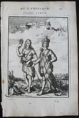
Patagonian Costumes.
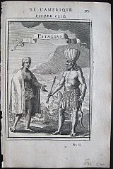 Patagonians. Patagons. Paris Thierry. Denys. 1683
Copper engraved illustration of Patagonian costumes from Mallet's "Description de l'Univers" 1st edition. Text to verso. Dark impression; light toning; minor spotting lower blank margin.
155 by 111mm (6 by 4¼ inches). €30
Peruvian Costumes.
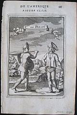 Peruvian People. Ples. du Perou. Paris Thierry. Denys. 1683
Copper engraved illustrations Peruvian costumes from Mallet's "Description de l'Univers" 1st edition. Text to verso. Dark impression; light toning.
156 by 112mm (6¼ by 4½ inches). €30
São Salvador first capital of Brazil, .
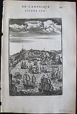 São Salvador. S. Salvador. Paris. Thierry. Denys. 1683
Copper engraved view of São Salvador Brazil from Mallet's "Description de l'Univers" 1st edition. Text to verso.
Founded by the Portuguese in 1549 as the first capital of Brazil, Salvador is one of the oldest colonial cities in the Americas. Dark impression; light toning; 1 small spot to image.
148 by 103mm (5¾ by 4 inches). €50
Native Americans.
 View of Pomeiocc, Virginians & Hurons "Ples, de Virginie". "Hurons" Paris. Thierry. Denys. 1683
3 Copper engraved illustrations of Native Americans: a view of Pomeiocc, Virginia, with an inset of the interior of a Powhatan Lodge [ based on that of John Smith's map of Virginia ]; Virginians; Hurons, from Mallet's "Description de l'Univers" 1st edition. Text to versos. 3 plates Dark impression; worm hole [2mm] and small worm track[10mm] to inner blank margin.
160 by 117mm (6¼ by 4½ inches)Pomeiocc; 156x114mm, Virginians; 146x104mm Hurons. €90
Virginians.
 Virginians. Ples de Virginie. Paris Thierry. Denys. 1683
Copper engraved illustration of Native Virginians from Mallet's "Description de l'Univers" 1st edition. Text to verso. Dark impression; light toning; minor spotting left blank margin.
155 by 114mm (6 by 4½ inches). €40
South America.
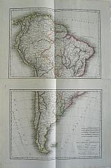 Tardieu, P.A.F.
Map of South America drawn after the observations and maps of Messers de la Condamine, La Cruz, Ulloa, Antoine Cornel et Jean Langara. " Carte de l'Amérique Méridionalé, Dressée d'aprèsles Observations et les Cartes de MM. de la Condamine, La Cruz, Ulloa, Antoine Cornel et Jean Langara." Paris E. Mentelle & P.G. Chanlaire. 1806
Tardieu, P.A.F.
Map of South America drawn after the observations and maps of Messers de la Condamine, La Cruz, Ulloa, Antoine Cornel et Jean Langara. " Carte de l'Amérique Méridionalé, Dressée d'aprèsles Observations et les Cartes de MM. de la Condamine, La Cruz, Ulloa, Antoine Cornel et Jean Langara." Paris E. Mentelle & P.G. Chanlaire. 1806Copper engraved map on two sheets from Mentelle Chanlaire's " Atlas Universale de géographie physique et politique, ancienne et moderne" engraved by Tardieu. Original outline colour; verso blank. Dark impression; clean and bright.
370 by 480mm (14½ by 19 inches).each sheet to plate mark. €200
Mexico /New Spain. Americas.
 Nova Hispania "Hispaniae Novae sive Magnae, Recens et Vera decritio 1579." "Antverpiæ"/Antwerp. "ex Officiana Plantiana" . Plantijn Christoffel. 1595
Copper engraved map of Nova Hispania ; South West Mexico from Ortelius' "Theatrum Orbis Terrarum" 1595 edition; black & white. Latin text to verso.
2 decorative cartouches ; gallions to sea. Good dark impression; wormhole [3mm] to lower centre fold; another to upper blank margin; minor lifting of paper /fault, upper plate close to "Septemtrio" minor loss to plate.
Van de Krogt :3; .Koeman: Ort29/ 7; van den Broecke:13. 345 by 502mm (13½ by 19¾ inches). €400
Henry Popple's Map of the "British Empire in America" in 4 Sheets.
 A Map of the British Empire In America with the French, Spanish and the Dutch Settlements adjacent thereto by Henry Popple.
A) Nouvelle Carte Particulére de la Amerique ou sont exactement marquéese une Partie de la Baye d'Hudson, le Pays Kilistinons, la Source de la Grande Rivière de Mississipi, le Pays des Illinois &c.;
B)Nouvelle Carte Particulére de la Amerique ou sont exactement marquées la Nouvelle Bretagne, le Canada ou Nouvelle France, la Nouvelle Ecosse, la Nouvelle Angleterre, la nouvelle York, la Pensilvanie, Mary-land, la Caroline septrionale, l'Ile de terre Neuve. le Grand Banc &c.;
C)Nouvelle Carte Particulére de la Amerique ou sont exactement marquées les Provinces suivants comme la Caroline meridionale, la Floride, la Louisiane, le Mexique,le Jucatan, le Guatimala, le Darien,& une Partie de Cuba.;
D)Nouvelle Carte Particulére de la Amerique ou sont exactement marquées lesIles de Bermude, la Jamaique, Saint Domingue, les Antilles, la Terre Ferme &c. Amsterdam. Covens et Mortier c1741
Copper engraved maps[ 4 sheets] from Covens & Mortier's " Nieuwe Atlas, Inhoudennde vier Gedeeltens der Waereld.. " Original full wash colour; verso blank.
Covens and Mortier edition of Popple's map of the British Empire in America on 4 sheets. with titles in French above each map:
A) Nouvelle Carte Particulére de la Amerique ou sont exactement marquéese une Partie de la Baye d'Hudson, le Pays Kilistinons, la Source de la Grande Rivière de Mississipi, le Pays des Illinois &c.;
B)Nouvelle Carte Particulére de la Amerique ou sont exactement marquées la Nouvelle Bretagne, le Canada ou Nouvelle France, la Nouvelle Ecosse, la Nouvelle Angleterre, la nouvelle York, la Pensilvanie, Mary-land, la Caroline septrionale, l'Ile de terre Neuve. le Grand Banc &c.;
C)Nouvelle Carte Particulére de la Amerique ou sont exactement marquées les Provinces suivants comme la Caroline meridionale, la Floride, la Louisiane, le Mexique,le Jucatan, le Guatimala, le Darien,& une Partie de Cuba.;
D)Nouvelle Carte Particulére de la Amerique ou sont exactement marquées lesIles de Bermude, la Jamaique, Saint Domingue, les Antilles, la Terre Ferme &c.
Large black & white decorative title cartouche [as issued] to lower corner of sheet C
Black and white strap work cartouche [as issued] to upper corner of sheet A, containing "the Approbation of the Right Honourable the Lords Commissioners of Trade and Plantations.." and the approbation of Edmund Halley: "I have seen the abovementioned Map, which as far as I am Judge, seems to have been laid down with great Accuracy, and to shew the Position of the different Provinces & Islands in that Part of the Globe more truly than any yet extant."
Henry Popple produced this map under the auspices of the Lord Commissioners of Trade and Plantations to help settle disputes arising from the rival expansions of English, Spanish and French colonies. "France claimed not only Canada, but also territories drained by the Mississippi and its tributaries - in practical terms, an area of half a continent" (Goss The Mapping of North America p.122.)
Popple's map had quasi-official status, and a copy was sent to each of the governments of each of the colonies.
Popple's famous map on 20 sheets appeared in1733. Popple drew on many sources: the maps of Guillaume De L'Isle and Nicholas de Fer; John Barnwell's manuscript map of the south-eastern colonies of circa 1721 which included up-to-date information on the Indian settlements in the interior; and Cadwallader Colden's famous Map of the Country of the Five Nations. In all, it covers from the Grand Banks off Newfoundland to about ten degrees west of Lake Superior, and from the Great Lakes to the north coast of South America.
On the original 20 sheet map several of the sections are illustrated with pictorial insets, including views of New York City, Niagara Falls, Mexico City, and Quebec, and inset maps of Boston, Charles-Town, Providence and Bermuda. Covens and Mortier published these as seperate map sheets, [ see item 3062].
Benjamin Franklin ordered two of the original map for the Pennsylvania Assembly on 22 May 1746, "one bound and the other in sheets." One of these was hanging in the Pennsylvania State House when the Declaration of Independence was signed on July 4th, 1776. John Adams noted that Popple's map was "the largest I ever saw, and the most distinct." Copies were found in the private collections of several of the wealthier founding fathers, including George Washington. Dark impressions; bright full wash colour; printed on heavy paper; old red crayon numbers to verso.
Sheet a : tight margin to right side [approx 3mm]. Light horizontal crease to upper half visible on verso only
Sheet B: trimmed to plate mark on right side. Slight horizontal crease to upper half.
Sheet C: tight margin to right side [approx 2-4mm].
Sheet D: tight margin to right side [approx 4-6mm].
Koeman I: C&M 8:maps 107, 108, 109, 110; 610 by 535mm (24 by 21 inches) each sheet. Total size if joined approx. 1200x1070mm ( 46x 41 inches) €15000
Forts and Islands for Henry Popple's Map of the "British Empire in America"
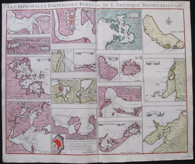 Les Principales Fortresses Ports &c de L'Amerique Septrionale.
The Harbour of Placentia; The Harbour of Anapolis Royal; Boston Harbour; New York and Perthamboy Harbours;
The Town and Harbour of Charles town in South Carolina; Harbour of St. Augustin;The Harbour of Providence; The Havana; Bay of St Iagoin Cuba; A Plan of the Harbour of Port Antonio in Jamaica.
Fort Royal in Martinica; The Island of Barbadoes; Antigua; Kingston Harbour Jamaica; Bermuda or Summer Islands;
Curacao; Carthage on the Coast of New Spain; Harbour of Porto Bello. Amsterdam. Covens et Mortier c1741
Copper engraved map sheet with 17 (18) small plans and maps of forts, harbours and Islands for Popple's Map of the British Empire in America from Covens & Mortier's Nieuwe Atlas, Inhoudennde vier Gedeeltens der Waereld..
Original full wash colour; verso blank.
Covens and Mortier published the plans and maps which could be inserted on the Popple map as a separate map sheet .
Each plan or map has its title on a banner except the island of Curacoa and the plan of Port Antonio [with inset of the fort and key]
All are 150mm wide but of varying heights. St Augustine & Providence ; Havana & St Iago; Barbadoes & Antiqua in pairs.
Each has a mile scale and the map of Curacoa includes a compass rose.
A scarce and desirable sheet Dark impressions; bright full wash colour; printed on heavy paper;upper margin trimmed to plate mark above title; old red crayon numbers to verso.
Koeman I: C&M 8:maps 111; 520 by 620mm (20½ by 24½ inches). €2200
Henry Popple's Key Map of the "British Empire in America".
 Carte Particulére de Amerique Septrionale. A Map of the British Empire In America with the French, Spanish and the Dutch Settlements adjacent thereto by Henry Popple.
Amsterdam. Covens et Mortier c1741
Copper engraved map from Covens & Mortier's " Nieuwe Atlas, Inhoudennde vier Gedeeltens der Waereld.. " Original full wash colour; verso blank.
Covens and Mortier edition of the key sheet to Popple's 20 sheet map with inset views of New York, Quebec, Mexico City and the Niagara Falls [black& white as issued] 18 coloured inset plans of ports and islands.[ see item 3062]
Black & white title cartouche as issued.
To lower right corner is the "the Approbation of the Right Honourable the Lords Commissioners of Trade and Plantations," Popple's map had quasi-official status, and a copy was sent to each of the governments of each of the colonies and the approbation of Edmund Halley: "I have seen the abovementioned Map, which as far as I am Judge, seems to have been laid down with great Accuracy, and to shew the Position of the different Provinces & Islands in that Part of the Globe more truly than any yet extant."
Popple's famous map on 20 sheets appeared 1733 Popple drew on many sources: the maps of Guillaume De L'Isle and Nicholas de Fer; John Barnwell's manuscript map of the south-eastern colonies of circa 1721 which included up-to-date information on the Indian settlements in the interior; and Cadwallader Colden's famous Map of the Country of the Five Nations. In all, it covers from the Grand Banks off Newfoundland to about ten degrees west of Lake Superior, and from the Great Lakes to the north coast of South America. Several of the sections are illustrated with pictorial insets, including views of New York City, Niagara Falls, Mexico City, and Quebec, and inset maps of Boston, Charles-Town, Providence and Bermuda.
Benjamin Franklin ordered two of the original map for the Pennsylvania Assembly on 22 May 1746, "one bound and the other in sheets." One of these was hanging in the Pennsylvania State House when the Declaration of Independence was signed on July 4th, 1776. John Adams noted that Popple's map was "the largest I ever saw, and the most distinct." Copies were found in the private collections of several of the wealthier founding fathers, including George Washington. Dark impression; bright full wash colour; printed on heavy paper; light soiling; old red crayon numbers to verso.
Koeman I: C&M 8:106; 525 by 495mm (20¾ by 19½ inches). €5000
Hispaniola.
 Girolamo Porro Of Padua
Descrittione de L'Isole Spagnuola Spagnuola Venice Gorgio Angeliera a instantia de gli Herede di Simone Galignani de Karera 1590
Girolamo Porro Of Padua
Descrittione de L'Isole Spagnuola Spagnuola Venice Gorgio Angeliera a instantia de gli Herede di Simone Galignani de Karera 1590Copper engraved map of the island of Hispagniola by Girolamo Porro from Porcacchi's " L'Isole piu Famose del Mondo" Set in a page of descriptive Italian text [page 165], with decorative, woodcut headpiece and historiated initial. Single page. folio, text to verso.
The map shows the island of Hispaniola present day Haiti and the Dominican Republic; numerous sea monsters Mermen and ships to sea. Dark Impression; worm track to upper left blank margin.
Adams P-1906; Alden and Landis 590/54; BMC Italian, p.534; Sabin 64151. 110 by 150mm (4¼ by 6 inches). €170
Brazil.
 A.d'Winter
Brazil Brasil, waar van de Kust door de Portugeezen bezeten, .... Amsterdam Francois Halma 1705
A.d'Winter
Brazil Brasil, waar van de Kust door de Portugeezen bezeten, .... Amsterdam Francois Halma 1705Copper engraved map of Brazil by N. Sanson from Halma's Algemeene Werelde BeschryvingVol. 3 Black and white; title in Dutch; verso blank;
Attractive small map of Brazil; title cartouche surrounded by garland of leaves in centre of country.
This map appeared in Algemeene Weereld-Beschryving, nae de Rechte Verdeeling der Landschappen, Plaetsen, Zeeën, Rivieren, &c. Geographisch, Politisch, Historisch, Chronologisch en Genealogisch,a Dutch edition of A. Phérotée de la Croix's Nouvelle Methode Pour Apprendre Facilement la Geographie Universelle, which first appeared in 1690. Dark impression; minor dampstain at top of centre fold.
Keoman: Hal 1; Phillips 528. 202 by 280mm (8 by 11 inches). €350
Sanson's influential map of Canada and the Great Lakes.
 A.d'Winter
Canada of New France. Canada of Niew Vrankryk. Getrokken uit verschiede Franche, Engelsche, en en Hollandsche Beschrivingern enz. ... Amsterdam Francois Halma 1705
A.d'Winter
Canada of New France. Canada of Niew Vrankryk. Getrokken uit verschiede Franche, Engelsche, en en Hollandsche Beschrivingern enz. ... Amsterdam Francois Halma 1705Copper engraved map of Canada by N. Sanson from Halma's Algemeene Werelde BeschryvingVol. 3 Black and white; title in Dutch; verso blank; strapwork title cartouche.
Attractive small map of Canada and the Great Lakes, a reduced version of one of the most influential seventeenth century maps of the French and English colonies in North America. It concentrates on the region of greatest French interest. The entire Great Lakes basin and the St. Lawrence River are shown in great detail. The most important aspect of the map is the first appearance of L. Erie, ou du Chat as a recognizable lake on an atlas map. This delineation influenced the cartography of the region for more than 100 years and was not superceded until Delisle's "Carte du Canada" in 1703. The map is also an outstanding source for Indian tribal names and locations. Two names:Aouentsiouaeronand Attiouandaronsappear here for the first time. Lake Superior and Michigan Lac du Puansare left open-end to the west. Embellished with a nice title cartouche and engraved by Anthoine d'Winter.
This is the third state. Published in Francois Halma's Dutch edition of A. Pherotee de la Croix's Nouvelle Methode Pour Apprendre facilement la Geographie Universelle.
Dark impression; dampstaining to lower margin just entering plate; centrefold and 2 further folds, to fit in binding.
Keoman: Hal 1; Phillips 528; Burden #575; Kershaw #138; McCorkle #683.5. 212 by 308mm (8¼ by 12¼ inches). €500
Chili.
 A.d'Winter
Chili. Chili, Getrokken uit Alfonso de Oualle, Jesuit, en in Dertien Rechts-Gebieden Verdeelt.. Amsterdam Francois Halma 1705
A.d'Winter
Chili. Chili, Getrokken uit Alfonso de Oualle, Jesuit, en in Dertien Rechts-Gebieden Verdeelt.. Amsterdam Francois Halma 1705Copper engraved map of Chili by N. Sanson from Halma's Algemeene Werelde BeschryvingVol. 3 Black and white; title in Dutch; verso blank; strapwork title cartouche.
Small version of Sanson's important map of Chili showing the Cuyo provinces. The map is based on the descriptions of Alfonso de Ovalle.
This map appeared in Algemeene Weereld-Beschryving, nae de Rechte Verdeeling der Landschappen, Plaetsen, Zeeën, Rivieren, &c. Geographisch, Politisch, Historisch, Chronologisch en Genealogisch, a Dutch edition of A. Phérotée de la Croix's Nouvelle Methode Pour Apprendre Facilement la Geographie Universelle, which first appeared in 1690. Dark impression.
Keoman: Hal 1; Phillips 528. 270 by 195mm (10¾ by 7¾ inches). €200
Florida.
 A.d'Winter
Florida. Florida zoo als het van de Spaanschen en Franschen wordt bezeten. ... Amsterdam Francois Halma 1705
A.d'Winter
Florida. Florida zoo als het van de Spaanschen en Franschen wordt bezeten. ... Amsterdam Francois Halma 1705Copper engraved map of Florida by N. Sanson from Halma's Algemeene Werelde BeschryvingVol. 3 Black and white; title in Dutch; verso blank; strapwork title cartouche.
This influential map shows the Spanish and French possessions in the southern part of the United States. The map extends from the southernmost part of Virginia to the coast of what is now Texas. When first introduced by Sanson in 1657, this map was the first to use the name L. Eriein an atlas and to introduce several new rivers in Virginia. The French claims in the Carolinas are reasserted with the region named Floride Francoise, despite the region not having had any French presence for nearly 100 years. The place name Caroline is not related to the future English colony of Carolina. Instead it is a confusion between the French Fort Caroline on the St. Johns River, and Charlefort that was located near Port Royal. According to Burden, this is the third state of the map.
Published in Francois Halma's Dutch edition of A. Pherotee de la Croix's Nouvelle Methode Pour Apprendre facilement la Geographie Universelle.
Dark impression; pin hole paper fault to upper right , below latitude 40.
Keoman: Hal 1; Phillips 528; Burden #546; Cumming (SE) #53. 178 by 255mm (7 by 10 inches). €500
Guatemala .
 A.d'Winter
Guatemala. Landstreek van Guatemala .. Amsterdam Francois Halma 1705
A.d'Winter
Guatemala. Landstreek van Guatemala .. Amsterdam Francois Halma 1705Copper engraved map of Guatemala by N. Sanson from Halma's Algemeene Werelde BeschryvingVol. 3 Black and white; title in Dutch; verso blank; strapwork title cartouche.
This map appeared in Algemeene Weereld-Beschryving, nae de Rechte Verdeeling der Landschappen, Plaetsen, Zeeën, Rivieren, &c. Geographisch, Politisch, Historisch, Chronologisch en Genealogisch, a Dutch edition of A. Phérotée de la Croix's Nouvelle Methode Pour Apprendre Facilement la Geographie Universelle, which first appeared in 1690. Dark impression.
Keoman: Hal 1; Phillips 528; B 187 by 280mm (7¼ by 11 inches). €250
Guyana.
 A.d'Winter
Guyana. Guiana verdeelt Guina en Caribana.. Amsterdam Francois Halma 1705
A.d'Winter
Guyana. Guiana verdeelt Guina en Caribana.. Amsterdam Francois Halma 1705Copper engraved map of Guyana by N. Sanson from Halma's Algemeene Werelde BeschryvingVol. 3 Black and white; title in Dutch; verso blank; strapwork title cartouche.
The map shows a large lake or inland sea Lac, ou Mer que les Caribes appellent Parime les Iaoyi Roponowini.and located on its shores the mythical city of El Doradoor Manoa.
Lake Parime or Lake Parimais a legendary lake located in South America. It was reputedly the location of the fabled city of El Dorado,also known as Manoa, much sought-after by European explorers. Repeated attempts to find the lake failed to confirm its existence, and it was dismissed as a myth along with the city. The search for Lake Parimeled explorers to map the rivers and other features of southern Venezuela, northern Brazil, and southwestern Guyana before the lake's existence was definitively disproved in the early 19th century. Some explorers proposed that the seasonal flooding of the Rupununi savannahmay have been misidentified as a lake. Recent geological investigations suggest that a lake may have existed in northern Brazil, but that it dried up some time in the 18th century. Both "Manoa"(Arawak language) and "Parime" (Carib language) are believed to mean "big lake".
This map appeared in Algemeene Weereld-Beschryving, nae de Rechte Verdeeling der Landschappen, Plaetsen, Zeeën, Rivieren, &c. Geographisch, Politisch, Historisch, Chronologisch en Genealogisch, a Dutch edition of A. Phérotée de la Croix's Nouvelle Methode Pour Apprendre Facilement la Geographie Universelle,which first appeared in 1690. Dark impression.
Keoman: Hal 1; Phillips 528. 202 by 280mm (8 by 11 inches). €200
Magellanica: Tierra del Fuego.
 A.d'Winter
Magellanica. De Straat van Magellanes met het Magellanisch Landt en d'Eilanden.. Amsterdam Francois Halma 1705
A.d'Winter
Magellanica. De Straat van Magellanes met het Magellanisch Landt en d'Eilanden.. Amsterdam Francois Halma 1705Copper engraved map of Peru by N. Sanson from Halma's Algemeene Werelde BeschryvingVol. 3 Black and white; title in Dutch; verso blank; strapwork title cartouche.
Small map of Tierra del Fuego showing both the Strait of Magellan and Le Maire Strait. Inland detail is confined to a mountain range and several rivers, and the mythical Destroit de Browers is labeled at far right.
This map appeared in Algemeene Weereld-Beschryving, nae de Rechte Verdeeling der Landschappen, Plaetsen, Zeeën, Rivieren, &c. Geographisch, Politisch, Historisch, Chronologisch en Genealogisch, a Dutch edition of A. Phérotée de la Croix's Nouvelle Methode Pour Apprendre Facilement la Geographie Universelle, which first appeared in 1690. Dark impression.
Keoman: Hal 1; Phillips 528. 191 by 243mm (7½ by 9½ inches). €300
Mexico and the Yucatan Peninsular.
 A.d'Winter
Mexico. T Gebiedt van Mexico... Amsterdam Francois Halma 1705
A.d'Winter
Mexico. T Gebiedt van Mexico... Amsterdam Francois Halma 1705Copper engraved map of Mexico by N. Sanson from Halma's Algemeene Werelde BeschryvingVol. 3 Black and white; title in Dutch; verso blank; strapwork title cartouche.
The map shows Mexico including the Yucatan peninsula, part of present-day Guatemala and Honduras.
This map appeared in Algemeene Weereld-Beschryving, nae de Rechte Verdeeling der Landschappen, Plaetsen, Zeeën, Rivieren, &c. Geographisch, Politisch, Historisch, Chronologisch en Genealogisch, a Dutch edition of A. Phérotée de la Croix's Nouvelle Methode Pour Apprendre Facilement la Geographie Universelle, which first appeared in 1690. Dark impression.
Keoman: Hal 1; Phillips 528; B 173 by 280mm (6¾ by 11 inches). €250
California as an Island.
 A.d'Winter
North America. Noorder America. Amsterdam Francois Halma 1705
A.d'Winter
North America. Noorder America. Amsterdam Francois Halma 1705Copper engraved map of North America by N. Sanson from Halma's Algemeene Werelde BeschryvingVol. 3 Black and white; title in Dutch; verso blank; strapwork title cartouche.
Attractive small map showing North America with California as an Island
California is shown with an indented northern coastline in the Foxe form. The detached coastline to the northwest of California is named Terre de Iesso ou Ieco,rather than reflecting Sanson's earlier belief that it was an extension of the American continent. The R. de Nortdrains into the Gulf of California from a large interior lake in the country of Les Apaches. The two western-most Great Lakes are left open-ended and Lake Erieremains unnamed. Engraved by Antoine d'Winter. This is the third state which includes a peninsula inserted northeast of California, the Carolinas attributed to the French, N. Iork added below N. Amstredam, and an umlaut over the "Roy" in the title.
This map appeared in Algemeene Weereld-Beschryving, nae de Rechte Verdeeling der Landschappen, Plaetsen, Zeeën, Rivieren, &c. Geographisch, Politisch, Historisch, Chronologisch en Genealogisch, a Dutch edition of A. Phérotée de la Croix's Nouvelle Methode Pour Apprendre Facilement la Geographie Universelle, which first appeared in 1690. Dark impression; dampstaining to edges not entering image.
Keoman: Hal 1; Phillips 528; Burden #545; McLaughlin #89-3. 204 by 284mm (8 by 11¼ inches). €700
Paraguay.
 A.d'Winter
Paraguay. Paraguay Verdeelt in zyn Voornaamste Deelen Volgens de Laatste Reisbeschryvinge .... Amsterdam Francois Halma 1705
A.d'Winter
Paraguay. Paraguay Verdeelt in zyn Voornaamste Deelen Volgens de Laatste Reisbeschryvinge .... Amsterdam Francois Halma 1705Copper engraved map of Paraguayby N. Sanson from Halma's Algemeene Werelde BeschryvingVol. 3 Black and white; title in Dutch; verso blank; strapwork title cartouche.
The map shows the region of present day Paraguay, Uruguay, northern Argentina and southern Brazil. The Rio de la Plata is the main feature of the map along with the mountains and volcanoes of the Cordillera de los Andes. Engraved by Antoine de Winter.
This map appeared in Algemeene Weereld-Beschryving, nae de Rechte Verdeeling der Landschappen, Plaetsen, Zeeën, Rivieren, &c. Geographisch, Politisch, Historisch, Chronologisch en Genealogisch, a Dutch edition of A. Phérotée de la Croix's Nouvelle Methode Pour Apprendre Facilement la Geographie Universelle, which first appeared in 1690. Dark impression; minor dampstain at top of centre fold.
Keoman: Hal 1; Phillips 528. 210 by 280mm (8¼ by 11 inches). €200
Peru.
 A.d'Winter
Peru. Peru, en de Loop van den Amazoonstroom.. Amsterdam Francois Halma 1705
A.d'Winter
Peru. Peru, en de Loop van den Amazoonstroom.. Amsterdam Francois Halma 1705Copper engraved map of Peru by N. Sanson from Halma's Algemeene Werelde BeschryvingVol. 3 Black and white; title in Dutch; verso blank; strapwork title cartouche.
The map shows the western part of the continent and the full course of the Amazon. The spurious Lac, ou Mer de Parime is prominent as is the location of the mythical city Manoa el Dorado.
This map appeared in Algemeene Weereld-Beschryving, nae de Rechte Verdeeling der Landschappen, Plaetsen, Zeeën, Rivieren, &c. Geographisch, Politisch, Historisch, Chronologisch en Genealogisch, a Dutch edition of A. Phérotée de la Croix's Nouvelle Methode Pour Apprendre Facilement la Geographie Universelle, which first appeared in 1690. Dark impression. Upper margin short, cut to plate mark.
Keoman: Hal 1; Phillips 528. 207 by 195mm (8¼ by 7¾ inches). €200
Caribbean Islands.
 A.d'Winter
The Antilles, Bahamas and Caribbean Islands. De Antillische Eilanden waar onder zyn de Lucaysche en Caribesche.. Amsterdam Francois Halma 1705
A.d'Winter
The Antilles, Bahamas and Caribbean Islands. De Antillische Eilanden waar onder zyn de Lucaysche en Caribesche.. Amsterdam Francois Halma 1705Copper engraved map of Caribbean by N. Sanson from Halma's Algemeene Werelde BeschryvingVol. 3 Black and white; title in Dutch; verso blank; strapwork title cartouche.
The map shows the islands of the Caribbean with the tip of Florida to the North and the coast line of Honduras and Venezuela to the South
This map appeared in Algemeene Weereld-Beschryving, nae de Rechte Verdeeling der Landschappen, Plaetsen, Zeeën, Rivieren, &c. Geographisch, Politisch, Historisch, Chronologisch en Genealogisch, a Dutch edition of A. Phérotée de la Croix's Nouvelle Methode Pour Apprendre Facilement la Geographie Universelle, which first appeared in 1690. Dark impression. Upper margin short, cut to plate mark ; extra folds to fit in binding; light dampstaining to lower margin, just entering plate.
Keoman: Hal 1; Phillips 528. 215 by 280mm (8½ by 11 inches). €350
Colombia and Venezuela.
 A.d'Winter
The New Kingdom of Granada. T Vaste Landt van 't Niew Koningryk Granada. Amsterdam Francois Halma 1705
A.d'Winter
The New Kingdom of Granada. T Vaste Landt van 't Niew Koningryk Granada. Amsterdam Francois Halma 1705Copper engraved map of Colombia, Venezuela and Panama by N. Sanson from Halma's Algemeene Werelde BeschryvingVol. 3 Black and white; title in Dutch; verso blank; strapwork title cartouche.
The map shows the Isthmus of Panama and North Western South America including most of present day Columbia and part of Venezuela. Regional boundaries are shown along with missions, towns, major rivers and mountains. The mythical Lage de Parime with the fabled city of Manoa del Doradois shown at bottom right.
This map appeared in Algemeene Weereld-Beschryving, nae de Rechte Verdeeling der Landschappen, Plaetsen, Zeeën, Rivieren, &c. Geographisch, Politisch, Historisch, Chronologisch en Genealogisch, a Dutch edition of A. Phérotée de la Croix's Nouvelle Methode Pour Apprendre Facilement la Geographie Universelle, which first appeared in 1690. Dark impression.
Keoman: Hal 1; Phillips 528. 194 by 290mm (7¾ by 11½ inches). €200
The Caribbean, the Antilles and the Lucayan Archipelgo.
 The Antilles and the Lucayes and Caribs in between " Les Antilles &c. Entre lesquelles sont Les Lucayes, et Les Caribes" Paris Par N Sanson ... Chez Pierre Mariette. 1656-8
Copper engraved map of the Caribbean by Nichols sanson from his"Cartes Generales De Toutes Les Parties Du Monde". Original outline colour; verso blank.
The map shows all the islands of the Caribbean with the southern tip of Florida and the coasts to the south.
Decorative title cartouche . Good impression; slight dampstaining to edges, far from plate ; small stain just below cartouche.
395 by 556mm (15½ by 22 inches). €1200
The Antilles & Bahamas.
 The Greater & Lesser Antilles and the Lucaye islands with part of the North Sea. "Les Grandes et Petit Isles Antilles et les Iles Lucayes avec une partie de la Mer Nord Par Le S. Robert." Venice, Remondini, 1779
Copper engraved map of the Antilles and Lucayan Archipelago /Bahamas from Santini's "Atlas universel dressé sur les meilleures cartes modernes". Original outline colour; verso blank.
The map is a reissue of the map by Robert de Vaugondy' from his "Atlas Universel"first published in 1757; it shows the islands of the Caribbean with the tip of Florida with the Keys and the coasts of Honduras,Costa Rica and South America .
Title cartouche to upper right, decorated with ships, shells and fishing nets. Dark impression; minor spotting mainly to blank margins.
480 by 595mm (19 by 23½ inches). €600
The Americas with California as an Island.
 The New World: America North and South with the Kingdoms, Provinces and Islands. "Novus orbis sive America Medionalis et Septentrionalis per sua Regna, Provincias et insulas Juxta Observatioes et Descriptiones Recentis. Divisa et Adornata cura et Opera Matth. seutter Chalc. Aug.". Augsburg, Seutter, Matthäus c 1730
Copper engraved map of the American continent from Seutter's "Atlas Novus". Original old full wash colour; verso blank.
The map,engraved for Seutter by Gottfried Rogg, shows the whole of the Americas, North and South with California as an island. The map has full orignal wash colour designating the kingdoms and provinces; colored lines showing the routes of explorers in the Pacific with the dates of their voyages and a host of other information.
Very large decorative vignettes around title and text to upper and lower left corners. The upper shows 3 Europeans seated with the Madonna above text and native Americans at an alter, thus depicting the arrival of Christianity to the Continent. The lower vignette around the title has a native American monarch possibly Atahualpa surrounded by other natives and exotic fauna, in the background figures, possibly slaves, harvest sugar cane and tobacco. Good dark impression;some soiling mainly to margins; 2 stains in Pacific possibly from wax; slight browning to centrefold; margins short due to size of plate [approx. 10mm to image]; old ink title to verso.
McLaughlin 211; Tooley, 91 p.132. 502 by 582mm (19¾ by 23 inches). €2000
Company: Bryan, Mary Louise.
Address: Ag. Andrianoy 92 , 21 100 Nafplio, Greece.
Vat No: EL 119092581