MAPS & VIEWS
PRINTS
BOOKS
The Streets of Cairo: Fountain of El- Mudaffar.
 lithographed by J.C.Bourne after Hay, O.B.Carter & C.Laver
Tomb and Fountain of El-Mudaffar. "Tomb & Fountain of El Mudaffar." On stone by J.C. Bourne from a Drawing by O.B.Carter Archt. Published for the Proprietors by Hodgson & Greaves.1840. M & N Hanhart lith. Printers. London Tilt and Bogue 1840
lithographed by J.C.Bourne after Hay, O.B.Carter & C.Laver
Tomb and Fountain of El-Mudaffar. "Tomb & Fountain of El Mudaffar." On stone by J.C. Bourne from a Drawing by O.B.Carter Archt. Published for the Proprietors by Hodgson & Greaves.1840. M & N Hanhart lith. Printers. London Tilt and Bogue 1840Tinted lithograph of the tomb and fountain of el- Mudaffar, Cairo from Robert Hay's "Illustrations of Cairo..."
The view shows the fountain and various tradesmen and merchants in the street. The plates of the streets within Cairo are often the only records of the city at that time, as many of the buildings were demolished in the succeeding years.
Robert Hay much less famous than his fellow countryman and contemporary David Roberts nevertheless made the greater contribution to Egyptian Archaeology with his two expeditions of 1824-8 & 1829-34. Generally clean; light toning to edges of page.; lithographer's pinholes to corners of image, as usual.
Abbey Travel I 270; Blackmer 794; Gay 2497; Ibrahim-Hilmy I, p 292 414 by 280mm (16¼ by 11 inches). €300
The Streets of Cairo: Al-Gamaliya & the Khanqah of Baybars II.
 lithographed by J.C.Bourne after Hay, O.B.Carter & C.Laver
View in : Al-Gamaliya with part of the Mosque or Khanqah of Baybars II. "View in Jemáleeyeh with part of the Mosque called The Beybarseeyeh" On stone by T.Boys from a Drawing by O.B.Carter Archt. Printed by C. Hullmandel. London Tilt and Bogue 1840
lithographed by J.C.Bourne after Hay, O.B.Carter & C.Laver
View in : Al-Gamaliya with part of the Mosque or Khanqah of Baybars II. "View in Jemáleeyeh with part of the Mosque called The Beybarseeyeh" On stone by T.Boys from a Drawing by O.B.Carter Archt. Printed by C. Hullmandel. London Tilt and Bogue 1840Tinted lithograph of El Muezz El Din street and the Khanqah of Baybars II. Cairo from Robert Hay's "Illustrations of Cairo..."
The view shows a busy El Muezz El Din Stree in Al Gamaliya with the minaret of the Khanqah of Baybars II .Built in 1309, in the medieval Islamic Cairo era, to accommodate four hundred Sufis, and children of the Mamluks. This is the oldest Khanqah, or hostel in Cairo
The plates of the streets within Cairo are often the only records of the city at that time, as many of the buildings were demolished in the succeeding years.
Robert Hay much less famous than his fellow countryman and contemporary David Roberts nevertheless made the greater contribution to Egyptian Archaeology with his two expeditions of 1824-8 & 1829-34. Clean & bright; lithographers pinholes to corners of image, as usual.
Abbey Travel I 270; Blackmer 794; Gay 2497; Ibrahim-Hilmy I, p 292 380 by 279mm (15 by 11 inches). €400
The Streets of Cairo: View of Al-Gamaliya Street, near the Wikala of Dhu al Fiqar.
 lithographed by J.C.Bourne after Hay, O.B.Carter & C.Laver
View in the street of Al-Gamaliya. "View in the Jemáleeyeh, near the WeKáleh of zu-l-Fakár." On stone by J.C. Bourne from a Drawing by O.B.Carter Archt. Printed by Day & Haghe, Lith.rs to the Queen. London Tilt and Bogue 1840
lithographed by J.C.Bourne after Hay, O.B.Carter & C.Laver
View in the street of Al-Gamaliya. "View in the Jemáleeyeh, near the WeKáleh of zu-l-Fakár." On stone by J.C. Bourne from a Drawing by O.B.Carter Archt. Printed by Day & Haghe, Lith.rs to the Queen. London Tilt and Bogue 1840Tinted lithograph of the street of Al-Gamaliya. Cairo from Robert Hay's "Illustrations of Cairo..."
The view shows part of Al Gamiliya street near the Wikala of Dhu al Fiqar, which was the centre of the coffee trade in the eighteenth century; the buildings shows the Islamic architecture of the area.
The plates of the streets within Cairo are often the only records of the city at that time, as many of the buildings were demolished in the succeeding years.
Robert Hay much less famous than his fellow countryman and contemporary David Roberts nevertheless made the greater contribution to Egyptian Archaeology with his two expeditions of 1824-8 & 1829-34. Generally clean; slight toned darker to edges of page, and light spots to upper blank margin; lithographers pinholes to corners of image, as usual.
Abbey Travel I 270; Blackmer 794; Gay 2497; Ibrahim-Hilmy I, p 292 378 by 283mm (15 by 11¼ inches). €350
Illustrations of Cairo: The Palace of Sheeref Bey.
 lithographed by J.C.Bourne after Hay, O.B.Carter & C.Laver
View of a Palace of Shereef Bey. "View of a Palace of Shereef Bey." On stone by J.C. Bourne from a Drawing by O.B.Carter Archt. Printed by C. Hullmandel. London Tilt and Bogue 1840
lithographed by J.C.Bourne after Hay, O.B.Carter & C.Laver
View of a Palace of Shereef Bey. "View of a Palace of Shereef Bey." On stone by J.C. Bourne from a Drawing by O.B.Carter Archt. Printed by C. Hullmandel. London Tilt and Bogue 1840Tinted lithograph of Shereef Bey's Palace, Cairo from Robert Hay's "Illustrations of Cairo..."
The view shows the palace standing on a large open square with numerous groups of camels.
The plates of the streets within Cairo are often the only records of the city at that time, as many of the buildings were demolished in the succeeding years.
Robert Hay much less famous than his fellow countryman and contemporary David Roberts nevertheless made the greater contribution to Egyptian Archaeology with his two expeditions of 1824-8 & 1829-34. Bright and clean; lithographers pinholes to corners of image, as usual.
Abbey Travel I 270; Blackmer 794; Gay 2497; Ibrahim-Hilmy I, p 292 252 by 372mm (10 by 14¾ inches). €300
Views on the Nile: Giza, near Cairo.
 lithographed by J.C.Bourne after Hay, O.B.Carter & C.Laver
View of Giza near Cairo . " El Geezah," Drawn on stone by J.C. Bourne after a drawing by Robt. Hay. Printed by C. Hullmandel. London Tilt and Bogue 1840
lithographed by J.C.Bourne after Hay, O.B.Carter & C.Laver
View of Giza near Cairo . " El Geezah," Drawn on stone by J.C. Bourne after a drawing by Robt. Hay. Printed by C. Hullmandel. London Tilt and Bogue 1840Tinted lithograph of Giza, from Robert Hay's "Illustrations of Cairo..."
The view shows Giza from the opposite bank of the Nile with various boats making their way along the river.
Robert Hay much less famous than his fellow countryman and contemporary David Roberts nevertheless made the greater contribution to Egyptian Archaeology with his two expeditions of 1824-8 & 1829-34. Clean and bright; lithographers pinholes to corners of image, as usual.
Abbey Travel I 270; Blackmer 794; Gay 2497; Ibrahim-Hilmy I, p 292 245 by 430mm (9¾ by 17 inches). €250
The Streets of Cairo: Fountain Sabil-Kuttab of Katkhuda, Al-Muizz Street & Bayn-al-Qasrayn.
 lithographed by J.C.Bourne after Hay, O.B.Carter & C.Laver
View of the fountain Sabil-Kuttab of Katkhuda, Al-Muizz Street & Bayn-al-Qasrayn. "Beyn El-Kasreyn (part of the principal street of Cairo) with a Public Fountain." On stone by J.C. Bourne from a Drawing by O.B.Carter Archt. Printed by Day & Haghe ,Lith.rs to the Queen. London Tilt and Bogue 1840
lithographed by J.C.Bourne after Hay, O.B.Carter & C.Laver
View of the fountain Sabil-Kuttab of Katkhuda, Al-Muizz Street & Bayn-al-Qasrayn. "Beyn El-Kasreyn (part of the principal street of Cairo) with a Public Fountain." On stone by J.C. Bourne from a Drawing by O.B.Carter Archt. Printed by Day & Haghe ,Lith.rs to the Queen. London Tilt and Bogue 1840Tinted lithograph Bayn-al-Qasrayn. Cairo from Robert Hay's "Illustrations of Cairo..."
The view shows the busy central Al-Muizz Lideenillah street of Cairo, with the piazza called Bayn-al Qasrayn meaning" between the Palaces"; it shows the street life: tradesmen, merchants and visitors to the fountain of Sabil-Kuttab of Katkhuda in the centre of the image. The merchants and tradesmen sit upon mastabas;a woman begs in the middle of the street; two young boys are grinding flour an the foreground ; to their left a hookah or waterpipe sits upon the mastaba, the smoker just out of view.
The plates of the streets within Cairo are often the only records of the city at that time, as many of the buildings were demolished in the succeeding years.
Robert Hay much less famous than his fellow countryman and contemporary David Roberts nevertheless made the greater contribution to Egyptian Archaeology with his two expeditions of 1824-8 & 1829-34. Generally clean & bright; slightly toned to edges of page; lithographers pinholes to corners of image, as usual.
Abbey Travel I 270; Blackmer 794; Gay 2497; Ibrahim-Hilmy I, p 292 381 by 275mm (15 by 10¾ inches). €450
Illustrations of Cairo:Qaleet Al-Kabsh & the Mosque of Ahmed ibn Tulun, Old Cairo.
 lithographed by J.C.Bourne after Hay, O.B.Carter & C.Laver
View of the Rock Qaleet Al-Kabsh. "View of part of the Kal at El- Kebsh." On stone by J.C. Bourne from a Drawing by O.B.Carter Archt. Printed by Day & Haghe. London Tilt and Bogue 1840
lithographed by J.C.Bourne after Hay, O.B.Carter & C.Laver
View of the Rock Qaleet Al-Kabsh. "View of part of the Kal at El- Kebsh." On stone by J.C. Bourne from a Drawing by O.B.Carter Archt. Printed by Day & Haghe. London Tilt and Bogue 1840Tinted lithograph of the rock of Qaleet Al-Kabsh, Old Cairo from Robert Hay's "Illustrations of Cairo..."
The view shows the rock and part of the Mosque of Ahmend ibn Tulun; originally outside the walls it was encircled at the time of Saladin.
The plates of the streets within Cairo are often the only records of the city at that time, as many of the buildings were demolished in the succeeding years.
Robert Hay much less famous than his fellow countryman and contemporary David Roberts nevertheless made the greater contribution to Egyptian Archaeology with his two expeditions of 1824-8 & 1829-34. Bright and clean slight toning to left edge of page; lithographers pinholes to corners of image, as usual.
Abbey Travel I 270; Blackmer 794; Gay 2497; Ibrahim-Hilmy I, p 292 278 by 384mm (11 by 15 inches). €200
Henri Estienne's Herodian with the Editio Princeps of Zosimus.
 ΗΡΩΔΙΑΝΟΥ ΙΣΤΩΡΙΑΝΟΥ ΒΙΒΛΙΑ . Η. Herodiani Histor. Lib. VIII. Cum Angeli Politiani Interpretatione, & huius partim Suplemento, partim Examine Henrici Stephani: utroque Margini adscripto. Eiusdem Henrici Stephani Emendationes quorundam Græci contextus Locorum, & quorundam Expositiones. Historiarum Herodianicas subsequentium Libri duo, nunc primùm Græcè editi. [Geneva]. excudebat Henricus Stephanus. 1581
Small 4to. pp. [viii], 182, [ii], 79, [i]. (editio princeps of Zosimus.) With woodcut Estienne device to title page. Parallel text in Greek and Latin.
Calf re-backed; 6 raised bands; gilt tooling matched to that of original boards red title label. Exlibris "Charlton Byam Wollaston "to front paste down; marbled end papers.
Described by Dibdin as 'an elegant, rare and critical edition', with notes and textual revisions by Henri Estienne. The Latin translation is Politian's, and that accompanying Zosimus is by Leunclavius.
This is the first edition of any part of Zosimus, although Estienne only printed the first two books. The volume was dedicated to Sir Philip Sidney.
"For this edition of Herodian … Estienne has thoroughly revised, and made additions to, the popular Latin translation of Angelo Poliziano; he prints his corrections, additions, and textual comments in the margins.
The second part consists of the editio princeps of the Roman history, written in Greek, by Zosimus, who wrote in the early sixth century, and whose work is our most important source for the period 395-410; Estienne has added his own Latin version" [Schreiber].
Zosimus is the main printed source for the British revolt of 409 AD and the 'Rescript of Honorius' Calf re-backed. Lightly toned.
Brunet 3:120; Graesse 3:253; Dibdin II:15; Adams H-388; Renouard 149/7; Schreiber 209; 250 by 165mm (9¾ by 6½ inches). €1500
ΗΣΙΟΔΟΥ ΤΟΥ ΑΣΚΡΑΙΟΥ ΤΑ ΕΥΡΙΣΚΟΜΕΝΑ
 ΗΣΙΟΔΟΥ ΤΟΥ ΑΣΚΡΑΙΟΥ ΤΑ ΕΥΡΙΣΚΟΜΕΝΑ HESIODI ASCRAEI QUAE SUPERSUNT cum Notis Variorum. Edidit Thomas Robinson, S.T.P. Oxonii E. Theatro Sheldoniano 1737
4to,Frontis [6] xliii, 496. Greek and Latin text .
Beautifully printed Greek text on alternate pages with the Latin translation facing. [1-219]. Homeri & Hesiod Certamen cum Præloquio & Annotationibus Josuæ Barnesii. [221-248]
Commentaries of Johannes Georgii Graevius Johannis Georgii Grævii Lectiones Hesiodeæ[pp249-469] and the notes of Fabricus Joh. Albertus Fabricius De scriptis Hesiodi[471-483], plus index .
Brunet "Édition très-belle, mais peu correcte," Graesse notes that the beautiful edition is based on those of Graevius and Le Clerc and still has mistakes. Copper engraved portrait of Hesiod; copper engraved illustration of agricultural tools. Speckled calf, rebacked, retaining the original spine and labels; spine gilt, 5 raised bands.
Brunet:3,141;Graesse:3,263; 260 by 210mm (10¼ by 8¼ inches). €750
The Taking of Monomvasia.
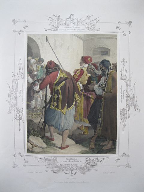 "The Taking of Monomvasia by Kantakuzenos." Munich H. Kohler c1835
Tinted lithograph, with modern colour, of the taking of Monomvasia from Peter von Hess's Album of Greek Heroism, or the Deliverance of Greece / Griechenlands Befreiung ... in XXXIX Bildern.[ First edition.] within decorative borders incorporating captions in Greek, German, French & English. The borders are decorated with guns, swords and helmets with the Greek flag to the left; on the right a crucifix and other emblems of the Christian church; at the top Turkish weapons, laid down, with a fez ,and below, sails and naval instruments.
in April 1821 prince Alexandros Ypsilantis sent Alexandros Kantakouzenos with prince Demetrios Ypsilantis to Peloponnesosto attack the Ottoman rule there. Alexandros Kantakouzenos participated actively in the revolution and was indeed a leader of Greek troops which made the Ottomans to surrender the fortress of Monemvasia in the summer of 1821. Image bright and clean.
Not in Blackmer ,Droulia or Contominas. 585 by 420mm (23 by 16½ inches) full page. €650
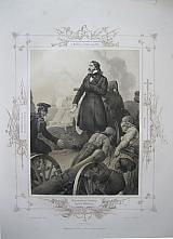
Iakovos "Yiakoumakis" Tombazis
 "I. Tombasis, burning a Turkish ship of the line" Munich H. Kohler c1835
Tinted lithograph, as issued, of Iakovos Tombaziz from Peter von Hess's Album of Greek Heroism, or the Deliverance of Greece / Griechenlands Befreiung ... in XXXIX Bildern.[ First edition.] within decorative borders incorporating captions in Greek, German, French & English. The borders are decorated with guns, swords and helmets with the Greek flag to the left; on the right a crucifix and other emblems of the Christian church; at the top Turkish weapons, laid down, with a fez ,and below, sails and naval instruments.
Iakovos "Yiakoumakis" Tombazis c. 1782-1829) was a merchant and ship-owner from the Greek island of Hydra who became the first Admiral of the Greek Navy, during the Greek War of Independence.
In 1818, he was initiated into the Filiki Eteria, which was preparing the ground for the revolt. When the war broke out, his fellow islanders made Tombazis admiral of the fleet of Hydra. He took part in several clashes against the Sultan's Navy in the eastern Aegean and soon realized that the Greek warships, being mostly converted and armed merchantmen, could not face the Ottoman ships of the line in conventional combat. He therefore proposed the use of fireships instead, and sent Dimitrios Papanikolis to burn the Turkish frigate Moving Mountain anchored at Eresos on Lesbos. Image bright and clean; light spotting to blank borders.
Not in Blackmer ,Droulia or Contominas. 540 by 410mm (21¼ by 16¼ inches) full page . €850
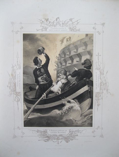
Mavrocordatos at Missolonghi.
 J.B. Kuhn after Peter von Hess.
Mavrocordatos defends Missolonghi. "Mavrocordtos defends Missolonghi victoriously". Munich H. Kohler c1835
J.B. Kuhn after Peter von Hess.
Mavrocordatos defends Missolonghi. "Mavrocordtos defends Missolonghi victoriously". Munich H. Kohler c1835Tinted lithograph, as issued, of Alexander Mavrocordatos on the walls of Missolonghi from Peter von Hess's Album of Greek Heroism, or the Deliverance of Greece / Griechenlands Befreiung ... in XXXIX Bildern.[ First edition.] within decorative borders incorporating captions in Greek, German, French & English. The borders are decorated with guns, swords and helmets with the Greek flag to the left; on the right a crucifix and other emblems of the Christian church; at the top Turkish weapons, laid down, with a fez and below, sails and naval instruments.
The image shows Mavrocordatos on the walls of Missolonghi, looking out to sea as a canon is pulled into position.
The first siege of Missolonghi ,October 25 – December 31, 1822 was laid after the Battle of Peta ,Omer Vryonis initially tried to take the town by negotiations, against the opinion of Reşid Mehmed and Yussuf Pasha of Patras. The besieged Greeks took advantage of this, dragging the negotiations out until November 8, when they were reinforced by sea with over 1,500 fighters. Then the Ottomans realized their mistake, and resumed the siege in earnest. After a month of bombardment and sorties, the main Ottoman assault was set for the night of December 24, before Christmas, calculating that the Greeks would be caught by surprise. The Greeks however were warned by Vryonis' Greek secretary, and the attack failed. The siege was subsequently lifted on December 31.
Missolonghi remained under Greek control, and resisted another Ottoman attempt at its capture a year later. Its resistance achieved wider fame when Lord Byron arrived there, dying in the town of fever in April 1824. The city was besieged for a third and final time, resisting both Ottoman and Egyptian armies for almost a year, until its final fall on April 10, 1826. Image bright and clean; spotting to blank borders; short tear (15mm) at upper edge.
Not in Blackmer ,Droulia or Contominas. 540 by 410mm (21¼ by 16¼ inches)full page. €750
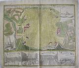
Topographical Plan of Paris
 "Carte Topographique des Environs & du Plan de Paris leveé par Msr l'Abbé Delagrive, & Copie selon l'original Parisien par les heritiers de feu Dr Homann." " Karte von der Gegend und GunDdrisder Stadt Paris..." Nuremberg Homœnisehen Erben. Homann Heirs. 1739
Copper engraved town plan of Paris and environs by Homann Heirs Original colour; title and text in French and German;verso blank.
The plan is based on Abbé Jean Delagrive's map of 1738 showing the greater environs of Paris at the time, many of today's districts appear as villages; with a key listing 63 landmarks. Extremely detailed, showing land use, buildings and roads. Coat of arms above key. Good impression; worm tracks ( approx 15 & 5mm) to key, 3 tiny worm holes to image and a couple more plus a short track to left margin.
435 by 613mm (17¼ by 24¼ inches). €800
The Americas.
 America "Totius Americae Septrionalis et Meridionalis Novissima Representatio quam ex singulis Geographorum Tabulis collecta luci publicae accommodavit .." Nuremberg Homann, Johann Baptist c1720
Copper engraved map of the continent of America by Johann Bapt. Homann from his "Grosser Atlas" . Original colour, verso blank.
Decorative title cartouche and vignette showing native Americans and the fauna and flora of the country,with another cartouche surrounding description of discoveries, black and white as issued. The title cartouche is based upon De Fer's landmark map of 1699. The top cartouche is based upon De L'Isle's 1703 map of Canada. The map is a revision of the elder Homann's 1710 map of the Americas. After his death in 1724, his son (Johann Christoph Homann) re-engraved the plate to correct the western coastline of North America, shown here extending very far west and north, with very little detail. California is no longer shown as an island, although the remnants of the interior sea can be seen near the Pais de Moozemleck, and a hint of a hoped for Northwest Passage is beginning to take shape. The Great Lakes are taking shape, being actively explored by the French fur traders and Hudson Bay Company. Good impression; old rust marks to upper margin (from a paperclip) just entering scale; small hole to left of these in blank margin; small rust spot east of the Solomon islands.
490 by 583mm (19¼ by 23 inches). €1300
The Americas.
 America North and South Newly represented... "Totius Americae Septrionalis et Meridionalis Novissima Representatio quam ex singulis Geographorum Tabulis collecta luci publicae accommodavit .." Nuremberg Homann, Johann Baptist c1720
Copper engraved map of the continent of America by Johann Bapt. Homann from his "Grosser Atlas". Original colour, verso blank.
Decorative title cartouche and vignette showing native Americans and the fauna and flora of the country, with another cartouche surrounding a description of discoveries, black and white as issued. The title cartouche is based upon De Fer's landmark map of 1699. The top cartouche is based upon De L'Isle's 1703 map of Canada. The map is a revision of the elder Homann's 1710 map of the Americas. After his death in 1724, his son (Johann Christoph Homann) re-engraved the plate to correct the western coastline of North America, shown here extending very far west and north, with very little detail. California is no longer shown as an island, although the remnants of the interior sea can be seen near the Pais de Moozemleck, and a hint of a hoped for Northwest Passage is beginning to take shape. The Great Lakes are taking shape, being actively explored by the French fur traders and Hudson Bay Company. Good dark impression, generally bright and clean; slight soiling to lower corners; short centrefold split at lower margin [40m just entering scale lines with old tape repair to verso]; slight unobtrusive vertical crease to right of centrefold.
490 by 583mm (19¼ by 23 inches). €1600
The Continent of Europe.
 Europe. "Europa Christiani Orbis Domina, in sua Imperia Regna et Status...." Nuremberg Homann, Johann Baptist c1720
Copper engraved map of the continent of Europe by Johann Bapt. Homann from his "Grosser Atlas" Original colour, verso blank.
Decorative title cartouche black and white as issued. Fair impression; title cartouche some what weak impression by Iceland; lower centrefold tear, repaired, by use of guard at verso.
490 by 583mm (19¼ by 23 inches). €650
Plan of Madrid
 Madrid "Accurater grundriß der Konigl.spanischen Haupt und Residentz Stadt Madrit mit denen Prospecten des Konige Schlosses und andern Lust Gubænen.." Nuremberg Homann, Johann Baptist. 1730
Copper engraved town plan of Madrid from Johann Bapt. Homann's "Grosser Atlas.". Original full colour, verso blank.
The town plan shows the city with the royal palaces and gardens; two black & white vignettes to corners; 4 views below of: the Royal palace; Place Mayor with bullfight; the Royal pleasure gardens, Buen Retiro and a view of Hermitage St. Antonio de la Florida, [black & white as issued]. Slightly weak impression, but generally clean except for some soiling to margins, heavier to lower corners; short tear, repaired, to upper margin; "MADRID'" in biro to verso.
Fauser, 8265. 490 by 594mm (19¼ by 23½ inches). €750
The Kingdoms of Morocco with prospects of the Imperial cities of Marrakesh & Meknes.
 Morocco. the kingdoms of Fes, Morocco, Tafilalet and Sijilmasa . "STATUUM MAROCCA NORUM. REGNORUM NEMPE FESSANI, MAROCCANI, TAFILETANI ET SEGELOMESSANI secundum suas provincias accurate divisorum..." Nuremberg Homann, Johann Baptist 1728
Copper engraved map of Moroccoc by Johann Bapt. Homann from his "Grosser Atlas" . Original colour, verso blank.
The map shows the ancient Kingdoms of Fes, Morocco, Tafilalet and Sijilmasa, with two views below of the imperial cities of Marrakesh and Meknes.
The Canary Islands are shown and also a small inset map of the Madeira Arhipelago
Decorative title cartouche with merchants and wild animals including a magnificent lion and strange serpent; with a vignette [somewhat faded ] of a sea battle off Tangier
the two views include keys to the important edifices of the cities
Meknes / Mequinetz was the capital of Morocco under the reign of Moulay Ismail (1672–1727), before it was relocated to Marrakech. Fair impression, some what light to cartouche & vignette, prospects could be darker ; light soiling to blank margins; old tape to lower centrefold in blank margin causing discolouration [not entering image].
492 by 574mm (19¼ by 22½ inches). €650
Scotland.
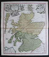 Scotland "Magnæ Brittaniæ pars Septrionalis qua REGNUM SCOTIÆ..." Nuremberg Homann, Johann Baptist c1720
Copper engraved map of the continent of Scotland by Johann Bapt. Homann from his "Grosser Atlas" Original colour, verso blank.
Decorative title cartouche black and white as issued. Dark impression; bright full wash colour.
590 by 496mm (23¼ by 19½ inches). €500
Plan of Stockholm.
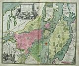 Stockholm. "Accurater grundriß ubd Prospect Der Kön Schwed. Reichs. u .Hauptstadt Stockholm..." Nuremberg Homann, Johann Baptist 1730
Copper engraved town plan of Stockholm from Johann Bapt. Homann's "Grosser Atlas.". Original full colour, verso blank.
Decorative title cartouche and scale, black and white as issued Dark impression; bright colours; light spotting to blank margins; darker spots to lower blank margin, one within the plate.
490 by 594mm (19¼ by 23½ inches). €1300
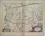
St Petrsburg, Ingria, Russia.
 The Most Up-to-date Record of Ingermanland or Ingria. " Ingermanlandiae seu Ingriae Novissima Tabula .." Nuremberg Homannianos Heredes 1734
Copper engraved map of Ingria from Johann Bapt. Homann's "Grosser Atlas.". Original full colour, verso blank.
The map shows Ingria the area around St Petersburg. Ingria on the Gulf of Finland was a disputed territory for centuries, annexed to Russia by Peter the Great in 1721 at the conclusion of the Great Northern War with Sweden.
The region formed a protective land barrier around his new city of St. Petersburg, depicted at upper left, in black & white vignette with war ships [Peter's newly organised navy?] to the foreground; the whole held aloft as if on a tapestry by three putti. Decorative title cartouche at the lower right, surrounded by various sea nymphs paying homage to Posidon, God of the Sea with Aphrodite on her sea shell. Good dark impression; bright and clean ; old ink number to upper right coner; minor soiling to blank margins with light dampstain to upper and lower edges; blue crayon? line to upper left corner just entering plate; minor chips to lower edge.
493 by 580mm (19½ by 22¾ inches). €800
Sund Sound with a Prospect of the City of Copenhagen.
 Accurate presentation of the famous sea-strait between the North and East of the lake called Sund; with surrounding area of Zealand and Scania, along with the Royal palace and city of COPENHAGEN.. " Accurate Vorstellung der Beruhmten Meer-Enge Zwischen der Nord und Ost See der Sund Genant, mit der herumligenden Gegend von Seeland und Schonen nebst der Koniglich-Danischen Haupt und Residentz Stadt Copenhagen.." Nuremberg Homann, Johann Baptist. 1720
Copper engraved map of Copenhagen and the sound of Sund from Johann Bapt. Homann's "Grosser Atlas.". Original colour to map; vignettes black & white as issued; verso blank.
The map in the upper two thirds of the plate shows the position of Copenhagen on the Sund sound with the coast of Sweden opposite. Inset vignette to upper left with views of Malmo, Landschorn and Helsingburg; to the right vignette of the castle of Cronenburg, within decorative scrollwork frame; below the map a full prospect of the city of Copenhagen. Fair impression; bright colours; trimmed to plate mark at sides, at some time remargined with old laid paper which is slightly toned; short tear (approx 20mm). close to lower centrefold [repaired with archival tape to verso],and slight centrefold split.
495 by 577mm (19½ by 22¾ inches). €800
Plan of the Immortal victory of Corfu/ Kerkyra Beseiged by the Ottomans.
 Plan of the place of Corfu seiged by the infidels between the 25th July and the 22nd August ...1716. "Plan de la place de Corfu avec ses environs, assiegee par les infidels, tranchee ouvert le25em Juillet jusqu'au 22eme d Aout jour de la fuite des ottomans defendue par s.e.le Feldt Marechal comte de Schulembeourg General en chef des armées de la Serme Repque.. de Venise en l'an MDCCXV.." " Nomini Immortali Invict Corcyrae Defensoris." Nuremberg. Homann, Johann Baptist. c1716
Copper engraved plan of Corfu city/ Kerkyra by Johann Bapt. Homann. Original colour, verso blank.
The map shows the siege of the citadel of Corfu by the Ottomans between July 25 and August 22nd 1716, with the island of Vido. The image shows the fortifications and lines of attack. Set within a decorative frame with profiles of the castles in each corner; detailled key to 3 sides the plan set within a second frame. Large decorative vignette of Victory amid cannons with a portrait of Field Marshall Schulemberg, held aloft by angels.
In 1716, Corfu was the scene of one of the fiercest attacks by the Turks. Their forces were said to number 35,000 men and they besieged the citadel by land and sea. The defending forces were commanded by a distinguished German mercenary, Count Schulemberg, who was appointed by Prince Eugene of Austria. After six bloody weeks in July and August 1716 the Turks withdrew from Corfu. The cartouche on a manuscript drawing now in the British Library and probably prepared on the spot, reads:
"The Turks abandoned the Isle of Corfu with the loss of 70 pieces of cannon, 30 mortars, 2000 horses, 1500 buffalos, 1000 oxen, 3000 tents and out of 35000 men there were slain 15000 and prisoners of war 2000."
Corfu tradition has it that their patron saint, St Spiridon, appeared on his donkey accompanied by acolytes, candles in hand, and bringing a great thunderstorm. His appearance so terrified the Turks that they abandoned their encampments forthwith. It is the German cartographer Johann Baptist Homann who best captures the great battle in contemporary maps. The siege of Corfu has been called 'the last glorious military exploit in the annals of the Venetian Republic. Dark impression; bright and clean; cartouche black & white as issued; old ink number to verso
Zacharakis: 1646. 495 by 565mm (19½ by 22¼ inches). €850
Greek Monuments and Antiquities.
 Gallery of Greek Antiquities "Bilder des Griechischen Alterhums" Zürich Orell, Füssli und Comp 1823
4to.[πii] 1-124, 131, 14-234, lithographed additional title and 71 plates and maps numbered 1-72 (nos 14 &15 used for the folding plate of Athens) Black & white lithographs. Some spotting throughout effecting some text and plates Plate XiX heavily spotted. Quarter calf gilt over marbled boards. Head of spine repaired, joints rubbed.
Blackmer/ Navari: 830 (this copy); Blackmer/Sotheby's 694. 300 by 235mm (11¾ by 9¼ inches). €3000
Macedonia, Homeland of Alexander the Great.
 "N. Visscher excudit."
Macedonia. "Macedonia Alexandri M. Patria Illustris. Auctore J Laurenbergio." Amsterdam J. Janssonius 1650
"N. Visscher excudit."
Macedonia. "Macedonia Alexandri M. Patria Illustris. Auctore J Laurenbergio." Amsterdam J. Janssonius 1650Copper engraved map of the ancient country of Macedonia after Laurenberg by Janssonius. Original colour; verso blank.
The map shows the whole of Macedonia at the time of Alexander the Great, with Thessaly and Epirus to the South
Large decorative title cartouche [original colour] to lower right corner and scale to lower left with a strangely top hatted figure surrounded by putti. Sailing ships to sea.
The map first appeared in Janssonius' "Atlantis Majoris Quinta Pars, Orbem Maritimum" and later in 1552 in the 6th Volume entitled "Accuratissma Orbis Antiqui Delineatio Sive Geographia vetus, sacra,& profana." Good dark impression, bright colour; slight discoloration down centre fold due to guard on verso; slight creasing to right of centre fold; short tear [8mm] to lower edge; old ink number to upper right corner.
Zacharakis 1905/1276 .Koeman II; Me.164 [614] 412 by 573mm (16¼ by 22½ inches). €650
The Northern Aegean in Ancient times.
 "N. Visscher excudit."
Northern Aegean Archipelago. "Insularum Archipelagi Septrionalis seu Maris Ægæ, Accurata Delinatio Auctore J Laurenbergio." Amsterdam J. Janssonius 1650
"N. Visscher excudit."
Northern Aegean Archipelago. "Insularum Archipelagi Septrionalis seu Maris Ægæ, Accurata Delinatio Auctore J Laurenbergio." Amsterdam J. Janssonius 1650Copper engraved map of the Northern Archipelago after Laurenberg by Janssonius. Original colour; verso blank.
The map shows the Northern Aegean with the islands of the Northern Archipelago: Limnos, Mytelline, Chios Samos, Imbro etc; Mount Athos and Skyros with the Sporades to the left and the coast of Asia Minor to the right.
Decorative title cartouche [ original colour]. Sailing ships to sea. Laurenberg's map is of the area in ancient times, giving the ancient names.
The map first appeared in Janssonius' "Atlantis Majoris Quinta Pars, Orbem Maritimum" and later in 1552 in the 6th Volume entitled "Accuratissma Orbis Antiqui Delineatio Sive Geographia vetus, sacra,& profana." Good dark impression, generally bright; light offsetting and ocassional spots; short split at lower centre fold and two minor tears[ backed with archival tape].
Zacharakis 1905/1276 .Koeman II; Me.164 map 676. 485 by 582mm (19 by 23 inches). €800
Persephone 's Offerings to Demeter.
 Offerings to Ceres. "Offrande a Cerès" Paris. Jacques Firmin Beauvarlet. c1763.
Copper engraving by Beauvarlet of Persephone decorating a statue of her mother Demeter [ Ceres] after the painting by Joseph-Marie Vien exhibited at the Paris salon in 1763 entitled Proserpine orne de Fleurs le buste de Cérès sa mere. On a pris le moment qui précede celui où elle fut enlevée par Pluton
Later hand colour. [The engraving is a reversed image of the painting]. Generally bright and clean; minor dampstain to upper left corner, far from image; laid to card.
Thomas Gaehtgens, Jacques Lugand, Joseph-Marie Vien, Arthéna, 1988, p. XIII, notice w7050 452 by 310mm (17¾ by 12¼ inches). €750
The Acropolis, Athens.
 James Stuart. Lerpiniere Sculpt.
"A view of the Acropolis, taken from the situation of the ancient Piraïc Gate. " London John Nichols. 1787
James Stuart. Lerpiniere Sculpt.
"A view of the Acropolis, taken from the situation of the ancient Piraïc Gate. " London John Nichols. 1787Large copper engraved panoramic view of the Acropolis. from the second volume of Stuart & Revett's "Antiquities of Athens". This magnificent view engraved from sketches made by James Stuart during his and Nicholas Revett's surjourn in Athens 1751-55, shows the position of the Acropolis and the various attendant temples. and buildings.
In the foreground he depicts a group of eminent Turks engaged in Jereet.The personages depicted include the Vaïvode of Athens, about to throw the jereet, the Disdár Agá, and the Mudereese Effendi " conversing with Achmét Agá, the richest and most respectable Turkish gentleman of Athens:".Stuart, whilst engaged in a project which was scientific in bases, i. e. to "Measure and Delineate" the antiquities in Athens, also shows a diplomatic touch by portraying such eminent Turks in this distinguished view. Stuart and Revett had not been permitted to survey the Acropolis until a few months before they left Greece, so perhaps it was a tribute to those who had finally given permission. Clean. dark impression; folded; left margin cut short by binder to edge of platemark; right margin outside platemark shows were the plate was bound into the volume.
Blackmer/Navari: 1618; BAL RIBA :3183. 410 by 737mm (16¼ by 29 inches). €2500
Large Panoramic View of Athens from Kolonaki.
 James Basire Sculpt.
"The General View of Athens" London John Haberkorn. 1762
James Basire Sculpt.
"The General View of Athens" London John Haberkorn. 1762Large copper engraved panoramic view of Athens from the first volume of Stuart & Revett's "Antiquities of Athens". engraved by James Basire.
This magnificent view engraved from sketches made by James Stuart during his and Nicholas Revett's surjourn in Athens 1751-55.
The large panoramic view shows the two columns forming a gateway, one stands today in Kolonaki Square whilst the pediment and the other column rest nearby in the Botanic Gardens. Around the gate are a group of Ottoman huntsmen with their hounds, horses and attendants; in the mid ground stands the Acropolis with the buildings of the Plaka on its slopes; the Thesion and the Temple of Zeus Olympus nearby.
In the text Stuart tells us that the view is taken from the foot of Mount Anchesmus." a general view of Athens and the adjacent Country with the Saronic Gulf, the islands of Salamis and Ægina and the shores of the Peloponnesus from Corinth to Cape Scylleum.... The two columns on the fore ground are the Remains of a Building, called by Wheler and Spon the Aquaduct of Hadrian , tho' it seems to be the Front of a Reservoir, that supplied apart of Athens with Water."
Dark impression; light toning mainly to blank margins; centrefold; side margins cut short to plate mark by the binder.
Blackmer/Navari: 1618; BAL RIBA :3183. 390 by 735mm (15¼ by 29 inches). €2850
Attica and Environs in Ancient times.
 "N. Visscher excudit."
Attica and Environs. "Attica Megarica,Corinthiaca Bœotia Phocis. Locri. Ex clariss D,T Velij M.D. Delineationes" Amsterdam Janssonium, Joannem. c1652
"N. Visscher excudit."
Attica and Environs. "Attica Megarica,Corinthiaca Bœotia Phocis. Locri. Ex clariss D,T Velij M.D. Delineationes" Amsterdam Janssonium, Joannem. c1652Copper engraved map of Attica and environs by Janssonius from his "Accuratissma Orbis Antiqui Delineatio Sive Geographia vetus, sacra,& profana." the 6th volume of the "Atlas Novus." Original colour; verso blank.
The map shows Attica and surrounding areas with the isthmus of Corinth and the island of Euboa; it is the cartography of Henricus Hondius [Zacharakis 1709/1121] with Hondius name removed and the cartouche changed to lower left corner, with Janssonius' imprint to upper right.
Decorative title cartouche; sailing ships to sea. Good impression, generally bright; occasional spotting mainly to blank margins; light toning to edges and slight browning to centre fold due to guard on verso; old ink number to upper right corner.
Zacharakis 1706/1120; Koeman II; Ja 2 & Me.164 368 by 498mm (14½ by 19½ inches). €500
Company: Bryan, Mary Louise.
Address: Ag. Andrianoy 92 , 21 100 Nafplio, Greece.
Vat No: EL 119092581